 B-52 Crash Site memorial with Inver Grove Heights water tower in the background
 Plaque commemorating those who died in the B-52 crash
 Rock Island Swing Bridge in 2008
 Rock Island Swing Bridge Park
 Salem Evangelical Church
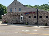 Former Duke's Restaurant location, now Jersey's Bar and Grill
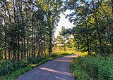 Bike Trail in Inver Grove Heights
 Inver Hills Fine Arts Building
world.wikisort.org - USA
Inver Grove Heights is a city in Dakota County, Minnesota, United States. The population was 35,801 at the 2020 census.[2] The city was formed on March 9, 1965, with the merger of the village of Inver Grove and Inver Grove Township.[5]
Inver Grove Heights, Minnesota | |
|---|---|
City | |
 | |
| Nickname: Inver Grove | |
 Interactive map outlining Inver Grove Heights | |
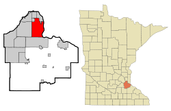 Location of Inver Grove Heights, Minnesota | |
| Coordinates: 44°50′15″N 93°3′6″W | |
| Country | United States |
| State | Minnesota |
| County | Dakota |
| Established | 1852 |
| Incorporated | March 9, 1965 |
| Government | |
| • Type | Weak Mayor–Council |
| • Mayor | Tom Bartholomew |
| Area | |
| • Total | 30.22 sq mi (78.27 km2) |
| • Land | 27.85 sq mi (72.14 km2) |
| • Water | 2.37 sq mi (6.13 km2) |
| Elevation | 879 ft (268 m) |
| Population (2020)[2] | |
| • Total | 35,801 |
| • Estimate (2021)[3] | 35,541 |
| • Density | 1,285.31/sq mi (496.25/km2) |
| Time zone | UTC-6 (CST) |
| • Summer (DST) | UTC-5 (CDT) |
| ZIP codes | 55076, 55077 |
| Area code | 651 |
| FIPS code | 27-31076 |
| GNIS feature ID | 0645437[4] |
| Website | ighmn.gov |
It is one of 186 cities and townships in the seven-county Minneapolis-Saint Paul metropolitan area.[6] Inver Grove Heights is 9 miles (14 km) southeast of Saint Paul; nearby communities are South St. Paul, West St. Paul, Sunfish Lake, Eagan, Newport, and Saint Paul Park (the last two across the Mississippi River).
History

Map of Inver Grove in 1874
After the signing of the Treaty of Traverse des Sioux in 1851, settlers from Ireland and Germany quickly staked claims in the rolling countryside west of the Mississippi River. Those of Irish descent farmed the eastern part of the community, while Germans cleared the wooded land to the west for their farms. French and English settlers built their homes along the river. The township of Inver Grove Heights was named after the Irish fishing village of Inver and the German town of Grove.[5] Records show that 240 farms, four churches, and four school districts were founded by 1880.[7] On March 9, 1965, the village of Inver Grove and Inver Grove Township merged to form Inver Grove Heights.[8]
Historic sites in Inver Grove Heights include:
- Chief Medicine Bottle's Village: formed in 1836, became Pine Bend village and post office[8]
- Mendota-Wabasha Road: a military road laid out by John S. Potter in 1853. Rich Valley Road now follows the old military road.[8]
- District 7 School: Dakota County's first public school, established in 1854[8]
- Salem United Methodist Church, organized in 1854[8]
- Old Emanuel Lutheran Church, site of first log church in 1854; services and church school were in German[8]
- Church of St. Patrick: Catholic church parish established on January 9, 1856[9]
- Salem Evangelical Church: First congregation in Minnesota of the Evangelical Association of North America was organized here on March 2, 1857[10]
- Josiah Burwell's House: where Inver Grove Township was first organized in 1858, at Rich Valley Road and 102nd Street[8]
- Reuben Freeman House of eight gables: built in 1876 to one-up the House of Seven Gables[8]
- Inver Grove Town Hall: first town hall building, built in 1878[8]
- Inver Grove Village railway depot: built in 1886[8]
- Rock Island Swing Bridge: Built in 1894, the double-decker swing bridge spanned the Mississippi River between Inver Grove Heights and St. Paul Park. Closed to rail traffic in 1980 and to road traffic in 1999, it opened as Swing Bridge park in 2011.[11][12]
- Duke's Restaurant: built in 1906 as Pierkarski's butcher shop; restaurant offered food to railway workers; later became Jersey's Bar[8]
- B-52 Crash Site: on September 16, 1958, a U.S. Air force B-52D bomber crashed while on a Cold War training mission originating from Loring Air Force Base, Limestone, Maine. Seven crewmen gave their lives for their country; marker on Broderick near West Loop Court[13]
Geography
According to the United States Census Bureau, the city has an area of 30.12 square miles (78.01 km2), of which 27.76 square miles (71.90 km2) is land and 2.36 square miles (6.11 km2) is water.[14]
Interstate Highway 494 (a beltway bypass of Minneapolis–Saint Paul), U.S. Highway 52, Minnesota Highway 55, and Minnesota Highway 3 are four of Inver Grove Heights's main routes. 80th Street East (numbered from downtown Saint Paul) crosses the city in an east–west direction.
In 2022, a meteoric impact crater was identified in the Pine Bend Bluffs Scientific and Natural Area in southern Inver Grove Heights. It has been informally named the "Pine Bend impact" and has been dated to 500 million years ago. It has a diameter of about four kilometers.[15]
Demographics
| Historical population | |||
|---|---|---|---|
| Census | Pop. | %± | |
| 1860 | 646 | — | |
| 1870 | 971 | 50.3% | |
| 1880 | 791 | −18.5% | |
| 1890 | 1,211 | 53.1% | |
| 1900 | 1,402 | 15.8% | |
| 1910 | 1,384 | −1.3% | |
| 1920 | 1,573 | 13.7% | |
| 1930 | 1,617 | 2.8% | |
| 1940 | 1,887 | 16.7% | |
| 1950 | 2,419 | 28.2% | |
| 1960 | 6,266 | 159.0% | |
| 1970 | 12,148 | 93.9% | |
| 1980 | 17,171 | 41.3% | |
| 1990 | 22,477 | 30.9% | |
| 2000 | 29,751 | 32.4% | |
| 2010 | 33,880 | 13.9% | |
| 2020 | 35,801 | 5.7% | |
| 2021 (est.) | 35,541 | [3] | −0.7% |
| U.S. Decennial Census[16] 2020 Census[2] Note: Inver Grove and Inver Grove Township were merged in 1965 to form Inver Grove Heights. | |||
2010 census
As of the census of 2010, there were 33,880 people, 13,476 households, and 9,036 families living in the city. The population density was 1,220.5 inhabitants per square mile (471.2/km2). There were 14,062 housing units at an average density of 506.6 per square mile (195.6/km2). The racial makeup of the city was 85.7% White, 3.8% African American, 0.4% Native American, 3.4% Asian, 0.1% Pacific Islander, 3.5% from other races, and 3.1% from two or more races. Hispanic or Latino of any race were 8.9% of the population.
There were 13,476 households, of which 32.9% had children under the age of 18 living with them, 51.4% were married couples living together, 11.4% had a female householder with no husband present, 4.3% had a male householder with no wife present, and 32.9% were non-families. 26.2% of all households were made up of individuals, and 8.8% had someone living alone who was 65 years of age or older. The average household size was 2.50 and the average family size was 3.04.
The median age in the city was 38.4 years. 24.5% of residents were under the age of 18; 8.5% were between the ages of 18 and 24; 26.3% were from 25 to 44; 29.1% were from 45 to 64; and 11.8% were 65 years of age or older. The gender makeup of the city was 48.0% male and 52.0% female.
2000 census
As of the census of 2000, there were 29,751 people, 11,257 households, and 7,924 families living in the city. The population density was 1,038.8 people per square mile (401.1/km2). There were 11,457 housing units at an average density of 400.1 per square mile (154.5/km2). The racial makeup of the city was 91.80% White, 2.10% African American, 0.48% Native American, 2.01% Asian, 0.02% Pacific Islander, 1.73% from other races, and 1.86% from two or more races. Hispanic or Latino of any race were 4.22% of the population.
There were 11,257 households, out of which 37.3% had children under the age of 18 living with them, 56.4% were married couples living together, 10.3% had a female householder with no husband present, and 29.6% were non-families. 21.5% of all households were made up of individuals, and 4.7% had someone living alone who was 65 years of age or older. The average household size was 2.62 and the average family size was 3.09.
In the city, the population was spread out, with 27.3% under the age of 18, 9.2% from 18 to 24, 33.9% from 25 to 44, 21.7% from 45 to 64, and 7.8% who were 65 years of age or older. The median age was 34 years. For every 100 females, there were 98.2 males. For every 100 females age 18 and over, there were 94.5 males.
The median income for a household in the city was $59,090, and the median income for a family was $68,629. Males had a median income of $45,369 versus $32,080 for females. The per capita income for the city was $25,493. About 3.0% of families and 4.2% of the population were below the poverty line, including 5.2% of those under age 18 and 4.9% of those age 65 or over.
Economy
In 2007, the Metropolitan Council estimated the employment in Inver Grove Heights to be 11,158.[17] The city hosts the headquarters of CHS, Inc., an agricultural cooperative ranked 12th in the 2007 ICA Global 300 list of mutuals and cooperatives, and 145th on the Fortune 500 list of U.S. corporations.[18][19] Pine Bend Refinery, the largest oil refinery in Minnesota and fourteenth largest in the U.S., straddles the border with Rosemount. It is operated by Flint Hills Resources.
Inver Grove Heights is also the home of Gertens Greenhouses, one of the largest garden centers in the Midwest.[20]
Top employers
According to Inver Grove Heights's 2021 Comprehensive Annual Financial Report,[21] the largest employers in the city are:
| # | Employer | # of Employees |
|---|---|---|
| 1 | Cenex / CHS Cooperatives | 1,600 |
| 2 | ISD 199 (Inver Grove Heights Community Schools) | 668 |
| 3 | Gertens | 435 |
| 4 | City of Inver Grove Heights | 421 |
| 5 | Travel Tags | 350 |
| 6 | Inver Hills Community College | 337 |
| 7 | Total Construction and Equipment | 250 |
| 8 | Walmart | 210 |
| 9 | Woodlyn Heights Senior Living | 200 |
| 10 | Cub Foods | 160 |
Education
The Inver Grove Heights Community Schools district or Independent School District 199 operates five schools in the city:
- Simley High School
- Inver Grove Heights Middle School[22]
- Hilltop Elementary School[23]
- Pine Bend Elementary School[24]
- Salem Hills Elementary School[25]
There is one private school for preschool through eighth grade in Inver Grove Heights: Berea Lutheran Church.[26]
The western part of the city is served by Independent School District 196, with students attending Dakota Hills Middle School, Rosemount Middle School, Eagan High School, and Rosemount High School.[27]
Inver Grove Heights is also home to Inver Hills Community College.
Government and politics
Inver Grove Heights's municipal government provides for a council of five members, one of whom is the mayor. The mayor is Tom Bartholomew, who is in his first term, elected in 2020 after spending the better part of three decades in local government.[28]
The other council members are:[29]
- Brenda Dietrich
- Sue Gliva
- John Murphy
- Rosemary Piekarski-Krech
In general, city government is nonpartisan. Candidates need not be selected or endorsed by political parties, and by state law no such endorsement appears on the ballot. The mayor is elected every two years while council members are elected every four. Terms are staggered with two council members elected one election cycle and the two others two years later. The non-mayoral seats are elected in pairs, giving voters the chance to vote for up to two candidates. If necessary, races are narrowed down during a primary election.[30]
As a part of Dakota County, Inver Grove Heights's northern and central precincts (1, 8-10) join with regions northward to form the Second District on the County Commission. It has been represented by former South St. Paul Mayor Kathleen A. Gaylord since 2003. The southern, eastern, and far western portions of the city (precincts 2-7) are joined by regions south and west to form the Fourth District of the County Commission, which has been represented by former State Representative and former Inver Grove Heights Mayor Joe Atkins since 2017. County commissioners serve four-year terms.[31]
Inver Grove Heights is in Minnesota's 2nd congressional district, represented by Angie Craig (DFL) since 2019.
The city is in the state's 52nd legislative district, represented in the Minnesota Senate by Matt Klein (DFL), and is entirely encompassed by House District 52B, represented by Ruth Richardson (DFL).
Election results
Presidential election results
| Year | Republican | Democratic | Third parties |
|---|---|---|---|
| 2020 | 41.3% 8,851 | 56.2% 12,034 | 2.5% 526 |
| 2016 | 42.4% 8,155 | 48.6% 9,354 | 9.0% 1,727 |
| 2012 | 45.0% 8,573 | 52.8% 10,042 | 2.2% 418 |
| 2008 | 43.4% 8,356 | 54.3% 10,468 | 2.3% 446 |
| 2004 | 46.7% 8,515 | 52.3% 9,531 | 1.0% 194 |
| 2000 | 42.0% 6,442 | 50.7% 7,763 | 7.3% 1,120 |
| 1996 | 30.9% 3,647 | 56.6% 6,691 | 12.6% 1,483 |
| 1992 | 27.0% 3,361 | 46.3% 5,754 | 26.7% 3,325 |
| 1988 | 40.8% 4,031 | 59.2% 5,845 | 0.0% 0 |
| 1984 | 44.2% 3,692 | 55.8% 4,654 | 0.0% 0 |
| 1980 | 36.3% 2,747 | 53.7% 4,069 | 10.0% 759 |
| 1976 | 36.9% 2,370 | 60.6% 3,892 | 2.5% 161 |
| 1968 | 31.6% 1,210 | 63.1% 2,414 | 5.3% 204 |
| 1964 | 10.7% 35 | 89.3% 291 | 0.0% 0 |
| 1960 | 25.6% 75 | 74.1% 217 | 0.3% 1 |
Sports and recreation
Facilities include Inver Wood Golf Course and Arbor Pointe Golf Club. There is also an 18-hole disc golf course called North Valley. The city also has a public community center with a waterpark, two sheets of ice and a full gym shared with the National Guard.
Gallery of images


External links
References
- "2020 U.S. Gazetteer Files". United States Census Bureau. Retrieved July 24, 2022.
- "Explorer Census Data". United States Census Bureau. Retrieved August 10, 2022.
- "City and Town Population Totals: 2020-2021". United States Census Bureau. August 10, 2022. Retrieved August 10, 2022.
- "US Board on Geographic Names". United States Geological Survey. October 25, 2007. Retrieved January 31, 2008.
- "About us". City of Inver Grove Heights, Minnesota. Retrieved September 15, 2008.
From 1858 until 1880, hundreds of settlers were attracted to the township that was named after an Irish fishing village, "Inver" and commemorating the homeland of the German settlers, "Grove."
- Metropolitan Council (May 1, 2008). "Snapshot of the Region". Archived from the original on February 9, 2002. Retrieved September 15, 2008.
- "About Inver Grove Heights". Inver grove Heights. Retrieved March 13, 2008.
- "A brief history of Inver Grove Heights from Township and Village to City with a map of historic sites" (PDF). Dakota History.org. Retrieved July 14, 2019.
- "Church of St. Patrick, Parish History". Retrieved July 14, 2019.
- "Salem Evangelical Church". Retrieved July 14, 2019.
- "Swing Bridge Park". Retrieved July 14, 2019.
- "Rock Island Swing Bridge". Retrieved July 14, 2019.
- "B-52 Crash Site Cold War Veterans Memorial". Retrieved July 14, 2015.
- "US Gazetteer files 2010". United States Census Bureau. Archived from the original on July 2, 2012. Retrieved November 13, 2012.
- "U of M scientists unearth massive meteoroid crash site under Inver Grove Heights". Retrieved September 30, 2022.
- United States Census Bureau. "Census of Population and Housing". Retrieved August 14, 2013.
- "Inver Grove Heights Profile". Metropolitan Council. Retrieved September 15, 2008.[permanent dead link]
- "Fortune 500: 145 CHS". Fortune. CNN. May 5, 2008. Retrieved September 15, 2008.
- "The 2007 Global 300 Listing" (PDF). International Co-operative Alliance.[permanent dead link]
- "History of Gertens Greenhouses". Retrieved July 14, 2019.
- "City of Inver Grove Heights 2021 Comprehensive Annual Financial Report" (PDF). August 10, 2022. p. 177.
- "Inver Grove Heights Middle School". Archived from the original on May 20, 2011. Retrieved July 14, 2019.
- "Hilltop Elementary". Archived from the original on July 11, 2011. Retrieved July 14, 2019.
- "Pine Bend Elementary". Archived from the original on April 25, 2011. Retrieved July 14, 2019.
- "Salem Hills Elementary". Archived from the original on August 20, 2010.
- "Berea Lutheran School". Retrieved July 14, 2019.
- "District 196". Retrieved July 14, 2019.
- "Tom Bartholomew: East Metro Voter Guide". East Metro Voter Guide. Retrieved 6 January 2021.
- "Mayor & Council". Retrieved 6 January 2021.
- "IGH Election Code". Retrieved 26 June 2020.
- "Board of Commissioners". Retrieved 26 June 2020.
- "Minnesota Secretary of State - 2020 Precinct Results Spreadsheet".
- "Minnesota Secretary of State - 2016 Precinct Results Spreadsheet".
- "Minnesota Secretary of State - 2012 Precinct Results Spreadsheet".
- "Minnesota Secretary of State - 2008 Precinct Results Spreadsheet".
- "Minnesota Secretary of State - 2004 Precinct Results Spreadsheet".
- "Minnesota Secretary of State - 2000 Precinct Results Spreadsheet".
- (PDF) https://www.lrl.mn.gov/archive/sessions/electionresults/1996-11-05-g-sec.pdf.
{{cite web}}: Missing or empty|title=(help) - (PDF) https://www.lrl.mn.gov/archive/sessions/electionresults/1992-11-03-g-sec.pdf.
{{cite web}}: Missing or empty|title=(help) - (PDF) https://www.lrl.mn.gov/archive/sessions/electionresults/1988-11-08-g-sec.pdf.
{{cite web}}: Missing or empty|title=(help) - (PDF) https://www.lrl.mn.gov/archive/sessions/electionresults/1984-11-06-g-sec.pdf.
{{cite web}}: Missing or empty|title=(help) - (PDF) https://www.lrl.mn.gov/archive/sessions/electionresults/1980-11-04-g-sec.pdf.
{{cite web}}: Missing or empty|title=(help) - (PDF) https://www.lrl.mn.gov/archive/sessions/electionresults/1976-11-02-g-sec.pdf.
{{cite web}}: Missing or empty|title=(help) - (PDF) https://www.lrl.mn.gov/archive/sessions/electionresults/1968-11-05-g-man.pdf.
{{cite web}}: Missing or empty|title=(help) - (PDF) https://www.lrl.mn.gov/archive/sessions/electionresults/1964-11-03-g-man.pdf.
{{cite web}}: Missing or empty|title=(help) - (PDF) https://www.lrl.mn.gov/archive/sessions/electionresults/1960-11-08-g-man.pdf.
{{cite web}}: Missing or empty|title=(help)
Municipalities and communities of Dakota County, Minnesota, United States | ||
|---|---|---|
County seat: Hastings | ||
| Cities |  | |
| Townships | ||
| Unincorporated communities | ||
| Ghost towns |
| |
| Indian reservation |
| |
| Footnotes | ‡This populated place also has portions in an adjacent county or counties | |
| ||
State of Minnesota | |||||
|---|---|---|---|---|---|
Saint Paul (capital) | |||||
| Topics |
| ||||
| Society |
| ||||
| Regions |
| ||||
| Largest cities pop. over 25,000 |
| ||||
| Counties |
| ||||
| Attractions |
| ||||
Authority control | |
|---|---|
| General | |
| National libraries | |
| Other |
|
На других языках
[de] Inver Grove Heights
Inver Grove Heights ist eine Stadt im US-Bundesstaat Minnesota. Sie ist im Dakota County gelegen und hat rund 29.800 Einwohner.- [en] Inver Grove Heights, Minnesota
[ru] Инвер-Гров-Хайтс
И́нвер-Гро́в-Ха́йтс (англ. Inver Grove Heights) — город в округе Дакота, штат Миннесота, США. На площади 78 км² (74,2 км² — суша, 3,8 км² — вода), согласно переписи 2002 года, проживают 29 751 человек. Плотность населения составляет 401,1 чел./км².Текст в блоке "Читать" взят с сайта "Википедия" и доступен по лицензии Creative Commons Attribution-ShareAlike; в отдельных случаях могут действовать дополнительные условия.
Другой контент может иметь иную лицензию. Перед использованием материалов сайта WikiSort.org внимательно изучите правила лицензирования конкретных элементов наполнения сайта.
Другой контент может иметь иную лицензию. Перед использованием материалов сайта WikiSort.org внимательно изучите правила лицензирования конкретных элементов наполнения сайта.
2019-2026
WikiSort.org - проект по пересортировке и дополнению контента Википедии
WikiSort.org - проект по пересортировке и дополнению контента Википедии