world.wikisort.org - USA
Cass County is a county in the central part of the U.S. state of Minnesota. As of the 2020 census, the population was 30,066.[2] Its county seat is Walker.[3] The county was formed in 1851, and was organized in 1897.
Cass County | |
|---|---|
U.S. county | |
 The Cass County Courthouse | |
 Location within the U.S. state of Minnesota | |
 Minnesota's location within the U.S. | |
| Coordinates: 46°57′N 94°19′W | |
| Country | |
| State | |
| Founded | September 1, 1851 (created) 1897 (organized)[1] |
| Named for | Lewis Cass |
| Seat | Walker |
| Largest city | Lake Shore |
| Area | |
| • Total | 2,414 sq mi (6,250 km2) |
| • Land | 2,022 sq mi (5,240 km2) |
| • Water | 393 sq mi (1,020 km2) 16%% |
| Population (2020) | |
| • Total | 30,066 |
| • Estimate (2021) | 30,639 |
| • Density | 14.9/sq mi (5.8/km2) |
| Time zone | UTC−6 (Central) |
| • Summer (DST) | UTC−5 (CDT) |
| Congressional district | 8th |
| Website | www |
Cass County is included in the Brainerd, MN Micropolitan Statistical Area.
A substantial part of the Leech Lake Indian Reservation is in the county.
History

Cass County was created on September 1, 1851, by the Minnesota Territory legislature, although its government was not organized until 1897. The county was formed of areas partitioned from Dakota, Mahkatah, Pembina and Wahnata Counties. It was named for Lewis Cass, a Michigan political figure of the 19th century.[4] Before it was organized several parcels of county land were partitioned off to augment or form adjacent counties.
![Soils of Cass County[5]](http://upload.wikimedia.org/wikipedia/commons/thumb/b/be/Cass_Co_Newest_No_Text_Version.pdf/page1-220px-Cass_Co_Newest_No_Text_Version.pdf.jpg)
Geography
The Crow Wing River flows east-southeast along Cass County's southern border, and the Gull River flows southwest through the lower part, to discharge into the Crow Wing on the southern border. The terrain consists of wooded rolling hills, heavily dotted with lakes and ponds,[6] and slopes to the south and east; its highest point is on the upper western border, at 1,614' (492m) ASL.[7] The county has an area of 2,414 square miles (6,250 km2), of which 2,022 square miles (5,240 km2) is land and 393 square miles (1,020 km2) (16%) is water.[8]
Major highways
 US Highway 2
 Minnesota State Highway 6
 Minnesota State Highway 34
 Minnesota State Highway 64
 Minnesota State Highway 84
 Minnesota State Highway 87
 Minnesota State Highway 200
 Minnesota State Highway 210
 Minnesota State Highway 371
- List of county roads
Adjacent counties
- Itasca County - northeast
- Aitkin County - east
- Crow Wing County - southeast
- Morrison County - south
- Todd County - southwest
- Wadena County - west
- Hubbard County - northwest
- Beltrami County - north
Protected areas
- Buena Vista State Forest (part)
- Chippewa National Forest (part)
- Crow Wing State Park (part)
- Foot Hills State Forest (part)
Climate and weather
| Walker, Minnesota | ||||||||||||||||||||||||||||||||||||||||||||||||||||||||||||
|---|---|---|---|---|---|---|---|---|---|---|---|---|---|---|---|---|---|---|---|---|---|---|---|---|---|---|---|---|---|---|---|---|---|---|---|---|---|---|---|---|---|---|---|---|---|---|---|---|---|---|---|---|---|---|---|---|---|---|---|---|
| Climate chart (explanation) | ||||||||||||||||||||||||||||||||||||||||||||||||||||||||||||
| ||||||||||||||||||||||||||||||||||||||||||||||||||||||||||||
| ||||||||||||||||||||||||||||||||||||||||||||||||||||||||||||
In recent years, average temperatures in the county seat of Walker have ranged from a low of 0 °F (−18 °C) in January to a high of 79 °F (26 °C) in July, although a record low of −44 °F (−42 °C) was recorded in February 1996 and a record high of 103 °F (39 °C) was recorded in August 1976. Average monthly precipitation ranged from 0.62 inches (16 mm) in February to 4.11 inches (104 mm) in July.[9]
Demographics
| Historical population | |||
|---|---|---|---|
| Census | Pop. | %± | |
| 1860 | 150 | — | |
| 1870 | 380 | 153.3% | |
| 1880 | 486 | 27.9% | |
| 1890 | 1,247 | 156.6% | |
| 1900 | 7,777 | 523.7% | |
| 1910 | 11,620 | 49.4% | |
| 1920 | 15,897 | 36.8% | |
| 1930 | 15,591 | −1.9% | |
| 1940 | 20,646 | 32.4% | |
| 1950 | 19,468 | −5.7% | |
| 1960 | 16,720 | −14.1% | |
| 1970 | 17,323 | 3.6% | |
| 1980 | 21,050 | 21.5% | |
| 1990 | 21,791 | 3.5% | |
| 2000 | 27,150 | 24.6% | |
| 2010 | 28,567 | 5.2% | |
| 2020 | 30,066 | 5.2% | |
| 2021 (est.) | 30,639 | [10] | 1.9% |
| U.S. Decennial Census[11] 1790-1960[12] 1900-1990[13] 1990-2000[14] 2010-2020[2] | |||
2000 census
As of the 2000 census,[15] there were 27,150 people, 10,893 households, and 7,734 families in the county. The population density was 13.4/sqmi (5.18/km2). There were 21,286 housing units at an average density of 10.5/sqmi (4.06/km2). The racial makeup of the county was 86.52% White, 0.11% Black or African American, 11.45% Native American, 0.28% Asian, 0.02% Pacific Islander, 0.14% from other races, and 1.47% from two or more races. 0.81% of the population were Hispanic or Latino of any race. 28.2% were of German, 15.0% Norwegian, 7.3% Swedish, 6.1% Irish and 6.1% American ancestry.
There were 10,893 households, out of which 27.70% had children under the age of 18 living with them, 58.40% were married couples living together, 8.00% had a female householder with no husband present, and 29.00% were non-families. 25.00% of all households were made up of individuals, and 11.90% had someone living alone who was 65 years of age or older. The average household size was 2.45 and the average family size was 2.90.
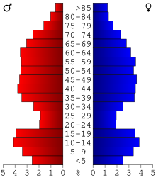
The county population contained 25.00% under the age of 18, 6.10% from 18 to 24, 23.00% from 25 to 44, 27.90% from 45 to 64, and 18.00% who were 65 years of age or older. The median age was 42 years. For every 100 females there were 101.90 males. For every 100 females age 18 and over, there were 100.60 males.
The median income for a household in the county was $34,332, and the median income for a family was $40,156. Males had a median income of $30,097 versus $21,232 for females. The per capita income for the county was $17,189. About 9.50% of families and 13.60% of the population were below the poverty line, including 18.20% of those under age 18 and 13.30% of those age 65 or over.
2020 Census
| Race | Num. | Perc. |
|---|---|---|
| White (NH) | 24,675 | 82.07% |
| Black or African American (NH) | 64 | 0.21% |
| Native American (NH) | 3,424 | 11.4% |
| Asian (NH) | 111 | 0.37% |
| Pacific Islander (NH) | 0 | 0% |
| Other/Mixed (NH) | 1,366 | 4.54% |
| Hispanic or Latino | 426 | 1.42% |
Communities
Cities
- Backus
- Bena
- Boy River
- Cass Lake
- Chickamaw Beach
- East Gull Lake
- Federal Dam
- Hackensack
- Lake Shore
- Longville
- Motley (partial)
- Pillager
- Pine River
- Remer
- Walker (county seat)
Census-designated place
Unincorporated communities
Townships
- Ansel Township
- Barclay Township
- Becker Township
- Beulah Township
- Birch Lake Township
- Blind Lake Township
- Boy Lake Township
- Boy River Township
- Bull Moose Township
- Bungo Township
- Byron Township
- Crooked Lake Township
- Deerfield Township
- Fairview Township
- Gould Township
- Hiram Township
- Home Brook Township
- Inguadona Township
- Kego Township
- Leech Lake Township
- Lima Township
- Loon Lake Township
- Maple Township
- May Township
- McKinley Township
- Meadow Brook Township
- Moose Lake Township
- Otter Tail Peninsula Township
- Pike Bay Township
- Pine Lake Township
- Pine River Township
- Ponto Lake Township
- Poplar Township
- Powers Township
- Remer Township
- Rogers Township
- Salem Township
- Shingobee Township
- Slater Township
- Smoky Hollow Township
- Sylvan Township
- Thunder Lake Township
- Torrey Township
- Trelipe Township
- Turtle Lake Township
- Wabedo Township
- Walden Township
- Wilkinson Township
- Wilson Township
- Woodrow Township
Unorganized territories
- Wahnena
- North Cass
- North Central Cass
- East Cass
Government and politics
Cass County tends to vote Republican. As of 2020 the county has selected the Republican nominee in 78% of presidential elections since 1980.
| Year | Republican | Democratic | Third party | |||
|---|---|---|---|---|---|---|
| No. | % | No. | % | No. | % | |
| 2020 | 11,620 | 63.54% | 6,342 | 34.68% | 327 | 1.79% |
| 2016 | 9,982 | 62.39% | 4,949 | 30.93% | 1,068 | 6.68% |
| 2012 | 8,957 | 55.49% | 6,858 | 42.49% | 326 | 2.02% |
| 2008 | 8,660 | 53.11% | 7,276 | 44.62% | 371 | 2.28% |
| 2004 | 8,875 | 55.78% | 6,835 | 42.96% | 200 | 1.26% |
| 2000 | 7,134 | 52.48% | 5,534 | 40.71% | 925 | 6.80% |
| 1996 | 4,791 | 39.83% | 5,437 | 45.20% | 1,801 | 14.97% |
| 1992 | 4,276 | 35.06% | 4,901 | 40.18% | 3,020 | 24.76% |
| 1988 | 5,895 | 53.02% | 5,127 | 46.11% | 97 | 0.87% |
| 1984 | 6,619 | 57.71% | 4,773 | 41.61% | 78 | 0.68% |
| 1980 | 6,119 | 53.28% | 4,717 | 41.07% | 649 | 5.65% |
| 1976 | 4,443 | 43.41% | 5,424 | 53.00% | 367 | 3.59% |
| 1972 | 4,906 | 57.70% | 3,347 | 39.36% | 250 | 2.94% |
| 1968 | 3,888 | 48.91% | 3,569 | 44.89% | 493 | 6.20% |
| 1964 | 3,110 | 40.11% | 4,635 | 59.78% | 9 | 0.12% |
| 1960 | 4,399 | 55.05% | 3,578 | 44.78% | 14 | 0.18% |
| 1956 | 4,007 | 59.23% | 2,748 | 40.62% | 10 | 0.15% |
| 1952 | 4,601 | 61.46% | 2,818 | 37.64% | 67 | 0.90% |
| 1948 | 3,179 | 43.68% | 3,933 | 54.04% | 166 | 2.28% |
| 1944 | 3,135 | 47.88% | 3,377 | 51.58% | 35 | 0.53% |
| 1940 | 4,089 | 47.92% | 4,392 | 51.47% | 52 | 0.61% |
| 1936 | 2,634 | 35.91% | 4,440 | 60.54% | 260 | 3.55% |
| 1932 | 2,302 | 38.09% | 3,494 | 57.82% | 247 | 4.09% |
| 1928 | 3,781 | 67.02% | 1,747 | 30.96% | 114 | 2.02% |
| 1924 | 2,800 | 54.13% | 270 | 5.22% | 2,103 | 40.65% |
| 1920 | 3,242 | 70.51% | 710 | 15.44% | 646 | 14.05% |
| 1916 | 982 | 38.21% | 1,260 | 49.03% | 328 | 12.76% |
| 1912 | 431 | 20.55% | 565 | 26.94% | 1,101 | 52.50% |
| 1908 | 1,009 | 59.04% | 461 | 26.97% | 239 | 13.98% |
| 1904 | 1,178 | 74.79% | 222 | 14.10% | 175 | 11.11% |
| 1900 | 1,074 | 65.17% | 518 | 31.43% | 56 | 3.40% |
| 1896 | 351 | 55.63% | 271 | 42.95% | 9 | 1.43% |
| 1892 | 311 | 39.72% | 233 | 29.76% | 239 | 30.52% |
| Position | Name | District | Next Election | |
|---|---|---|---|---|
| Commissioner | Neal Gaalswyk | District 1 | 2022 | |
| Commissioner | Robert Kangas | District 2 | 2020 | |
| Commissioner | Jeff Peterson | District 3 | 2020 | |
| Commissioner | Scott Bruns | District 4 | 2022 | |
| Commissioner | Dick Downham | District 5 | 2020 | |
| Position | Name | Affiliation | District | |
|---|---|---|---|---|
| Senate | Justin Eichorn[19] | Republican | District 5 | |
| House of Representatives | John Persell[20] | Democrat | District 5A | |
| House of Representatives | Sandy Layman[21] | Republican | District 5B | |
| Position | Name | Affiliation | District | |
|---|---|---|---|---|
| House of Representatives | Pete Stauber[22] | Republican | 8th | |
| Senate | Amy Klobuchar[23] | Democrat | N/A | |
| Senate | Tina Smith[24] | Democrat | N/A | |
See also
- National Register of Historic Places listings in Cass County, Minnesota
- Woman Lake
References
- "Minnesota Place Names". Minnesota Historical Society. Archived from the original on October 27, 2014. Retrieved March 17, 2014.
- "U.S. Census Bureau QuickFacts: Cass County, Minnesota". www.census.gov. United States Census Bureau. Retrieved April 1, 2022.
- "Find a County". National Association of Counties. Archived from the original on May 31, 2011. Retrieved June 7, 2011.
- Upham, Warren. "Cass County" in Minnesota Place Names: A Geographical Encyclopedia, 3rd Edition. Archived June 20, 2007, at the Wayback Machine. Minnesota Historical Society Press (St. Paul, 2001) ISBN 0-87351-396-7.
- Nelson, Steven (2011). Savanna Soils of Minnesota. Minnesota: Self. pp. 53-56. ISBN 978-0-615-50320-2.
- Cass County MN Google Maps (accessed March 6, 2019)
- ""Find an Altitude/Cass County MN" Google Maps (accessed March 6, 2019)". Archived from the original on May 21, 2019. Retrieved March 6, 2019.
- "2010 Census Gazetteer Files". United States Census Bureau. August 22, 2012. Archived from the original on October 6, 2014. Retrieved October 6, 2014.
- "Monthly Averages for Walker MN". The Weather Channel. Retrieved November 6, 2011.
- "Annual Estimates of the Resident Population for Counties: April 1, 2020 to July 1, 2021". Retrieved April 1, 2022.
- "U.S. Decennial Census". United States Census Bureau. Retrieved October 6, 2014.
- "Historical Census Browser". University of Virginia Library. Retrieved October 6, 2014.
- "Population of Counties by Decennial Census: 1900 to 1990". United States Census Bureau. Retrieved October 6, 2014.
- "Census 2000 PHC-T-4. Ranking Tables for Counties: 1990 and 2000" (PDF). United States Census Bureau. Retrieved October 6, 2014.
- "U.S. Census website". United States Census Bureau. Retrieved January 31, 2008.
- "P2 HISPANIC OR LATINO, AND NOT HISPANIC OR LATINO BY RACE – 2020: DEC Redistricting Data (PL 94-171) – Cass County, Minnesota".
- Leip, David. "Atlas of US Presidential Elections". uselectionatlas.org. Retrieved April 17, 2018.
- "County Commissioners". www.co.cass.mn.us. Retrieved June 25, 2020.
- "MN State Senate". www.senate.mn. Retrieved June 25, 2020.
- "Rep. John Persell (05A) - Minnesota House of Representatives". www.house.mn. Retrieved June 25, 2020.
- "Rep. Sandy Layman (05B) - Minnesota House of Representatives". www.house.leg.state.mn.us. Retrieved June 25, 2020.
- "Representative Pete Stauber". Representative Pete Stauber. Retrieved June 24, 2020.
- "U.S. Senator Amy Klobuchar". www.klobuchar.senate.gov. Retrieved June 24, 2020.
- "Home". Senator Tina Smith. Retrieved June 24, 2020.
External links
- Cass County government's website
- Minnesota Department of Transportation map of Cass County (southern portion, west central portion, east central portion, northern portion)
Places adjacent to Cass County, Minnesota | ||||||||||||||||
|---|---|---|---|---|---|---|---|---|---|---|---|---|---|---|---|---|
| ||||||||||||||||
Municipalities and communities of Cass County, Minnesota, United States | ||
|---|---|---|
County seat: Walker | ||
| Cities |  | |
| Townships |
| |
| Unorganized territories |
| |
| CDP | ||
| Unincorporated communities | ||
| Indian reservation |
| |
| Ghost town |
| |
| Footnotes | ‡This populated place also has portions in an adjacent county or counties | |
| ||
Cities in the Brainerd Lakes area, Minnesota | |||||
|---|---|---|---|---|---|
| Core City | 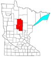 | ||||
| Surrounding communities |
| ||||
| Counties | |||||
† indicates a county seat. ‡ indicates that it is partially in the micropolitan area. § indicates a CDP. | |||||
Authority control | |
|---|---|
| General | |
| National libraries | |
| Other | |
На других языках
[de] Cass County (Minnesota)
Das Cass County[1] ist ein County im US-amerikanischen Bundesstaat Minnesota. Im Jahr 2010 hatte das County 28.567 Einwohner und eine Bevölkerungsdichte von 5,5 Einwohnern pro Quadratkilometer.[2] Der Verwaltungssitz (County Seat) ist Walker.[3]- [en] Cass County, Minnesota
[ru] Касс (округ, Миннесота)
Касс (англ. Cass County) — округ в штате Миннесота, США. Столица и крупнейший город — Уокер. По переписи 2000 года в округе проживают 27 150 человек. Площадь — 6253 км², из которых 5225,6 км² — суша, а 1027,4 км² — вода. Плотность населения составляет 5 чел./км².Другой контент может иметь иную лицензию. Перед использованием материалов сайта WikiSort.org внимательно изучите правила лицензирования конкретных элементов наполнения сайта.
WikiSort.org - проект по пересортировке и дополнению контента Википедии