world.wikisort.org - USA
Merrifield is an unincorporated community and census-designated place (CDP) in Lake Edward Township, Crow Wing County, Minnesota, United States, near Brainerd. It is along Crow Wing County Road 3 near County Road 127. Its population was 140 as of the 2010 census.[3]
Merrifield | |
|---|---|
Census-designated place (CDP) and Unincorporated community | |
 Merrifield Location of the community of Merrifield within Lake Edward Township, Crow Wing County | |
| Coordinates: 46°27′54″N 94°10′22″W | |
| Country | United States |
| State | Minnesota |
| County | Crow Wing |
| Township | Lake Edward Township |
| Area | |
| • Total | 0.54 sq mi (1.41 km2) |
| • Land | 0.54 sq mi (1.41 km2) |
| • Water | 0.00 sq mi (0.00 km2) |
| Elevation | 1,221 ft (372 m) |
| Population (2020) | |
| • Total | 140 |
| • Density | 257.83/sq mi (99.59/km2) |
| Time zone | UTC-6 (Central (CST)) |
| • Summer (DST) | UTC-5 (CDT) |
| ZIP code | 56465 |
| Area code | 218 |
| GNIS feature ID | 647778[2] |
Demographics
| Historical population | |||
|---|---|---|---|
| Census | Pop. | %± | |
| 2020 | 140 | — | |
| U.S. Decennial Census[4] | |||
History
A post office called Merrifield has been in operation since 1899.[5] The community was named for the original owner of the town site.[6]
Education
It is in Brainerd Public Schools.[7] The zoned high school is Brainerd High School.
References
- "2020 U.S. Gazetteer Files". United States Census Bureau. Retrieved July 24, 2022.
- U.S. Geological Survey Geographic Names Information System: Merrifield, Minnesota
- "U.S. Census website". United States Census Bureau. Retrieved 2011-05-14.
- "Census of Population and Housing". Census.gov. Retrieved June 4, 2016.
- "Crow Wing County". Jim Forte Postal History. Retrieved 10 May 2015.
- Warren Upham (1920). Minnesota Geographic Names: Their Origin and Historic Significance. Minnesota Historical Society. p. 158.
- "2020 CENSUS - SCHOOL DISTRICT REFERENCE MAP: Crow Wing County, MN" (PDF). U.S. Census Bureau. Retrieved 2021-07-07.
Municipalities and communities of Crow Wing County, Minnesota, United States | ||
|---|---|---|
County seat: Brainerd | ||
| Cities |  | |
| Townships | ||
| Unorganized territories |
| |
| CDP | ||
| Unincorporated communities | ||
| Indian reservation |
| |
| Ghost towns |
| |
| Footnotes | ‡This populated place also has portions in an adjacent county or counties | |
| ||
Cities in the Brainerd Lakes area, Minnesota | |||||
|---|---|---|---|---|---|
| Core City | 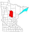 | ||||
| Surrounding communities |
| ||||
| Counties | |||||
† indicates a county seat. ‡ indicates that it is partially in the micropolitan area. § indicates a CDP. | |||||
На других языках
[de] Merrifield (Minnesota)
Merrifield ist eine Siedlung auf gemeindefreiem Gebiet im Crow Wing County im nördlichen Zentrum des US-amerikanischen Bundesstaates Minnesota. Zu statistischen Zwecken ist der Ort zu einem Census-designated place (CDP) zusammengefasst worden. Im Jahr 2010 hatte Merrifield 140 Einwohner.[1]- [en] Merrifield, Minnesota
Текст в блоке "Читать" взят с сайта "Википедия" и доступен по лицензии Creative Commons Attribution-ShareAlike; в отдельных случаях могут действовать дополнительные условия.
Другой контент может иметь иную лицензию. Перед использованием материалов сайта WikiSort.org внимательно изучите правила лицензирования конкретных элементов наполнения сайта.
Другой контент может иметь иную лицензию. Перед использованием материалов сайта WikiSort.org внимательно изучите правила лицензирования конкретных элементов наполнения сайта.
2019-2026
WikiSort.org - проект по пересортировке и дополнению контента Википедии
WikiSort.org - проект по пересортировке и дополнению контента Википедии