world.wikisort.org - Canada
St. Catharines is the largest city in Canada's Niagara Region and the sixth largest urban area in the province of Ontario. As of 2016, it has an area of 96.13 square kilometres (37.12 sq mi), 136,803 residents, and a metropolitan population of 406,074. It lies in Southern Ontario, 51 kilometres (32 mi) south of Toronto across Lake Ontario, and is 19 kilometres (12 mi) inland from the international boundary with the United States along the Niagara River. It is the northern entrance of the Welland Canal. Residents of St. Catharines are known as St. Catharinites. St. Catharines carries the official nickname "The Garden City" due to its 1,000 acres (4 km2) of parks, gardens, and trails.
This article needs additional citations for verification. (June 2022) |
St. Catharines | |
|---|---|
City (lower-tier) | |
| City of St. Catharines | |
 Downtown St. Catharines | |
 Flag  Coat of arms Logo | |
| Nickname(s): The Garden City, St. Kitts, St. Cats, The Kitts | |
| Motto(s): Industry and Liberality | |
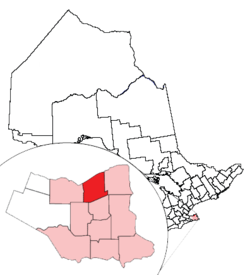 Location of St. Catharines and its census metropolitan area in Ontario | |
 St. Catharines Location of St. Catharines in Southern Ontario | |
| Coordinates: 43°09′30″N 79°14′45″W | |
| Country | Canada |
| Province | Ontario |
| Region | Niagara |
| Settled | 1779 |
| Incorporated (town) | 1845 |
| Incorporated (city) | 1876 |
| Government | |
| • Mayor | Walter Sendzik |
| • Governing body | St. Catharines City Council |
| • MPs | Chris Bittle, Vance Badawey, Dean Allison |
| • MPPs | Jennie Stevens, Jeff Burch, Sam Oosterhoff |
| Area | |
| • Land | 96.13 km2 (37.12 sq mi) |
| • Urban | 378.68 km2 (146.21 sq mi) |
| • Metro | 1,397.51 km2 (539.58 sq mi) |
| Elevation | 97.80 m (320.87 ft) |
| Population | |
| • City (lower-tier) | 136,803 (Ranked 42nd) |
| • Density | 1,384.8/km2 (3,587/sq mi) |
| • Urban | 309,319 (Ranked 17th) |
| • Urban density | 816.8/km2 (2,116/sq mi) |
| • Metro | 406,074 (Ranked 13th) |
| • Metro density | 280.6/km2 (727/sq mi) |
| Time zone | UTC−5 (Eastern (EST)) |
| • Summer (DST) | UTC−4 (EDT) |
| Forward Sortation Area | L2M to L2W |
| Area code(s) | 905, 289, 365, and 742 |
| Highways | |
| GDP (St. Catharines–Niagara CMA) | CA$15.2 billion (2016)[6] |
| GDP per capita (St. Catharines–Niagara CMA) | CA$37,505 (2016) |
| Website | stcatharines |
St. Catharines is between the Greater Toronto and Hamilton Area (GTHA) and the Canada–U.S. border at Fort Erie. Manufacturing is the city's dominant industry, as noted by the heraldic motto, "Industry and Liberality". General Motors of Canada, Ltd., the Canadian subsidiary of General Motors, was the city's largest employer, a distinction now held by the District School Board of Niagara. THK Rhythm Automotive, formerly TRW, operates a plant in the city, although in recent years, employment there has shifted from heavy industry and manufacturing to services.
St. Catharines lies on one of the main telecommunications backbones between Canada and the United States, and as a result a number of call centres operate in the city. It is designated an Urban Growth Centre by the Growth Plan for the Greater Golden Horseshoe, intended to achieve a minimum density target of 150 jobs and residents combined per hectare by 2032 or earlier.[7]
History
The city was first settled by Loyalists in the 1780s. The Crown granted land in compensation for services and for losses in the United States. Early histories credit loyalists Serjeant Jacob Dittrick and Private John Hainer as among the first settlers to come to the area in 1790.[8] They took their Crown Patents where Dick's Creek and 12 Mile Creek merge, now the city centre of St. Catharines. Historians have speculated that Dick's Creek was named after Richard Pierpoint, a Black Loyalist and former American slave, due to an oral history account and events that had taken place around that time that would be consistent with Pierpoint being the source of the name.[9] Secondary to water routes, indigenous trails provided transportation networks, which resulted in the nearby radial road patterns.[10] The surrounding land was surveyed and Townships created between 1787 and 1789.
After the Butler's Rangers disbanded in 1784 and settled the area, Duncan Murray as a former Quartermaster in the 84th Regiment of Foot (Royal Highland Emigrants) was appointed by the Crown to distribute free Government supplies (victuals) for 2 years to the resettled Loyalists.[11] He did this from his mill, built on the 12 Mile Creek in Power Glen. After his death in 1786, his holdings were forfeited to merchant Robert Hamilton of Queenston. Hamilton tried to operate for profit the already well-established Murray's Distribution Centre and Mill under the management of his cousin. Among other ventures, Hamilton became land wealthy, expropriating lands from subsistence Loyalist settlers who were incapable of settling their debts.[12] Murray's distribution centre, later Hamilton's warehouse, and its location have long been a mystery. Hamilton's major profits were derived from transhipping supplies for the military and civic establishments from his Queenston enterprise, not from charitably supplying the subsistence Loyalist settlers. Hamilton lacked interest in social development[13] and sold his business to Jesse Thompson before the turn of the 19th century.

The Merritt family arrived after this time, among the later Loyalists to relocate following the American Revolution. They were from the Carolinas, New York state and New Brunswick. In 1796, Thomas Merritt arrived to build on his relationship with his former Commander and Queen's Ranger, John Graves Simcoe, now the Lieutenant Governor of Upper Canada.[14] The first Welland Canal was constructed from 1824 to 1833 behind what is now known as St. Paul Street, using Twelve Mile and Dick's Creek. William Hamilton Merritt worked to promote the ambitious venture, both by raising funds and by enlisting government support. The canal established St. Catharines as the hub of commerce and industry for the Niagara Peninsula. Merritt played a role in making St. Catharines a centre of abolitionist activity. In 1855, the British Methodist Episcopal Church, Salem Chapel was established at the corner of Geneva and North streets, on land granted to the congregation by Merritt in the early 1840s. The area became known to refugee slaves from the United States as a place of "refuge and rest"; it was a destination, one of the final stops in Canada on the Underground Railroad for refugee African-American slaves. During this time, abolitionist Harriet Tubman lived in St. Catharines.[15][16] By the mid-1850s, the town's population was about six thousand, 800 of whom were of African descent.[17] St. Catharines remains an important place in Black Canadian history.
At an unknown early date, an inn was built by Thomas Adams on the east side of what is now Ontario Street. It became a community meeting place, election centre, stagecoach stop, and mail delivery deposit. This was preceded by the church and a log school house completed before 1797,[18] all on the east bank of the 12 Mile Creek at the extreme west end of what was known at that time as Main Street. This was an extension of the old Iroquois Trail and was renamed St. Paul Street by the settlers and descendant by the mid-19th century. Several mills, salt works, numerous retail outlets, a ship building yard, distillery and various other businesses were developed next.
Incorporated as a village in 1845, St. Catharines had a population of about 3500 in 1846. The primary industry was flour milling. Other industry included ship repairs, four grist mills, a brewery, three distilleries, a tannery, a foundry, a machine and pump factory. There were a variety of tradesmen, three bank agencies, and eight taverns. Stage coaches offered service to other towns and villages. There were already six churches or chapels, a post office that received mail daily, a grammar school and a weekly newspaper.[19]
St. Catharines was incorporated as a city in 1876.[20] The city expanded when it annexed Grantham Township, Merritton, and Port Dalhousie. There was some westward expansion, which was divided between St. Catharines and Lincoln.[21]
Origin of the name
Before it was called St. Catharines, the settlement near Twelve Mile Creek was known by various names, including Shipman's Corners and The Twelve.[14] The name St. Catharines was first recorded in 1796 (as St. Catherines) and became a common name for the settlement by 1809—though it would often be spelled with an -er, or with an apostrophe before the s.[22] The name and the spelling was standardized as St. Catharines when the town incorporated in 1845.[23] It is not clear which Catherine the city is named after. Common theories include Saint Catherine of Alexandria,[24] Catherine Butler (wife of Colonel John Butler),[25] or Catherine Askin Hamilton (wife of Robert Hamilton).[26] Catharine Rodman Prendergast Merritt, wife of William Hamilton Merritt, may be the source of the -ar spelling.[22] An alternate theory to explain the spelling was that Catharine with an -ar was the typical spelling of the name for Palatine German settlers in the region.[27]
Geography
Climate
St. Catharines' climate is humid continental (Köppen borderline Dfa/Dfb).[28] It has a unique micro-climate because of the moderating influence of Lake Ontario/Lake Erie and the sheltering effect of the Niagara Escarpment to the south. This climate allows wineries to flourish.[29] As a result, the city records numerous frost-free days and frequent thaws in the winter, although it sometimes receives heavy lake-effect snow during certain wind conditions, and micro-cooling lakeside on some spring afternoons. The summer season is predominantly warm, sometimes hot and humid, with an average high temperature of 27 °C (81 °F) in July. Summer thunderstorms are commonplace but generally less prevalent and less severe than further west in southern Ontario due to the diminishing effect of the surrounding lakes.
The highest temperature ever recorded in St. Catharines was 40.0 °C (104 °F) on 10 July 1936.[30] The coldest temperature ever recorded was −25.7 °C (−14.3 °F) on 18 February 1979.[31]
| Climate data for St. Catharines Airport, 1981–2010 normals, extremes 1911–present[lower-alpha 1] | |||||||||||||
|---|---|---|---|---|---|---|---|---|---|---|---|---|---|
| Month | Jan | Feb | Mar | Apr | May | Jun | Jul | Aug | Sep | Oct | Nov | Dec | Year |
| Record high humidex | 20.8 | 20.2 | 29.3 | 34.5 | 43.5 | 44.5 | 46.1 | 49.4 | 42.0 | 39.0 | 27.1 | 25.0 | 49.4 |
| Record high °C (°F) | 20.0 (68.0) |
19.4 (66.9) |
26.7 (80.1) |
32.2 (90.0) |
35.0 (95.0) |
36.1 (97.0) |
40.0 (104.0) |
38.3 (100.9) |
36.7 (98.1) |
31.1 (88.0) |
26.8 (80.2) |
21.9 (71.4) |
40.0 (104.0) |
| Average high °C (°F) | −0.3 (31.5) |
0.9 (33.6) |
5.5 (41.9) |
12.4 (54.3) |
19.5 (67.1) |
24.4 (75.9) |
27.1 (80.8) |
25.8 (78.4) |
21.6 (70.9) |
15.1 (59.2) |
8.4 (47.1) |
2.5 (36.5) |
13.6 (56.5) |
| Daily mean °C (°F) | −3.8 (25.2) |
−2.9 (26.8) |
1.1 (34.0) |
7.4 (45.3) |
13.7 (56.7) |
19.0 (66.2) |
21.9 (71.4) |
20.8 (69.4) |
16.6 (61.9) |
10.4 (50.7) |
4.6 (40.3) |
−0.9 (30.4) |
9.0 (48.2) |
| Average low °C (°F) | −7.4 (18.7) |
−6.8 (19.8) |
−3.3 (26.1) |
2.2 (36.0) |
7.9 (46.2) |
13.4 (56.1) |
16.6 (61.9) |
15.7 (60.3) |
11.6 (52.9) |
5.6 (42.1) |
0.8 (33.4) |
−4.2 (24.4) |
4.4 (39.9) |
| Record low °C (°F) | −23.8 (−10.8) |
−25.7 (−14.3) |
−21.1 (−6.0) |
−15 (5) |
−4.4 (24.1) |
1.0 (33.8) |
6.1 (43.0) |
2.6 (36.7) |
0.0 (32.0) |
−7 (19) |
−13.9 (7.0) |
−24.4 (−11.9) |
−25.7 (−14.3) |
| Record low wind chill | −42.0 | −34.6 | −28.3 | −19.7 | −2.9 | 0.0 | 0.0 | 0.0 | 0.0 | −8.3 | −18.9 | −28.0 | −42.0 |
| Average precipitation mm (inches) | 65.2 (2.57) |
54.9 (2.16) |
61.7 (2.43) |
77.0 (3.03) |
76.8 (3.02) |
85.9 (3.38) |
77.8 (3.06) |
70.3 (2.77) |
90.6 (3.57) |
67.0 (2.64) |
81.6 (3.21) |
71.5 (2.81) |
880.1 (34.65) |
| Average rainfall mm (inches) | 30.8 (1.21) |
28.9 (1.14) |
39.3 (1.55) |
71.2 (2.80) |
76.3 (3.00) |
86.0 (3.39) |
77.8 (3.06) |
70.3 (2.77) |
90.6 (3.57) |
67.0 (2.64) |
72.1 (2.84) |
44.0 (1.73) |
754.2 (29.69) |
| Average snowfall cm (inches) | 38.6 (15.2) |
29.3 (11.5) |
23.2 (9.1) |
5.8 (2.3) |
0.4 (0.2) |
0.0 (0.0) |
0.0 (0.0) |
0.0 (0.0) |
0.0 (0.0) |
0.1 (0.0) |
9.6 (3.8) |
30.1 (11.9) |
137.1 (54.0) |
| Average precipitation days (≥ 0.2 mm) | 16.5 | 13.4 | 13.3 | 13.9 | 11.5 | 10.9 | 9.8 | 9.7 | 10.9 | 11.8 | 14.1 | 15.2 | 150.7 |
| Average rainy days (≥ 0.2 mm) | 5.8 | 5.8 | 8.4 | 12.4 | 11.5 | 10.9 | 9.8 | 9.7 | 10.9 | 11.8 | 12.1 | 8.1 | 117.0 |
| Average snowy days (≥ 0.2 cm) | 12.3 | 9.1 | 6.5 | 2.4 | 0.05 | 0.0 | 0.0 | 0.0 | 0.0 | 0.10 | 3.0 | 9.4 | 42.7 |
| Average relative humidity (%) | 73.0 | 67.7 | 62.9 | 57.6 | 55.9 | 58.1 | 57.5 | 59.0 | 60.5 | 64.5 | 69.1 | 71.9 | 63.1 |
| Mean monthly sunshine hours | 64.5 | 106.8 | 140.5 | 166.5 | 242.3 | 279.9 | 277.6 | 255.3 | 185.0 | 155.2 | 80.5 | 69.3 | 2,023.4 |
| Percent possible sunshine | 22.2 | 36.2 | 38.1 | 41.5 | 53.3 | 60.9 | 59.6 | 59.1 | 49.2 | 45.2 | 27.5 | 24.7 | 43.1 |
| Source: Environment Canada[31][32][30] | |||||||||||||
The complex and extensive glacial history of the Niagara Peninsula has resulted in similarly complex soil stratigraphy in the area occupied by the city today. St. Catharines was once at the base of a glacial lake known as Glacial Lake Iroquois, which deposited thick layers of clay between the Escarpment and Lake Ontario. As a result of these factors, the city's soil is particularly conducive to fruit growing and is capable of producing grapes that are used to make award-winning wines. Three wineries operate in the city's west end: Henry of Pelham Winery, Hernder Estates and Harvest Estates.
Since the opening of the first Welland Canal in 1829, the city has had four different canal systems, whether modified or newly constructed, carved into its geographical landscape. The fourth and present-day canal forms the majority of the city's eastern boundary. The first three of the city's canals have largely been buried, portions of it beside the present-day Highway 406 and near Lake Street and the QEW highway. Other remnants of the original canals can still be seen in various locations throughout the city; many remains are hidden within forested areas designated as city parks. Some residents in the region are interested in restoring the original routing of the Welland Canal through the city. They intend that the restored waterway and locks would be open to a new tourist attraction within the city.
St. Catharines was affected by the Blizzard of 1977, an event which resulted in more than 150 cm of snow, wind that travelled the speed of 110km/h, and a wind chill of approximately -45 degrees Celsius. The Queen Elizabeth Way (QEW) was closed and a state of emergency was declared. The Canadian Armed Forces was involved in rescue efforts.[33]
Communities
St. Catharines' development history has resulted in a number of unique and distinct communities within the city. The historical area of St. Catharines consisted of nothing more than what is now the downtown core, with the remaining land being part of Louth Township on the west and Grantham Township on the east. St. Catharines continued to steadily grow through the late 19th and early 20th centuries, eventually annexing land to the southwest that would become Western Hill and Old Glenridge, and to the east and north that would collectively become the central part of St. Catharines. In addition to the growth of St. Catharines, the town of Merritton and the town of Port Dalhousie existed as separate municipalities to the south and north of the city, each slowly growing their own residential base.
Along with the rest of Ontario, St. Catharines experienced explosive growth after World War II. St. Catharines continued to annex Grantham Township as development continued, including the large swaths of land to the north known now as "The North End". St. Catharines would also absorb Merritton and Port Dalhousie in 1961, making them part of the city. During this time, St. Catharines nearly tripled in population.
With the formation of the Regional Municipality of Niagara in 1970, the portion of Louth Township east of Fifteen Mile Creek was transferred to the City of St. Catharines. This included the eastern portion of the Hamlet of Rockway, as well as the Hamlet of Power Glen. The few remaining portions of Grantham Township in the Northeast corner of the area, including Port Weller, were also transferred to the city. With the new Louth Township lands belonging to the city, St. Catharines would begin two developments in the west end — Martindale Road in 1983, and Vansickle Road in 1987. These developments are nearing completion. There was also a push to continue further expansion to the west in the late 1990s, but this has since been halted by Ontario Greenbelt legislation.
The following distinct communities exist within St. Catharines:
- North
- Bunting
- Facer
- Lancaster
- Michigan Beach
- The North End
- Port Dalhousie
- Port Weller
- Central
- Fitzgerald
- Haig
- Orchard Park
- Queenston
- Downtown St. Catharines
- West
- Martindale
- Power Glen
- Vansickle
- Western Hill
- East
- Kernahan
- Lock 3
- Merritton
- Oakdale
- Secord Woods
- South
- Barbican Heights
- Brockview
- Glenridge
- Marsdale
- Riverview
- Louth Agricultural Lands
Downtown

Numerous efforts have been made to improve the downtown; the restructuring of manufacturing resulted in a loss of jobs and retail businesses. In the early 21st century, city, university, and private developers undertook several initiatives to revive downtown, related to urban design, clustering activities to attract people to the area as a destination from day through evening events.
In 2006, city council approved converting one-way arteries through the city centre to allow for two-way traffic, to make it easier for people to make their way around the city to explore it. In terms of urban planning and use, two-way traffic improves circulation within the area. The city wanted to improve downtown as a destination, rather than a place to pass through. The council also want to have downtown St. Catharines on the Wine Route, a driving tour of Niagara wineries and an Ontario Wine Council initiative to boost the number of visitors to the region's many wineries.[34] The Wine Route was modified to officially redirect winery goers through the downtown starting in 2012.[35] The first phase of two-way traffic was completed in 2009, with St. Paul and King streets being converted. The cost of the conversion was $3.5 million and was shared with Niagara Region.[36] In 2012, most observers concluded that the change had achieved its goals; it garnered national media attention.[37]
In 2009, $54 million in joint federal, provincial and municipal funding was announced for the construction of a performing arts centre in the city's core, officially opened in September 2015 as the FirstOntario Performing Arts Centre. Complementing the centre, which features concert, dance and film venues, is Brock University's Marilyn I. Walker School of Fine and Performing Arts. The university renovated the former Canada Hair Cloth Building to use for the school. This former industrial building is behind St. Paul Street and next to the municipal performing arts centre.[38]
In late 2011, city council approved moving forward with the construction of a new spectator facility to replace the crumbling Gatorade Garden City Complex, built in 1938. Council voted to build a U-shaped facility, which will be home to the Niagara IceDogs, an Ontario Hockey League team, and be able to host other events, such as concerts. It would have room for 4,500 to 5,300 spectators. The goal is to keep the cost of the facility at or below $50 million and to build it on a swath of land known locally as the lower-level parking lot, behind St. Paul Street and abutting Highway 406.[39] Council's commitment to build the facility resulted in IceDogs' owner Bill Burke promising to sign a 20-year lease with the city after he threatened to move his team if the city chose not to build a new arena.[40]
The city has made other infrastructure improvements to the downtown. In January 2012, a new edition of the Carlisle Street Parking Garage opened. It was built to Leadership in Energy and Environmental Design standards and was certified for its environmentally friendly features, including a green roof, preferred carpool and hybrid vehicle parking, greywater collection, permeable interlocking brick pavement, and several bike racks for users. A mixed-use development, the structure was planned for retail space at street level on Carlisle Street, in order to promote activity and business on the street. The project cost $27.9 million, with funding split three ways between the federal, provincial and municipal governments.[41] Starting in 2019, certain streets located in downtown St. Catharines have been closed during weekends to vehicle traffic. These pedestrian zones have expanded over time. $214,500 was allocated in the cities budget in 2021 for these road closures.[42]
Demographics
| Year | Pop. | ±% |
|---|---|---|
| 1841 | 3,500 | — |
| 1871 | 7,864 | +124.7% |
| 1881 | 9,631 | +22.5% |
| 1891 | 9,170 | −4.8% |
| 1901 | 9,946 | +8.5% |
| 1911 | 12,484 | +25.5% |
| 1921 | 19,881 | +59.3% |
| 1931 | 24,753 | +24.5% |
| 1941 | 30,025 | +21.3% |
| 1951 | 37,984 | +26.5% |
| 1961 | 84,472 | +122.4% |
| 1971 | 109,722 | +29.9% |
| 1981 | 124,018 | +13.0% |
| 1991 | 129,300 | +4.3% |
| 1996 | 130,926 | +1.3% |
| 2001 | 129,170 | −1.3% |
| 2006 | 131,989 | +2.2% |
| 2011 | 131,400 | −0.4% |
| 2016 | 133,113 | +1.3% |
| 2021 | 136,803 | +2.8% |
In the 2021 Census of Population conducted by Statistics Canada, St. Catharines had a population of 136,803 living in 58,903 of its 61,977 total private dwellings, a change of 2.8% from its 2016 population of 133,113. With a land area of 96.2 km2 (37.1 sq mi), it had a population density of 1,422.1/km2 (3,683.1/sq mi) in 2021.[43]
At the census metropolitan area (CMA) level in the 2021 census, the St. Catharines - Niagara CMA had a population of 433,604 living in 179,224 of its 190,878 total private dwellings, a change of 6.8% from its 2016 population of 406,074. With a land area of 1,397.09 km2 (539.42 sq mi), it had a population density of 310.4/km2 (803.8/sq mi) in 2021.[44]
As of the 2016 Canadian census, 84.7% of the population is White. Other groups include Black: 2.9%, Indigenous: 2.6%, Chinese: 2.1%, Latin American: 1.7%, and South Asian: 1.4%.[45]
Since 1998, St. Catharines has had one of the highest obesity rates of any centre in Canada. A 2001 analysis by Statistics Canada showed that 57.3 percent of its residents were overweight.[46] This has caused some elements of the media, including CTV,[46] the Canadian Broadcasting Corporation[47][48] and The Globe and Mail to dub St. Catharines as Canada's "fattest" city.[49] In 2008, new statistics were released that show that the percentage obese or obese/overweight residents of Hamilton (74.3%), Kingston (70.1%), and St. John's, Newfoundland and Labrador (70%) is now higher than St. Catharines-Niagara (69.3%), though the obesity rate in St. Catharines was higher in 2008 than in 1998.[50]
23% of children in St. Catharines were estimated to be living in poverty as of 2015, which was above Canada's average rate of child poverty.[51] In 2022, the municipality itself as an employer became the largest in Ontario to offer a living wage, an action praised by the Niagara Poverty Reduction Network.[52]
Economy

Tourism was considered to be an influential factor in Conference Board of Canada's projected GDP growth for St. Catharines.[53] The city is approximately 20 km from the U.S.–Canada border. Its economy is affected by the millions of tonnes of cargo shipped through the Welland Canal, with the locks for the canal being considered a tourist attraction by itself. St. Catharines was the location of a transmission plant for General Motors.[54] The 20 hectare property where the factory once operated is now classified as a contaminated brownfield.[55]
Arts and culture
Theatre
St. Catharines is also home to a variety of theatre companies. These companies include Garden City Productions (formerly the Operatic Society of Grantham United Church 1956–1962), Carousel Players (in the Old Courthouse), Mirror Theatre, Essential Collectives Theatre, and the Empty Box Theatre Company. In 2015, the FirstOntario Performing Arts Centre opened.[56] In 2016, the Film House launched within the space, featuring cinema screenings with themed or genre-specific nights.[57]
Events
The Grape and Wine Festival Parade is held annually each September. More than 100,000 people were anticipated for the 2022 event.[58]
The International Chicken Chucking Championships takes place every January in the St. Catharines neighbourhood of Port Dalhousie and attracts hundreds of participants and observers.[59] Chicken Chucking consists of pitching or sliding frozen chickens along the ice-covered Martindale Pond and is hosted by the Kilt and Clover. Animal rights groups such as Niagara Action for Animals have protested the event.[60] Proceeds from the event are donated to Community Care, a local food bank.[61]
St. Catharines was one of the cities that hosted the 2022 Canada Summer Games. More than 5,000 athletes and coaches arrived for the games, which took place from August 6 to August 21, 2022. The opening ceremony was held at the Meridian Centre.[62]
Attractions

- Burgoyne Bridge – a bridge in downtown St. Catharines
- Garden City Skyway – QEW crossing over the Welland Canal
- Lakeside Park Carousel – historic carousel located in Port Dahousie
- Merritton Tunnel
- Morningstar Mill – heritage site and mill
- Pen Centre – a regional shopping centre
- The St. Catharines Armoury is a recognized Federal Heritage building, #1991 on the Register of the Government of Canada Heritage Buildings.[63]
- The St. Catharines Museum is at Lock 3 on the Welland Canal, off the Welland Canals Parkway. An elevated viewing platform at the museum allows visitors to get a close-up look at international ships crossing this section of the St. Lawrence Seaway. Along with its exhibits dedicated to the city's history and the canals, the museum is home to the Ontario Lacrosse Hall of Fame and Museum.
Parks
- Montebello Park: Designed by Frederick Law Olmsted in 1887, who was renowned for designing and developing New York City's Central Park in 1853. A commemorative rose garden, with over 1,300 bushes in 25 varieties, is the city's largest rose collection; it features an ornamental fountain. The focal point of the park is a band shell and pavilion built in 1888. The park is designated under the Ontario Heritage Act.
- Lakeside Park: Located in the North end, along the shores of Lake Ontario in the community known as Port Dalhousie. Hosts yearly fireworks displays on 1 July (Canada Day). Has picnic areas, a pavilion, snack bar, change rooms, washrooms, playground equipment, boardwalk, the Lakeside Park Carousel, and public docks for visiting boaters. The beach offers magnificent sunset views over Lake Ontario. Lakeside Park inspired a song by the rock band Rush which describes the park itself and drummer/lyricist Neil Peart's memories there.[64]
- Burgoyne Woods: A 50-hectare (0.5 km2) wooded area and recreational park near the Downtown core. It also contains a dog park and is the host of annual cross country races within the District School Board of Niagara (DSBN) and the Niagara Catholic District School Board (NCDSB).
- Happy Rolph's Bird Sanctuary: A 6-hectare (0.06 km2) park on the shores of Lake Ontario in the community of Port Weller. It is home to hundreds of native and migratory birds and features an exotic collection of flowering rhododendrons. An onsite petting farm (containing horses, pigs, sheep, goats and llamas, as well as a donkey named 'Hoti'—'Don Quixote') is operated by the city from Victoria Day to Thanksgiving weekend. A trail running throughout the park leads to a peaceful waterfront memorial to Canadian victims of the 9/11 terrorist attacks.
- Ontario Jaycee Gardens: Overlooking the Henley Rowing Course, this is the city's largest horticultural park, with more than 8 hectares (0.08 km2) of meticulously landscaped gardens and flower displays. Among the displays is a memorial site dedicated to Kristen French. The park exists on land that once featured the Third Welland Canal. The former entrance to the canal can still be seen at the north-west end of the park.
- Walker Arboretum: Located along the hillside of Rodman Hall and the Twelve Mile Creek below, the original owner of this estate was Thomas Rodman Merritt, son of William Hamilton Merritt. In the late 19th century, an English landscape designer named Samuel Richardson was hired by Merritt to tend the grounds. As a result, the arboretum is an extensive, rambling garden with rare conifers which benefit from an exceptional micro-climate. It boasts one of the largest Chinese Empress trees in Canada.
- Woodgale Park: Located along Glendale Avenue between Glenridge Avenue and the Pen Centre. Features wide open spaces, flowing fruit trees, rare birds, a soccer field and tennis courts. Also features a memorial to the original farm building on the north end of the park near Denis Morris Catholic High School. Locally known as Doug Hill Park, after a nearby resident who coached a number of baseball and tug of war teams in this area.
Trail system

The city's trail system offers over 90 kilometres (55 mi) of accessible pathways that are suitable for walking, jogging, cycling, hiking and cross-country skiing.
- Bruce Trail: Canada's oldest and longest hiking trail, following the Niagara Escarpment (designated as a UNESCO World Biosphere Reserve site) from Niagara-on-the-Lake to Tobermory. A 20-kilometre (12 mi) section with associated side trails winds through St. Catharines passing by places such as the Morningstar Mill.
- Merritt Trail: a segmented 11 km (6.8 mi) trail that passes many of the old sections of the second Welland Canal and remnants of its locks.
- Laura Secord Legacy Trail – a trail that was established to commemorate Laura Secord's 32 km walk to warn of an upcoming American attack during the War of 1812.[65]
- Terry Fox Trail: a 1.5 km trail that runs along Carlon Street and Geneva Street. Six exercise stations are placed throughout it.[66]
- Waterfront Trail: follows the shore of Lake Ontario, connecting communities from Niagara-on-the-Lake to Brockville. The Port Dalhousie portion of the trail is a major highlight.
- Welland Canals Parkway Trail – The trail in its entirety is 45 km, stretching from St. Catharines to Port Colborne.[67]
Sports
Ice hockey
St. Catharines entered into the Ontario Hockey Association Junior 'A' Hockey in 1943 as the St. Catharines Falcons. In 1947, they became the Teepees and were affiliated with the American Hockey League's Buffalo Bisons. When the National Hockey League's (NHL) Chicago Blackhawks made the Bisons their number one farm team, they inherited the Teepees. In the 1960s, the Jr. 'A' team went deeply into debt to the Chicago Black Hawks, but continued as a successful franchise and were named the St. Catharines Black Hawks. The Hamilton Fincups moved to St. Catharines in 1976 and played here for one year before moving back to Hamilton. The AHL St. Catharines Saints played in St. Catharines between 1982 and 1986, before being forced to re-locate to Newmarket due to protests from the NHL Buffalo Sabres. The St. Catharines Saints served as the farm team for the Toronto Maple Leafs, and today are known as the Toronto Marlies.
In 2007, the OHL's Mississauga IceDogs relocated to St. Catharines and became the Niagara IceDogs. The IceDogs played out of the Jack Gatecliff Arena, which was renamed the Gatorade Garden City Complex. In 2014, the IceDogs moved to the newly built Meridian Centre. Since starting out the team has won the Emms Trophy in 2010–2011 & 2018–2019. They have also won the Bobby Orr Trophy during 2011–2012 season and 2015–2016 season, qualifying for the OHL Finals. They would be beaten both times by the London Knights. The team has had numerous NHL alumni including Alex Pietrangelo, Dougie Hamilton, Vince Dunn, Ryan Strome, Akil Thomas and Mark Visentin.
The St. Catharines Falcons play in the Golden Horseshoe Division of the Greater Ontario Junior Hockey League. The team has played since 1968 and plays all home games out of the Jack Gatecliff Arena. The team were runners up for the Sutherland Cup in 1979, 1990, 1994, 1997, 2000 and 2014, but won the cup in 2012.
Basketball
In 2015, the National Basketball League of Canada announced that Niagara had been awarded a new franchise to play in the Meridian Centre. The team, named the Niagara River Lions, began play in 2015 where they reached the conference quarterfinals. The team joined the Canadian Elite Basketball League after the 2017–18 season. In 2021, the River Lions had one of their best seasons, finishing 2nd with a 10-4 record. The River Lions made it through the playoffs into the finals, where they lost 65-101 to the Edmonton Stingers.
Baseball
The city was the home of the New York–Penn League's St. Catharines Blue Jays, the Short-season A affiliate of the Toronto Blue Jays, from 1986 to 1999. In 1996 the team was renamed the St. Catharines Stompers, and was subsequently sold and relocated to Queens, New York City in late 1999, where they became the Queens Kings.
Rugby
St. Catharines Tigers RFC was formed in 1978. Beginning in 2015, the Tigers joined the Niagara Wasps RFC and play at their field in Thorold.
Soccer
The Canadian Soccer League's St. Catharines Wolves are one of the most successful professional soccer teams in Canada, and play at Club Roma in the west-end of the city.
Rowing

Martindale Pond in St. Catharines' Port Dalhousie is the site of the annual Royal Canadian Henley Regatta, a world-class event that brings over 3,000 athletes from various nations to the city. The site hosted the FISA World Rowing Championships in 1970 and in 1999. More recently, the World Master's Rowing Championship was held at the Martindale Pond in the summer of 2010, with $500,000 in improvements to the facility such as: a weed harvester, new docking and a new timing system. There are currently talks to bring the Canadian Rowing Hall of Fame to St. Catharines sometime in the near future. The pond is also home to the St. Catharines rowing club, Brock University rowing club, Ridley College rowing club and to the annual CSSRA Championships, which draws hundreds of high school athletes from Canada, the U.S. and Mexico. The Martindale Pond or Henley, continues to hold its world-renowned status as a major rowing venue in the world. The rowing event in the Pan American Games were held in St. Catharines in 2015. Several Olympic medallists in rowing are from St. Catharines, including Melanie Kok, Buffy Williams, and Dave Boyes.
Sailing
There are marinas at Port Dalhousie and Port Weller and a club that sails from Municipal Beach. The St. Catharines Marina is at Port Weller. The Port Dalhousie Pier Marina and the Port Dalhousie Yacht Club are at Port Dalhousie.
Government
Municipal

St. Catharines is governed by a mayor and city council of twelve city councillors, with two councillors representing each of the six municipal wards in the city. A city councillor is also elected by the council as a whole to serve as deputy mayor, who only fills the role should the elected mayor not be available. St. Catharines City Council meets every Monday and is open to participation by the community. Matters put forward are voted on by members of city council; the mayor presides over council debate and serves very much like the speaker, and as a result only votes in the case of a tie. After 2006, municipal elections will be in November every four years rather than the previous three. Unlike most cities its size, city councillors only serve on a part-time basis and continue with their non-political careers in the community. Only the mayor is elected to a full-time position. St. Catharines City Hall is downtown on Church Street. Tim Rigby was the Mayor of St. Catharines from 1997 to 2006; Brian McMullan was elected to succeed Rigby on 13 November 2006, and was sworn in on 4 December. He was re-elected in October 2010.[68] On 27 October 2014, Walter Sendzik was elected mayor of St. Catharines[69] and assumed office in December 2014.[70]
St. Catharines uses a council-manager government, and as a result a chief administrative officer (CAO) is appointed by council to oversee the day-to-day operations of the city and its departments. The CAO, in effect, is the highest ranking municipal civil servant and has authority over the spending of municipal tax dollars. The CAO advises council on policy matters and acts as liaison between the administrative staff and elected officials. Some of the CAOs duties include assisting in the creation of the municipal budget, and ensuring that municipal funds are spent in a responsible manner. Residents of St. Catharines also elect six regional councillors to the Niagara Regional Council on an at-large basis. Unlike many other regional municipalities in Ontario, regional councillors do not sit on city council and instead only represent at the regional level. Four school board trustees for the District School Board of Niagara representing St. Catharines and Niagara-on-the-Lake are elected, as well as three trustees for the Niagara Catholic District School Board, two for five of St. Catharines' wards, and one for Thorold and the Merriton Ward of St. Catharines. Regional councillors and school board trustees are elected at the same time, and on the same ballot, as the mayor and city councillors. St. Catharines has one of the lowest resident/representative ratios of any large city in Ontario. There are just under 7,000 people per elected municipal representative in St. Catharines, while Oshawa (a similar-sized city in Ontario) has one representative per 13,500 people. London, Ontario, has one representative per 30,500 people and Toronto has one representative per 111,774 people. There has been discussion regarding a modification of the city/regional council arrangement, with the possibility of reducing city council to six full-time representatives and having the six regional councillors serve on city council. While there is growing support in the business community for such an arrangement, city council has been unreceptive to such ideas.
Provincial

At the provincial level, St. Catharines is well known for electing high-profile members of the Legislative Assembly of Ontario. Jim Bradley was the Member of Provincial Parliament for St. Catharines from 1977 until 2018 and was Ontario's longest serving MPP.[71] Peter Kormos, who represented the southern portions of the city as part of the Welland riding, was a prominent Member of Provincial Parliament in the Ontario New Democratic Party caucus and served previously as Minister of Consumer and Commercial Relations in the Bob Rae government. From 1999 to 2003, during the premierships of Mike Harris and Ernie Eves, St. Catharines was the only large city in Ontario to not have at least one government member representing the city, as the Progressive Conservative-held ridings of Lincoln and St. Catharines—Brock were eliminated as a cost-saving measure. Robert Welch, a long-time Deputy Premier of Ontario, represented the now-eliminated Lincoln and St. Catharines—Brock ridings throughout the 1960s, 1970s and 1980s.
Federal
Federally, St. Catharines is one of the most bellwether of any riding in Canada, having only elected an opposition MP twice in its history. Chris Bittle is the current MP for St. Catharines and is a member of the Liberal Party of Canada, which currently forms Canada's government. The southern portion of the city is included as part of the Niagara Centre riding, and is represented by Vance Badawey, a Liberal Party of Canada MP.[72] Most federal representatives from St. Catharines have maintained a low profile on either the government or opposition backbenches. The exception was Gilbert Parent, who served as Speaker of the House for seven years while Jean Chrétien was Prime Minister.
Legal
St. Catharines is the judicial seat of the Niagara North Judicial District of Ontario, Central South Region, which represents the northern half of the Niagara Region equivalent to historic Lincoln County. The Superior Court of Justice is on Church Street across from City Hall. A satellite court is in Grimsby. The city forms "1 District" of the Niagara Regional Police Service. The NRPS headquarters are no longer on Church Street, having moved to Niagara Falls in a finally constructed new building with administrative offices and support services on Cushman Road.
Infrastructure
Transportation
The most defining transportation icon of St. Catharines is the Welland Canal, a ship canal that runs 43.4 kilometres (27.0 mi), passing through the city. Four of its locks are within city boundaries. The canal allows shipping vessels to traverse the 99.5-metre (326.5 ft) drop in altitude from Lake Erie to Lake Ontario.
The main access routes into and out of St. Catharines are served by two major freeways. The Queen Elizabeth Way runs east (at 15-Mile Creek) to west (at Garden City Skyway) and Highway 406 runs north (at QEW) to south (at St. David's Road). Prior to the construction of these freeways, St. Paul Street (former Highway 8, now Regional Road 81) and Hartzel Road (former Highway 58, now a city-maintained street) provided east–west and north–south access to the city.
Public transportation is served by the St. Catharines Transit Commission, which operates bus routes throughout the city and neighbouring Thorold. All major routes converge at the St. Catharines Bus Terminal, which is downtown within the headquarters of the Ontario Ministry of Transportation. The central station is also served by Coach Canada, with service to Toronto and Niagara Falls.
Though transportation by rail is becoming increasingly popular, the St. Catharines train station is largely under-utilized, with car and bus travel being the dominant forms of transportation for the city. The station is in its original building, outside the downtown core (because of issues involving the crossing of 12-Mile Creek). It is served daily by Via Rail and Amtrak trains connecting it to Toronto and New York City. The provincial and federal government recently committed $385 million each to GO Transit to aid in the development of their 10-Year Capital Expansion Plan, which includes an expansion bus line servicing the Niagara Region. Currently, regular GO Bus service exists to St. Catharines with a stop at Fairview Mall, allowing riders to travel either west toward Burlington or east toward Niagara Falls. A rail link with GO Transit operates during the summer months with plans for the city to be permanently linked via rail in the future.
St. Catharines/Niagara District Airport services general aviation as well as chartered jetliner flights. The airport is served by charter flights from FlyGTA Airlines and offers charter flights to Billy Bishop Toronto City Airport, Muskoka and Collingwood. It is near the city's east-end in neighbouring Niagara-on-the-Lake. Other airports surrounding the city include Niagara Falls/Niagara South Airport and Niagara Central Dorothy Rungeling Airport. The closest airports in proximity offering long-haul and international flights are John C. Munro Hamilton International Airport, Niagara Falls International Airport and Toronto Pearson International Airport.
St. Catharines had one of the first interurban electric streetcar routes, which ran between the city and Merritton and was eventually extended to Port Dalhousie in the north and Thorold to the south. Like most streetcar routes throughout the world, it was decommissioned in the 1960s, and the right-of-way has since been converted to parks and trails.
Education
Secondary schools
The District School Board of Niagara (DSBN), the local public school board, manages 6 secondary schools within St. Catharines: DSBN Academy, Laura Secord Secondary School, Sir Winston Churchill, Governor Simcoe, St. Catharines Collegiate, and Eden. The opening of DSBN Academy was described as "Canada's most controversial pedagogical experiment in years" by the Globe and Mail, as the school was specifically geared towards low-income students. This raised fears about segregation in public education and causing low-income students to feel singled out. Proponents argued that the additional academic supports offered to disadvantaged students would raise their chances of attending post-secondary education.[73] Governor Simcoe and Winston Churchill offer french immersion programs.[74] Eden Secondary School, although it operates through the DSBN and receives public school funding, is also a Christian school.[75]
The Niagara Catholic District School Board (NCDSB) manages and operates 3 Catholic secondary schools within the city: Holy Cross, Denis Morris Catholic High School, and Saint Francis.
Ridley College, near the city's downtown core in the Western Hill neighbourhood, is a private co-educational boarding and day school. It was established as a boys' school in 1889, and became co-educational in 1973.
Post-secondary
St. Catharines is home to Brock University (established 1964), a modern comprehensive university on the Niagara Escarpment. Concordia Lutheran Theological Seminary, a post graduate institution of the Lutheran Church–Canada, also operates there. A partnership between the university and the Ontario Grape and Wine Industry established the city as a centre for cool-climate grape and wine research.
The Michael G. DeGroote School of Medicine is a medical school operated by McMaster University with a campus in downtown St. Catharines. Prior to 2004, it was known as the McMaster University School of Medicine.[76]
Although not a part of St. Catharines itself, there are nearby campuses for Niagara College in Niagara on the Lake and Welland. The college used to operate a horticulture-related campus in the city on 360 Niagara Street from the 1970s to 1990s.
Media
Newspapers
- St. Catharines Standard (daily)
- Niagara This Week (community weekly)
- The Brock Press (student newspaper for Brock University)[77]
Radio
- AM 610: CKTB, news /talk
- AM 1220: CFAJ, Oldies
- FM 97.7: CHTZ (HTZ FM), active rock
- FM 103.7: CFBU, Brock University campus radio
- FM 105.7: CHRE (Move), adult contemporary
Television
The Niagara region currently has no locally based television service of its own. Stations broadcasting from Toronto, Hamilton and Buffalo are available over-the-air in the region, and the region has a local transmitter (CKVP-DT) rebroadcasting the Barrie CTV 2 station CKVR-DT. A local specialty news and information channel called Niagara News TV launched in February 2011, but ceased operations only 3 months later in April. In 2003, a local business consortium applied to the Canadian Radio-television and Telecommunications Commission (CRTC) for a licence to operate TV Niagara, a community television station in St. Catharines. The application was denied by the CRTC in 2005, citing concerns about the group's business plan and its dependence on gaining audience share in the Toronto market.[78]
Sister cities
 Port of Spain, Trinidad and Tobago[79]
Gallery
 Decew Falls and Morningstar Mill
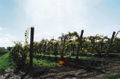 Grapes from a family vineyard near the city's west end
 Lakeport Road, in Old Port Dalhousie
 Montebello Park
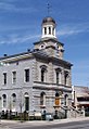 The Old Courthouse, at the corner of James and King streets
 Port Dalhousie Yacht Club West Docks, Waterfront Trail
 The St. Catharines farmers' market


See also
- List of cities in Ontario
- List of people from St. Catharines
- List of mayors of St. Catharines
Notes
- Extreme high and low temperatures were recorded at St. Catharines (January 1911 to May 1971) and at St. Catharines Airport (June 1971 to present).
References
- "St. Catharines, Ontario census profile". 2016 Census of Population. Statistics Canada. Archived from the original on 17 March 2017. Retrieved 4 March 2017.
- "St. Catharines, Ontario (Code 3526053) census profile". 2011 Census of Population. Statistics Canada. Archived from the original on 18 July 2013. Retrieved 20 August 2012.
- "St. Catharines – Niagara (Population Centre), Ontario (Code 0788) census profile". 2011 Census of Population. Statistics Canada. Archived from the original on 18 March 2014. Retrieved 20 August 2012.
- "St. Catharines – Niagara (Census metropolitan area), Ontario (Code 539) census profile". 2011 Census of Population. Statistics Canada. Archived from the original on 2 April 2015. Retrieved 20 August 2012.
- "St Catharines Power Glen". Canadian Climate Normals 1981–2010. Environment Canada. Archived from the original on 17 July 2020. Retrieved 15 September 2013.
- "Table 36-10-0468-01 Gross domestic product (GDP) at basic prices, by census metropolitan area (CMA) (x 1,000,000)". Statistics Canada. 27 January 2017. Archived from the original on 22 January 2021. Retrieved 24 April 2021.
- "Growth Plan for the Greater Golden Horseshoe 2017" (PDF). placestogrow.ca. Archived (PDF) from the original on 6 April 2018. Retrieved 2 May 2018.
- Boyle, Terry (1991). Memories of Ontario : a Traveller's Guide to the Towns & Cities of Western Ontario. Cannon Books. p. 163. ISBN 9780969525110.
- Hughes, Alun. "RICHARD PIERPOINT AND THE NAMING OF DICK'S CREEK" (PDF). Brock University. Brock University. Retrieved 15 July 2022.
- Jackson, John (1997). The Welland Canals and Their Communities. University of Toronto. p. 123. ISBN 9780802009333. Retrieved 2 August 2022.
- National Archives of Canada RG 19 Vol 4447 Parcel 3
- Wilson, Bruce (1983). The Enterprises of Robert Hamilton
- Wilson, Bruce (2000)"Hamilton, Robert". Archived from the original on 17 October 2012. Retrieved 26 November 2010.
- Merritt, Jedediah Prendergast (1875). Biography of the Hon. W. H. Merritt, M. P.: Of Lincoln, District of Niagara, Including an Account of the Origin, Progress and Completion of Some of the Most Important Public Works in Canada. E. S. Leavenworth, book and job printing establishment. p. 6.
- "Harriet Tubman House". Harriet Tubman Historical Society. Retrieved 18 March 2020.
- "Harriet Tubman and her connection to a small church in Ontario". Public Radio International. Retrieved 18 March 2020.
- "St. Catharines museum marks Black History Month". Niagara This Week. Archived from the original on 7 November 2017. Retrieved 21 February 2017.
- Ontario Historical Society, Papers & Records Vol. XXXVI (1975), "The Petition of John Hainer and Jacob Dittrick, page 201" and Upper Land Petitions " H " Bundle 3, 1797 (National Archives of Canada RG1 L3 Vol. 224)
- Smith, Wm. H. (1846). SMITH'S CANADIAN GAZETTEER – STATISTICAL AND GENERAL INFORMATION RESPECTING ALL PARTS OF THE UPPER PROVINCE, OR CANADA WEST. Toronto: H. & W. ROWSELL. pp. 177–178.
- "Party in place to help City celebrate its 144th birthday". City of St. Catharines. 27 April 2020. Retrieved 27 October 2021.
- Gayler, Hugh; Jackson, John. "St. Catharines". The Canadian Encyclopedia. Retrieved 4 July 2022.
- Jackson, John N. (1976). Jackson, John N. St. Catharines, Ontario: Its Early Years. Belleville, ON: Mika Pub. Company. pp. 134–139.
- Hughes, Alun (September 2008). "The Evolution of St. Catharines as a Municipality" (PDF).
- "Why St. Catharines with two "a's" ? · So Many Catharine's · Brock University Library". exhibits.library.brocku.ca. Retrieved 17 October 2021.
- Keefer, Thomas C. (1920). "Forward: A Man and his vision—an appreciation of the Projector of the Welland Canal and the Founder of the City of St. Catharines"". The old Welland canal and the man who made it / foreword by Mrs. Margaret Hamilton Alden. St. Catharines: The Print Shop. pp. 4–15.
- "History of the City". www.stcatharines.ca. 10 March 2021. Retrieved 17 October 2021.
- "Professor asks: how did St. Catharines get its name?". NiagaraThisWeek.com. Retrieved 17 October 2021.
- Peel, M. C. and Finlayson, B. L. and McMahon, T. A. (2007). "Updated world map of the Köppen–Geiger climate classification" (PDF). Hydrol. Earth Syst. Sci. 11 (5): 1633–1644. Bibcode:2007HESS...11.1633P. doi:10.5194/hess-11-1633-2007. ISSN 1027-5606. Archived (PDF) from the original on 3 February 2012.
{{cite journal}}: CS1 maint: multiple names: authors list (link) - "About Our City". City of St Catharines. Archived from the original on 17 October 2015. Retrieved 22 September 2015.
- "St Catharines". Canadian Climate Normals 1961–1990. Environment Canada. 9 February 2011. Archived from the original on 16 August 2016. Retrieved 1 July 2016.
- "St Catharines Airport, Ontario". Canadian Climate Normals 1981–2010. Environment Canada. 31 October 2011. Archived from the original on 17 February 2015. Retrieved 16 February 2015.
- "St Catharines Airport, Ontario". Canadian Climate Normals 1981–2010. Environment Canada. Retrieved 16 February 2015.
- Roy, Cathy (27 January 2022). "Niagara's recent storm kindles memories of Blizzard of '77". St. Catharines Standard. Niagara This Week. Retrieved 15 August 2022.
- nurun.com. "City makes pitch to have wine route redirected ... | St. Catharines Standard". stcatharinesstandard.ca. Archived from the original on 10 September 2012. Retrieved 15 April 2016.
- nurun.com. "Wine route is moving downtown | St. Catharines Standard". stcatharinesstandard.ca. Archived from the original on 18 September 2012. Retrieved 15 April 2016.
- nurun.com. "Two-way traffic returns to downtown | Welland Tribune". wellandtribune.ca. Archived from the original on 15 January 2013. Retrieved 15 April 2016.
- "Taking a u-turn on the one-way street | National Post". news.nationalpost.com. 8 January 2012. Archived from the original on 16 June 2016. Retrieved 15 April 2016.
- nurun.com. "Funding announced for downtown performing arts ... | St. Catharines Standard". stcatharinesstandard.ca. Archived from the original on 15 January 2013. Retrieved 15 April 2016.
- "St. Catharines approves new spectator facility". Archived from the original on 18 July 2012.
- nurun.com. "No arena, no IceDogs | St. Catharines Standard". stcatharinesstandard.ca. Archived from the original on 3 December 2011. Retrieved 15 April 2016.
- "Put it in park in the new Carlisle Street Parking Garage" (PDF). Archived (PDF) from the original on 14 July 2014. Retrieved 15 November 2011.
- Benner, Allan (18 November 2021). "Downtown St. Catharines road closures to continue next summer". St. Catharines Standard. Retrieved 20 September 2022.
- "Population and dwelling counts: Canada, provinces and territories, census divisions and census subdivisions (municipalities), Ontario". Statistics Canada. 9 February 2022. Retrieved 27 March 2022.
- "Population and dwelling counts: Canada, provinces and territories, census metropolitan areas and census agglomerations". Statistics Canada. 9 February 2022. Retrieved 28 March 2022.
- Government of Canada, Statistics Canada (8 February 2017). "Census Profile, 2016 Census – St. Catharines, City [Census subdivision], Ontario and Niagara, Regional municipality [Census division], Ontario". www12.statcan.gc.ca.
- "St. Catharines tops list of Canada's 'fattest' cities. W-Five, July 21, 2001". ctv.ca. Archived from the original on 28 March 2007. Retrieved 2 May 2018.
- "CBC.ca, National Population Health Survey 1998, Statistics Canada". cbc.ca. Archived from the original on 21 July 2012. Retrieved 2 May 2018.
- "CBC.ca, Obese Nation: Statistics, November 8, 2006". cbc.ca. Archived from the original on 15 November 2004. Retrieved 2 May 2018.
- Picard, André (21 July 2001). "Fattest & Fittest, St. Catharines leads the fat parade". The Globe and Mail. Archived from the original on 2 February 2007 – via andrepicard.com.
- "Regional differences in obesity" (PDF). Statistics Canada.
- Clock, Cheryl (4 November 2015). "Child poverty in St. Catharines: nearly 1 in 4". Niagara Falls Review. Retrieved 29 June 2022.
- "City of St. Catharines is now the largest Ontario municipality to offer a living wage". CBC News. Retrieved 29 June 2022.
- Nicolaou, Victoria (19 July 2022). "Cautious optimism as St. Catharines-Niagara economy looks to rebound". St. Catharines Standard. Retrieved 28 July 2022.
- "ST. CATHARINES". Canadian Business Journal. 29 January 2015. Retrieved 28 July 2022.
- Walter, Karena (3 June 2022). "Councillors split on exploring more tax incentives for former GM property". St. Catharines Standard. Retrieved 16 August 2022.
- Walter, Karena (15 November 2015). "Arts centre opening draws large crowd". St. Catharines Standard. Archived from the original on 17 November 2015.
- Walter, Karena (21 February 2016). "Movies set to premiere in downtown St. Catharines". St. Catharines Standard. Archived from the original on 6 March 2016. Retrieved 3 March 2016.
- Benner, Allan (19 July 2022). "More than 100,000 expected to return to St. Catharines for return of Grape and Wine Festival". St. Catharines Standard. Retrieved 14 August 2022.
- Walter, Karena (17 January 2009) "Time for a poultry-pitching party", The St. Catharines Standard. Retrieved 27 December 2009.
- Drevfjall, Ludvig. "ONTARIO: Animal rights group plans to crash charity chicken throwing contest". GuelphToday.
- "Teams chuck chickens for charity". Niagara Falls Review. NiagaraThisWeek. 18 February 2019. Retrieved 23 June 2022.
- Walter, Karena (5 August 2022). "How to catch the Niagara 2022 Canada Summer Games". St. Catharines Standard. Retrieved 15 August 2022.
- "Register of the Government of Canada Heritage Buildings". pc.gc.ca. Retrieved 2 May 2018.
- "Rush's Neil Peart honoured with Lakeside Park pavilion in Port Dalhousie". stcatharinesstandard.com. 4 June 2022. Retrieved 17 May 2022.
- "The legacy of a Canadian heroine lives on in Niagara-on-the-Lake". Trans Canada Trail. 21 June 2019. Retrieved 15 August 2022.
- "Terry Fox Trail". Ontario Trails. Retrieved 16 July 2022.
- Fleming, Liz (30 December 2021). "St. Catharines: A city rich in history and nature". Toronto Star. Retrieved 15 August 2022.
- Bergsma, Marleen (25 October 2010). "Brian McMullan takes St. Catharines mayor's seat with decisive victory". St Catharines Standard. Archived from the original on 22 February 2014. Retrieved 18 February 2014.
- Sawchuck, Bill (28 October 2014). "Sendzik seals the deal". St. Catharines Standard. Archived from the original on 6 August 2016. Retrieved 18 July 2016.
- Walter, Karena (1 December 2014). "Sendzik vows to bring "hometown pride" back to city". St. Catharines Standard. Archived from the original on 6 August 2016.
- "Jim Bradley voted out after 41 years as MPP in St. Catharines". CBC News. Retrieved 16 July 2022.
- LaFleche, Grant. "Dykstra, Allen lose their seats". St. Catharines Standard. Archived from the original on 21 October 2015. Retrieved 23 October 2015.
- Hammer, Kate (25 February 2011). "Proposed school for low-income students ignites controversy". The Globe and Mail. Retrieved 14 August 2022.
- "French Immersion Schools". DSBN. Retrieved 15 August 2022.
- Rau, Krishna. "Mennonite high school fully funded: The game of political hot potato surrounding Eden". Xtra Magazine. Retrieved 15 August 2022.
- "History of the School of Medicine". Faculty of Health Sciences. McMaster University. Archived from the original on 7 October 2016. Retrieved 18 October 2017.
- "The Brock Press". Brockpress.com. Retrieved 15 August 2022.
- "Broadcasting Decision CRTC 2005-544". Canadian Radio-television and Telecommunications Commission. Government of Canada. 18 November 2005. Retrieved 23 June 2022.
- "Listing of Twinning Cities – City of Port of Spain". cityofportofspain.gov.tt. Archived from the original on 22 October 2017. Retrieved 2 May 2018.
External links
Places adjacent to St. Catharines | ||||||||||||||||
|---|---|---|---|---|---|---|---|---|---|---|---|---|---|---|---|---|
| ||||||||||||||||
Great Lakes megalopolis as defined by the RPA | ||
|---|---|---|
Includes all metropolitan areas that have a population of 150,000 or greater according to the most recent national census. | ||
| Great Lakes region cities |
|  |
| Surrounding cities |
| |
| Cities of states south of region | ||
| Other metro-regions |
| |
Other megaregions | ||
Authority control | |
|---|---|
| General | |
| National libraries | |
| Other |
|
На других языках
[de] St. Catharines
St. Catharines [.mw-parser-output .IPA a{text-decoration:none}ˌseɪ̯ntˈkæθəɹɪns] ist eine Stadt in der Provinz Ontario in Kanada. St. Catharines ist die größte Stadt in der Regional Municipality of Niagara. Die Stadt selbst hat 131.400 Einwohner. In der Agglomeration leben 392.184 Einwohner.[1]- [en] St. Catharines
[ru] Сент-Катаринс
Сент-Ка́таринс (англ. Saint Catharines) — город в Канаде, в провинции Онтарио, в 51 км к югу от Торонто, вблизи границы с США. Тринадцатый по величине населённый пункт провинции. Население — 131 989 жителей (на 2006 год, перепись), с пригородами — 390 317. Площадь 96 км.Другой контент может иметь иную лицензию. Перед использованием материалов сайта WikiSort.org внимательно изучите правила лицензирования конкретных элементов наполнения сайта.
WikiSort.org - проект по пересортировке и дополнению контента Википедии