world.wikisort.org - USA
McCurtain County is in the southeastern corner of the U.S. state of Oklahoma. As of the 2010 census, the population was 33,151.[1] Its county seat is Idabel.[2] It was formed at statehood from part of the earlier Choctaw Nation in Indian Territory.[3] The name honors an influential Choctaw family that lived in the area. Green McCurtain was the last chief when Oklahoma became a state in 1907.[4]
McCurtain County | |
|---|---|
U.S. county | |
 The McCurtain County Courthouse is located downtown in Idabel. | |
 Location within the U.S. state of Oklahoma | |
 Oklahoma's location within the U.S. | |
| Coordinates: 34°07′N 94°46′W | |
| Country | |
| State | |
| Founded | 1907 |
| Seat | Idabel |
| Largest city | Idabel |
| Area | |
| • Total | 1,902 sq mi (4,930 km2) |
| • Land | 1,850 sq mi (4,800 km2) |
| • Water | 52 sq mi (130 km2) 2.8%% |
| Population (2010) | |
| • Total | 33,151 |
| • Estimate (2019) | 32,832 |
| • Density | 18/sq mi (7/km2) |
| Congressional district | 2nd |

History
The area now included in McCurtain County was part of the Choctaw Nation before Oklahoma became a state. The territory of the present-day county fell within the Apukshunnubbee District, one of three administrative super-regions comprising the Choctaw Nation, and was divided among six of its counties: Bok Tuklo, Cedar, Eagle, Nashoba, Red River, and Towson counties.[5] Previously, In the 1820s, it was a major part of Miller County, Arkansas.
The area was sparsely populated, with no roads or bridges and no towns. Post offices were established at small trading posts along the various trails. Towns began to form when the Arkansas and Choctaw Railway (later the St. Louis and San Francisco Railway) was built across the area in 1902. Between 1910 and 1921 the Choctaw Lumber Company laid tracks for the Texas, Oklahoma and Eastern Railroad from Valliant, Oklahoma, to DeQueen, Arkansas. These roads still served the area at the beginning of the 21st century.[3]
Initially, the county experienced difficulty functioning because of lack of funds. When the Choctaws accepted their land allotments, their homesteads were not taxable for twenty-one years. No roads were built until a decade after statehood. There were no bridges, so ferries carried people and vehicles across the major streams.[3]
Beavers Bend State Park was opened in 1937, establishing the region as a tourism destination due to the variety of recreational activities it offers.
The only F5 tornado in April in Oklahoma occurred in this county on April 2, 1982.[6]
Geography
McCurtain County's location in southeastern Oklahoma places it within a 10-county area designated for tourism purposes by the Oklahoma Department of Tourism and Recreation as Choctaw Country.[7] According to the U.S. Census Bureau, the county has a total area of 1,902 square miles (4,930 km2), of which 1,850 square miles (4,800 km2) is land and 52 square miles (130 km2) (2.8%) is water.[8]
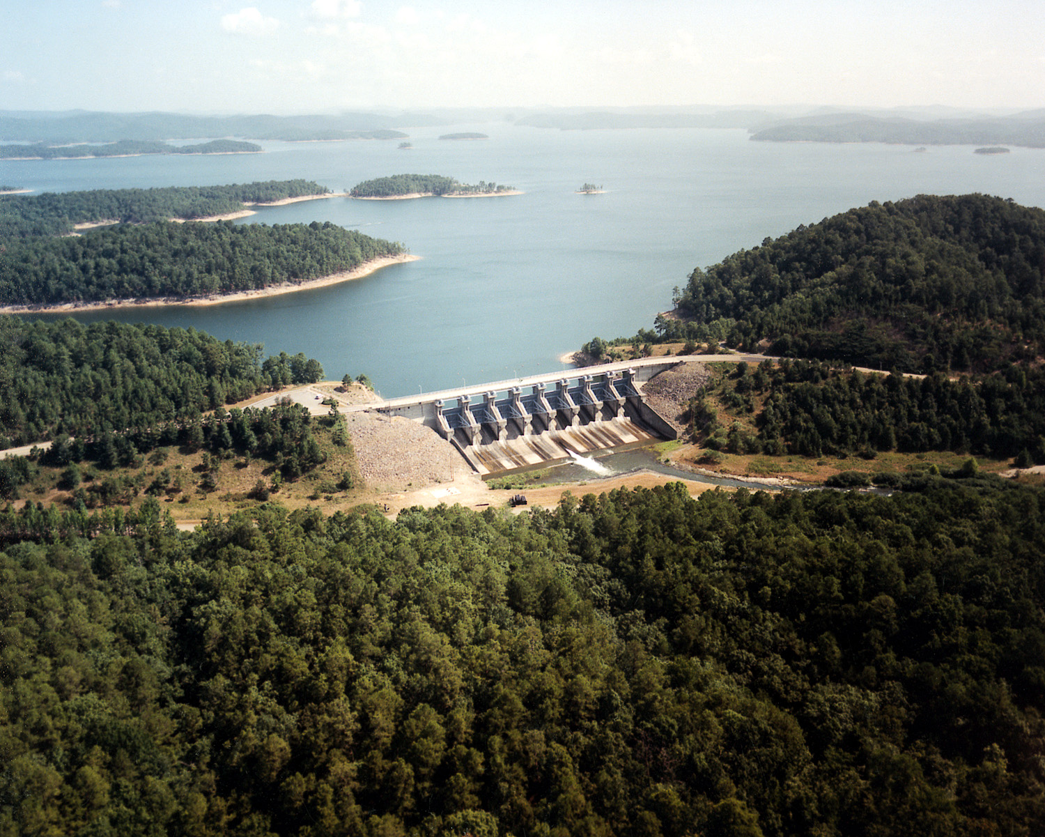
It is the third-largest county in Oklahoma by area.[3] The terrain of McCurtain County varies from the foothills of the Ouachita Mountains in the northern part of the county, to the rich Red River bottoms of the southern part. Sections of the Mountain Fork and Little River drainages lie in McCurtain County. The Glover River originates in McCurtain County and flows 33.2 miles (53.4 km) to its confluence with the Little River southeast of Wright City. Broken Bow Lake was created in 1968 by damming the Mountain Fork River; the River is one of the two year-round trout fisheries in the state. The lowest point in the state of Oklahoma is located on the Little River in McCurtain County, where it flows out of Oklahoma and into Arkansas.[3] McCurtain County is the only documented part of Oklahoma, together with Choctaw County, located within the natural range of the American alligator.[9]
The county also contains the McCurtain County Wilderness Area, a 14,087-acre tract created in 1918 and managed by the Oklahoma Department of Wildlife Conservation, and the Little River National Wildlife Refuge, which is managed by the U.S. Fish and Wildlife Service.[10]
The county contains the location (Smithville) with the highest annual average precipitation in the state, at 55.71 inches.[11]
Major highways
 U.S. Highway 70
 U.S. Highway 259
 State Highway 3
 State Highway 4
 State Highway 37
 State Highway 87
 State Highway 98
Adjacent counties
- Le Flore County (north)
- Polk County, Arkansas (northeast)
- Sevier County, Arkansas (east)
- Little River County, Arkansas (southeast)
- Bowie County, Texas (south)
- Red River County, Texas (southwest)
- Choctaw County (west)
- Pushmataha County (northwest)
National protected areas
- Little River National Wildlife Refuge
- Ouachita National Forest (part)
Demographics
| Historical population | |||
|---|---|---|---|
| Census | Pop. | %± | |
| 1910 | 20,681 | — | |
| 1920 | 37,905 | 83.3% | |
| 1930 | 34,759 | −8.3% | |
| 1940 | 41,318 | 18.9% | |
| 1950 | 31,588 | −23.5% | |
| 1960 | 25,851 | −18.2% | |
| 1970 | 28,642 | 10.8% | |
| 1980 | 36,151 | 26.2% | |
| 1990 | 33,433 | −7.5% | |
| 2000 | 34,402 | 2.9% | |
| 2010 | 33,151 | −3.6% | |
| 2019 (est.) | 32,832 | [12] | −1.0% |
| U.S. Decennial Census[13] 1790-1960[14] 1900-1990[15] 1990-2000[16] 2010-2019[1] | |||
At the 2000 census there were 34,402 people, 13,216 households, and 9,541 families in the county. The population density was 7/km2 (19/mi2). There were 15,427 housing units at an average density of 3/km2 (8/mi2). The racial makup of the county was 70.54% White, 9.30% Black or African American, 13.57% Native American, 0.22% Asian, 0.01% Pacific Islander, 1.34% from other races, and 5.02% from two or more races. 3.09%.[17] were Hispanic or Latino of any race. 28.6% were of American, 7.6% Irish and 5.9% English ancestry. 94.4% spoke English, 2.9% Spanish and 2.6% Choctaw as their first language.
Of the 13,216 households 34.00% had children under the age of 18 living with them, 53.30% were married couples living together, 14.60% had a female householder with no husband present, and 27.80% were non-families. 25.40% of households were one person and 11.00% were one person aged 65 or older. The average household size was 2.56 and the average family size was 3.06.
The age distribution was 28.20% under the age of 18, 8.30% from 18 to 24, 26.20% from 25 to 44, 23.40% from 45 to 64, and 14.00% 65 or older. The median age was 36 years. For every 100 females there were 92.80 males. For every 100 females age 18 and over, there were 89.10 males.
The median household income was $24,162 and the median family income was $29,933. Males had a median income of $26,528 versus $17,869 for females. The per capita income for the county was $13,693. About 21.00% of families and 24.70% of the population were below the poverty line, including 32.40% of those under age 18 and 21.20% of those age 65 or over.
Politics
| Voter Registration and Party Enrollment as of January 15, 2021[18] | |||||
|---|---|---|---|---|---|
| Party | Number of Voters | Percentage | |||
| Republican | 7,624 | 45.72% | |||
| Democratic | 7,419 | 44.50% | |||
| Independent | 1,574 | 9.44% | |||
| Libertarian | 57 | 0.34% | |||
| Total | 16,674 | 100% | |||
| Year | Republican | Democratic | Third party | |||
|---|---|---|---|---|---|---|
| No. | % | No. | % | No. | % | |
| 2020 | 9,485 | 82.72% | 1,858 | 16.20% | 124 | 1.08% |
| 2016 | 8,656 | 80.70% | 1,802 | 16.80% | 268 | 2.50% |
| 2012 | 7,635 | 75.78% | 2,440 | 24.22% | 0 | 0.00% |
| 2008 | 7,745 | 73.49% | 2,794 | 26.51% | 0 | 0.00% |
| 2004 | 7,472 | 66.98% | 3,684 | 33.02% | 0 | 0.00% |
| 2000 | 6,601 | 62.97% | 3,752 | 35.79% | 129 | 1.23% |
| 1996 | 3,892 | 39.82% | 4,350 | 44.51% | 1,532 | 15.67% |
| 1992 | 3,519 | 30.62% | 5,082 | 44.21% | 2,893 | 25.17% |
| 1988 | 4,920 | 49.64% | 4,928 | 49.72% | 63 | 0.64% |
| 1984 | 6,381 | 61.26% | 3,994 | 38.34% | 41 | 0.39% |
| 1980 | 5,189 | 45.63% | 5,953 | 52.35% | 230 | 2.02% |
| 1976 | 3,423 | 30.89% | 7,560 | 68.23% | 97 | 0.88% |
| 1972 | 6,441 | 70.20% | 2,568 | 27.99% | 166 | 1.81% |
| 1968 | 2,795 | 32.43% | 2,944 | 34.16% | 2,880 | 33.41% |
| 1964 | 2,981 | 33.26% | 5,982 | 66.74% | 0 | 0.00% |
| 1960 | 3,562 | 45.88% | 4,202 | 54.12% | 0 | 0.00% |
| 1956 | 2,707 | 36.25% | 4,761 | 63.75% | 0 | 0.00% |
| 1952 | 2,748 | 32.17% | 5,793 | 67.83% | 0 | 0.00% |
| 1948 | 1,091 | 14.92% | 6,223 | 85.08% | 0 | 0.00% |
| 1944 | 1,419 | 21.02% | 5,322 | 78.83% | 10 | 0.15% |
| 1940 | 2,225 | 24.06% | 6,994 | 75.63% | 29 | 0.31% |
| 1936 | 1,119 | 17.99% | 5,089 | 81.80% | 13 | 0.21% |
| 1932 | 587 | 9.07% | 5,886 | 90.93% | 0 | 0.00% |
| 1928 | 1,915 | 39.79% | 2,877 | 59.78% | 21 | 0.44% |
| 1924 | 1,669 | 32.19% | 3,279 | 63.24% | 237 | 4.57% |
| 1920 | 1,966 | 40.23% | 2,603 | 53.26% | 318 | 6.51% |
| 1916 | 795 | 24.75% | 1,763 | 54.89% | 654 | 20.36% |
| 1912 | 704 | 27.07% | 1,059 | 40.72% | 838 | 32.22% |
Economy
Agriculture and forestry have dominated the county's economy. The dense forests that originally covered the area were cleared and processed within two decades after statehood. The cleared lands then became subsistence farms. Cotton was the main money crop, until the cotton market collapsed during the Great Depression. Cattle raising, as well as production of swine and poultry, replaced cotton farming in importance. Cotton farms in the Red River valley began raising grains and forage instead.[3]
Natural reseeding and active reforestation projects, both public and private, have replenished much of the harvested forest area. This revitalized the timber industry, which is again important to the county economy.[3]
Limestone, sand and gravel are extracted for extensive local use.[3]
Communities
Cities
- Broken Bow
- Idabel (county seat)
Towns
Census-designated place
Other unincorporated communities
Notable people
- Harry Rossoll, creator of Smokey Bear and artist for the Forest Heritage Center diorama exhibits
See also
- National Register of Historic Places listings in McCurtain County, Oklahoma
References
- "State & County QuickFacts". United States Census Bureau. Archived from the original on June 6, 2011. Retrieved November 9, 2013.
- "Find a County". National Association of Counties. Archived from the original on May 31, 2011. Retrieved June 7, 2011.
- Coleman, Louis. "McCurtain County", Encyclopedia of Oklahoma History and Culture, Oklahoma Historical Society, 2009. Accessed April 4, 2015.
- "Origin of County Names in Oklahoma". In: Chronicles of Oklahoma. Volume 2, Number 1. March, 1924. Archived August 14, 2017, at the Wayback Machine Retrieved February 14, 2014.
- Morris, John W. Historical Atlas of Oklahoma (Norman: University of Oklahoma, 1986), plate 38.
- "National Weather Service".
- "Counties & Regions". Oklahoma Tourism and Recreation Department (Travel Promotion Division). Retrieved February 5, 2019.
- "2010 Census Gazetteer Files". United States Census Bureau. August 22, 2012. Retrieved February 21, 2015.
- "A Look at Oklahoma: A Student's Guide" (PDF). State of Oklahoma. 2005. Archived from the original (PDF) on December 30, 2006. Retrieved August 14, 2007.
- "McCurtain County Wilderness Area." McCurtain County Tourism Authority. 2008. Retrieved October 8, 2013.
- "Oklahoma Annual Rainfall and Climate Data". CoolWeather.net. Retrieved April 8, 2021.
- "County Population Totals: 2010-2019". Retrieved February 8, 2021.
- "U.S. Decennial Census". United States Census Bureau. Retrieved February 21, 2015.
- "Historical Census Browser". University of Virginia Library. Retrieved February 21, 2015.
- Forstall, Richard L., ed. (March 27, 1995). "Population of Counties by Decennial Census: 1900 to 1990". United States Census Bureau. Retrieved February 21, 2015.
- "Census 2000 PHC-T-4. Ranking Tables for Counties: 1990 and 2000" (PDF). United States Census Bureau. April 2, 2001. Archived (PDF) from the original on October 9, 2022. Retrieved February 21, 2015.
- "U.S. Census website". United States Census Bureau. Retrieved January 31, 2008.
- "Oklahoma Registration Statistics by County" (PDF). OK.gov. January 15, 2021. Archived (PDF) from the original on October 9, 2022. Retrieved October 10, 2021.
- Leip, David. "Dave Leip's Atlas of U.S. Presidential Elections". uselectionatlas.org. Retrieved March 29, 2018.
External links
- McCurtain County Tourism Authority
- McCurtain County OSU Extension Center
- Beavers Bend Cabins near Broken Bow Lake and Beavers Bend State Park
- Oklahoma Digital Maps: Digital Collections of Oklahoma and Indian Territory
Places adjacent to McCurtain County, Oklahoma | ||||||||||||||||
|---|---|---|---|---|---|---|---|---|---|---|---|---|---|---|---|---|
| ||||||||||||||||
Municipalities and communities of McCurtain County, Oklahoma, United States | ||
|---|---|---|
County seat: Idabel | ||
| Cities |  | |
| Towns | ||
| CDPs | ||
| Other communities | ||
| Ghost towns |
| |
| Indian reservation |
| |
| Footnotes | ‡This populated place also has portions in another county or counties | |
| ||
Authority control | |
|---|---|
| General | |
| National libraries | |
На других языках
[de] McCurtain County
McCurtain County[1] ist ein County im Bundesstaat Oklahoma der Vereinigten Staaten. Der Verwaltungssitz (County Seat) ist Idabel.- [en] McCurtain County, Oklahoma
[ru] Мак-Кертен (округ)
Округ Мак-Кертен (англ. McCurtain County) располагается в штате Оклахома, США. Официально образован в 1907 году. По состоянию на 2013 год, численность населения составляла 33 065 человек.Другой контент может иметь иную лицензию. Перед использованием материалов сайта WikiSort.org внимательно изучите правила лицензирования конкретных элементов наполнения сайта.
WikiSort.org - проект по пересортировке и дополнению контента Википедии