world.wikisort.org - USA
Nashua is a city in southern New Hampshire, United States. As of the 2020 census, it had a population of 91,322,[3] the second-largest in northern New England after nearby Manchester. Along with Manchester, it is a seat of New Hampshire's most populous county, Hillsborough.
Nashua, New Hampshire | |
|---|---|
City | |
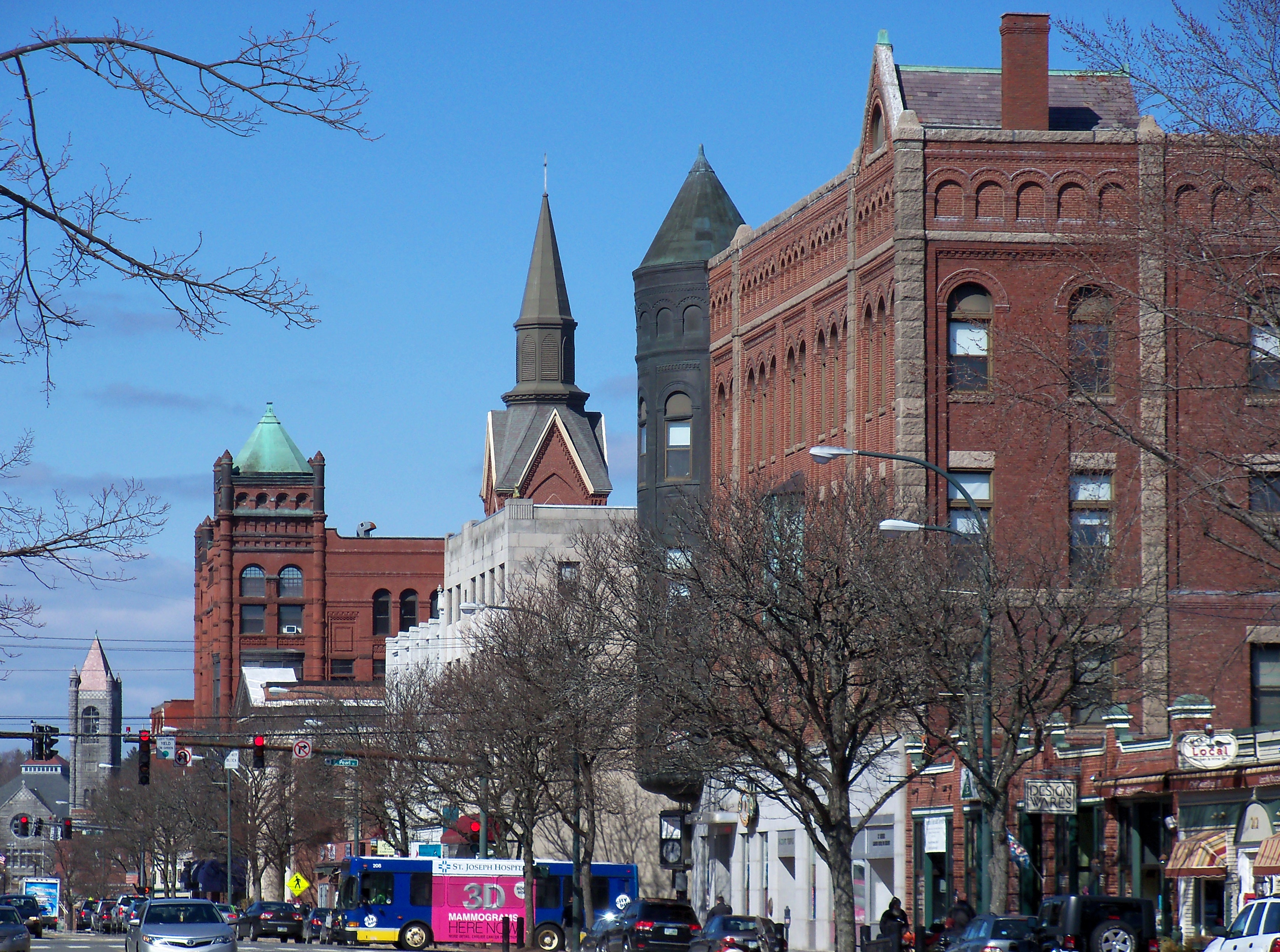 Main Street in downtown Nashua | |
 Seal | |
| Nickname: Gate City (unofficial) | |
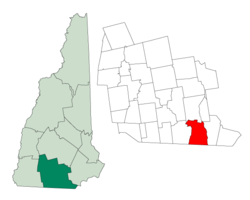 Location in Hillsborough County, New Hampshire | |
 Nashua Location in New Hampshire  Nashua Location in the United States | |
| Coordinates: 42°45′27″N 71°27′52″W | |
| Country | |
| State | |
| County | Hillsborough |
| Settled | 1655 |
| Town | 1746 |
| City | 1853 |
| Government | |
| • Mayor | Jim Donchess |
| • Board of Aldermen[1] | Members
|
| Area | |
| • Total | 31.73 sq mi (82.19 km2) |
| • Land | 30.83 sq mi (79.86 km2) |
| • Water | 0.90 sq mi (2.33 km2) 2.84% |
| Elevation | 151 ft (46 m) |
| Population (2020) | |
| • Total | 91,322 |
| • Density | 2,961.73/sq mi (1,143.52/km2) |
| Time zone | UTC−5 (Eastern) |
| • Summer (DST) | UTC−4 (Eastern) |
| ZIP codes |
|
| Area code | 603 |
| FIPS code | 33-50260 |
| GNIS feature ID | 0868677 |
| Website | www |
Built around the now-departed textile industry, in recent decades Nashua's economy has shifted to the financial services, high tech, and defense industries as part of the economic recovery that started in the 1980s in the Greater Boston region. Major private employers in the city include Nashua Corporation, BAE Systems, and Teradyne.[4] The city also hosts two major regional medical centers, Southern New Hampshire Medical Center and St. Joseph Hospital. The South Nashua commercial district is a major regional shopping destination, lying directly on the Massachusetts border and taking advantage of New Hampshire's lack of sales tax. It is anchored by the Pheasant Lane Mall and numerous smaller shopping centers.
Nashua was three times named one of the "Best Places to Live in America" in annual surveys by Money magazine, most recently in 2022.[5] It is one of many cities nicknamed "Gate City" because they are seen as the entry point, or gateway, to a region.
History
The area was part of a 200-square-mile (520 km2) tract of land in Massachusetts called "Dunstable", named after Edward Tyng of Dunstable in England.[6][7] Located at the confluence of the Nashua and Merrimack rivers, Dunstable was first settled about 1654 as a fur trading town. Nashua lies approximately in the center of the original 1673 grant.[6] In 1732, Dunstable was split along the Merrimack River, with the town of Nottingham (now the town of Hudson, New Hampshire) created out of the eastern portion. The previously disputed boundary between Massachusetts and New Hampshire was fixed in 1741 when the governorships of the two provinces were separated.[6] As a result, the township of Dunstable was divided in two. Tyngsborough and some of Dunstable remained in Massachusetts, while Dunstable, New Hampshire, was incorporated in 1746 from the northern section of the town.[6]
Like many 19th century riverfront New England communities, New Hampshire's Dunstable was developed during the Industrial Revolution with textile mills operated from water power.[7] In 1823, the Nashua Manufacturing Company was incorporated.[7] The company eventually had four mills and employed approximately 1,000 people.[7] The following year, the Jackson Manufacturing Company was incorporated.[8]
In 1836, the New Hampshire half of Dunstable was renamed "Nashua", after the Nashua River; the Dunstable name lives on across the Massachusetts border.[9][10] The Nashua River was named by the Nashaway people, and in the Penacook language it means "beautiful stream with a pebbly bottom",[11][12] with an alternative meaning of "land between two rivers".[13][14] In 1842, the town split into two towns.[9] Eleven years later, they joined back together under the name "Nashua", and were re-incorporated as a city.[9] During the split, the northern area, known today as "French Hill", called itself "Nashville", while the southern part kept the name Nashua.[10]
Six railroad lines crossed the mill town, namely the Nashua and Lowell, Worcester and Nashua, Nashua and Acton, Nashua and Wilton, Concord and Nashua, and Rochester railroads.[15]
Like the rival Amoskeag Manufacturing Company upriver in Manchester,[16] the Nashua mills prospered until about World War I, after which a slow decline set in. Water power was replaced with newer forms of energy to run factories, such as coal, and cotton could be manufactured into fabric where it grew, saving transportation costs.[17] The textile business started moving to the South during the Great Depression,[18] with the last mill near Nashua closing in 1949.[19]
But then Sanders Associates, a newly created defense firm that is now part of BAE Systems, moved into one of the closed mills and helped restart the city's economy.[20][21] Sanders Associates also played a key role in the development of the home video game console market. Ralph H. Baer, an employee of Sanders, developed what would become the Magnavox Odyssey, the first commercial home video game system.[22] The arrival of Digital Equipment Corp., now part of Hewlett-Packard,[23] in the 1970s made the city part of the Boston-area high-tech corridor.[24][25]
 An 1883 bird's-eye engraving of Nashua
 The Nashua Millyard
 Canal St. Bridge, c. 1908
 The Willows, c. 1910; the road is now Route 101A near Somerset Plaza
 Hunt Memorial Library in 2006


Geography

Nashua is in southeastern Hillsborough County. It is bordered to the south by Middlesex County, Massachusetts.
According to the United States Census Bureau, the city has a total area of 31.7 square miles (82.2 km2), of which 30.8 square miles (79.9 km2) are land and 0.89 square miles (2.3 km2) are water, comprising 2.84% of the city.[26] The eastern boundary of Nashua is formed by the Merrimack River, and the city is drained by the Nashua River and Salmon Brook, tributaries of the Merrimack. The Nashua River roughly bisects the city. Pennichuck Brook forms the city's northern boundary. The highest point in Nashua is Gilboa Hill in the southern part of the city, at 426 feet (130 m) above sea level.[27]
Climate
Nashua has a four-season humid continental climate (Köppen Dfb), with short spring and autumn transitions, long humid and warm summers, and cold winters full of snow. Spring and autumn in between are relatively brief transitions. The monthly daily average temperature ranges from 22.7 °F (−5.2 °C) in January to 70.9 °F (21.6 °C) in July. On average, there are 9.4 days of 90 °F (32 °C)+ highs and 8.7 days of sub-0 °F (−18 °C) lows. Precipitation is well-spread throughout the year, though winter is the driest. Snowfall, the heaviest of which typically comes from nor'easters, averages around 55 inches (140 cm) per season, but can vary widely from year to year.
| Climate data for Nashua, New Hampshire (1991–2020 normals, extremes 1885–present) | |||||||||||||
|---|---|---|---|---|---|---|---|---|---|---|---|---|---|
| Month | Jan | Feb | Mar | Apr | May | Jun | Jul | Aug | Sep | Oct | Nov | Dec | Year |
| Record high °F (°C) | 69 (21) |
76 (24) |
85 (29) |
93 (34) |
100 (38) |
100 (38) |
106 (41) |
105 (41) |
99 (37) |
91 (33) |
81 (27) |
73 (23) |
106 (41) |
| Average high °F (°C) | 34.4 (1.3) |
37.4 (3.0) |
45.1 (7.3) |
58.5 (14.7) |
70.0 (21.1) |
78.4 (25.8) |
84.0 (28.9) |
82.6 (28.1) |
75.3 (24.1) |
62.8 (17.1) |
51.0 (10.6) |
40.0 (4.4) |
60.0 (15.6) |
| Daily mean °F (°C) | 24.1 (−4.4) |
26.1 (−3.3) |
34.3 (1.3) |
46.4 (8.0) |
58.0 (14.4) |
67.1 (19.5) |
72.7 (22.6) |
70.9 (21.6) |
63.3 (17.4) |
50.8 (10.4) |
40.2 (4.6) |
30.4 (−0.9) |
48.7 (9.3) |
| Average low °F (°C) | 13.7 (−10.2) |
14.9 (−9.5) |
23.4 (−4.8) |
34.4 (1.3) |
46.0 (7.8) |
55.8 (13.2) |
61.4 (16.3) |
59.3 (15.2) |
51.2 (10.7) |
38.8 (3.8) |
29.5 (−1.4) |
20.8 (−6.2) |
37.4 (3.0) |
| Record low °F (°C) | −29 (−34) |
−35 (−37) |
−18 (−28) |
8 (−13) |
20 (−7) |
31 (−1) |
37 (3) |
31 (−1) |
23 (−5) |
12 (−11) |
−7 (−22) |
−24 (−31) |
−35 (−37) |
| Average precipitation inches (mm) | 3.44 (87) |
3.22 (82) |
4.31 (109) |
4.21 (107) |
3.90 (99) |
4.32 (110) |
3.65 (93) |
3.91 (99) |
4.05 (103) |
4.84 (123) |
3.88 (99) |
4.46 (113) |
48.19 (1,224) |
| Average snowfall inches (cm) | 14.7 (37) |
14.5 (37) |
10.1 (26) |
0.7 (1.8) |
0.0 (0.0) |
0.0 (0.0) |
0.0 (0.0) |
0.0 (0.0) |
0.0 (0.0) |
0.0 (0.0) |
1.7 (4.3) |
11.2 (28) |
52.9 (134) |
| Average precipitation days (≥ 0.01 in) | 9.2 | 8.4 | 9.2 | 10.8 | 12.1 | 10.9 | 10.4 | 9.3 | 9.2 | 10.8 | 10.0 | 10.1 | 120.4 |
| Average snowy days (≥ 0.1 in) | 5.4 | 4.8 | 3.4 | 0.5 | 0.0 | 0.0 | 0.0 | 0.0 | 0.0 | 0.1 | 0.8 | 3.9 | 18.9 |
| Source: NOAA[28][29] | |||||||||||||
Demographics
| Historical population | |||
|---|---|---|---|
| Census | Pop. | %± | |
| 1790 | 632 | — | |
| 1800 | 862 | 36.4% | |
| 1810 | 1,049 | 21.7% | |
| 1820 | 1,142 | 8.9% | |
| 1830 | 2,417 | 111.6% | |
| 1840 | 6,054 | 150.5% | |
| 1850 | 5,820 | −3.9% | |
| 1860 | 10,065 | 72.9% | |
| 1870 | 10,543 | 4.7% | |
| 1880 | 13,397 | 27.1% | |
| 1890 | 19,311 | 44.1% | |
| 1900 | 23,898 | 23.8% | |
| 1910 | 26,005 | 8.8% | |
| 1920 | 28,379 | 9.1% | |
| 1930 | 31,463 | 10.9% | |
| 1940 | 32,927 | 4.7% | |
| 1950 | 34,669 | 5.3% | |
| 1960 | 39,096 | 12.8% | |
| 1970 | 55,820 | 42.8% | |
| 1980 | 67,865 | 21.6% | |
| 1990 | 79,662 | 17.4% | |
| 2000 | 86,605 | 8.7% | |
| 2010 | 86,494 | −0.1% | |
| 2020 | 91,322 | 5.6% | |
| U.S. Decennial Census[3][30] | |||
| Race | Percentage |
|---|---|
| White, not Hispanic or Latino | 73% |
| Hispanic or Latino | 13% |
| Asian | 8% |
| Black or African American | 4% |
As of the census of 2010,[32] there were 86,494 people, 35,044 households, and 21,876 families residing in the city. The population density was 2,719.9 people per square mile (1,050.2/km2). There were 37,168 housing units at an average density of 1,202.8 per square mile (464.6/km2). The racial makeup of the city was 83.4% White, 2.7% African American, 0.3% Native American, 6.5% Asian, 0.03% Pacific Islander, 4.6% from some other race, and 2.5% from two or more races. Hispanic or Latino of any race were 9.8% of the population.
There were 35,044 households, out of which 28.7% had children under the age of 18 living with them, 45.9% were married couples living together, 11.6% had a female householder with no husband present, and 37.6% were non-families. 29.4% of all households were made up of individuals, and 9.6% had someone living alone who was 65 years of age or older. The average household size was 2.42 and the average family size was 3.01.
In the city the population was spread out, with 22.1% under the age of 18, 9.3% from 18 to 24, 28.0% from 25 to 44, 27.8% from 45 to 64, and 12.7% who were 65 years of age or older. The median age was 38.5 years. For every 100 females, there were 97.3 males. For every 100 females age 18 and over, there were 95.8 males.
In 2011 the estimated median income for a household in the city was $60,923, and the median income for a family was $76,612. Male full-time workers had a median income of $60,365 versus $43,212 for females. The per capita income for the city was $30,937. About 4.6% of families and 9.3% of the population were below the poverty line, including 11.4% of those under age 18 and 5.9% of those age 65 or over.[33]
Economy

Nashua has three main commercial districts. Centered on Main Street near the geographic center of the city, Downtown Nashua is the oldest of the commercial districts, featuring commercial, entertainment, and dining venues, near historic commercial buildings and homes as well. Recent plans have incorporated the Nashua River into the design of a pedestrian-friendly walkway. The downtown Nashua Riverwalk is a large, public/private venture funded through the use of tax increment financing (TIF). Amherst Street (Route 101A) is in the northwestern part of the city and is a large thoroughfare with commercial centers along both sides. The South Nashua Commercial District, centered on Daniel Webster Highway near the Massachusetts border, is anchored by the Pheasant Lane Mall, attracting many people from Massachusetts taking advantage of the lack of sales tax in New Hampshire.
The city is home to a number of technical firms, including Nashua Corporation, which took its name from the city and river. Nashua Corp. was a leading producer of floppy disks through the early 1990s, making the Nashua name well known in the world of personal computers.
Defense contractor BAE Systems (formerly Sanders Associates), computer firm Dell,[34] and software company Oracle Corporation are the largest representatives of the high-tech industry prominent in the region. The Boston Air Route Traffic Control Center is in Nashua. The three-building campus that once housed a Digital Equipment Corporation software development facility was sold to the John Flatley Company, which has renamed it "Nashua Technology Park".[35]
Sports
Nashua has had a series of amateur, semi-professional, and professional baseball teams. The Nashua Silver Knights, part of the Futures Collegiate Baseball League of New England (FCBL), is the city's current team. The Nashua Pride, a Can-Am minor league baseball team, played at Holman Stadium from 1998 through 2008, then changed to the American Defenders of New Hampshire in the 2009 season. The Defenders were evicted from the venue in August 2009, however, because of non-payment of rent, and moved to Pittsfield, Massachusetts to become the Pittsfield Colonials. Before the Pride, Holman was the home stadium for the independent Nashua Hawks; the AA Nashua Pirates; the AA Nashua Angels; and the A Nashua Dodgers, the first racially integrated professional baseball team in the 20th century.[36]
In collegiate sports, Nashua is home to the Rivier University Raiders, who compete in the Great Northeast Athletic Conference (GNAC).
The Spartans Drum and Bugle Corps (1997, 1998, 2004, 2007 Drum Corps International Division II Champions and 2019 Open Class Champions) is based in Nashua.
Government

The city's government is headed by a mayor and fifteen aldermen: six at-large aldermen elected three at a time every four years, and nine ward aldermen, one for each ward in the city, elected every two years.
In the New Hampshire General Court, Nashua is represented in the House by Hillsborough County's 20th (Ward 1), 21st (Ward 2), 22nd (Ward 3), 23rd (Ward 4), 24th (Ward 6), 25th (Ward 7) and 26th (Wards 5, 8 and 9) districts and in the Senate by District 12 (Wards 1, 2, and 5, shared with Hollis, Mason, Brookline, Greenville, New Ipswich, and Rindge) and District 13 (Wards 3, 4, 6, 7, 8, and 9).
In the New Hampshire Senate, Nashua is represented by two state senators:
- Republican Kevin Avard (District 12) – Wards 1–2, 5
- Democrat Cindy Rosenwald (District 13) – Wards 3–4, 6-9
In the New Hampshire Executive Council, Nashua is included within the 5th District and is currently represented by Republican Dave Wheeler. Nashua is included within New Hampshire's 2nd congressional district and is currently represented by Democrat Ann McLane Kuster in the U.S. House of Representatives.
At the presidential level, Nashua leans strongly towards Democrats. George H. W. Bush was the last Republican presidential nominee to win Nashua in 1988.
| Year | Democratic | Republican | Third Parties |
|---|---|---|---|
| 2020 | 59.11% 26,770 | 39.31% 17,806 | 1.58% 705 |
| 2016 | 52.74% 22,690 | 40.62% 17,476 | 6.64% 2,859 |
| 2012 | 56.07% 23,413 | 42.28% 17,658 | 1.65% 689 |
| 2008 | 56.09% 22,902 | 42.43% 17,325 | 1.48% 605 |
| 2004 | 54.02% 21,587 | 45.09% 18,016 | 0.89% 355 |
| 2000 | 53.24% 18,398 | 42.84% 14,803 | 3.92% 1,353 |
| 1996 | 52.72% 16,632 | 36.53% 11,525 | 10.75% 3,393 |
| 1992 | 40.75% 14,777 | 34.51% 12,514 | 24.74% 8,970 |
| 1988 | 39.21% 12,833 | 59.18% 19,369 | 1.60% 525 |
| 1984 | 35.17% 9,305 | 64.11% 16,961 | 0.73% 192 |
| 1980 | 34.35% 9,156 | 52.04% 13,874 | 13.61% 3,628 |
| 1976 | 52.92% 13,014 | 45.15% 11,103 | 1.94% 477 |
| 1972 | 45.82% 10,434 | 52.85% 12,034 | 1.33% 302 |
| 1968 | 61.39% 12,928 | 35.26% 7,425 | 3.35% 705 |
| 1964 | 76.98% 15,663 | 23.02% 4,685 | 0.00% 0 |
| 1960 | 68.81% 13,883 | 31.19% 6,293 | 0.00% 0 |
| Year | Office | Results |
|---|---|---|
| 2010 | Senator | Ayotte 59–38% |
| House | Bass 49–46% | |
| Governor | Lynch 56–42% | |
| 2012 | President | Obama 56–42% |
| House | Kuster 53–43% | |
| Governor | Hassan 59–38% | |
| 2014 | Senator | Shaheen 53–47% |
| House | Kuster 57–43% | |
| Governor | Hassan 53–47% | |
| 2016 | President | Clinton 54–41% |
| Senator | Hassan 52–44% | |
| House | Kuster 53–42% | |
| Governor | Van Ostern 51–44% | |
| 2018 | House | Kuster 59–39% |
| Governor | Kelly 51–47% | |
| 2020 | President | Biden 60–39% |
| Senator | Shaheen 63–35% | |
| House | Kuster 58–39% | |
| Governor | Sununu 60–39% |
Education

In the 2000 U.S Census, 22,700 residents over age three were enrolled in a Nashua educational institution, approximately a fourth of the city.[38]
Secondary schools
Public
- Nashua High School South (formerly Nashua High School, 1976–2004)
- Nashua High School North
- Brentwood Academy
Private
- Bishop Guertin High School, a coeducational Catholic high school
Public charter school
- Academy for Science and Design
Middle schools
Public
- Elm Street Middle School
- Fairgrounds Middle School
- Pennichuck Middle School
Private
- Saint Christopher Academy (Upper Campus)
- World Academy
Elementary schools
Public
- Amherst Street Elementary School
- Bicentennial Elementary School
- Birch Hill Elementary School
- Broad Street Elementary School
- Charlotte Avenue Elementary School
- Dr. Norman W. Crisp Elementary School
- Fairgrounds Elementary School
- Ledge Street Elementary School
- Main Dunstable Elementary School
- Mount Pleasant Elementary School
- New Searles Elementary School
- Sunset Heights Elementary School
Colleges
- Nashua Community College (NCC)
- Granite State College, which shares a campus with NCC.[39]
- Rivier University
- Southern New Hampshire University's Nashua campus
former colleges
- Daniel Webster College (DWC): closed in May 2017.[40]
Media
The local newspaper is The Telegraph, with daily news published online and a weekly printed edition.
Nashua radio stations include oldies station WGHM 900 AM (ESPN affiliate), talk station WSMN 1590 AM, and 106.3 WFNQ, a classic hits station owned by Binnie Media. WEVS 88.3 and 90.3 serve as the stations for New Hampshire Public Radio. The city is part of the Manchester radio market and can also receive almost all Boston-market stations clearly.
One television station is licensed to Nashua. WBTS-CD (channel 15) is owned by NBC Owned Television Stations, and serves as the NBC owned-and-operated station for the Boston market. The station moved from its own transmitter to a channel share with PBS member station WGBX-TV from their Needham, Massachusetts tower in 2018 upon NBC's assumption of ownership, letting it broadcast the "NBC Boston" service (previously carried by a low-power station in Boston and subchannels of other stations) across the entire market. As WYCN-CD, it formerly carried a number of smaller networks, along with local programming and community calendar information of interest to Nashuans, until the sale to NBC.
Infrastructure
Transportation
Roads
The Everett Turnpike is the major highway running through the city. U.S. Route 3 follows the turnpike from the Massachusetts border north to Exit 7E, where it branches to the northeast along the two-lane Henri A. Burque Highway to Concord Street and then heads north into the town of Merrimack. Other New Hampshire state highways in the city include:
- NH 101A, which enters the city from the northwest and follows Amherst Street to its terminus at Main Street.
- NH 111, which enters the city from the southwest and follows Hollis Street to the city's eastern border at the Merrimack River, crossing into Hudson on the twin-span Taylor Falls/Veterans Memorial bridges.
- NH 111A, which enters the city from the southwest and follows Groton Road to Main Dunstable Road to its terminus at Hollis Street.
- NH 130, which enters the city from the west and follows Broad Street to its terminus at Amherst Street.
Maps of the Nashua area often show a stretch of freeway forming a circumferential highway through Nashua and the neighboring town of Hudson. Only a small section of the south end of this highway (Exit 2 off U.S. Route 3) has been built, and it is unclear whether the highway will ever be completed. If finished, the Nashua-Hudson Circumferential Highway would be part of the Everett Turnpike, and would rejoin the mainline highway at a hypothetical Exit 9 in northern Nashua.
In 2015, after four years of construction, the city completed the Broad Street Parkway,[41] which connects Exit 6 of the Everett Turnpike to the city's downtown area ("Tree Streets" neighborhood), with the goal of easing traffic congestion and opening up Nashua's old mill-yard as part of the city's economic development.[42] The new parkway provides a third crossing of the Nashua River and a way for traffic to avoid Library Hill, a busy downtown intersection. The idea of a road connecting Broad Street with Hollis Street within the city had been discussed since the 1960s.[43]
Public transportation is provided by the Nashua Transit System, which has nine scheduled bus routes in the city. Boston Express, a subsidiary of Concord Coach Lines, operates a Nashua-Boston bus line that runs out of the Nashua Transit Center off Exit 8 on the Everett Turnpike. This line transports passengers to South Station and Logan International Airport in Boston.[44]
Airports

Nashua Airport (Boire Field), a general aviation facility, is in the city's northwest corner. The nearest airports with scheduled airline service are Manchester–Boston Regional Airport in Manchester and Logan International Airport in Boston.
Past trolleys
Historically, Nashua was a hub for the trolley system in New Hampshire. Trolleys could be taken south to Boston, as well as north into Manchester and to locations as far east as Hampton, New Hampshire. The trolley also connected different areas of the city, with the Nashua line ending at the city dance hall. The trolley system decreased in popularity in the 20th century, finally closing in 1932.[45]
Future railroads
Efforts are being made to extend the MBTA Commuter Rail's Lowell Line from Lowell to Manchester, stopping at Nashua along the way. The state legislature created the New Hampshire Rail Transit Authority (NHRTA) in 2007 with the goal of overseeing the development of commuter rail in the state. The Nashua Board of Aldermen signed a memorandum of understanding, on October 11, 2017, with the Boston Surface Railroad Company in the creation of a commuter rail line in the near future. The proposed line would connect Lowell, Massachusetts, to Bedford, New Hampshire, with the end station being near the Manchester–Boston Regional Airport.[46][47] As of November, 2022, an ongoing study by AECOM and the State of New Hampshire for design and financing is due to be completed by early 2023, and the project is awaiting federal funding.[48] Nashua is proposed to have two station stops on the line, South Nashua, which would be located behind the Pheasant Lane Mall just north of the state line, and Nashua, which would be located in a rail yard near Crown Street in downtown Nashua and would utilize the existing Crown Street park-and-ride lot.[49]
Firefighting
The fire department of Nashua, Nashua Fire, has 176 full-time members and is responsible for 31.9 square miles (83 km2), protecting a population of 87,259. In the city, there are six stations. There is one fire chief, one assistant chief, and four deputy chiefs. The department has six engines, three ladder trucks, one haz-mat/rescue truck (known as Special Hazards 1), two brush trucks, two spare engines, and one spare ladder truck.[50] Nashua uses a private ambulance service, American Medical Response. The department has five fire commissioners. The commission has overall responsibility for the policy decisions, promotions, discipline, hiring and terminations. The fire chief reports directly to the commission. Their responsibility is to also work with fire administration with planning and prioritizing the department budget.[51]
Health care
There are two hospitals in Nashua, St. Joseph Hospital and Southern New Hampshire Health System.
Notable people
In popular culture
An episode of MTV's MADE was filmed in 2004 at Nashua High School North.[52]
Russian dressing was created in Nashua by James E. Colburn, likely in the 1910s.[53]
Sister cities
See also
- Mine Falls Park
- Nashua River Rail Trail
- Greeley Park
References
- Board of Aldermen on Nashua city website
- "ArcGIS REST Services Directory". United States Census Bureau. Retrieved September 20, 2022.
- "Nashua city, Hillsborough County, New Hampshire: 2020 DEC Redistricting Data (PL 94-171)". U.S. Census Bureau. Retrieved December 3, 2021.
- "Employment and Industries in the Nashua, New Hampshire Area". City Town Info. Retrieved 20 July 2021.
- Meighan, Patrick (July 13, 2010). "Nashua cracks Money's top 100". Nashua Telegraph. Retrieved March 29, 2017.
- "Nashua Illustrated". Newspapers.com. August 26, 1875. Retrieved June 16, 2021.
{{cite web}}: CS1 maint: url-status (link) - Coolidge, Austin Jacobs; Mansfield, John Brainard (1859). A History and Description of New England, General and Local: Maine, New Hampshire, and Vermont. A.J. Coolidge. pp. 585–91.
- Hayward, John (1997). The New England Gazetteer. Heritage Books. ISBN 978-0-7884-0003-2.
- "Roadside History: Old Dunstable". UnionLeader.com. Retrieved June 16, 2021.
- "History of Nashua". City of Nashua. Retrieved March 29, 2017.
- "NIAC Publications ~ Nipmuc Place Names - Maine & Massachusetts". www.nativetech.org.
- The Native North American Almanac. Gale Research, Incorporated. 2001. ISBN 978-0-7876-1655-7.
- "A Short History of Nashua" on the city website Archived November 10, 2013, at the Wayback Machine
- Stylianos, Joan. "Heart of Nashua: How well do you know your city?". UnionLeader.com. Retrieved June 16, 2021.
- "The Railroad — Integral Part in Nashua's Growth". Newspapers.com. January 8, 1965. Retrieved June 16, 2021.
{{cite web}}: CS1 maint: url-status (link) - "Heart of Nashua: Whatever happened to Textile Field?". UnionLeader.com. Retrieved June 16, 2021.
- Koistinen, David (2002). "The Causes of Deindustrialization: The Migration of the Cotton Textile Industry from New England to the South". Enterprise & Society. 3 (3): 482–520. doi:10.1093/es/3.3.482. ISSN 1467-2227. JSTOR 23699718.
- Kennedy, John F. (January 1, 1954). "New England and the South". The Atlantic. Retrieved June 17, 2021.
- "Milford Textron Plant Closes Down". Newspapers.com. December 30, 1949. Retrieved June 17, 2021.
{{cite web}}: CS1 maint: url-status (link) - "Aug 23, 1952, Page 1 - Nashua Telegraph at Newspapers.com". Newspapers.com. Retrieved June 17, 2021.
- "Arrival of BAE – then known as Sanders – helped Nashua economy recover". nashuatelegraph.com. Retrieved June 17, 2021.
- Martin, Douglas (December 8, 2014). "Ralph H. Baer, Inventor of First System for Home Video Games, Is Dead at 92". The New York Times. ISSN 0362-4331. Retrieved June 17, 2021.
- "A look back at Digital Equipment Corp". Boston.com. Retrieved June 17, 2021.
- "Digital to build in Nashua". Newspapers.com. March 10, 1976. Retrieved June 17, 2021.
{{cite web}}: CS1 maint: url-status (link) - Leibovich, Mark (March 25, 1998). "A Tech Corridor's Life Cycle". The Washington Post.
{{cite news}}: CS1 maint: url-status (link) - "2021 U.S. Gazetteer Files – New Hampshire". United States Census Bureau. Retrieved December 3, 2021.
- "City of Nashua Conservation and Preservation, Section B ("Natural Nashua"), Section 1 ("Topography")". Archived from the original on November 5, 2014. Retrieved November 4, 2012.
- "NowData – NOAA Online Weather Data". National Oceanic and Atmospheric Administration. Retrieved May 18, 2021.
- "Station: Nashua 2 NNW, NH". U.S. Climate Normals 2020: U.S. Monthly Climate Normals (1991-2020). National Oceanic and Atmospheric Administration. Retrieved May 18, 2021.
- "U.S. Decennial Census". Census.gov. Retrieved November 4, 2014.
- "U.S Census Bureau QuickFacts".
{{cite web}}: CS1 maint: url-status (link) - "Profile of General Population and Housing Characteristics: 2010 Demographic Profile Data, Nashua city, New Hampshire". United States Census Bureau. Retrieved November 9, 2011.
- "Selected Economic Characteristics: 2011 American Community Survey 1-Year Estimates (DP03), Nashua city, New Hampshire". U.S. Census Bureau. Archived from the original on February 12, 2020. Retrieved February 22, 2013.
- "Product Services Enterprise Technical Support jobs in the United States of America at Dell". Archived from the original on 2013-01-21. Retrieved 2016-02-06.
- "Nashua Technology Park".
- Gray, Kevin (2005-10-06). "Don Newcombe diversity dinner speaker Jan. 16". New Hampshire Cultural Diversity Awareness Council. Archived from the original on 2007-10-17. Retrieved 2007-10-20.
As members of the Nashua Dodgers, Campanella and Newcombe were the first professional, African-American baseball players to compete on a racially integrated U.S. team in the 20th century.
- "Election Results". sos.nh.gov.
- Bureau, U.S. Census. "American FactFinder - Results". factfinder.census.gov. Archived from the original on 2020-02-12. Retrieved 2005-12-08.
- CURTIS, DANIELLE (27 July 2012). "Nashua Community College, Granite State College partner on bachelor's degree program". Nashua Telegraph. Retrieved 29 August 2015.
- Moore, Jim (October 25, 2017). "Nonprofit college aviation program grows". AOPA. Retrieved November 28, 2017.
- "Broad Street Parkway".Broad Street Parkway
- Rich-Kern, Sheryl (December 19, 2015). "Long-awaited Broad Street Parkway Opens in Nashua". New Hampshire Public Radio. Retrieved March 3, 2016.
- "Archived copy" (PDF). Archived from the original (PDF) on 2011-09-29. Retrieved 2011-05-02.
{{cite web}}: CS1 maint: archived copy as title (link) - "Nashuatelegraph.com: Smooth sailing for bus to Boston". 29 August 2007. Archived from the original on 29 August 2007. Retrieved 12 February 2018.
- "PSNH is now Eversource" (PDF). Archived from the original (PDF) on 2016-03-04. Retrieved 2014-11-25.
- Wheeler, Christine DeLong (2017-10-11). "Commuter rail proposal continues to move forward". WMUR. Retrieved 2017-10-14.
- Andrew Sylvia (2021-08-30). "Pappas on rail expansion: 'This is a project that continues to bubble from the bottom up here in New Hampshire' | Manchester Ink Link". manchesterinklink.com. Retrieved 2021-11-11.
- "Nashua - Manchester 40818 | Project Specific Information | Project Center | NH Department of Transportation". www.nh.gov. Retrieved 2022-11-16.
- chrome-extension://efaidnbmnnnibpcajpcglclefindmkaj/https://www.nh.gov/dot/projects/nashuamanchester40818/documents/40818-pre-06092021.pdf
- "Fire Rescue News - Nashua, NH". www.nashuanh.gov.
- "Nashua, NH". www.nashuanh.gov.
- "HippoPress -- The Hippo -- Guide to Manchester and Nashua NH". archives.hippopress.com.
- Krupa, Michelle (March 29, 2017). "Russian dressing is actually from Nashua, New Hampshire". CNN. Retrieved March 29, 2017.
- "Mysuru and Nashua sister cities to have bilateral relationship initiative - Mysuru Today". Mysuru Today. September 27, 2016. Retrieved October 1, 2017.
- Corwin, Emily. "Nashua Sees Development Opportunities in Voyage to Indian City". Retrieved October 1, 2017.
External links
Places adjacent to Nashua, New Hampshire | |
|---|---|
Municipalities and communities of Hillsborough County, New Hampshire, United States | ||
|---|---|---|
| Cities |  | |
| Towns | ||
| CDPs | ||
| Other villages | ||
| ||
New England | |||||||
|---|---|---|---|---|---|---|---|
| Topics |
| ||||||
| States | |||||||
| Major cities |
| ||||||
| State capitals |
| ||||||
| Transportation |
| ||||||
| |||||||
Authority control | |
|---|---|
| General | |
| National libraries | |
| Other |
|
На других языках
[de] Nashua (New Hampshire)
Nashua ist eine Stadt in Hillsborough County (Bundesstaat New Hampshire) in den Vereinigten Staaten. Im Jahr 2020 hatte sie 91.322 Einwohner.[2] Damit war sie nach Manchester die zweitgrößte Stadt des Staates.- [en] Nashua, New Hampshire
[ru] Нашуа (Нью-Гэмпшир)
На́шуа[2] (англ. Nashua) — город в округе Хиллсборо, штат Нью-Гэмпшир, США. По данным переписи 2010 года население города составляет 86 494 человека[1], что делает его вторым по численности населения в Нью-Гэмпшире после Манчестера.Другой контент может иметь иную лицензию. Перед использованием материалов сайта WikiSort.org внимательно изучите правила лицензирования конкретных элементов наполнения сайта.
WikiSort.org - проект по пересортировке и дополнению контента Википедии