world.wikisort.org - USA
Derry is a town in Rockingham County, New Hampshire, United States. The population was 34,317 at the 2020 census.[2] Although it is a town and not a city, Derry is the most populous community in Rockingham County and the fourth most populous in the state. The town's nickname, "Spacetown", derives from the fact that Derry is the birthplace of Alan Shepard, the first astronaut from the United States in space.[3] Derry was also for a time the home of the poet Robert Frost and his family.
Derry, New Hampshire | |
|---|---|
 The Adams Memorial Building, home of the Derry Opera House | |
 Seal | |
| Nickname: "Spacetown" | |
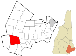 Location in Rockingham County and the state of New Hampshire. | |
| Coordinates: 42°52′50″N 71°19′38″W | |
| Country | United States |
| State | New Hampshire |
| County | Rockingham |
| Incorporated | 1827 |
| Villages | |
| Government | |
| • Town Council | Members
|
| • Town Administrator | David Caron |
| Area | |
| • Total | 36.3 sq mi (94.0 km2) |
| • Land | 35.5 sq mi (91.9 km2) |
| • Water | 0.8 sq mi (2.1 km2) 2.26% |
| Elevation | 282 ft (86 m) |
| Population (2020)[2] | |
| • Total | 34,317 |
| • Density | 967/sq mi (373.5/km2) |
| Time zone | UTC-5 (Eastern) |
| • Summer (DST) | UTC-4 (Eastern) |
| ZIP code | 03038 |
| Area code | 603 |
| FIPS code | 33-17940 |
| GNIS feature ID | 0873578 |
| Website | www |
The Derry census-designated place, with a 2020 population of 22,879, occupies the central part of the town, extending from Derry's downtown in the west to the town of Hampstead in the east. The town also includes the village of East Derry.
History
The area was first settled by Scots-Irish families in 1719 as part of the town of Londonderry, as were present-day Windham and portions of Manchester, Salem and Hudson. The town of Derry was formed in 1827 from the eastern portion of Londonderry and was named, like Londonderry, after the city of Derry in Ireland,[4] the Irish word Doire meaning "oak grove". The first potato planted in the United States was sown in Derry in the town's common field in 1719.[5] The town is the location of two of America's oldest private schools, Pinkerton Academy, founded in 1814 and still in operation, and the closed Adams Female Seminary.
Derry was once a linen[6] and leather-making center until New England textile industries moved south in the 20th century. As recently as World War II, Derry was also a sleepy farming community. From 1900 to 1911, poet Robert Frost lived with his family on a farm in Derry purchased for him by his grandfather. The Robert Frost Farm is now a National Historic Landmark and state park and is open to the public for tours, poetry readings and other cultural events from spring through fall.[7]
The post-war suburban boom, the town's proximity to Boston in the south and Manchester to the northwest, and the construction of Interstate 93 through town led to a huge population boom. After the 1990s, this growth disappeared, with the population remaining essentially unchanged since 2000.
The Manchester and Lawrence branch of the Boston and Maine Railroad ran through Derry, but is now abandoned, with most of the line in town now a rail trail. The New Hampshire Department of Transportation stated in its I-93 corridor transit study[8] and its 2012 statewide rail plan[9] that it could be feasible to reopen the line.
Historical postcards
 Broadway c. 1905
 Birch Street c. 1905
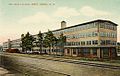 HEH Shoe Factory in 1909
 Hildreth Hall in 1914
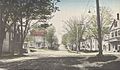 Thornton Square c. 1915


Geography
According to the United States Census Bureau, the town has a total area of 36.3 square miles (94.0 km2), of which 35.5 square miles (91.9 km2) are land and 0.81 square miles (2.1 km2) are water, comprising 2.26% of the town.[1] Derry is drained by Beaver Brook, a south-flowing tributary of the Merrimack River. Island Pond is on the southeast border of the town and drains to the Spicket River, another tributary of the Merrimack. A small section along the northern border of town drains north to the Exeter River, part of the Piscataqua River watershed.[10] The highest point in the town is Warner Hill, at 605 feet (184 m) above sea level, where from the top one can see the Boston skyline on a clear day.
Derry is crossed by Interstate 93 and New Hampshire routes 28, 28 Bypass, and 102.
Derry's downtown is located near the town's western border at the intersection of Routes 102 and 28, and the village of East Derry is located approximately 2 miles (3 km) to the east and close to the geographic center of the town. Both areas are part of the Derry census-designated place.
Adjacent municipalities
- Chester, New Hampshire (north)
- Sandown, New Hampshire (northeast)
- Hampstead, New Hampshire (east)
- Atkinson, New Hampshire (southeast)
- Salem, New Hampshire (southeast)
- Windham, New Hampshire (south)
- Londonderry, New Hampshire (west)
- Auburn, New Hampshire (northwest)
Climate
Derry has a four-season humid continental climate (Köppen Dfa), with long, cold, snowy winters, and very warm and somewhat humid summers; spring and fall in between are crisp and relatively brief transitions. Precipitation is well-spread throughout the year, including snowfall in the winter.
Demographics
| Historical population | |||
|---|---|---|---|
| Census | Pop. | %± | |
| 1830 | 2,178 | — | |
| 1840 | 2,034 | −6.6% | |
| 1850 | 1,850 | −9.0% | |
| 1860 | 1,995 | 7.8% | |
| 1870 | 1,809 | −9.3% | |
| 1880 | 2,140 | 18.3% | |
| 1890 | 2,604 | 21.7% | |
| 1900 | 3,583 | 37.6% | |
| 1910 | 5,123 | 43.0% | |
| 1920 | 5,382 | 5.1% | |
| 1930 | 5,131 | −4.7% | |
| 1940 | 5,400 | 5.2% | |
| 1950 | 5,826 | 7.9% | |
| 1960 | 6,987 | 19.9% | |
| 1970 | 11,712 | 67.6% | |
| 1980 | 18,875 | 61.2% | |
| 1990 | 29,603 | 56.8% | |
| 2000 | 34,021 | 14.9% | |
| 2010 | 33,109 | −2.7% | |
| 2020 | 34,317 | 3.6% | |
| U.S. Decennial Census[2][11] | |||
As of the census of 2020,[12] there were 34,317 people residing in the town. The racial makeup of the town was 88.1% White, 2.3% African American, 1.8% American Indian and Alaska Native, 2.3% Asian, 0.1% Pacific Islander, 0.9% some other race, and 1.7% from two or more races. 4.6% of the population were Hispanic or Latino of any race.
As of the census of 2010, there were 12,537 households, out of which 35.0% had children under the age of 18 living with them, 52.4% had a married couple living together, 12.2% had a woman whose husband does not live with her, and 30.1% were non-families. 23.0% of all households were made up of individuals, and 6.4% had someone living alone who was 65 years of age or older. The average household size was 2.62, and the average family size was 3.10.
In the town, the population was spread out, with 24.7% under the age of 18, 9.3% from 18 to 24, 27.0% from 25 to 44, 30.4% from 45 to 64, and 8.7% who were 65 years of age or older. The median age was 38.2 years. For every 100 females, there were 98.6 males. For every 100 females age 18 and over, there were 95.9 males.
At the 2000 census the median income for a household in the town was $54,634, and the median income for a family was $61,625. Males had a median income of $41,271 versus $30,108 for females. The per capita income for the town was $22,315. 4.6% of the population and 3.3% of families were below the poverty line. Out of the total people living in poverty, 5.0% were under the age of 18 and 7.1% were 65 or older.
Government
| Year | Democratic | Republican | Third Parties |
|---|---|---|---|
| 2020 | 45.91% 8,215 | 52.60% 9,412 | 1.49% 267 |
| 2016 | 40.35% 6,825 | 54.62% 9,237 | 5.03% 851 |
| 2012 | 46.87% 7,612 | 51.42% 8,350 | 1.71% 277 |
| 2008 | 47.86% 7,527 | 50.51% 7,944 | 1.63% 257 |
| 2004 | 45.33% 6,760 | 53.90% 8,038 | 0.77% 114 |
| 2000 | 45.57% 5,530 | 50.21% 6,093 | 4.22% 512 |
| 1996 | 45.55% 4,814 | 42.61% 4,503 | 11.85% 1,252 |
| 1992 | 32.57% 3,962 | 39.04% 4,750 | 28.39% 3,454 |
| 1988 | 30.72% 2,845 | 67.52% 6,253 | 1.76% 163 |
| 1984 | 26.24% 1,972 | 73.19% 5,501 | 0.57% 43 |
| 1980 | 23.53% 1,519 | 62.89% 4,060 | 13.58% 877 |
| 1976 | 40.91% 2,272 | 56.61% 3,144 | 2.48% 138 |
| 1972 | 30.17% 1,526 | 67.69% 3,424 | 2.14% 108 |
| 1968 | 35.03% 1,476 | 56.74% 2,391 | 8.23% 347 |
| 1964 | 53.09% 1,882 | 46.91% 1,663 | 0.00% 0 |
| 1960 | 39.24% 1,313 | 60.76% 2,033 | 0.00% 0 |
In the New Hampshire Senate, Derry is in the 19th District and is currently represented by Republican Regina Birdsell. On the Executive Council of New Hampshire, Derry is in District 3 and is currently represented by Republican Janet Stevens. In the U.S. House of Representatives, Derry is included in New Hampshire's 1st congressional district and is currently represented by Democrat Chris Pappas.
Derry is part of a reliably Republican belt of dense, populous towns along Interstate 93 near the Massachusetts border. Derry leans Republican in presidential elections, and has even trended rightwards as of late. Bill Clinton did manage to carry the town with a plurality of the vote in 1996. No Democrat has won a majority of Derry’s voters since Lyndon B. Johnson’s landslide election in 1964.
Economy
Top employers
According to the town's 2020 Comprehensive Annual Financial Report, the top employers in the town are the following:[14]
| # | Employer | # of employees |
|---|---|---|
| 1 | Derry Cooperative School District | 620 |
| 2 | HCA Health Services of New Hampshire (Parkland Medical Center) | 532 |
| 3 | Pinkerton Academy | 462 |
| 4 | Town of Derry | 364 |
| 5 | Walmart | 265 |
| 6 | Hannaford | 142 |
| 7 | Shaw's | 105 |
| 8 | Fireye | 100 |
| 9 | Benson's Hardware | 50 |
| 10 | Total Air Supply | 40 |
Transportation
Five New Hampshire state highways and one Interstate Highway cross the town of Derry:
- NH 28 enters from Salem in the south, follows Rockingham Road north to the southern limit of the town's main business district, then turns west along with Rockingham Road toward an intersection with Windham Road and Kendall Pond Road (Shute's Corner), and then north to follow Birch Street. After crossing NH 102, it becomes Crystal Avenue, and finally at Tsienneto Road changes names again to Manchester Road before entering Londonderry in the western part of town.
- NH 28 Bypass, known locally as "The Bypass", begins at South Main Street where NH 28 turns along with Rockingham Road, and continues on South Main Street, North Main Street, and Londonderry Turnpike before crossing the extreme northwestern corner of town and entering Auburn.
- NH 102 enters in the west from Londonderry, where it is known locally as Broadway. Running southwest to northeast, it crosses North and South Main Street (NH 28 Bypass) and East Derry Road at a traffic circle in the center of town (Danforth Circle), from where it follows Chester Road to the northern border with the town of Chester.
- NH 111 crosses the extreme southeastern corner of town, entering from Salem in the south, and passing into Atkinson in the east. There is only one intersection in the town, with Island Pond Road, with NH 111 spending less than 1/2 mile in Derry.
- NH 121 crosses the extreme northeastern corner of town for a few hundred feet between Hampstead and Sandown. There are no intersections on this stretch of NH 121 that connect to the rest of Derry, though Hampstead Road intersects NH 121 a few feet from the Derry border with Hampstead some distance to the south.
- Interstate 93 crosses the southwestern corner of Derry, for less than 1 mile. There are no interchanges in the town, but the interchange with NH 102 in Londonderry is less than 1,000 feet from the town line.
The nearest air transport is Manchester–Boston Regional Airport. There is currently no passenger rail service in Derry, though a former train depot in the center of town has been converted to a hub for the main commercial district in town.
Education

Public schools
- Administration:
- Elementary:
- Middle:
- Gilbert H. Hood Middle School
- West Running Brook Middle School
Private schools
- Pinkerton Academy, serving as the public high school for Derry, Chester, Hampstead, Auburn, Hooksett, and Candia
- Nutfield Cooperative School (pre-school and kindergarten)
- Saint Thomas Aquinas School (pre-kindergarten through grade 8)
- Derry Montessori School (age 3 through grade 3)
- Calvary Christian School operated from 1970 to 2009 and educated an average of 400 students in grades K–12.
- Next Charter School (grades 9 through 12)
Media
Derry is home to three media sources, the weekly Derry News, which is owned by The Eagle-Tribune, the weekly Nutfield News, which is locally owned by Nutfield Publishing, and television station WWJE-DT, owned by Univision Communications. Derry is located within the Boston television market and the Manchester radio market. Derry Community Television, also known as DerryCAM, is the town's public-access television station on local cable TV.
Notable people

- Samantha Brown (born 1970), former host of Travel Channel, seller on QVC[15]
- Caleb Chapman (born 1973), musician[16]
- Charles Cogswell Doe (1830–1896), Chief Justice of the Supreme Court of New Hampshire, born in Derry[17]
- Tricia Dunn-Luoma (born 1974), hockey player; Olympic gold medalist[18]
- Charles Miller Floyd (1861–1923), 51st governor of New Hampshire[19]
- Robert Frost (1874–1963), four-time Pulitzer Prize-winning poet (to date, the only poet to achieve this feat)[20]
- Brendan James (born 1979), singer-songwriter, pianist
- Priscilla Lane (1915–1995), actress
- David Nelson (born 1974), world-record-holding video game competitor
- William Patterson (1789–1838), U.S. congressman[21]
- Joe Seiders (born 1980), musician
- Alan B. Shepard Jr. (1923–1998), astronaut, first American in space, and as a member of Apollo 14 one of 12 people to have walked on the Moon
- Pamela Smart (born 1967), convicted conspirator to murder
- John Stark (1728–1822), Continental Army major general in the Revolutionary War
- Aaron Fletcher Stevens (1819–1887), brigadier general, U.S. congressman
- Matt Taven (born 1985), professional wrestler
- Paul Thompson (born 1988), hockey player
- Matthew Thornton (1714–1803), Irish-born Founding Father of the United States who signed the United States Declaration of Independence as a representative of New Hampshire
- Nikki Tilroe (1941–2005), performer, puppeteer
- Ryan Tuerck (born 1985), Formula D Drift professional driver
Sites of interest
- Adams Memorial Building[22]
- Derry Historical Society and Museum [23]
- Robert Frost Farm, National Historic Landmark
- Taylor Mill State Historic Site[24]
- Rockingham Recreational Trail,[25] rail trail to Fremont
Sister cities
 Cherepovets, Vologda Oblast, Russia[26]
References
- "2021 U.S. Gazetteer Files – New Hampshire". United States Census Bureau. Retrieved December 21, 2021.
- "Derry town, Rockingham County, New Hampshire: 2020 DEC Redistricting Data (PL 94-171)". U.S. Census Bureau. Retrieved December 21, 2021.
- "Derry, NH". NewHampshire.com. Archived from the original on August 30, 2010. Retrieved January 27, 2011.
- Gannett, Henry (1905). The Origin of Certain Place Names in the United States. Govt. Print. Off. p. 104.
- Brown, Janice (October 18, 2014). "New Hampshire: First in the Nation Potato". Cow Hampshire Blog. Retrieved September 5, 2019.
- Belknap, Jeremy (1813). The History of New Hampshire, volume II. Boston: Bradford and Read. p. 32.
- "Frost, Robert, Homestead". National Park Service - National Historic Landmarks Program. Archived from the original on June 6, 2011. Retrieved January 27, 2011.
- HNTB Corporation (November 2009). "I-93 Corridor Multi-Modal Transit Investment Study" (PDF). New Hampshire Department of Transportation. Retrieved September 28, 2015.
- "New Hampshire State Rail Plan" (PDF). New Hampshire Department of Transportation. 2012. Retrieved September 28, 2015.
- Foster, Debra H.; Batorfalvy, Tatianna N.; Medalie, Laura (1995). Water Use in New Hampshire: An Activities Guide for Teachers. U.S. Department of the Interior and U.S. Geological Survey.
- "Census of Population and Housing". Census.gov. Retrieved June 4, 2016.
- "Profile of General Population and Housing Characteristics: 2010 Demographic Profile Data, Derry town, New Hampshire". United States Census Bureau. Retrieved September 20, 2011.
- "Election Results". sos.nh.gov.
- "Town of Derry, New Hampshire: Comprehensive Annual Financial Report for the Fiscal Year Ending June 30, 2020" (PDF). 2020. p. 137.
- "Samantha Brown". New Hampshire.com. Retrieved March 12, 2014.
- "Younger Lions: Caleb Chapman". Jazzed. 20 September 2011. Retrieved March 12, 2014.
- Reid, John Phillip (1967). Chief Justice: The Judicial World of Charles Doe. Harvard University Press. p. 28. ISBN 978-0674114005.
- "Tricia Dunn-Luoma". Sports Reference LLC. Archived from the original on April 17, 2020. Retrieved March 12, 2014.
- Marquis, Albert Nelson (1915). Who's who in New England: A Biographical Dictionary of Leading Living Men and Women of the States of Maine, New Hampshire, Vermont, Massachusetts, Rhode Island and Connecticut. A.N. Marquis. p. 415.
- "Robert Frost Farm State Historic Site". Parks & Recreation New Hampshire. Archived from the original on March 13, 2014. Retrieved March 12, 2014.
- "Patterson, William (1789 - 1838)". Biographical Directory of the United States Congress. Retrieved March 12, 2014.
- Adams Memorial Opera House
- Derry Historical Society & Museum
- Taylor Mill State Historic Site, a reconstructed water-powered sawmill
- Rockingham Recreational Trail
- "Derry councilors accept gift from 'sister' city".
Further reading
- Richard Holmes, Town Historian, "Town of Derry"
- Rev. Edward L. Parker, History of Londonderry, Comprising the Towns of Derry and Londonderry; Perkins & Whipple; Boston 1851
- A. J. Coolidge & J. B. Mansfield, A History and Description of New England; Boston 1859
External links
- Official website
- Derry Public Library
- Derry News, covering Derry and Londonderry
- Nutfield News
- Derry Community Access Media
- New Hampshire Economic and Labor Market Information Bureau Profile
Places adjacent to Derry, New Hampshire | |
|---|---|
Municipalities and communities of Rockingham County, New Hampshire, United States | ||
|---|---|---|
County seat: Brentwood | ||
| City |  | |
| Towns |
| |
| CDPs | ||
| Other villages | ||
| ||
| Authority control |
|
|---|
На других языках
[de] Derry (New Hampshire)
Derry ist eine Stadt (Town) im Rockingham County des Bundesstaates New Hampshire im Nordosten der Vereinigten Staaten. Bei der letzten amtlichen Volkszählung im Jahr 2010 hatte Derry 33.109 Einwohner und war somit die größte Stadt des Rockingham County sowie die viertgrößte Stadt von New Hampshire. 2020 wurden 34.317 Einwohner in Derry gezählt.[1] Derry wurde erst am 2. Juli 1827 gegründet, vorher gehörte das Gebiet zur Stadt Londonderry.- [en] Derry, New Hampshire
[ru] Дерри (Нью-Гэмпшир)
Дерри (англ. Derry) — городок в округе Рокингхэм, штат Нью-Гэмпшир, США. По данным переписи населения в 2000 году численность города — 34.021 человек. Несмотря на то, что это не город, а городок (посёлок), Дерри является четвертым по численности населения среди всех городов в штате Нью-Гэмпшир.Другой контент может иметь иную лицензию. Перед использованием материалов сайта WikiSort.org внимательно изучите правила лицензирования конкретных элементов наполнения сайта.
WikiSort.org - проект по пересортировке и дополнению контента Википедии