world.wikisort.org - USA
Concord (/ˈkɒŋkərd/) is the capital city of the U.S. state of New Hampshire and the seat of Merrimack County. As of the 2020 census the population was 43,976,[3] making it the third largest city in New Hampshire behind Manchester and Nashua.
Concord, New Hampshire | |
|---|---|
State capital city | |
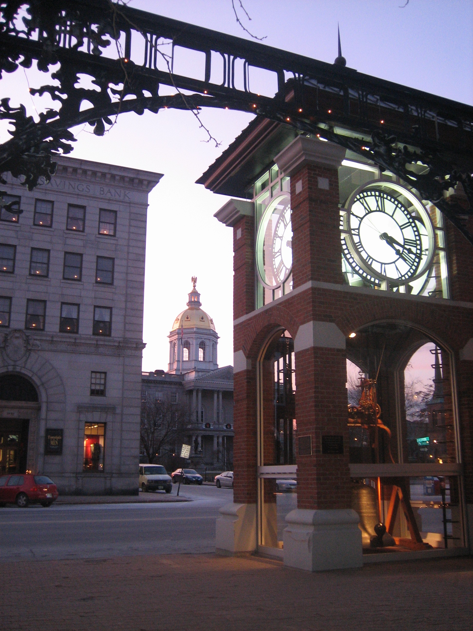 The New Hampshire State House as seen from Eagle Square | |
 Flag  Seal | |
 Location in Merrimack County, New Hampshire | |
 Concord Location in New Hampshire, United States & North America  Concord Concord (the United States)  Concord Concord (North America) | |
| Coordinates: 43°12′24″N 71°32′17″W | |
| Country | |
| State | |
| County | Merrimack |
| Region | New England |
| Settled | 1659[1] |
| Incorporated | 1733[1] |
| Government | |
| • Type | Mayor–council |
| • Mayor | Jim Bouley |
| • City Council | Members
|
| • City Manager | Thomas J. Aspell, Jr. |
| Area | |
| • Total | 67.19 sq mi (174.02 km2) |
| • Land | 63.96 sq mi (165.66 km2) |
| • Water | 3.23 sq mi (8.36 km2) |
| Elevation | 288 ft (88 m) |
| Population (2020)[3] | |
| • Total | 43,976 |
| • Density | 687.52/sq mi (265.46/km2) |
| • μSA | 155,238[4] |
| Time zone | UTC−5 (Eastern) |
| • Summer (DST) | UTC−4 (Eastern) |
| ZIP Codes | 03301, 03302, 03303, 03305 |
| Area code | 603 |
| FIPS code | 33-14200 |
| GNIS feature ID | 873303 |
| Primary airports | Concord Municipal Airport |
| Interstates | |
| Bus service | CAT, Concord Coach Lines |
| Website | www |
The village of Penacook lies at the northern boundary of the city limits. The city is home to the University of New Hampshire School of Law, New Hampshire's only law school; St. Paul's School, a private preparatory school; NHTI, a two-year community college; the New Hampshire Police Academy; and the New Hampshire Fire Academy. Concord's Old North Cemetery is the final resting place of Franklin Pierce, 14th President of the United States.[5]
History

The area that would become Concord was originally settled thousands of years ago by Abenaki Native Americans called the Pennacook.[6]: 65 The tribe fished for migrating salmon, sturgeon, and alewives with nets strung across the rapids of the Merrimack River. The stream was also the transportation route for their birch bark canoes, which could travel from Lake Winnipesaukee to the Atlantic Ocean. The broad sweep of the Merrimack River valley floodplain provided good soil for farming beans, gourds, pumpkins, melons and maize.
The area was first settled by Europeans in 1659 as Penacook, after the Abenaki word "pannukog" meaning "bend in the river," referencing the steep bends of the Merrimack River through the area.[1] On January 17, 1725, the Province of Massachusetts Bay, which then claimed territories west of the Merrimack, granted the Concord area as the Plantation of Penacook.[6]: 107 It was settled between 1725 and 1727 by Captain Ebenezer Eastman and others from Haverhill, Massachusetts. On February 9, 1734, the town was incorporated as "Rumford",[6]: 147 from which Sir Benjamin Thompson, Count Rumford, would take his title. It was renamed "Concord" in 1765 by Governor Benning Wentworth following a bitter boundary dispute between Rumford and the town of Bow; the city name was meant to reflect the new concord, or harmony, between the disputant towns.[7] Citizens displaced by the resulting border adjustment were given land elsewhere as compensation. In 1779, New Pennacook Plantation was granted to Timothy Walker Jr. and his associates at what would be incorporated in 1800 as Rumford, Maine, the site of Pennacook Falls.
Concord grew in prominence throughout the 18th century, and some of the earliest houses from this period survive at the northern end of Main Street.[8] In the years following the Revolution, Concord's central geographical location made it a logical choice for the state capital, particularly after Samuel Blodget in 1807 opened a canal and lock system to allow vessels passage around the Amoskeag Falls downriver, connecting Concord with Boston by way of the Middlesex Canal. In 1808, Concord was named the official seat of state government,[6]: 324–326 and in 1816 architect Stuart Park was commissioned to design a new capitol building for the state legislature on land sold to the state by local Quakers.[9] Construction on the State House was completed in 1819, and it remains the oldest capitol in the nation in which the state's legislative branches meet in their original chambers. Concord was also named the seat of Merrimack County in 1823, and the Merrimack County Courthouse was constructed in 1857 in the North End at the site of the Old Town House.[10]
In the early 19th century, much of the city's economy was dominated by furniture-making, printing, and granite quarrying; granite had become a popular building material for many monumental halls in the early United States, and Concord granite was used in the construction of both the New Hampshire State House and the Library of Congress in Washington, D.C.[11] In 1828, Lewis Downing joined J. Stephens Abbot to form Abbot and Downing.[6]: 339–340 Their most famous product was their Concord coach, widely used in the development of the American West, and their enterprise largely boosted and changed the city economy in the mid-19th century. In subsequent years, Concord would also become a hub for the railroad industry, with Penacook a textile manufacturing center using water power from the Contoocook River. The city also around this time started to become a center for the emerging healthcare industry, with New Hampshire State Hospital opening in 1842 as one of the first psychiatric hospitals in the United States.[12] The State Hospital continued to expand throughout the following decades, and in 1891 Concord Hospital opened its doors as Margaret Pillsbury General Hospital, the first general hospital in the state of New Hampshire.[13]
Concord's economy changed once again in the 20th century with the declining railroad and textile industry. The city developed into a center for national politics due to New Hampshire's first-in-the-nation primary, and many presidential candidates still visit the Concord area during campaign season.[14] The city also developed an identity within the emerging space industry, with the McAuliffe-Shepard Discovery Center opening in 1990 to commemorate Alan Shepard, the first American in space from nearby Derry, and Christa McAuliffe, a teacher at Concord High School who died in the 1986 Space Shuttle Challenger disaster. Today, Concord remains a center for politics, law, healthcare, and insurance companies.
 First Concord Bridge, 1795
 State House c. 1906
 Main Street c. 1908
 City Hall in 1913
 Old Library c. 1915
 Old Post Office in 1910


Geography


Concord is located in south-central New Hampshire at 43°12′24″N 71°32′17″W (43.2070, −71.5371).[15] It is 38 miles (61 km) north of the Massachusetts border, 40 miles (64 km) west of the Maine border, 54 miles (87 km) east of the Vermont border, and 170 miles (270 km) south of the Canadian border at Pittsburg.
According to the United States Census Bureau, the city has a total area of 67.2 square miles (174.0 km2). 64.0 square miles (165.7 km2) of it are land and 3.2 square miles (8.4 km2) of it are water, comprising 4.81% of the city.[16] Concord is drained by the Merrimack River. Penacook Lake, the largest lake in the city and its main source of water, is in the west. The highest point in Concord is 860 feet (260 m) above sea level on Oak Hill, just west of the hill's 970-foot (300 m) summit in neighboring Loudon.
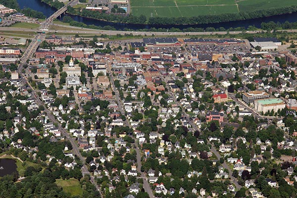
Concord lies fully within the Merrimack River watershed[17] and is centered on the river, which runs from northwest to southeast through the city. Downtown is located on a low terrace to the west of the river, with residential neighborhoods climbing hills to the west and extending southwards towards the town of Bow. To the east of the Merrimack, atop a 100-foot (30 m) bluff, is a flat, sandy plain known as Concord Heights, which has seen most of the city's commercial development since 1960. The eastern boundary of Concord (with the town of Pembroke) is formed by the Soucook River, a tributary of the Merrimack. The Turkey River winds through the southwestern quarter of the city, passing through the campus of St. Paul's School before entering the Merrimack River in Bow. In the northern part of the city, the Contoocook River enters the Merrimack at the village of Penacook.
Concord is 16 miles (26 km) north of Manchester, New Hampshire's largest city, and 66 miles (106 km) north of Boston.
Villages
The city of Concord is made up of its downtown, including its North End and South End neighborhoods, plus the four distinct villages of Penacook, Concord Heights, East Concord, and West Concord.[18]
Adjacent municipalities
- Canterbury (north)
- Loudon (northeast)
- Pembroke (southeast)
- Bow (south)
- Hopkinton (west)
- Webster (northwest)
- Boscawen (north-northwest)
Climate
Concord, as with much of New England, is within the humid continental climate zone (Köppen Dfb), with long, cold, snowy winters, warm (and at times humid) summers, and relatively brief autumns and springs. In winter, successive storms deliver moderate to at times heavy snowfall amounts, contributing to the relatively reliable snow cover. In addition, lows reach below 0 °F (−18 °C) on an average 15 nights per year, and the city straddles the border between USDA Hardiness Zone 5b and 6a.[19] However, thaws are frequent, with one to three days per month with 50 °F (10 °C)+ highs from December to February. Summer can bring stretches of humid conditions as well as thunderstorms, and there is an average of 12 days of 90 °F (32 °C)+ highs annually. The window for freezing temperatures on average begins on September 27 and expires on May 14.[20]
The monthly daily average temperature range from 20.6 °F (−6.3 °C) in January to 70.0 °F (21.1 °C) in July. Temperature extremes have ranged from −37 °F (−38 °C) in February 1943 to 102 °F (39 °C) in July 1966.
| Climate data for Concord Municipal Airport, New Hampshire (1991−2020 normals,[lower-alpha 1] extremes 1868–present)[lower-alpha 2] | |||||||||||||
|---|---|---|---|---|---|---|---|---|---|---|---|---|---|
| Month | Jan | Feb | Mar | Apr | May | Jun | Jul | Aug | Sep | Oct | Nov | Dec | Year |
| Record high °F (°C) | 72 (22) |
74 (23) |
89 (32) |
95 (35) |
98 (37) |
101 (38) |
102 (39) |
101 (38) |
98 (37) |
92 (33) |
80 (27) |
73 (23) |
102 (39) |
| Mean maximum °F (°C) | 52 (11) |
54 (12) |
66 (19) |
82 (28) |
90 (32) |
93 (34) |
94 (34) |
92 (33) |
89 (32) |
79 (26) |
69 (21) |
57 (14) |
96 (36) |
| Average high °F (°C) | 31.6 (−0.2) |
34.8 (1.6) |
43.6 (6.4) |
57.5 (14.2) |
69.3 (20.7) |
77.8 (25.4) |
83.0 (28.3) |
81.7 (27.6) |
73.7 (23.2) |
60.9 (16.1) |
48.4 (9.1) |
37.1 (2.8) |
58.3 (14.6) |
| Daily mean °F (°C) | 22.3 (−5.4) |
24.7 (−4.1) |
33.4 (0.8) |
45.4 (7.4) |
56.7 (13.7) |
65.8 (18.8) |
71.1 (21.7) |
69.5 (20.8) |
61.4 (16.3) |
49.3 (9.6) |
38.6 (3.7) |
28.3 (−2.1) |
47.2 (8.4) |
| Average low °F (°C) | 12.9 (−10.6) |
14.7 (−9.6) |
23.3 (−4.8) |
33.3 (0.7) |
44.1 (6.7) |
53.7 (12.1) |
59.2 (15.1) |
57.2 (14.0) |
49.0 (9.4) |
37.8 (3.2) |
28.7 (−1.8) |
19.5 (−6.9) |
36.1 (2.3) |
| Mean minimum °F (°C) | −9 (−23) |
−7 (−22) |
2 (−17) |
19 (−7) |
29 (−2) |
39 (4) |
47 (8) |
44 (7) |
32 (0) |
22 (−6) |
12 (−11) |
−1 (−18) |
−12 (−24) |
| Record low °F (°C) | −35 (−37) |
−37 (−38) |
−20 (−29) |
4 (−16) |
21 (−6) |
30 (−1) |
35 (2) |
29 (−2) |
20 (−7) |
10 (−12) |
−17 (−27) |
−24 (−31) |
−37 (−38) |
| Average precipitation inches (mm) | 2.80 (71) |
2.75 (70) |
3.28 (83) |
3.43 (87) |
3.47 (88) |
3.77 (96) |
3.62 (92) |
3.63 (92) |
3.63 (92) |
4.43 (113) |
3.44 (87) |
3.70 (94) |
41.95 (1,066) |
| Average snowfall inches (cm) | 17.1 (43) |
16.9 (43) |
13.6 (35) |
2.5 (6.4) |
0.0 (0.0) |
0.0 (0.0) |
0.0 (0.0) |
0.0 (0.0) |
0.0 (0.0) |
0.8 (2.0) |
2.5 (6.4) |
14.3 (36) |
67.7 (172) |
| Average precipitation days (≥ 0.01 in) | 11.2 | 10.0 | 11.5 | 11.4 | 12.4 | 12.8 | 10.9 | 9.9 | 9.3 | 10.6 | 10.8 | 12.0 | 132.8 |
| Average snowy days (≥ 0.1 in) | 8.1 | 7.6 | 5.2 | 1.3 | 0.0 | 0.0 | 0.0 | 0.0 | 0.0 | 0.2 | 1.6 | 6.3 | 30.3 |
| Average relative humidity (%) | 67.9 | 66.0 | 64.8 | 62.0 | 65.0 | 70.9 | 71.8 | 74.5 | 76.3 | 72.8 | 73.3 | 72.3 | 69.8 |
| Mean monthly sunshine hours | 162.8 | 171.8 | 210.5 | 223.2 | 258.4 | 274.3 | 295.8 | 261.9 | 214.7 | 183.4 | 127.8 | 134.8 | 2,519.4 |
| Percent possible sunshine | 56 | 58 | 57 | 56 | 57 | 60 | 64 | 61 | 57 | 54 | 44 | 48 | 56 |
| Average ultraviolet index | 1 | 2 | 4 | 5 | 7 | 8 | 8 | 7 | 6 | 3 | 2 | 1 | 5 |
| Source 1: NOAA (relative humidity and sun 1961–1990)[20][21][22] | |||||||||||||
| Source 2: Weather Atlas (UV)[23] | |||||||||||||
Demographics
| Year | Pop. | ±% |
|---|---|---|
| 1767 | 752 | — |
| 1775 | 1,052 | +39.9% |
| 1786 | 1,402 | +33.3% |
| 1790 | 1,747 | +24.6% |
| 1800 | 2,052 | +17.5% |
| 1810 | 2,393 | +16.6% |
| 1820 | 2,838 | +18.6% |
| 1830 | 3,720 | +31.1% |
| 1840 | 4,897 | +31.6% |
| 1850 | 8,576 | +75.1% |
| 1860 | 10,896 | +27.1% |
| 1870 | 12,241 | +12.3% |
| 1880 | 13,843 | +13.1% |
| 1890 | 17,004 | +22.8% |
| 1900 | 19,632 | +15.5% |
| 1910 | 21,497 | +9.5% |
| 1920 | 22,167 | +3.1% |
| 1930 | 25,228 | +13.8% |
| 1940 | 27,171 | +7.7% |
| 1950 | 27,988 | +3.0% |
| 1960 | 28,991 | +3.6% |
| 1970 | 30,022 | +3.6% |
| 1980 | 30,400 | +1.3% |
| 1990 | 36,006 | +18.4% |
| 2000 | 40,687 | +13.0% |
| 2010 | 42,695 | +4.9% |
| 2020 | 43,976 | +3.0% |
| 2021 | 44,006 | +0.1% |
| Source: U.S. Decennial Census[24][failed verification] Population estimate[25] 1767-1786: NH Provincial & State Papers[27] | ||
As of the census of 2020, there were 43,976 people residing in the city. The population density was 687.7 people per square mile (265.5/km2). At the 2010 Census there were 42,695 residents and 10,052 families in the city, as well as 18,852 housing units at an average density of 293.2 per square mile (113.2/km2). The racial makeup of the city in 2020 was 84.5% White, 4.9% Black or African American, 1.0% Native American, 4.9% Asian, 0.1% Pacific Islander, 0.4% from some other race, and 1.8% from two or more races. 4.9% of the population were Hispanic or Latino of any race.[28]
In 2010 there were 17,592 households, out of which 28.7% had children under the age of 18 living with them, 41.3% were headed by married couples living together, 11.6% had a female householder with no husband present, and 42.9% were non-families. 33.6% of all households were made up of individuals, and 12.0% were someone living alone who was 65 years of age or older. The average household size was 2.26, and the average family size was 2.90.[28]
In the city, the population was spread out, with 20.7% under the age of 18, 9.3% from 18 to 24, 28.0% from 25 to 44, 28.2% from 45 to 64, and 13.8% who were 65 years of age or older. The median age was 39.4 years. For every 100 females, there were 98.5 males. For every 100 females age 18 and over, there were 96.9 males.[28]
For the period 2009–2011, the estimated median annual income for a household in the city was $52,695, and the median income for a family was $73,457. Male full-time workers had a median income of $49,228 versus $38,782 for females. The per capita income for the city was $29,296. About 5.5% of families and 10.1% of the population were below the poverty line, including 8.4% of those under age 18 and 5.5% of those age 65 or over.[29]
| Race | Percentage |
|---|---|
| White, not Hispanic or Latino | 84.5% |
| Asian | 4.9% |
| Black or African American | 4.9% |
| Hispanic or Latino | 3.1% |
Economy
Top employers
In 2020, the top employer in the city remained the State of New Hampshire, with over 6,000 employed workers, while the largest private employer was Concord Hospital,[31] with just under 3,000 employees. According to the City of Concord's Comprehensive Annual Financial Report,[32] the top 10 employers in the city for the Fiscal Year 2020 were:
| # | Employer | Employees |
|---|---|---|
| 1 | State of New Hampshire | 6,069 |
| 2 | Capital Region Health Care – Concord Hospital | 2,998 |
| 3 | Concord School District | 809 |
| 4 | City of Concord | 556 |
| 5 | Lincoln Financial Group | 405 |
| 6 | Market Basket | 405 |
| 7 | Genesis HealthCare | 385 |
| 8 | NHHEAF Network Organizations | 332 |
| 9 | St. Paul's School | 330 |
| 10 | Merrimack Valley School District | 328 |
Transportation
Highways
Interstate 89 and Interstate 93 are the two main interstate highways serving Concord, and join just south of the city limits. Interstate 89 links Concord with Lebanon and the state of Vermont to the northwest, while Interstate 93 connects the city to Plymouth, Littleton, and the White Mountains to the north and Manchester and Boston to the south. Interstate 393 is a spur highway leading east from Concord and merging with U.S. Route 4 as a direct route to New Hampshire's Seacoast region. North-south U.S. Route 3 serves as Concord's Main Street, while U.S. Route 202 and New Hampshire Route 9 cross the city from east to west. State routes 13 and 132 also serve the city: Route 13 leads southwest out of Concord towards Goffstown and Milford, while Route 132 travels north parallel to Interstate 93. New Hampshire Route 106 passes through the easternmost part of Concord, crossing I-393 and NH 9 before crossing the Soucook River south into the town of Pembroke. To the north, NH 106 leads to Loudon, Belmont and Laconia.
Railroads
Historically, Concord served as an important railroad terminal and station for the Boston and Maine Railroad. The former Concord Station was located at what is now a Burlington department store on Storrs Street. The station itself was built in 1860, but the fourth and most famous iteration of the station was built in 1885, which had a brick head house designed by Bradford L. Gilbert. The head house was demolished in 1959 and replaced by a smaller "McGinnis Era" station. By 1967, all passenger rail services to Concord had been discontinued.[33] For 13 months from 1980 to 1981, MBTA Commuter Rail ran two round trips a day between Boston and Concord. The service was discontinued after federal funding was pulled by the Reagan administration. Since then, there has not been any passenger rail service to Concord.[34]
In 2021, Amtrak announced their plan to implement new service between Boston and Concord by 2035.[35]
Bus
Local bus service is provided by Concord Area Transit (CAT), with three routes through the city.[36] Regional bus service provided by Concord Coach Lines and Greyhound Lines is available from the Concord Transportation Center at 30 Stickney Avenue next to Exit 14 on Interstate 93, with service south to Boston and points in between, as well as north to Littleton and northeast to Berlin.
Other modes
General aviation services are available through Concord Municipal Airport, located 2 miles (3 km) east of downtown. There is no commercial air service within the city limits; the nearest such airport is Manchester–Boston Regional Airport, 23 miles (37 km) to the south.
Complete Streets Improvement Project
Concord's downtown underwent a significant renovation between 2015 and 2016, during the city's "Complete Streets Improvement Project". At a proposed cost of $12 million, the project promised to deliver on categories of maintenance to aging infrastructure, improved accessibility, increased sustainability, a safer experience for walkers, bikers and motorists alike, and to stimulate economic growth in an increasingly idle downtown.[37][38] The main infrastructural change was reducing the four-lane street (two in each direction) to two lanes plus a turning lane in the center. The freed-up space would contribute to extra width for bikes to ride in either direction, increased curb size and an added median where there is no need for a turning lane.[39] Concord opted to add shared lane markings for bikes, rather than a dedicated protected bike lane.
By adding curb space, this project created new opportunities for pedestrians to enjoy the downtown. Many power lines were buried, and street trees, colorful benches, art installations, and other green spaces were added, all allowing people to reclaim a space long dominated by cars.[39] Main Street underwent serious traffic calming, including a road diet, increased diagonal parking, widening sidewalks, adding shared lane markings, adding trees, texturing medians and coloring crosswalks red.[40] Another aspect of the new construction was adding heated sidewalk capabilities, utilizing excess steam from the local Concord Steam plant, and minimizing sand and snow blowing needed during the winter months.[39]
Funding for Complete Streets came from a combination of $4,710,000 from a USDOT TIGER grant and the rest from the City of Concord.[39] The project was initially proposed as costing $7,850,000, but ran over budget due to overambitious ideas.[41] After scrapping some of the most expensive offenders, the budget ended up at $14.2 million, with the project actually coming in $1.1 million below that.[42] Although adding final aesthetic touches with the extra money were debated, the city council ended up deciding to save for financially straining years ahead.[42] The design was carried out by McFarland Johnson, IBI Group, and City of Concord Engineering.[37][39][43]
Notable people
Government
| Year | Democratic | Republican | Third Parties |
|---|---|---|---|
| 2020 | 64.99% 15,511 | 33.45% 7,983 | 1.57% 374 |
| 2016 | 58.09% 12,984 | 34.95% 7,812 | 6.95% 1,554 |
| 2012 | 65.07% 14,218 | 33.52% 7,325 | 1.41% 309 |
| 2008 | 64.81% 14,302 | 33.97% 7,496 | 1.23% 271 |
| 2004 | 60.16% 12,675 | 38.97% 8,210 | 0.87% 183 |
| 2000 | 56.25% 10,025 | 39.17% 6,981 | 4.58% 817 |
| 1996 | 60.03% 9,719 | 31.39% 5,082 | 8.58% 1,389 |
| 1992 | 49.19% 8,325 | 33.39% 5,651 | 17.41% 2,947 |
| 1988 | 46.95% 6,698 | 52.15% 7,439 | 0.90% 128 |
| 1984 | 41.69% 5,172 | 57.96% 7,190 | 0.35% 43 |
| 1980 | 33.92% 4,330 | 47.72% 6,092 | 18.36% 2,343 |
| 1976 | 43.62% 5,256 | 54.99% 6,627 | 1.39% 168 |
| 1972 | 35.76% 4,554 | 63.46% 8,082 | 0.78% 99 |
| 1968 | 40.55% 4,975 | 56.73% 6,960 | 2.71% 333 |
| 1964 | 64.27% 8,042 | 35.73% 4,470 | 0.00% 0 |
| 1960 | 40.21% 5,473 | 59.79% 8,137 | 0.00% 0 |
Concord is governed via the council-manager system. The city council consists of a mayor and 14 councilors, ten of which are elected to two-year terms representing each of the city wards, while the other four are elected at-large to four-year terms. The mayor is elected directly every two years. The current mayor is Jim Bouley, who has served 14 years as mayor and was elected to a record eighth term on November 2, 2021.[45]
According to the Concord city charter, the mayor chairs the council,[46] however has very few formal powers over the day-to-day management of the city.[46] The actual operations of the city are overseen by the city manager,[46] currently Thomas J. Aspell, Jr.[47] The current police chief is Bradley S. Osgood.[48]
In the New Hampshire Senate, Concord is in the 15th District, represented by Democrat Becky Whitley since December 2020. On the New Hampshire Executive Council, Concord is in the 2nd District, represented by Cinde Warmington, the sole Democrat on the council. In the United States House of Representatives, Concord is in New Hampshire's 2nd congressional district, represented by Democrat Ann McLane Kuster.
New Hampshire Department of Corrections operates the New Hampshire State Prison for Men and New Hampshire State Prison for Women[49] in Concord.

Concord leans strongly Democratic in presidential elections; the last Republican nominee to carry the city was then Vice President George H. W. Bush in 1988. Voter turnout was 72.7% in the 2020 general election,[50] down from 76.2% in 2016,[51] but still above the 2020 national turnout of 66.7%.[52]
Media
Newspapers and journals
- Concord Monitor (daily)
- Concord NH Patch (daily)
- New Hampshire Bulletin (daily)
- The Concord Insider (weekly)
- The Hippo (weekly)
Radio
- WKXL 1450 AM (News Talk Information)
- WNHN-LP 94.7 FM (Jazz, Blues, Progressive Talk)
- WEVO 89.1 FM (Public radio)
- WJYY 105.5 FM (Top 40)
- WAKC 102.3 FM (Contemporary Christian)
- WICX 102.7 FM (Catholic Radio)
The city is otherwise served by Manchester area stations. New Hampshire Public Radio is headquartered in Concord.
Television
- WPXG-TV (Channel 21) (Ion Television)
- Concord TV Public-access television cable TV station
Sites of interest

The New Hampshire State House, designed by architect Stuart Park and constructed between 1815 and 1818, is the oldest state house in which the legislature meets in its original chambers.[53] The building was remodeled in 1866, and the third story and west wing were added in 1910.
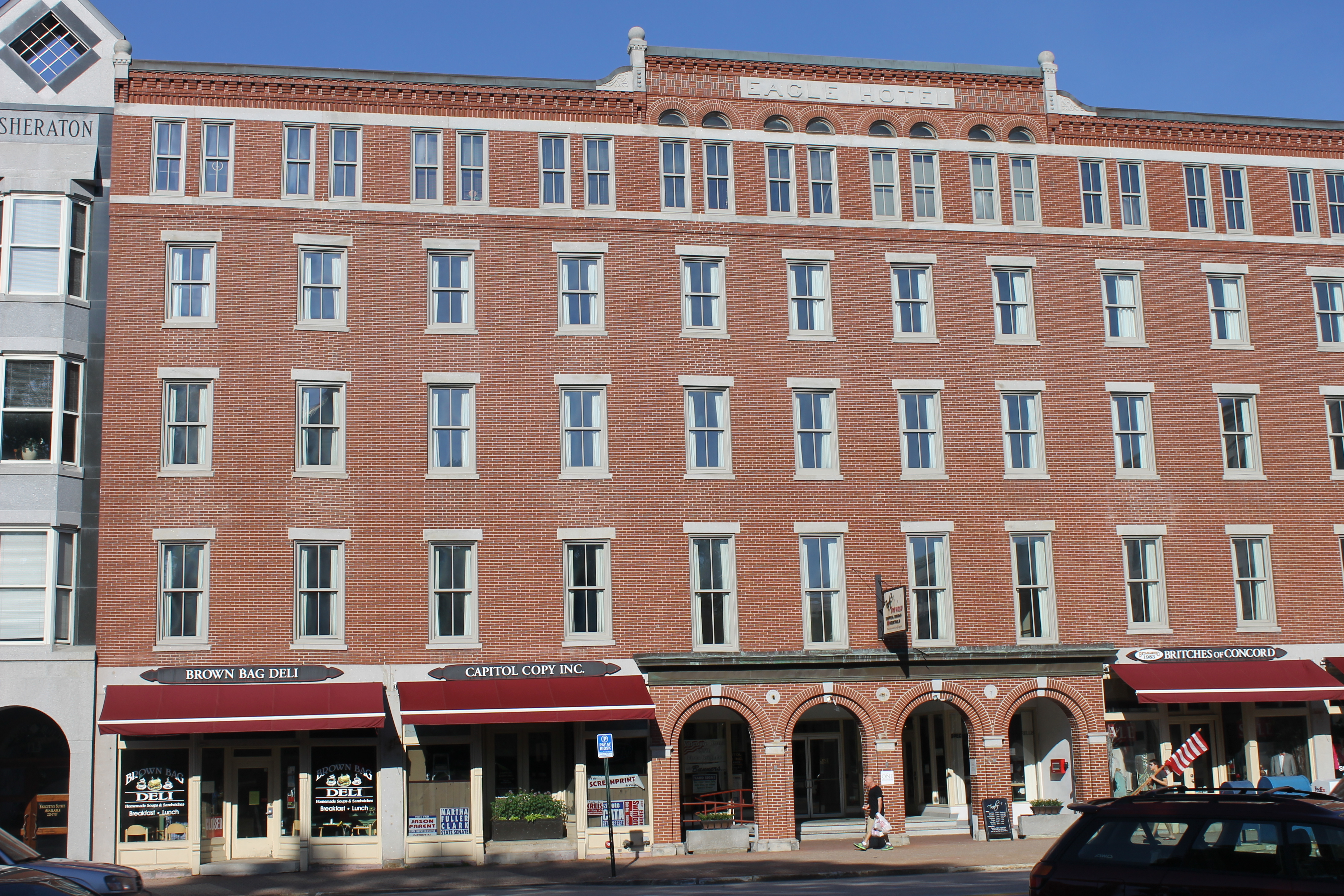
Across from the State House is the Eagle Hotel on Main Street, which has been a downtown landmark since its opening in 1827. U.S. Presidents Ulysses S. Grant, Rutherford Hayes, and Benjamin Harrison all dined there, and Franklin Pierce spent the night before departing for his inauguration. Other well-known guests included Jefferson Davis, Charles Lindbergh, Eleanor Roosevelt, Richard M. Nixon (who carried New Hampshire in all three of his presidential bids), and Thomas E. Dewey. The hotel closed in 1961.[54]
South from the Eagle Hotel on Main Street is Phenix Hall, which replaced "Old" Phenix Hall, which burned in 1893. Both the old and new buildings featured multi-purpose auditoriums used for political speeches, theater productions, and fairs. Abraham Lincoln spoke at the old hall in 1860; Theodore Roosevelt, at the new hall in 1912.[55]

North on Main Street is the Walker-Woodman House, also known as the Reverend Timothy Walker House, the oldest standing two-story house in Concord.[56] It was built for the Reverend Timothy Walker between 1733 and 1735.
On the north end of Main Street is the Pierce Manse, in which President Franklin Pierce lived in Concord before and following his presidency.[57] The mid-1830s Greek Revival house was moved from Montgomery Street to North Main Street in 1971 to prevent its demolition.
Beaver Meadow Golf Course, located in the northern part of Concord, is one of the oldest golf courses in New England.[58] Besides this golf course, other important sporting venues in Concord include Everett Arena and Memorial Field.
The SNOB (Somewhat North Of Boston) Film Festival, started in the fall of 2002, brings independent films and filmmakers to Concord and has provided an outlet for local filmmakers to display their films. SNOB Film Festival was a catalyst for the building of Red River Theatres, a locally owned, nonprofit, independent cinema in 2007. The SNOB Film Festival is one of the many arts organizations in the city.
Other sites of interest include the Capitol Center for the Arts, the New Hampshire Historical Society, which has two facilities in Concord, and the McAuliffe-Shepard Discovery Center, a science museum named after Christa McAuliffe, the Concord teacher who died during the Space Shuttle Challenger disaster in 1986, and Alan Shepard, the Derry-born astronaut who was the second person and first American in space as well as the fifth and oldest person to walk on the Moon.
Education
Public schools

Concord's public schools are within the Concord School District, except for schools in the Penacook area of the city, which are within the Merrimack Valley School District, a district which also includes several towns north of Concord. The only public high school in the Concord School District is Concord High School, which has about 2,000 students. The only public middle school in the Concord School District is Rundlett Middle School, which has roughly 1,500 students. Concord School District's elementary schools underwent a major re-configuration in 2012, with three newly constructed schools opening and replacing six previous schools. Kimball School and Walker School were replaced by Christa McAuliffe School on the Kimball School site, Conant School (and Rumford School, which closed a year earlier) were replaced by Abbot-Downing School at the Conant site, and Eastman and Dame schools were replaced by Mill Brook School, serving kindergarten through grade two, located next to Broken Ground Elementary School, serving grades three to five. Beaver Meadow School, the remaining elementary school, was unaffected by the changes.
Concord schools in the Merrimack Valley School District include Merrimack Valley High School and Merrimack Valley Middle School, which are adjacent to each other and to Rolfe Park in Penacook village, and Penacook Elementary School, just south of the village.
Private and charter schools

Concord has two parochial schools, Bishop Brady High School and Saint John Regional School.
Other area private schools include Concord Christian Academy, Parker Academy, Trinity Christian School, and Shaker Road School. Also in Concord is St. Paul's School, a boarding school located in the city's West End neighborhood.
Post-secondary schools
Concord is home to New Hampshire Technical Institute, the city's primary community college, and Granite State College, which offers online two-year and four-year degrees. The University of New Hampshire School of Law is located near downtown, and the Franklin Pierce University Doctorate of Physical Therapy program also has a location in the city. Concord Hospital recently announced plans to open a joint program with the New England College School of Nursing as part of their Bachelor of Nursing degree.[59] Concord is also a major clinical site of Dartmouth College's Geisel School of Medicine,[60] New Hampshire's only medical school.
Notes
- Mean monthly maxima and minima (i.e. the expected highest and lowest temperature readings at any point during the year or given month) calculated based on data at said location from 1991 to 2020.
- Official records for Concord were kept at downtown from September 1868 to April 1941 and at Concord Municipal Airport since May 1941; snow records date from December 1942. For more information, see ThreadEx
References
- ""Concord, NH", NH Economic and Labor Market Information Bureau profile".
- "ArcGIS REST Services Directory". United States Census Bureau. Retrieved September 20, 2022.
- "Concord city, Merrimack County, New Hampshire: 2020 DEC Redistricting Data (PL 94-171)". U.S. Census Bureau. Retrieved December 10, 2021.
- "U.S. Census Bureau QuickFacts Merrimack County, New Hampshire". U.S. Census Bureau. Retrieved May 26, 2022.
- Lamb, Brian (9 February 2010). Who's Buried in Grant's Tomb?. ISBN 9781586488703.
- Lyford, James; Amos Hadley; Howard F. Hill; Benjamin A. Kimball; Lyman D. Stevens; John M. Mitchell (1903). History of Concord, N.H. Concord, N.H.: The Rumford Press. Archived from the original (PDF) on July 15, 2014. Retrieved June 2, 2014.
- Moore, Jacob (1824). Annals of the Town of Concord. Concord, N.H.: Jacob B. Moore. pp. 31–34.
- "National Register of Historic Places: Concord Historic District". Retrieved February 1, 2019.
- Lyford, James O. (1896). History of Concord, New Hampshire, vol. 2. Concord NH: City of Concord. p. vol. 2, 713–714.
- "NRHP nomination for Merrimack County Courthouse". National Park Service. Retrieved 2014-03-07.
- "Concord, New Hampshire, United States". Retrieved May 31, 2022.
- "History of NHH - New Hampshire Hospital - NH Department of Health and Human Services". www.dhhs.nh.gov.
- Lyford, James O. "THE MARGARET PILLSBURY GENERAL HOSPITAL". Concord, NH - Official Website. Retrieved 26 October 2022.
- Milne, John (January 1, 2011). Crosscurrents of Change: Concord, N.H. in the 20th Century. Concord Historical Society. ISBN 978-0982857922.
- "Topo Map: Concord, New Hampshire, United States 01 July 1985". The National Map. U.S. Geological Survey. Archived from the original on 17 March 2012. Retrieved June 9, 2008.
- "2021 U.S. Gazetteer Files – New Hampshire". United States Census Bureau. Retrieved December 10, 2021.
- Foster, Debra H.; Batorfalvy, Tatianna N.; Medalie, Laura (1995). Water Use in New Hampshire: An Activities Guide for Teachers. U.S. Department of the Interior and U.S. Geological Survey. Archived from the original on 2011-07-17. Retrieved 2007-05-22.
- "Archived copy". Archived from the original on 2020-10-18. Retrieved 2020-03-14.
{{cite web}}: CS1 maint: archived copy as title (link) - The Arbor Day Foundation. Arborday.org. Retrieved on 2013-08-02.
- "NowData - NOAA Online Weather Data". National Oceanic and Atmospheric Administration. Retrieved May 18, 2021.
- "Station: CONCORD MUNI AP, NH". U.S. Climate Normals 2020: U.S. Monthly Climate Normals (1991-2020). National Oceanic and Atmospheric Administration. Retrieved May 18, 2021.
- "WMO Climate Normals for CONCORD MUNICIPAL AP, NH 1961–1990". National Oceanic and Atmospheric Administration. Retrieved March 11, 2014.
- "Concord, New Hampshire, USA - Monthly weather forecast and Climate data". Weather Atlas. Retrieved July 4, 2019.
- "Census of Population and Housing". Census.gov. Retrieved June 4, 2016.
- "U.S. Census Bureau QuickFacts Concord city, New Hampshire". Retrieved May 26, 2022.
- "U.S. Decennial Census". Census.gov. Retrieved November 4, 2014.
- "State of NH Historic Population" (PDF). nh.gov. Retrieved April 20, 2021.
- "Profile of General Population and Housing Characteristics: 2010 Demographic Profile Data (DP-1): Concord city, New Hampshire". U.S. Census Bureau, American Factfinder. Archived from the original on February 12, 2020. Retrieved February 11, 2013.
- "Selected Economic Characteristics: 2009-2011 American Community Survey 3-Year Estimates (DP03): Concord city, New Hampshire". U.S. Census Bureau, American Factfinder. Archived from the original on February 12, 2020. Retrieved February 11, 2013.
- Bureau, US Census. "Decennial Census P.L. 94-171 Redistricting Data Summary Files". The United States Census Bureau. Retrieved 2021-08-16.
- "Concord Hospital "About Us"". Retrieved 2021-02-23.
- "Concord NH CAFR June 2020". Retrieved 2021-02-23.[permanent dead link]
- "Concord Station - Concord, New Hampshire". www.nashuacitystation.org. Retrieved 2022-11-16.
- "N.H. commuter rail: a success in 1980". NH Business Review. 2008-08-01. Retrieved 2022-11-16.
- "Vision". Amtrak Connects Us. April 2, 2021. Retrieved April 15, 2021.
- "Concord Area Transit: Route Information". Archived from the original on February 2, 2019. Retrieved February 1, 2019.
- "Concord Streetscape". IBI Group. Retrieved 2020-11-19.
- "Concord Downtown Complete Streets Improvement Project: Benefit/Cost Analysis". City of Concord New Hampshire.[permanent dead link]
- "Concord Downtown Complete Streets Improvement Project: FY2012 TIGER Discretionary Grant Application". City of Concord New Hampshire. Archived from the original on 2020-11-27. Retrieved 2020-11-19.
- "Traffic Calming 101". www.pps.org. Retrieved 2020-11-19.
- "Concord Main Street Project: Scaled Back, Still Over Budget". Concord, NH Patch. 2014-06-27. Retrieved 2020-11-19.
- Reid, Nick (2017-02-19). "Downtown: What's Concord doing with the Main Street Project surplus?". The Concord Monitor.
- "Downtown Complete Street Design | Concord, NH". McFarland Johnson. Archived from the original on 2020-09-29. Retrieved 2020-11-19.
- "Election Results". sos.nh.gov.
- "November 2, 2021 Municipal Election Results". City of Concord. Retrieved November 3, 2021.
- Lubsdorf, Bob (2011-09-21). "Mayor to face challenger". Concord Monitor. Retrieved 2012-06-11.[permanent dead link]
- "City Manager". Archived from the original on May 11, 2017. Retrieved April 12, 2017.
- "Police". City of Concord. Archived from the original on May 11, 2017. Retrieved April 12, 2017.
- "Locations New Hampshire Correctional Facility for Women (NHCFW)". Archived from the original on June 12, 2018. Retrieved June 11, 2018.
- "Archived copy". Archived from the original on 2021-05-09. Retrieved 2021-03-17.
{{cite web}}: CS1 maint: archived copy as title (link) - "Archived copy". Archived from the original on 2020-09-25. Retrieved 2021-03-17.
{{cite web}}: CS1 maint: archived copy as title (link) - "2020g - United States Elections Project". www.electproject.org. Retrieved October 31, 2020.
- "State House History" (PDF). nh.gov. Archived (PDF) from the original on October 6, 2016. Retrieved August 19, 2016.
- "Eagle Hotel". waymarking.com. Archived from the original on May 1, 2015. Retrieved July 23, 2014.
- "New Phenix Hall". nhtourguide.com. Archived from the original on June 29, 2014. Retrieved July 23, 2014.
- "History of Concord Police Department (Pre 1853)". City of Concord, NH. March 7, 2014. Archived from the original on December 24, 2016. Retrieved January 23, 2017.
- "Learn". The Pierce Brigade. Archived from the original on August 16, 2010. Retrieved October 25, 2017.
- "Beaver Meadow Golf Course" (PDF). Beaver Meadow Golf Course. November 19, 2015. Archived from the original (PDF) on February 7, 2017. Retrieved February 6, 2017.
- "New England College, Concord Hospital Launch Partnership". U.S. News & World Report. February 6, 2022.
- "Clerkship Opportunities". Dartmouth Geisel School of Medicine. 20 March 2014.
Further reading
- Watson, David (1864), The Concord city directory, Concord: McFarland & Jenks, OL 24340203M
External links
- Official website
- Concord School District
- New Hampshire Economic and Labor Market Information Bureau Profile
- New Hampshire Historical Society
- Greater Concord Chamber of Commerce
- Visit Concord NH
Places adjacent to Concord, New Hampshire | |
|---|---|
Municipalities and communities of Merrimack County, New Hampshire, United States | ||
|---|---|---|
County seat: Concord | ||
| Cities |  | |
| Towns | ||
| CDPs | ||
| Other communities | ||
| Footnotes | ‡This populated place also has portions in an adjacent county or counties | |
| ||
New England | |||||||
|---|---|---|---|---|---|---|---|
| Topics |
| ||||||
| States | |||||||
| Major cities |
| ||||||
| State capitals |
| ||||||
| Transportation |
| ||||||
| |||||||
Authority control | |
|---|---|
| General | |
| National libraries | |
| Other |
|
На других языках
[de] Concord (New Hampshire)
Concord ist die Hauptstadt und mit 43.976 Einwohnern[2] die drittgrößte Stadt des US-Bundesstaates New Hampshire. Es liegt in Merrimack County und ist Sitz von dessen Verwaltung.- [en] Concord, New Hampshire
[es] Concord (Nuevo Hampshire)
Concord es la ciudad capital del estado estadounidense de Nuevo Hampshire. Situada en el condado de Merrimack, en el Censo de 2010 tenía una población de 42 695 habitantes y una densidad poblacional de 244 hab/km².[2] Está ubicada a la orilla del río Merrimack.[ru] Конкорд (Нью-Гэмпшир)
Ко́нкорд[1][2] (англ. Concord) — город на северо-востоке США, административный центр штата Нью-Гэмпшир и округа Мерримак. Население — 42,7 тыс. человек (2010 год).Другой контент может иметь иную лицензию. Перед использованием материалов сайта WikiSort.org внимательно изучите правила лицензирования конкретных элементов наполнения сайта.
WikiSort.org - проект по пересортировке и дополнению контента Википедии