world.wikisort.org - USA
San Juan (/ˌsæn ˈhwɑːn/, Spanish: [saŋ ˈxwan]; "Saint John") is the capital city and most-populous municipality in the Commonwealth of Puerto Rico, an unincorporated territory of the United States. As of the 2010 census, it is the 46th-largest city under the jurisdiction of the United States, with a population of 395,326. San Juan was founded by Spanish colonists in 1521, who called it Ciudad de Puerto Rico ("City of Puerto Rico", Spanish for rich port city).
San Juan
Municipio Autónomo de San Juan | |
|---|---|
Municipality | |
| Autonomous Municipality of San Juan | |
  Condado Beach at night, view of Old San Juan from the top of Castillo San Cristóbal | |
 Flag  Coat of arms | |
| Nicknames: "La Ciudad Amurallada" Spanish for "The Walled City" "Ciudad Capital" Spanish for "Capital City" | |
 Map of Puerto Rico highlighting San Juan Municipality | |
 San Juan Location within North America | |
| Coordinates: 18°24′23″N 66°3′50″W[1] | |
| Sovereign state | |
| Commonwealth | |
| Established | 1521[2] |
| Named for | John the Baptist |
| Barrios | 18 barrios
|
| Government | |
| • Mayor of San Juan | Miguel Romero Lugo (PNP) |
| Area | |
| • Municipality | 77.0 sq mi (199 km2) |
| • Land | 47.9 sq mi (124 km2) |
| • Water | 29.1 sq mi (75 km2) 37.8% |
| • Urban | 876.2 sq mi (2,269 km2) |
| Elevation | 26 ft (8 m) |
| Population (2020)[4] | |
| • Municipality | 342,259 |
| • Density | 7,147.1/sq mi (2,759.5/km2) |
| • Urban | 2,148,346 |
| • Metro | 2,350,126 |
| Demonym | Sanjuaneros |
| Time zone | UTC−4 (AST) |
| ZIP Codes | 00901, 00907, 00909, 00911-00913, 00915, 00917, 00918, 00920, 00921, 00923-00927 |
| Area code(s) | 787 and 939 |
| Major routes | |
| Website | sanjuanciudadpatria |
Puerto Rico's capital is the third oldest European-established capital city in the Americas, after Santo Domingo, in the Dominican Republic, founded in 1496, and Panama City, in Panama, founded in 1521,[5] and is the oldest European-established city under United States sovereignty. Several historical buildings are located in San Juan; among the most notable are the city's former defensive forts, Fort San Felipe del Morro and Fort San Cristóbal, and La Fortaleza, the oldest executive mansion in continuous use in the Americas.
Today, San Juan is Puerto Rico's most important seaport[6] and is the island's financial, cultural, and tourism center. The population of the Metropolitan Statistical Area, including San Juan and the municipalities of Bayamón, Guaynabo, Cataño, Canóvanas, Caguas, Toa Alta, Toa Baja, Carolina and Trujillo Alto, is about 2.443 million inhabitants; thus, about 76% of the population of Puerto Rico now lives and works in this area.[7] San Juan is also a principal city of the San Juan-Caguas-Fajardo Combined Statistical Area. The city has been the host of events within the sports community, including the 1979 Pan American Games; 1966 Central American and Caribbean Games; events of the 2006, 2009 and 2013 World Baseball Classics; the Caribbean Series and the Special Olympics and MLB San Juan Series in 2010.
The damage caused in 2017 by Hurricane Maria was extensive. Significant progress had been made in the capital by April 2019, and particularly by October 2019. This was significant for tourism, which had rebounded by October of that year and was close to the pre-Maria era.[8]
History
Pre-Columbian era
The Taíno people were the indigenous inhabitants of the area before the arrival of the Europeans to the island of Puerto Rico in 1493. Remains of a small indigenous fishing village have been found in Puerta de Tierra where the Puerto Rico National Guard Museum stands today, however most archaeological sites in the region have been destroyed and lost throughout the colonial history.[9] The area of San Juan used to be the boundary between the tribal regions (yucayeques) of Guaynabo and Haimanio, led by the chiefs (caciques) Mabo and Yuisa (also known as Loaíza), respectively, at the time of the arrival of the Spanish conquistadors.[10][11]
Founding
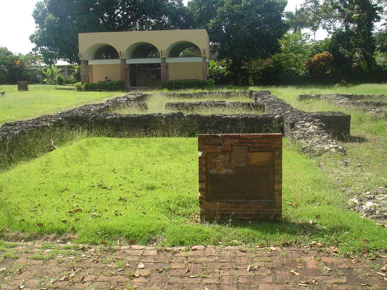
In 1508, Juan Ponce de León founded the original settlement which he called Caparra. It was named after the province of Cáceres in Spain, the birthplace of Nicolás de Ovando, then the Governor of Spain's Caribbean territories.[12] Today, it is part of the Pueblo Viejo district of Guaynabo, directly to the west of the modern municipality of San Juan. A year later, the settlement was moved to a site then called Puerto Rico, Spanish for "rich port" or "good port", after its similar geographical features to the town of Puerto Rico de Gran Canaria in the Canary Islands.[13]
The local Catholic diocese, the second oldest in the Americas and the oldest in the United States, was founded in the newly built settlement on August 8 of 1511.[14] In 1521, the newer settlement was given its formal name: Ciudad de Puerto Rico de San Juan Bautista. Many of the oldest European-founded institutions in the Western Hemisphere, such as the Santo Tomás de Aquino Convent and the Nuestra Señora de la Concepción Hospital, were established during this time in San Juan.[15]
The ambiguous use of San Juan Bautista and Puerto Rico for both the city and the island in time led to a reversal in practical use by most inhabitants: by 1746 the name for the city (Puerto Rico) had become that of the entire island, leading to the city being identified as Puerto Rico de Puerto Rico on maps of the era.[16][17][18]
Spanish Colonial era
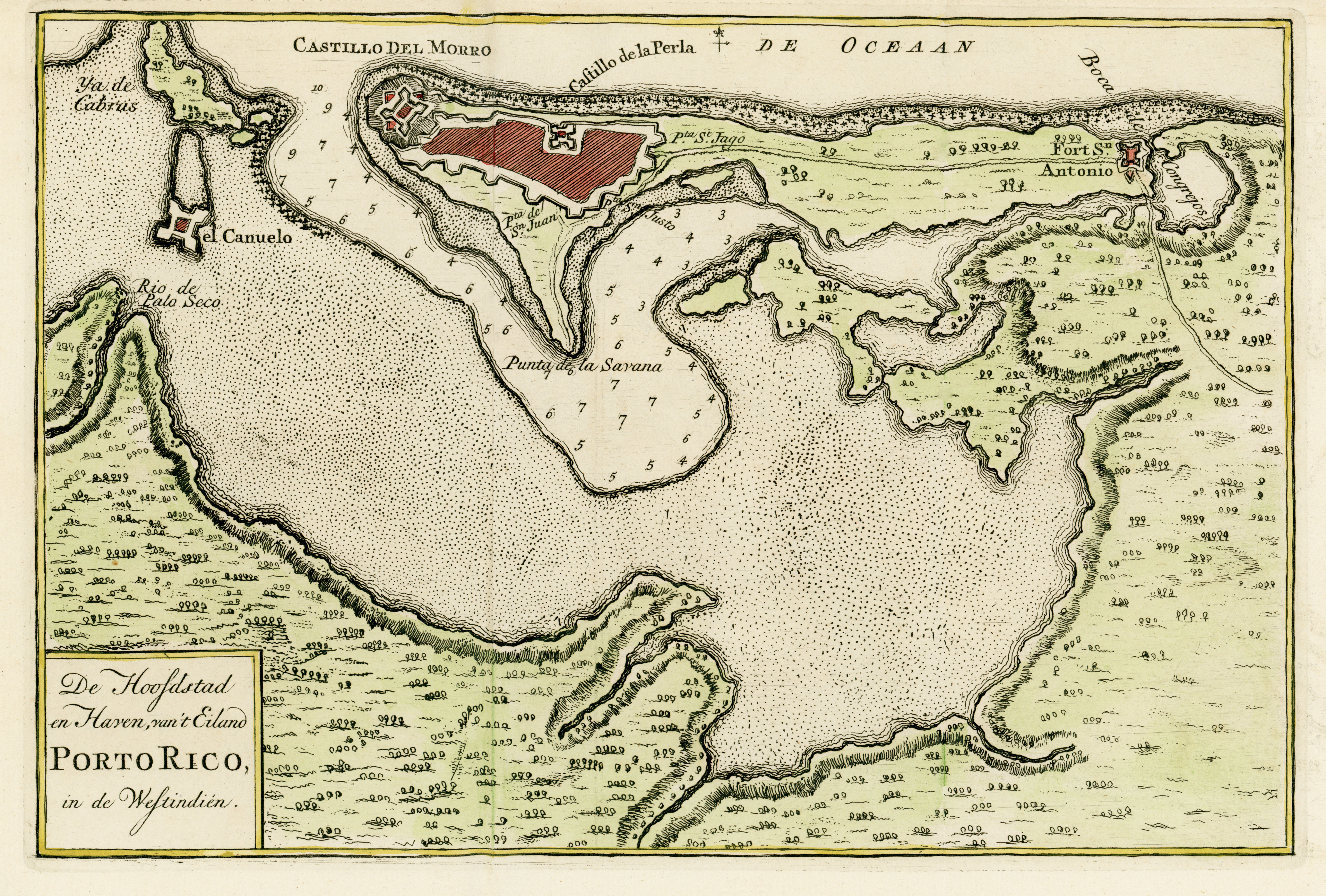
San Juan, as a settlement of the Spanish Empire, was used by merchant and military ships traveling from Spain as the first stopover in the Americas. Because of its prominence in the Caribbean, a network of fortifications was built to protect the transports of gold and silver from the New World to Europe. Because of the rich cargoes, San Juan became a target of the foreign powers of the time.[19]
San Juan underwent attacks from the English led by Sir Francis Drake in 1595 (in what is known as the Battle of Puerto Rico) and by George Clifford, Earl of Cumberland, in 1598. Artillery from San Juan's fort, El Morro, repelled Drake; however, Clifford managed to land troops and lay siege to the city.[20] After a few months of English occupation, Clifford was forced to abandon the siege when his troops began to suffer from exhaustion and sickness. In 1625 the city was sacked by Dutch forces led by Captain Balduino Enrico (also known as Boudewijn Hendricksz/Bowdoin Henrick), but El Morro withstood the assault and was not taken. The Dutch were counterattacked by Captain Juan de Amézqueta and 50 members of the civilian militia on land and by the cannons of the Spanish troops in El Morro castle. The land battle left 60 Dutch soldiers dead and Enrico with a sword wound to his neck which he received from the hands of Amézqueta.[21][unreliable source?]
The Dutch ships at sea were boarded by Puerto Ricans who defeated those aboard. After a long battle, the Spanish soldiers and volunteers of the city's militia were able to defend the city from the attack and save the island from an invasion. On October 21, Enrico set La Fortaleza and the city ablaze. Captains Amézqueta and Andrés Botello decided to put a stop to the destruction and led 200 men in an attack against the enemy's front and rear guard. They drove Enrico and his men from their trenches and into the ocean in their haste to reach their ships.[22]
The British attack in 1797, during the French Revolutionary Wars, led by Sir Ralph Abercromby (who had just conquered Trinidad). His army laid siege to the city but was forced to withdraw in defeat as the Puerto Rican defenses proved more resilient than those of Trinidad. Various events and circumstances, including liberalized commerce with Spain, the opening of the island to immigrants as a direct result of the Royal Decree of Graces of 1815, and the colonial revolutions, led to an expansion of San Juan and other Puerto Rican settlements in the late 18th and early 19th century.
Spanish-American War

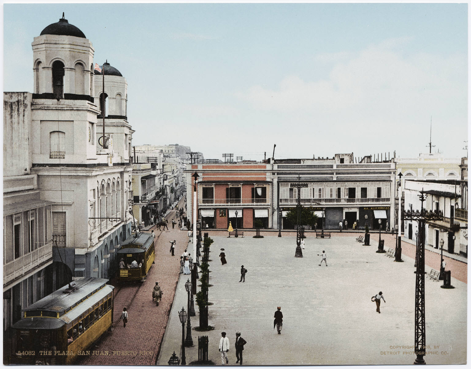
On May 8, 1898, United States Navy ships, among them USS Detroit, USS Indiana, USS New York, USS Amphitrite, USS Terror and USS Montgomery, commanded by Rear Admiral William T. Sampson arrived at San Juan Bay.[23][24] USS Yale captured the Spanish freighter Rita in San Juan Bay, thus being the first hostile encounter between the warring sides in Puerto Rico. On May 9, Yale fought a brief battle with an auxiliary cruiser of Spain, name unknown, resulting in a Spanish victory. Around this time, Captain Ángel Rivero Méndez was assigned the command of the Spanish forces in the fortress of San Cristóbal in San Juan. On May 10, Yale returned to San Juan Bay, Rivero-Méndez ordered his men to open fire upon Yale using an Ordoñez 15-centimeter cannon, thus becoming the first attack against the Americans in Puerto Rico during the Spanish–American War.[25]
For his actions, Captain Rivero-Méndez was awarded the "Cruz de la Orden de Mérito Militar" (The Cross of the Order of the Military Merit) first class.[25] The residents of San Juan were furious with Rivero and blamed him for the destruction caused to their city by the American bombardments. Nothing came of those accusations and Capt. Rivero-Méndez was ordered to turn over the keys of all the military installations in San Juan to Captain Henry A. Reed of the U.S. Army after the Treaty of Paris of 1898 was signed.[25]
On July 25, General Nelson A. Miles landed at Guánica (in southwestern Puerto Rico) with 3,300 soldiers in what was known as the Puerto Rican Campaign. The American troops found some resistance and engaged the Spanish and Puerto Rican troops in battle, the most notable of these the battles of Yauco and Asomante. All military actions in Puerto Rico were suspended August 13, 1898, after President William McKinley and French Ambassador Jules Cambon, acting on behalf of the Spanish government, signed an armistice.[26][27] Spain ceded the island to the United States later the same year by signing the Treaty of Paris.
20th-century
Camp Las Casas, located in the district of Santurce, served as the main training camp for the Puerto Rican soldiers prior to World War I and World War II; the majority of the men trained in this facility were assigned to the "Porto Rico Regiment of Infantry" which was renamed the 65th Infantry Regiment of the United States Army by the Reorganization Act of June 4, 1920. The 65th Infantry was deactivated in 1956 and became the only unit ever to be transferred from an active Army component to the Puerto Rico National Guard.[28]
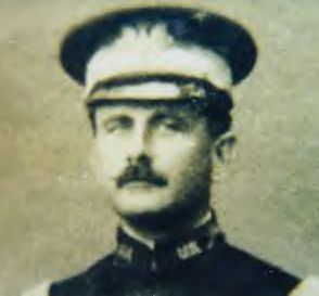
Lieutenant Teófilo Marxuach (retired as a Lieutenant Colonel), a native of Arroyo, Puerto Rico, fired the first shot in what is considered to be the first shot of World War I fired by the regular armed forces of the United States against any ship flying the colors of the Central Powers.[29] Marxuach, who was a member of the "Porto Rico Regiment of Infantry" and Officer of the Day, on March 25, 1915, opened fire on the Odenwald, an armed German supply vessel, when it was trying to force its way out of San Juan's bay.[30] The shots ordered by Lt. Marxuach were the first fired by the United States in World War I.[31]
In 1919, Félix Rigau Carrera, "El Aguila de Sabana Grande" (The Eagle from Sabana Grande), the first Puerto Rican pilot, became the first native Puerto Rican to fly an aircraft in the island when he flew his Curtiss JN-4 from Las Casas. At the time, the area was used by the military as an air base and it was also Puerto Rico's first commercial airport, and Rigau Carrera was allowed to perform his historic flight from the airfield.[32] Camp Las Casas was eventually closed down, and in 1950 a public housing project by the name of Residencial Fray Bartolome de Las Casas was constructed on its former location.
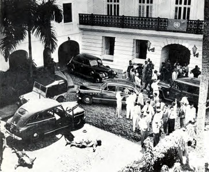
On January 2, 1947, the people of San Juan elected Felisa Rincón de Gautier (also known as Doña Fela) (1897–1994) as their mayor. Thus, she became the first woman to be elected as the mayor of a capital city in any of the Americas.[33] During the Cold War era, she ordered the establishment of the island's first Civil Defense system under the directorship of Colonel Gilberto José Marxuach (Teófilo's son).[34] Rincón de Gautier served as mayor until January 2, 1969. On October 30, 1950, San Juan was the scene of the San Juan Uprising, one of many uprisings which occurred in various towns and cities in Puerto Rico, by the Puerto Rican Nationalist Party against the governments of Puerto Rico and the United States. Among the uprising's main objective was to attack La Fortaleza and the United States Federal Court House Building in Old San Juan. The "La Fortaleza battle", which ensued between the nationalists and the police lasted 15 minutes and ended when four of the five attackers were killed.[35]
 A 17th-century Spanish painting commemorating Captain Juan de Amézqueta's victory and Enrico's defeat at Puerto Rico de San Juan; by Eugenio Caxés, Museo del Prado
 Castle San Felipe del Morro
 Rigau Carrera poses in his plane (1919)
 Lieutenant Teofilo Marxuach
 The bodies of two nationalists lie on the ground after their attack on La Fortaleza (1950)


Geography
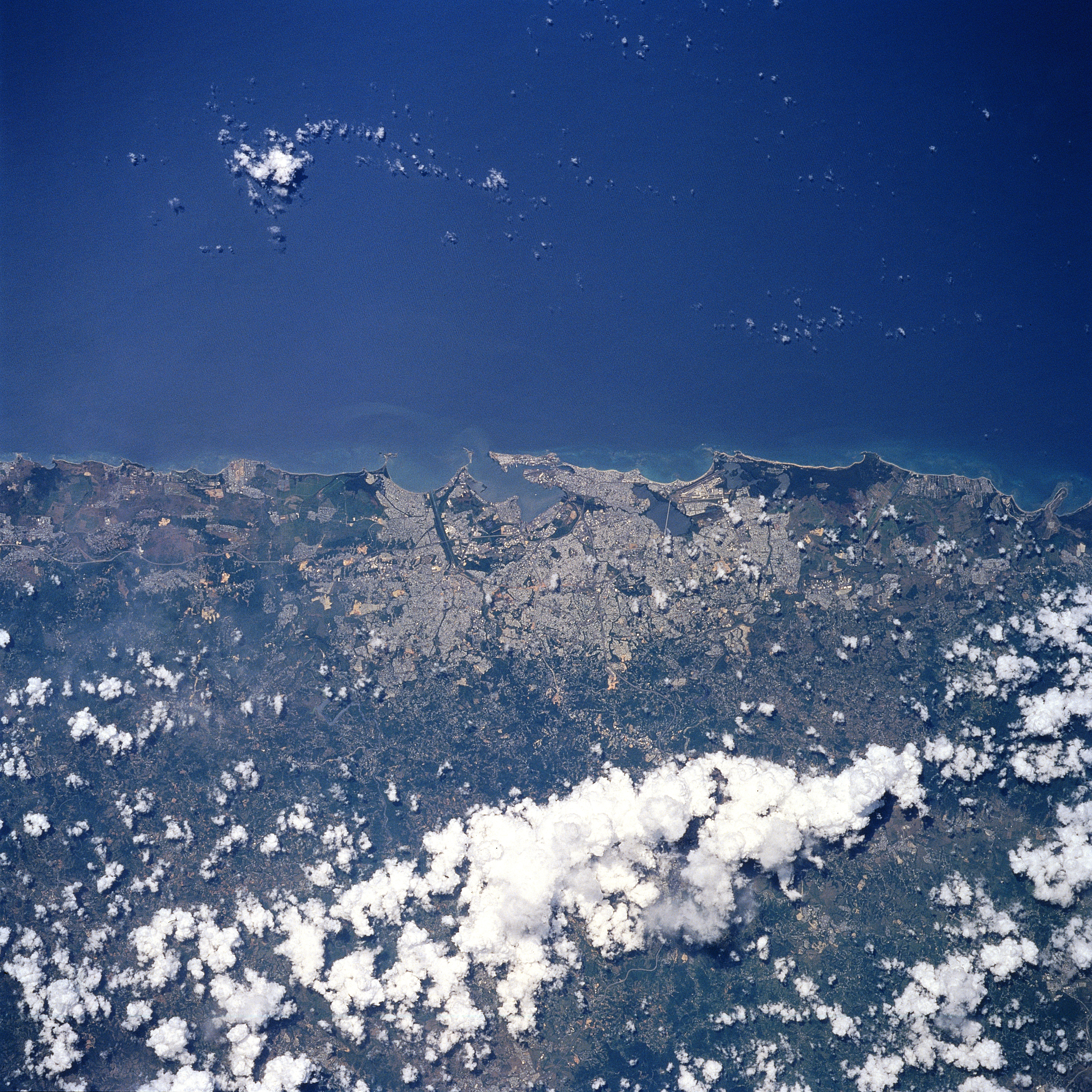
San Juan is located along the north-eastern coast of Puerto Rico in the Northern Plains region. It lies south of the Atlantic Ocean; north of Caguas and Trujillo Alto; east of Guaynabo; and west of Carolina. The city occupies an area of 76.93 square miles (199.2 km2), of which, 29.11 square miles (75.4 km2) (37.83%) is water. San Juan's main water bodies are San Juan Bay and two natural lagoons, the Condado and San José.[36] At almost 1,030 feet (314 m) above sea level, the highest point in the municipality of San Juan is located on an unnamed hill on the Morcelo sector of Caimito, close to the municipal border with Caguas.[37]
Climate
San Juan has a tropical monsoon climate (Am). It has an average temperature of 81.0 °F (27.2 °C). Temperatures of 90 °F (32 °C) or higher are seen on an average 79 days annually, more commonly occurring during the wetter months of the northern summer, especially if the winds come from the south.[38]
In the winter, temperatures can drop to around 60 °F (16 °C). The average winter low is 71 °F (22 °C). The coolest temperature officially recorded was 60 °F (16 °C) on March 3, 1957, and the hottest was 98 °F (37 °C) on October 9, 1981.[39] The record cold daily maximum is 71 °F (22 °C) on February 4, 1935. The record warm daily minimum is 83 °F (28 °C) on August 11, 1995, the most recent of four occasions.[38]
With a mean minimum of 67 °F (19 C), San Juan is in USDA plant hardiness zone 13B the highest category. Rainfall is well-distributed throughout the year. The months of January, February, and March are the driest. As March averages just 1.95 inches (49.5 mm) of rain, the city falls under the tropical monsoon category.[40]
Rainfall averages 56.35 inches (1,431.3 mm), falling on an average 198.5 days per year.[38] Despite this dampness, the city averages 2,970 hours of sunshine per year, or just over 2⁄3 of the possible total.[41] Annual rainfall has historically ranged from 35.53 in (902 mm) in 1991 to 89.50 in (2,273 mm) in 2010.[38]
Hurricane Maria
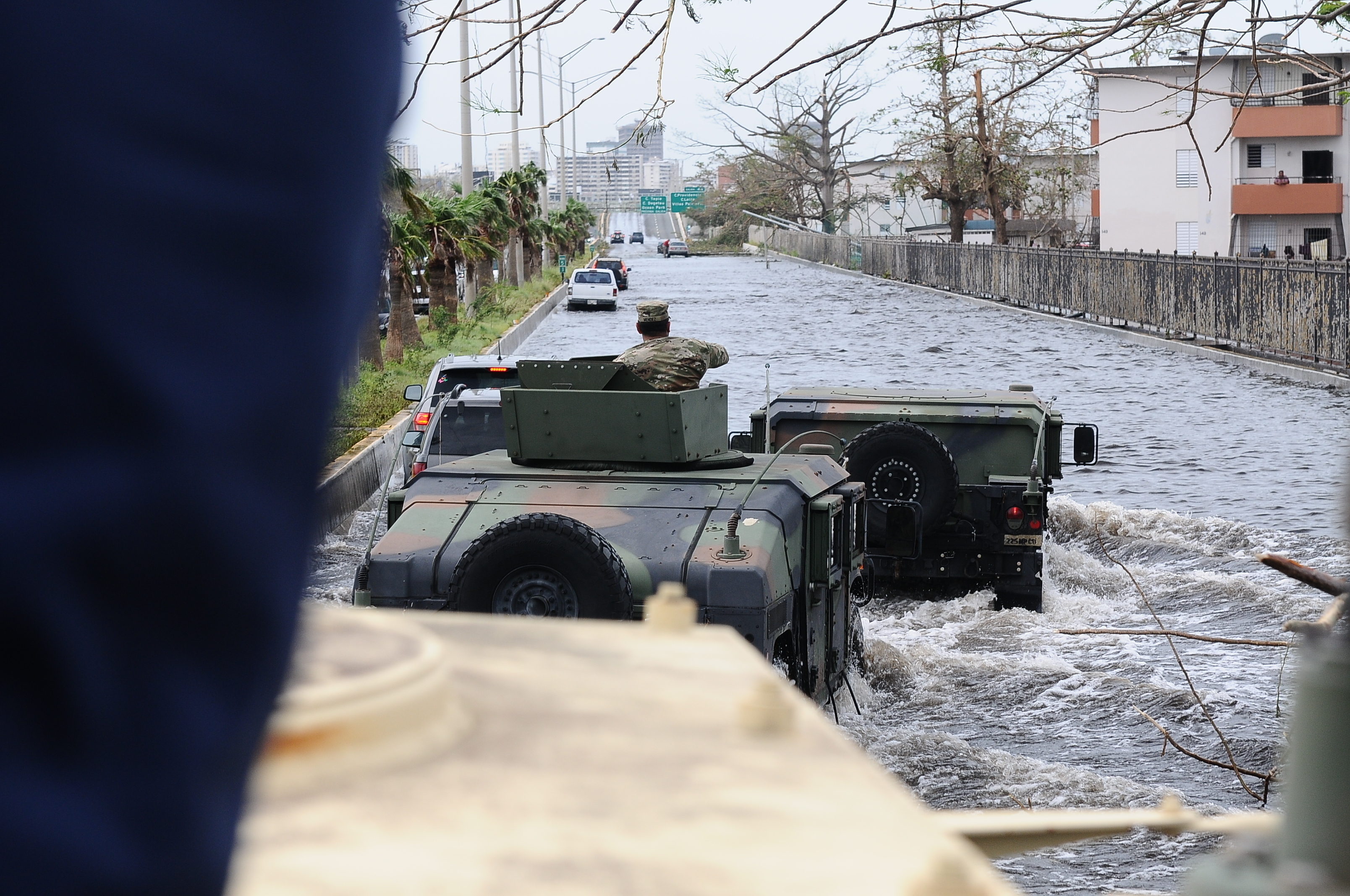
Much of San Juan was flooded with Hurricane Maria on September 20, 2017, which also triggered numerous landslides.[42][43]
| Month | Jan | Feb | Mar | Apr | May | Jun | Jul | Aug | Sep | Oct | Nov | Dec | Year |
|---|---|---|---|---|---|---|---|---|---|---|---|---|---|
| Record high °F (°C) | 92 (33) |
96 (36) |
96 (36) |
97 (36) |
96 (36) |
97 (36) |
95 (35) |
97 (36) |
97 (36) |
98 (37) |
96 (36) |
94 (34) |
98 (37) |
| Mean maximum °F (°C) | 87 (31) |
88 (31) |
90 (32) |
92 (33) |
92 (33) |
93 (34) |
92 (33) |
93 (34) |
94 (34) |
93 (34) |
90 (32) |
88 (31) |
94 (34) |
| Average high °F (°C) | 83.2 (28.4) |
83.8 (28.8) |
84.7 (29.3) |
86.2 (30.1) |
87.4 (30.8) |
89.0 (31.7) |
88.7 (31.5) |
89.1 (31.7) |
89.2 (31.8) |
88.6 (31.4) |
86.1 (30.1) |
84.2 (29.0) |
86.7 (30.4) |
| Daily mean °F (°C) | 77.6 (25.3) |
77.8 (25.4) |
78.6 (25.9) |
80.1 (26.7) |
81.6 (27.6) |
83.1 (28.4) |
83.1 (28.4) |
83.5 (28.6) |
83.4 (28.6) |
82.7 (28.2) |
80.5 (26.9) |
78.8 (26.0) |
80.9 (27.2) |
| Average low °F (°C) | 71.9 (22.2) |
71.8 (22.1) |
72.4 (22.4) |
74.0 (23.3) |
75.7 (24.3) |
77.2 (25.1) |
77.6 (25.3) |
77.8 (25.4) |
77.5 (25.3) |
76.7 (24.8) |
74.9 (23.8) |
73.3 (22.9) |
75.1 (23.9) |
| Mean minimum °F (°C) | 68 (20) |
69 (21) |
69 (21) |
71 (22) |
72 (22) |
74 (23) |
74 (23) |
74 (23) |
74 (23) |
74 (23) |
72 (22) |
70 (21) |
68 (20) |
| Record low °F (°C) | 61 (16) |
62 (17) |
60 (16) |
64 (18) |
66 (19) |
66 (19) |
69 (21) |
68 (20) |
69 (21) |
67 (19) |
65 (18) |
62 (17) |
60 (16) |
| Average rainfall inches (mm) | 4.07 (103) |
2.58 (66) |
2.18 (55) |
4.60 (117) |
5.54 (141) |
4.66 (118) |
6.02 (153) |
6.29 (160) |
6.50 (165) |
5.21 (132) |
7.37 (187) |
4.85 (123) |
59.87 (1,521) |
| Average rainy days (≥ 0.01 in) | 18.4 | 15.3 | 13.1 | 14.3 | 16.5 | 15.1 | 19.0 | 19.8 | 18.3 | 17.7 | 20.6 | 20.2 | 208.3 |
| Average relative humidity (%) | 74.0 | 72.4 | 71.0 | 71.3 | 74.9 | 75.5 | 75.9 | 76.4 | 76.4 | 76.9 | 76.2 | 74.7 | 74.6 |
| Mean monthly sunshine hours | 237.4 | 231.2 | 282.0 | 268.3 | 255.2 | 259.4 | 280.8 | 267.8 | 234.7 | 227.2 | 202.4 | 217.4 | 2,963.8 |
| Percent possible sunshine | 69 | 72 | 76 | 71 | 63 | 65 | 69 | 68 | 64 | 63 | 60 | 64 | 67 |
| Average ultraviolet index | 8 | 10 | 12 | 12 | 12 | 12 | 12 | 12 | 12 | 10 | 9 | 8 | 11 |
| Source 1: NOAA (relative humidity and sun 1961–1990)[38][45][41] | |||||||||||||
| Source 2: The Weather Channel[39], Weather Atlas (UV)[46] | |||||||||||||
Beaches

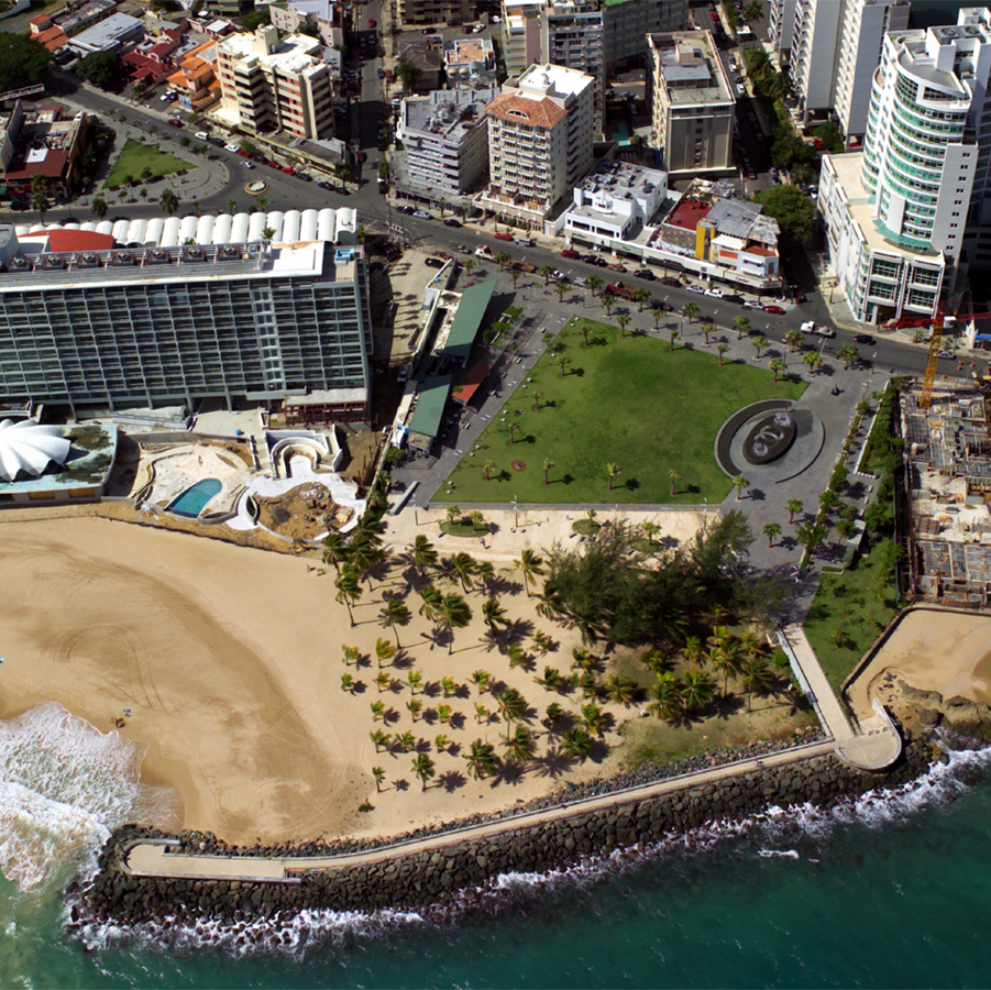
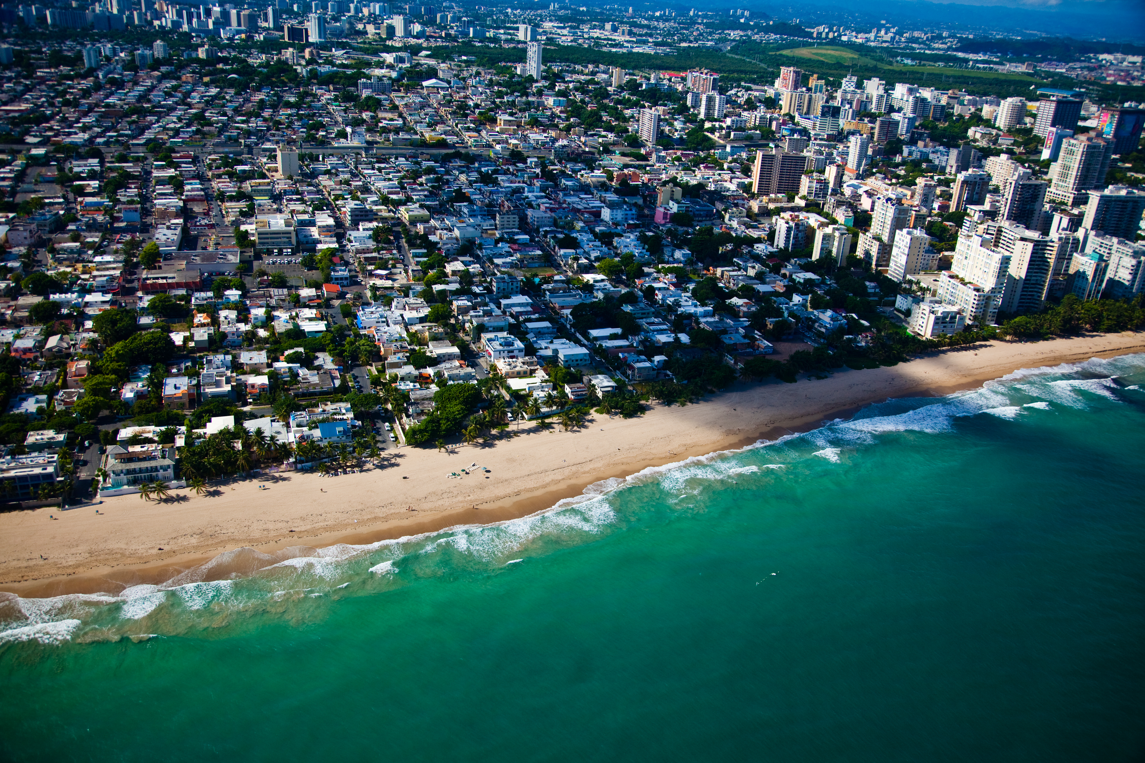
San Juan is home to numerous beaches, all of which are open to the public.[47] All beaches of San Juan face the Atlantic Ocean. The Islet of San Juan hosts Los Cables Beach and La Perla Beach next to the Old San Juan district of La Perla, the Capitolio Beach located immediately north of the Puerto Rico Capitol, Puerta de Tierra Beach along the Paseo de Puerta de Tierra, and El Escambrón Beach at the northeastern edge of the islet. The latter is the most popular beach in the islet due to its shore being protected from the strong Atlantic Ocean waves by reefs that serve as natural breakwaters.[48] From east to west, the beaches in Santurce include Ocean Park Beach (also known as Último Trolley Beach), Condado Beach and Playita del Condado. Ocean Park Beach and El Condado Beach are the largest in the city and they host a large number of hotels and businesses that cater to tourists and beachgoers.[49][50]
Parks
The municipality of San Juan contains numerous parks, including public parks, historic and heritage parks, nature reserves, protected natural areas, and recreational parks. These parks are managed by a number of entities such as the Municipality, the Puerto Rico Department of Natural and Environmental Resources, the National Park Service, the University of Puerto Rico and conservation easements.
San Juan Ecological Corridor

The San Juan Ecological Corridor is a conservation project by the Government of Puerto Rico consisting in 6 different units found within the municipality of San Juan: the Cupey Arboretum, which protects the riparian ecosystems along the Río Piedras; the Doña Inés Mendoza Urban Forest, a small urban forest located next to the Luis Muñoz Marín Foundation in Sabana Llana Sur; Los Capuchinos Forest, a forest which covers a small karst area also in Sabana Llana Sur; the New Millennium State Forest, one of the 20 state forests of Puerto Rico; the San Juan Waterworks, consisting of the Old Piedras River Aqueduct and adjacent historic district; and the University of Puerto Rico Botanical Garden, also known as the San Juan Botanical Garden.[51]
Historic parks
The San Juan National Historic Site is home to El Morro Esplanade, a large open area located between El Morro and Ballajá in Old San Juan. The esplanade is located in the promontory which gives El Morro its name and it offers views of the San Juan Bay and the rest of San Juan. It is very popular for activities such as picnics, stargazing[52] and kite flying.[53]
The district of the Capitol of Puerto Rico is home to the Iglesias Pantín and Rafael Hernández Marín parks, and a line of monuments located along Constitución Avenue which includes the Walkway of the Presidents, the Puerto Rico Police Memorial Monument and The Holocaust Memorial Monument. The Loma de los Vientos, or Loma del Viento (Spanish for "hill of winds"), is a small open green area located northwest of the Capitol, next to Castle San Cristóbal, and it often hosts events such as the Epiphany celebrations.[54]
Luis Muñoz Rivera Park is a 27.2 acre recreational and historic park located in Puerta de Tierra, between Luis Muñoz Rivera, Ponce de León and Constitución avenues. It is the largest public square in Puerto Rico, and it is home to several historic sites such as the Polvorín San Gerónimo de Boquerón, which used to supply gunpowder to the nearby Fortín de San Gerónimo. The park used to host a small zoo, and currently hosts gazebos, gardens, restaurants and access to the beach. The park has been listed on the National Register of Historic Places since November 14, 2007.[55]
The Polvorin de Miraflores is a historic district and park located next to the Puerto Rico Convention Center in Isla Grande, Santurce. The ammunition storage house dates to the mid-18th century and it is also listed on the National Register of Historic Places.[56]
Another historic district currently under revitalization is the San Juan Waterworks historic district which contains the Old Piedras River Aqueduct. There are plans to revitalize the old aqueduct structures and its surroundings to create a historic park open to visitors and researchers.[57]

Municipal parks
Some of the recreational parks of the municipality include Bahía Urbana, a waterfront park located in Old San Juan and Puerta de Tierra by the San Juan Bay; the Paseo de Puerta de Tierra, a recreational walkway along the Atlantic Ocean cliffs of Puerta de Tierra that connects the Puerto Rico Capitol with El Escambrón Beach and Luis Muñoz Rivera Park.
Ventana al Mar, Laguna del Condado Jaime Benítez Park, Parque del Indio are some of the parks located in El Condado district of Santurce. Dr. José Celso Barbosa Park is located in Ocean Park, also in Santurce. Parque Central, also known as the San Juan Municipal Central Park, is a large park and recreational complex located in southern Santurce near the mouth of the Puerto Nuevo River and the Martín Peña Channel. The Enrique Martí Coll Linear Park connects the Central Park to Hato Rey through the Caño Martín Peña Nature Reserve.[58]
Luis Muñoz Marín Park, La Merced Park, Dr. José N. Gándara Park, Santiago Iglesias Pantín Park are some of the parks located in Hato Rey.[59] Luis Muñoz Marín Park is one of the largest in the municipality. It is located in the Gobernador Piñero district between Hato Rey and Puerto Nuevo. The park has gazebos that can be rented for events, green areas for strolls, biking and picnics, an artificial lake with paddleboats for rent ($6), and a number of playgrounds for children. Its main attraction is the cableway that crosses the park and offers scenic views of the Piedras River and the city while providing transportation to the Roberto Clemente Coliseum and the Hiram Bithorn Stadium.[60]
Nature reserves
The municipality of San Juan is home to various important ecosystems and preserved natural areas. Some of the ecosystems of the San Juan Bay National Estuary, which is the only tropical estuary in the National Estuary Program network, are protected by numerous nature reserves and protected areas such as the Caño Martín Peña Nature Reserve. Other areas protected under the San Juan Bay National Estuary include El Condado Lagoon, the San José Lagoon and El Boquerón where the San Antonio Creek and the Condado Lagoon connect with the Atlantic Ocean.[61]
Two of the 20 state forests of Puerto Rico are located in the municipality of San Juan: the New Millennium Urban Forest, which is also part of the San Juan Ecological Corridor, and the San Patricio Urban Forest, a secondary forest located next to a mogote. The Hermanas Sendra and San Juan Park Protected Natural Areas are located inland within the municipality of San Juan in the barrios of Caimito and Cupey.[62]
Cityscape

Architecture
The architecture of San Juan is very diverse, due to its size and all the cultural influences received during its existence. The oldest part of the city, known as Old San Juan, mostly features the influence of Spanish architecture. This part of the city is comprised by a network of "setted" roads usually surrounded by ancient, two-storied houses built on masonry. Some colonial structures have been restored and serve either as government offices or museums.[63]
Some examples are the Ballajá Barracks, which now serve as museum and headquarters of several cultural organizations; La Fortaleza, which has served as the residence of the Governor of Puerto Rico since the 16th Century; and the Ancient Welfare Asylum, which now houses the Institute of Puerto Rican Culture, among others. Old San Juan also features several public squares, like the Plaza de Armas, located in front of San Juan City Hall; and cathedrals, like the Cathedral of San Juan Bautista.[63] Old San Juan is also notable for being partly enclosed by massive walls and fortifications built by the Spanish government.
The architecture is more varied in other districts of the city. The district of Santurce features a lot of influence from Art Deco, while the districts of Hato Rey feature more modern structures.[citation needed]
Barrios
What is now known as Old San Juan occupied the western end of a rocky islet, the Isleta de San Juan, at the mouth of San Juan Bay. During the 20th century, the main population centers surged well beyond the walls of the old city and onto Puerto Rico's main island and merged with the existing settlements east and south of Old San Juan.
With the annexation of Río Piedras in 1951, the municipality of San Juan grew to four times its previous size. As a result, the municipality also went from 2 to 18 barrios (barrios),[64] 16 of which fall within the former municipality of Río Piedras. Eight of the 18 barrios are further subdivided into subbarrios, including the two barrios (San Juan Antiguo and Santurce) that belonged to the original municipality of San Juan. The 18 barrios are:
- Caimito
- Cupey
- El Cinco
- Gobernador Piñero
- Hato Rey Central
- Hato Rey Norte
- Hato Rey Sur
- Monacillo
- Monacillo Urbano
- Oriente
- Pueblo
- Quebrada Arenas
- Sabana Llana Norte
- Sabana Llana Sur
- San Juan Antiguo (not to be confused with Old San Juan, a historic district with some overlapping areas)
- Santurce
- Tortugo
- Universidad
Old San Juan
During the Spanish colonial times most of the urban population resided in what is now known as Old San Juan. This sector is located on the western half of a small island called the Isleta de San Juan, which is connected to the mainland by two bridges and a causeway. The small island, which comprises an area of 47 square miles (120 km2), also hosts the working-class neighborhood of Puerta de Tierra and most of Puerto Rico's central government buildings, including the Commonwealth's Capitol.[citation needed]
The main central part of the city is characterized by narrow streets made of blue cobblestone and picturesque colonial buildings, some of which date back to the 16th and 17th century. Sections of the old city are surrounded by massive walls and several defensive structures and notable forts. These include the 16th-century Fort San Felipe del Morro and the 17th-century Fort San Cristóbal, both part of San Juan National Historic Site, and the 16th-century El Palacio de Santa Catalina, also known as La Fortaleza, which serves as the governor's mansion.[65]
Other buildings of interest predating the 20th century are the Ayuntamiento or Alcaldía (San Juan City Hall), the Diputación Provincial and the Real Intendencia buildings, which house the Puerto Rico Department of State,[66] the Casa Rosa, the San José Church (1523) and the adjacent Hotel El Convento, the former house of the Ponce de León family known as Casa Blanca, the Teatro Tapia, the former Spanish barracks (now Museum of Ballajá), La Princesa (former municipal jail, now headquartering the Puerto Rico Tourism Company), and the Santa María Magdalena de Pazzis Cemetery, located just outside the city walls.[67][68][69]
The Cathedral of San Juan Bautista (construction began in the 1520s) is also located in Old San Juan and contains the tomb of the Spanish explorer and settlement founder Juan Ponce de León.[70] Old San Juan, also known as the "old city", is the main cultural tourist attraction in Puerto Rico; its bayside is lined by dock slips for large cruise ships.
Other districts
East of Old San Juan lies the wealthy tourist-oriented neighborhood of Condado, which occupies land that used to be owned by entrepreneur Pablo Ubarri Capetillo, a Spanish railroad developer and Count of San José de Santurce under the Spanish colonial period. Beaches such as nearby Ocean Park, popular with swimmers, surfers and kitesurfers, are found all along the district's Atlantic coastline which is also the locus of numerous hotels.[71]

Near Condado are two separate business districts, Santurce and Miramar. Miramar is mainly a residential area rising south of the Condado Lagoon. It comprises the former barrio of Miraflores, as well as drained marshland and landfill over which was built San Juan's first airport, the Isla Grande airport, which was renamed Fernando Luis Ribas Dominicci Airport in honor of Major Fernando Luis Ribas-Dominicci (USAF). Miramar now hosts the Puerto Rico Convention Center as well as some of San Juan Harbor's cruise ship piers. In 2005 Miramar was designated an historical district of Puerto Rico.[72]
Santurce, originally named San Mateo de Cangrejos (Saint Matthew of the Crabs), was a settlement for freed African slaves during the early days of the city. After Pablo Ubarri sought permission to link San Juan with Río Piedras proper via steam tramway in 1878, the time it took to travel between both points were shortened and thereby stimulated the colonization and growth of the district. At the beginning of the twentieth century an electric trolley was installed, the township was split into three parts, and its main settlement, merged with the city, was renamed using the Spanish spelling of Santurtzi (Saint George in Basque), Ubarri's birthplace in Vizcaya, Spain. The "Museo de Arte de Puerto Rico" (Puerto Rico Museum of Art)[73] and other important cultural venues are located in Santurce.

South of Santurce is Hato Rey, part of the former municipality of Río Piedras. Hato Rey was grazing ground for cattle owned by the royal government (hence its name, the King's Herd in Spanish) as early as the 16th century,[74] and is now considered the financial center of the island. A section of this district is often referred to as Milla de Oro (actually 0.47 miles or 0.76 kilometers long) due in part to the many banks and businesses located there.[74]
In the southern part of the city is the socially diversified community of Río Piedras. Founded in the mid-1850s, Río Piedras was a separate town which hosted sugar cane plantations and the estates of some of San Juan's wealthiest inhabitants (as well as their working-class staff). The Spanish colonial governors also had their summer home there on land which eventually gave way to the main campus of the University of Puerto Rico. In 1951 the municipalities of San Juan and Río Piedras were merged to redefine San Juan's current city limits. Today Río Piedras comprises the largest area of the municipality of San Juan.[75] and is home to the "Plaza del Mercado" (Río Piedras Marketplace), the main campus and the Medical Sciences campus of the University of Puerto Rico and the San Juan Botanical Garden.
Demographics
| Race | Population | % of Total |
|---|---|---|
| White | 268,708 | 68.0% |
| Black/African American | 73,538 | 18.4% |
| American Indian and Alaska Native | 3,071 | 0.8% |
| Asian | 1,750 | 0.4% |
| Native Hawaiians/Pacific Islander | 36 | 0.0% |
| Some other race | 32,386 | 8.2% |
| Two or more races | 15,835 | 4.0% |
| Year | Pop. | ±% |
|---|---|---|
| 1899 | 32,048 | — |
| 1910 | 48,716 | +52.0% |
| 1920 | 69,733 | +43.1% |
| 1930 | 114,715 | +64.5% |
| 1940 | 169,247 | +47.5% |
| 1950 | 224,767 | +32.8% |
| 1960 | 451,658 | +100.9% |
| 1970 | 463,242 | +2.6% |
| 1980 | 434,849 | −6.1% |
| 1990 | 437,745 | +0.7% |
| 2000 | 434,374 | −0.8% |
| Source: Census[77] | ||
| Year | Pop. | ±% |
|---|---|---|
| 1899 | 13,760 | — |
| 1910 | 18,880 | +37.2% |
| 1920 | 24,745 | +31.1% |
| 1930 | 40,853 | +65.1% |
| 1940 | 68,290 | +67.2% |
| 1950 | 134,989 | +97.7% |
| 2000 | 332,344 | +146.2% |
San Juan is the largest city in Puerto Rico by population.[78] From 1899 to 1950 the municipality of San Juan excluded the township of Río Piedras. For this reason, population data and land area for the period make reference only to the Antiguo San Juan and Santurce barrios, or subdivisions, of San Juan. The old municipality of Río Piedras constituted the third most populated city of Puerto Rico at the time of its annexation in 1951. Its strategic location south of the capital served as a junction for all the principal ways of transportation of the island and as a geographical entry to San Juan, which are factors that prompted Río Piedras's dramatic urban development in the 20th century.[citation needed]
According to the 2010 Census, the racial composition of San Juan was as follows:
- White: 68.0% (Non-Hispanic Whites: 1.2%)
- Black or African American: 18.3% (Non-Hispanic Blacks: 0.3%)
- American Indian: 0.8%
- Asian: 0.4%
- Native Hawaiian/Pacific Islander: 0.0%
- Some other race: 8.2%
- Two or more races: 4.0%
- Hispanic or Latino (of any race): 98.2%
Among the Hispanic and Latino population, Puerto Ricans are the largest group; they make up 87.5% of San Juan's Hispanic population. People of Dominican descent make up 7.6% of the Hispanic population, while those of Cuban descent form 1.7% of the Hispanic populace. Other Hispanic and Latino groups collectively form 3.2% of San Juan's Hispanic population.
There are 4,822 whites and 1,187 blacks of non-Hispanic origin living in San Juan. Non-Hispanic whites and blacks form 1.2% and 0.3% of San Juan's population respectively. There are also approximately 673 Asians of non-Hispanic origin in San Juan; they make up less than 0.1% of the population. However, Asians of Hispanic and non-Hispanic origin together number at 6,342.[79]
The vast majority of Asians in San Juan are of Chinese descent; of the 6,342 Asians, 4,928 are Chinese. Chinese comprise 1.4% of the population. The only other sizable Asian group in San Juan are Indian Americans; there are 698 people of Indian descent in the city, forming 0.2% of the population. There are very small numbers of people of Filipino, Japanese, and Vietnamese ancestry; none of these groups number more than 100 members.[79]
According to the 2006–2008 American Community Survey, 87.5% of San Juan's population was native and 12.5% were foreign-born. Of the native population, 86.9% were born in Puerto Rico or the U.S. proper, of which 75.6% were born in Puerto Rico and 8.9% were born in the U.S. The other 0.7% were born in a different U.S. territory or born abroad to American parents. The remaining 11.9% of the population were born outside the United States and U.S. territories.
In recent years, an increasing number of Americans not of Hispanic ancestry (both of African American and of White American descent) have moved to San Juan. In addition, a large number of Stateside Puerto Ricans have settled in the city upon their return to Puerto Rico. There is also a growing West Indian population, both of Hispanic and non-Hispanic origin.
In terms of ancestry, 23,875 people claimed American ancestry, which is equivalent to 5.8% of San Juan's population. Other sizable ancestry groups included those of Italian descent, French descent, and West Indian descent. People of Italian descent numbered at 1,694, forming 0.4% of the population; people of French descent numbered at 1,064, forming 0.2% of the population. Finally, those of West Indian descent numbered at 1,393, forming 0.3% of San Juan's population. Approximately 1,026 people claimed Sub-Saharan African ancestry; 719 claimed Irish ancestry; 646 claimed German ancestry; 431 claimed Arab ancestry, and 346 claimed English ancestry. There are many other ancestry groups in San Juan, but they are very scant.[80]
Economy
San Juan experienced significant economic growth following World War II. During this period the city underwent an industrial revolution, although as of 1984 it had never generated its own economic region.[81][82] The city's economy relies mostly on companies dedicated to the manufacture of several products, including: Chemical substances (bleach and house cleaning products); medicines; rum and other beverages; fertilizers; electric tools; electronic devices; plastics, textiles, and food-based products.[82]
Tourism is also a key industry, based on San Juan's proximity to Puerto Rico's main airport, the Luis Muñoz Marín International Airport.[82] The tourism focus of the city is located in the district of Condado Beach where there are luxurious hotels.[82] Historical locations such as El Morro, Old San Juan and El Cuartel de Ballaja are promoted in tourism campaigns. The district of Hato Rey contains a corporate sector known as "La Milla de Oro", (The Golden Mile) which serves as the headquarters of local and international banks. San Juan's Hato Rey district is often referred to as the "Wall Street of the Caribbean", due to the influence of the area on Puerto Rico and the Caribbean's economy.[74]
Seaborne Airlines is headquartered on the ninth floor of the World Plaza Building in San Juan.[83]
Tourism

Technological advances after World War II in the development of the airliner, coupled with the island's climate and natural setting, have transformed San Juan into the springboard for tourism around the island, and has made the rest of the Caribbean known throughout the world during the last fifty years.[84] Today the capital features hotels, museums, historical buildings, restaurants, beaches and shopping centers. In San Juan there are tourist attractions, including: Old San Juan, Ocean Park, Isla Verde and Condado.
Places and monuments emphasized in tourism campaigns include: Old San Juan, promoting the historic nature of its colonial buildings and narrow streets covered by cobblestones, a blue stone cast from furnace slag; they were brought over as ballast on Spanish ships.[82] This includes the city's ancient defensive wall and forts, most notably El Morro and the Castillo San Cristóbal.[82] On January 23, 1984, both of these edifices were catalogued as being part of humanity's cultural patrimony.[82] The restaurants and art galleries in the zone are visited by tourists.[82] The local universities are promoted as historic places, most notably the campus of University of Puerto Rico located in Río Piedras, which is the oldest university on the island being founded in 1903.
Post Hurricane Maria
An April 2019 report indicated that, by that time, repairs after Hurricane Maria were moving rapidly. Only a few hotels were still closed in San Juan and that life for tourists in and around the capital had, for the most part, returned to normal.[85] By October 2019, nearly all of the popular amenities for tourists, in the major destinations such as San Juan, Ponce and Arecibo, were in operation on the island and tourism was rebounding. This was important for the economy, since tourism provides up 10% of Puerto Rico's GDP, according to Discover Puerto Rico.[86]
In late November 2019, reports indicated that 90 calls to San Juan by Royal Caribbean ships would be cancelled during 2020 and 2021. This step would mean 360,000 fewer visitors, with a loss to the island's economy of $44 million. As well, 30 ship departures from San Juan were being canceled. The rationale for this decision was discussed in a news report, as follows:[87]
The reason for the cancellations is the privatization of the cruise docks in San Juan due to much-needed maintenance that is needed. Around $250 million investment is needed to make sure cruise ships can continue to dock there in the years to come. There is an urge for governor Wanda Vazquez to not go ahead with the privatization so this news is fluid.[needs update]
Arts and culture

San Juan is the birthplace of artists and musicians who have significantly influenced Puerto Rican culture. During the 20th century, the musical aspect of the city was influenced by performers including Afro-Caribbean dancer and choreographer Sylvia del Villard and José Enrique Pedreira who became a composer of Puerto Rican Danzas. International musicians such as opera singer Justino Díaz and Grammy Award winners Ramón Ayala (Daddy Yankee) and Ricky Martin were born in the city. Other notable residents include writers Giannina Braschi and Tomas Blanco, award-winning actors Raul Julia and Benicio del Toro, and comedian José Miguel Agrelot. Rafael Cordero (1790–1868), was influential in the development of Puerto Rican education and has been once renowned[by whom?] as "The Father of Public Education in Puerto Rico".
Performing arts
The Luis A. Ferré Performing Arts Center (Spanish: Centro de Bellas Artes Luis A. Ferré) hosts some of the most important musical and artistic events in Puerto Rico. It is home to the Puerto Rico Symphony Orchestra (PRSO) and hosts the Casals Festival, the most important classical music festival in the Caribbean. The venue also hosts theater and musical performances such as Hamilton, which it hosted in 2019.[88] The Conservatory of Music of Puerto Rico is a public music conservatory that hosts Puerto Rican and international students has a longstanding relationship with the classical music movement in the island. The Ateneo Puertorriqueño and the theater of the University of Puerto Rico, Rio Piedras also host important music events.
Museums

The city is also the home of contemporary and classic art museums. The Puerto Rico Museum of Art hosts the largest collection of contemporary art in Puerto Rico, housing over 1,100 permanent art pieces and displaying temporary exhibitions containing artwork from various locations through Latin America.[89] The Puerto Rico Museum of Contemporary Art, located in Santurce, specializes in contemporary artwork from Latin America and the Caribbean. The paintings displayed in the permanent exhibition are either acquired by the museum's administrative personnel or donated by artists and collectors. They are judged by a panel of painters, art critics, and scholars before being displayed.[90]
Other museums such as the Pablo Casals Museum, the San Juan Book Museum, the Museum of the Americas, and the National Gallery display historic items and artwork alongside contemporary art.[91][92] Miscellaneous museums such as the Children's Museum and the Bacardi Distillery (also known as the "Rum Cathedral") in nearby Cataño appeal to different audiences through interactive exhibitions.[93][94]
Old San Juan is also home to important art museums, such as the Puerto Rico National Gallery, and numerous private art galleries.
Government
Structure

As one of Puerto Rico's 78 municipalities, San Juan's government consists of two branches, the executive and the legislative. Those citizens eligible to vote directly elect the Mayor of San Juan and the municipal assembly for four-year terms. The municipal government is housed in City Hall or Casa Alcaldia, which is located at 153 San Francisco Street, facing the Plaza de Armas at the center of Old San Juan.[95] City Hall was constructed based on Madrid's City Hall starting in 1604 and finally completed in 1789.[95]
The executive branch is headed by a popularly elected mayor. The office is held by Miguel Romero Lugo who won in the 2020 general election.[96] Miguel Romero Lugo took over from Carmen Yulín Cruz, who was elected at the 2012 general election. Before her, Jorge A. Santini held the position for 12 years. In addition to running the city's day-to-day operations and supervising associated departments, the mayor is responsible for appointing a secretary-auditor and a treasurer. San Juan's Municipal Legislature is made up of 17 municipal legislators, elected at-large, which represent the city's population.[97]
Coat of arms and flag

The municipio has an official flag and coat of arms.[98]
On March 8, 1948, the city government of San Juan officially adopted as the city's first flag an orange field, in the center of which is the coat of arms of the city. The orange color was based and taken from Father Diego de Torres Vargas' text and it reads:
"Escudo de armas dado a Puerto Rico por los Reyes Católicos en el año de 1511, siendo Procurador un vecino llamado Pedro Moreno. Son : un cordero blanco con su banderilla colorada, sobre un libro, y todo sobre una isla verde, que es la de Puerto Rico, y por los lados una F y una I, que quiere decir Fernando e Isabel, los Reyes Católicos que se las dieron, y hoy se conservan en el estandarte real, que es de damasco anaranjado, con que se ganó la ciudad".[99]
("Coat of arms given to Puerto Rico by the Catholic Monarchs in the year 1511 being Procurator a vecino (citizen) named Pedro Moreno. They are a white lamb with a red flag, on top of a book, and everything above a green island, which is Puerto Rico...which is of orange damask, with which the city was won"). It appears that the color was changed from orange to white at some point.[100][99]
Territorial and federal government
San Juan is the territorial capital of the Commonwealth of Puerto Rico, and it is home to the executive, legislative and judicial branches of the Puerto Rican government. San Juan is also the seat of the Puerto Rico Senatorial district I, which is represented by two Senators.[101] The United States District Court for the District of Puerto Rico is located in Hato Rey.
Safety
In 2010 there were 201 homicides in San Juan, a rate of around 50 per 100,000 residents. In 2019 they were 172 homicides a rate of 53 per 100,000 residents.[102] Law enforcement in San Juan is the joint responsibility of the Department of Police and Public Safety, also known as the San Juan Police Department and the Puerto Rico Police Department.[103] The Municipal Police, originally known as the "San Juan Municipal Guard", was created in 1521 and had active military and law enforcement functions until 1980, when Act #77 created municipal law enforcement agencies in Puerto Rico. It employs over 1,000 sworn officers plus civilian staff.[104]
Media
Newspapers
Most of Puerto Rico's major newspapers are published in San Juan: El Nuevo Día, Primera Hora, El Vocero and the English-language San Juan Star.[105][106] Other newspapers published in San Juan are Metro Puerto Rico, Indice and Caribbean Business News.[107]
Radio
San Juan is also home to several of Puerto Rico's major radio stations: WKAQ 580 AM and 105 FM, WPRM Salsoul 99.1 FM, WODA La Nueva 94 FM, Fidelity 95.7 FM, WSKN Radio Isla 1320 AM, WORO Radio Oro 92.5 FM, Salsa Hits Radio, WAPA Radio, WOYE Magic 97.3, WRTU Radio Universidad FM, WIPR 940 AM, Mix 107.7 FM, WTOK Hot 102, AZ Rock, Radio Antillas, etc.[108]
Television
Some of the television states based in San Juan are WKAQ-TV Telemundo/NBC Puerto Rico, WORA Univision Puerto Rico, WAPA-TV, WIPR-TV, WTCV Mega TV, WJPX América TeVé, etc.[109]
Movies and filming
San Juan has been the setting of numerous movies and the city has also been used as a stand-in or substitute for other cities and countries where filming is more expensive, more dangerous or more restrictive. Some of the most popular movies filmed in San Juan are: Woody Allen's Bananas (1971), Captain Ron (1992), Assassins (1995), Amistad (1997), Bad Boys II (2003) standing-in as Havana, Dirty Dancing: Havana Nights (2004) also as Havana, The Men Who Stare at Goats (2009) standing-in as Iraq, The Losers (2010), Fast Five (2011) stading-in as Miami and Rio de Janeiro, Pirates of the Caribbean: On Stranger Tides (2011) standing-in as Cádiz, Spain, The Rum Diary (2011), 22 Jump Street (2014) standing-in as a Mexican resort, Captain America: Civil War (2016) standing-in as Lagos, Nigeria, and the controversial film Force of Nature (2020).[110][111]
Education
Colleges and universities

San Juan is home to many of Puerto Rico's institutions of higher learning. The University of Puerto Rico Río Piedras Campus is located in San Juan, along with the University of Puerto Rico's Medical Sciences Campus. Other colleges located in San Juan are the University of the Sacred Heart, the Polytechnic University of Puerto Rico, the Ana G. Méndez University System's Metropolitan University, the Metropolitan Campus of the Inter American University of Puerto Rico, the Carlos Albizu University, the Evangelic Seminary of Puerto Rico and the Center for Advanced Studies on Puerto Rico and the Caribbean. There are smaller colleges located in the city, including the ICPR Junior College, the Instituto de Banca y Comercio and the International Junior College, located in Santurce.[112]
There are also several technical schools based in San Juan, including the Technological College of San Juan, the Liceo de Artes y Ciencias, Ramirez College of Business and Technology, and the Puerto Rico Technical Junior College. The Puerto Rico Conservatory of Music and the School of Fine Arts in Old San Juan specialize in education that promotes the fine arts and music.[112]
Public and private schools
This section does not cite any sources. (July 2021) |
Also, San Juan is home to 136[citation needed] public schools operated by the Puerto Rico Department of Education. Most of the specialized schools operated by the Commonwealth of Puerto Rico are located in San Juan. These schools emphasize topics such as Science and Math, Radio and Television, Arts, Trade, Music, and Sports, but also include other subjects such as Spanish, English, and Social Studies in their curriculum.
In addition to dozens of state-run elementary, intermediate, and high schools, the government of the city of San Juan operates two bilingual schools, including one sports-magnet school, the first municipal-run schools in Puerto Rico.[citation needed] Several private schools are located in San Juan, including Robinson and St. John's schools in the Condado, Perpetuo Socorro in Miramar, St. John's Episcopal, Santa Mónica and Academia San Jorge in Santurce, Commonwealth High School, La Merced and Espíritu Santo in Hato Rey, Escuela Josefita Monserrate de Selles, San Antonio, Colegio San Ignacio de Loyola, San José in Río Piedras and Cupeyville, St. Mary's, Boneville and Cupey Maria Montesory School in Cupey.
Transportation
Airports

The San Juan Metropolitan Area is served by two airports.
The Luis Muñoz Marín International Airport (SJU), San Juan's primary commercial airport, is located eight miles (12.9 km) from Old San Juan in the neighboring municipality of Carolina. The airport accommodates more than 30 domestic and international airlines and is the busiest airport in the Caribbean. It is often referred to as The Gateway to the Caribbean because it serves as the main connection to the island and the rest of the Caribbean for the United States and vice versa.[113]
The area's secondary airport is the Fernando Ribas Dominicci Airport (SIG), located directly across the San Antonio Channel (Caño San Antonio) from Old San Juan in the Isla Grande district.[114] Dominicci Airport is used mainly by general aviation aircraft, charter flights and some domestic commercial flights. It used to be the city's and also the island of Puerto Rico's main international gateway until the opening of Luis Muñoz Marin International Airport. It is now also widely used by the Isla Grande Flight School and Caribbean Flight Center, the only flight school on the island.
Highways and roads

Some of the major highways and roads of San Juan include:
- Puerto Rico Highway 52 (PR-52), also known as Luis A. Ferré Highway, runs from Santurce to Ponce through Caguas.
- Puerto Rico Highway 1 (PR-1), also known as Carretera Central, Antigua Carretera Militar and La Muda between Río Piedras and Caguas, runs from Santurce to Ponce through Cayey and the Cordillera Central.
- Puerto Rico Highway 2 (PR-2), also known as Kennedy Expressway between San Juan and Guaynabo, runs from Santurce to Ponce through Mayagüez.
- Puerto Rico Highway 3 (PR-3), also known as 65 de Infantería Avenue between Río Piedras and Carolina, runs from Hato Rey to Salinas through Humacao.
- Puerto Rico Highway 22 (PR-22), also known as José de Diego Expressway, runs from Santurce to Hatillo.
- Puerto Rico Highway 8 (PR-8) runs from Sabana Llana Norte to barrio Oriente and the Luis Muñoz Marín International Airport.
- Puerto Rico Highway 16 (PR-16) runs parallel to PR-1 from the Port of San Juan in Hato Rey to the Fernando Luis Ribas Dominicci Airport in Isla Grande.
- Puerto Rico Highway 18 (PR-18), also known as Las Américas Expressway, runs from Hato Rey Norte to Monacillo Urbano.
- Puerto Rico Highway 20 (PR-20), also known as Rafael Martínez Nadal Expressway, runs from Guaynabo Pueblo through Monacillo Urbano and Gobernador Piñero to Caparra.
- Puerto Rico Highway 26 (PR-26), also known as Román Baldorioty de Castro Expressway, runs from Santurce to the Luis Muñoz Marín International Airport and Carolina.
- Puerto Rico Highway 28 (PR-28), also known as Francisco José de Goya Avenue, runs from the Port of San Juan to Bayamón.
There are 193 bridges in San Juan.[115]
Public transport
At 4,300 vehicles per paved mile, San Juan has by far the highest density of vehicles on the road of any city in the world.[116] The city is served by five limited-access expressways and highways and numerous arterial avenues and boulevards but continues to suffer from severe traffic congestion.[117]
The Metropolitan Bus Authority (Autoridad Metropolitana de Autobuses or AMA in Spanish) provides daily bus transportation to residents of San Juan, Guaynabo, Bayamón, Toa Baja, Trujillo Alto, Cataño and Carolina through 30 fixed routes. Its fleet consists of 277 regular buses and 35 handicap-accessible buses. AMA's ridership is estimated at 112,000 on weekdays.[118]

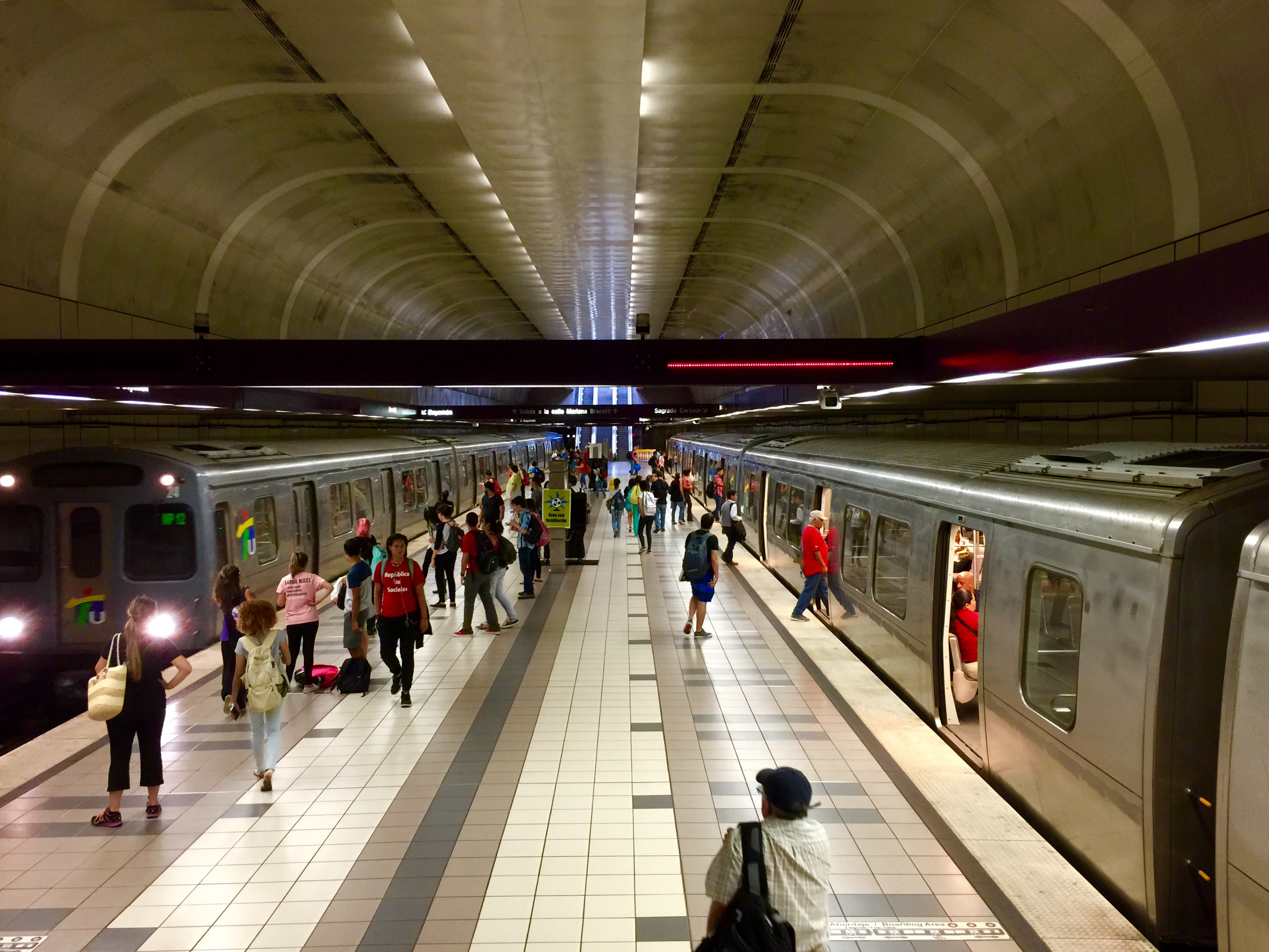
In an attempt to decrease vehicle dependency and road congestion, the city built a metro system dubbed "Tren Urbano" ("Urban Train"). The 10.7-mile (17.2 km) line connects to 16 stations.[119] The project, which opened in late 2004, cost $2.25 billion and was more than $1 billion over budget and four years late. The Tren Urbano has received less ridership than was originally projected and has not significantly reduced the city's automobile traffic, despite a reported 7.5% ridership increase in 2006 over 2005. There is a planned project to build an "interurban light rail system" connecting the cities of San Juan and Caguas.[120]
Increased investment in public transportation, however, has not changed the fact that San Juan is an automobile-reliant city and its fast growth has sparked urban sprawl. As of mid-2010, the government has approved plans for a redesign of this Puerto Rican city, featuring a new mass transit system, new roads and intersections, and more beach-access points. No cars will be allowed inside the oldest part of city (Old San Juan). The plans hope to remedy previous poor urban planning in the oldest section of the city, the Isleta, while curbing reliance on motor vehicles. The plans for redevelopment also hope to make the city more appealing in order to attract new residents, as San Juan has suffered from a shrinking population over the past 60 years.[121]
Port

The Port of San Juan is the fourth busiest seaport in the Western Hemisphere, ranked among the top 17 in the world in terms of container movement. It is also the largest home-based cruise port in the world with over a dozen cruise ships. It is the second busiest port in cruise volume after Miami.[citation needed] It is managed by the Puerto Rico Ports Authority.
AcuaExpreso is a ferry service in the San Juan Bay, consisting of the Cataño Ferry (Lancha de Cataño) service between downtown Cataño and Old San Juan, and the AquaExpress which connects Old San Juan to Hato Rey and the Tren Urbano.[122][123]
Health and utilities

San Juan has an elaborate system of triage, hospital, and preventive care health services. The municipal government sponsors regular health fairs in different areas of the city focusing on health care for the elderly and the disabled. There are 20 hospitals in San Juan, half of them operated by the government. The largest hospital in San Juan and most important of Puerto Rico and the Caribbean[citation needed] is the Rio Piedras Medical Center, or Centro Medico de Rio Piedras in Spanish. This hospital, founded in 1956, is operated by the Medical Services Administration of the Department of Health of Puerto Rico. It is made up of eight other hospitals.
- San Juan Municipal Hospital: This hospital is operated by the San Juan municipal government.
- Industrial Hospital: This is the hospital for Puerto Rico government employees, whether municipal or Commonwealth government employees. Normally, injured police officers and firefighters are cared for here.
- San Juan Pediatric Hospital - Also operated by the San Juan municipal government.
- Pediatric Hospital: Operated by the government of the Commonwealth, this is the main trauma hospital for pediatric cases.
- Centro Médico: This is the main hospital for trauma cases for Puerto Rico and the Caribbean.
- Centro Cardiovascular del Caribe (Caribbean Cardiovascular Center): This is the main hospital for open heart surgery in the Caribbean. It features a hotel for the patients' families.
- Psychiatric Hospital: The main psychiatric hospital in Puerto Rico. Operated by the government of Puerto Rico.
- Psychiatric Correctional Hospital: It is both a hospital and correctional facility. It is operated jointly by the Puerto Rico Department of Corrections and the Medical Services Administration.
The city of San Juan operates 10 hospitals. Of these, nine are Diagnostic and Treatment Centers located in communities throughout San Juan. The main hospital is located at Centro Medico. These 10 hospitals are:
- La Perla
- Puerta de Tierra
- Llorens Torres
- Puerto Nuevo
- San José
- Rio Piedras
- Sabana Llana
- Hoare
- Santurce Parada 19
- General Hospital (Centro Medico)
Also, there are 10 private hospitals in San Juan. These are:
- Hospital Metropolitano
- Hospital Auxilio Mutuo
- Hospital Auxilio Mutuo Expreso
- Hospital de Veteranos: The main Veterans hospital in the Caribbean. Operated by the U.S. Veteran Healthcare System.
- Ashford Presbyterian Hospital
- Hospital Pavia Hato Rey
- Hospital Pavia Santurce
- San Jorge Children's Hospital: The most well-known children's hospital in the San Juan Metropolitan Area.
- Hospital San Gerardo: Located at the Cupey neighborhood, is a small hospital but is also specialized in psychiatry and elderly.
- Hospital del Maestro (Teachers Hospital): Located in Hato Rey, this hospital is operated by the Puerto Rico Teachers Association.
Sports

Teams based in San Juan have been notably successful in athletic competition. The Santurce Crabbers won the National Superior Basketball League championship in 1998, 1999, 2000, 2001 and 2003 during this period being recognized as a dynasty. The San Juan Senators and the Santurce Crabbers were the two major baseball teams in the city, winning the championship of the Puerto Rican Professional Baseball League a total of 17 times. The Santurce Crabbers are located third among teams with more championships in the Caribbean Series, winning championships in the 1951, 1953, 1955, 1993 and 2000 editions of the tournament. The city has also been the host of events within the sports community; some examples include:
- Host of the 1966 Central American and Caribbean Games.[124]
- Host of the 1979 Pan American Games.[125]
- Hosted the Caribbean World Series nine times.[126]
- Major League Baseball's Montreal Expos played 22 home games at Hiram Bithorn Stadium between 2003 and 2004.[127] The team also briefly considered moving permanently to San Juan before relocating to Washington, D.C.
- Hosted the 2006, 2009 and 2013 World Baseball Classic at the Hiram Bithorn Stadium.[128]
- Host of the 1974 FIBA World Championship (basketball).[129]
- Host of the FIBA Americas Championship five times (1980, 1993, 1999, 2003, 2009).
- Hosted the very first edition of World Wrestling Entertainment's pay per view New Year's Revolution was held at the José Miguel Agrelot Coliseum in January 2005.[130]
- The Latin American Regional Special Olympics in February 2010.
- Host of Major League Baseball's 2010 "San Juan Series", three games of the Mets at Marlins held on June 28–30, 2010 at Hiram Bithorn Stadium.
The $28 million San Juan Natatorium attracts island-wide and regional swim meets, as well as winter training by top-rated mainland U.S. colleges and universities, including the United States Military Academy at West Point and the United States Naval Academy at Annapolis.
In July 2007, the San Juan Golf Academy and its driving range began operating atop the city's former sanitary landfill in Puerto Nuevo, and will eventually include the city's first and only 9-hole golf course.
Professional teams
| Club | Sport | League | Venue |
|---|---|---|---|
| Cangrejeros de Santurce | Basketball | Baloncesto Superior Nacional | Roberto Clemente Coliseum |
| Cangrejeros de Santurce | Baseball | Puerto Rico Baseball League | Hiram Bithorn Stadium[131][132] |
| Atléticos de San Juan | Football/Balompié (Soccer) | Puerto Rico Soccer League | |
| Academia Quintana | |||
| San Juan United | Puerto Rico Soccer League Second Division | Sixto Escobar Stadium[133] |
International relations
Diplomatic missions
|
Consulate-General |
Honorary Consulates |
Twin towns – Sister cities
San Juan is twinned with:[152]
|
Domestic
|
International |
Notable people from San Juan
See also
- History of Puerto Rico
- List of former national capitals
- List of national capitals
- List of people from San Juan, Puerto Rico
- List of streets in San Juan, Puerto Rico
- Military history of Puerto Rico
- Spanish Colonial style
Notes
- Mean monthly maxima and minima (i.e. the expected highest and lowest temperature readings at any point during the year or given month) calculated based on data at said location from 1991 to 2020.
- Official records for San Juan were kept at downtown from November 1898 to December 1955 and at Luis Muñoz Marín International Airport since January 1956.[44]
References
- "US Gazetteer files: 2010, 2000, and 1990". United States Census Bureau. February 12, 2011. Archived from the original on August 24, 2019. Retrieved July 5, 2015.
- San Juan, Ciudad Capital Archived October 3, 2020, at the Wayback Machine. SanJuan.pr. Retrieved 2010-12-22.
- "US Board on Geographic Names". United States Geological Survey. July 5, 2015. Archived from the original on February 12, 2012. Retrieved January 31, 2008.
- Bureau, US Census. "PUERTO RICO: 2020 Census". The United States Census Bureau. Retrieved August 25, 2021.
- Magaly Rivera. "San Juan Capital City". Welcome to Puerto Rico. Archived from the original on April 17, 2019. Retrieved May 2, 2007.
- "the San Juan Port" (in Spanish). Puerto Rico Port Authority. 2007. Retrieved May 9, 2007.[dead link]
- "About Puerto Rico". Puerto Rico Tourism Company. 2007. Archived from the original on April 17, 2019. Retrieved May 8, 2007.
- "Nearly two years after Hurricane Maria devastation, Puerto Rico welcomes record number of tourists". ViaHero. April 2, 2019. Archived from the original on November 27, 2019. Retrieved October 16, 2019.
Almost all of Puerto Rico's hotels are open for business.
- "Historia de Puerta de Tierra (San Juan)". www.puertadetierra.info. Retrieved February 12, 2022.
- Rico, Histopedia de Puerto (July 19, 2019). "Caciques y Yucayeques de Borikén". Histopedia de Puerto Rico (in Spanish). Retrieved February 12, 2022.
- "Cacicazgos de los taínos: Antecedentes y desarrollo". EnciclopediaPR. Archived from the original on February 12, 2022. Retrieved February 12, 2022.
- "Guaynabo -- Encyclopædia Britannica" (with history of Puerto Rico),Encyclopædia Britannica, 2006, Britannica.com webpage:EB-Guaynabo-Puerto-Rico Archived October 13, 2007, at the Wayback Machine:names: Caparra, the first Spanish settlement of Puerto Rico (1508).
- "Historic places in Puerto Rico and the Virgin Islands". National Park Service. Archived from the original on May 13, 2007. Retrieved May 2, 2007.
- "American Latino Theme Study: Religion (U.S. National Park Service)". www.nps.gov. Retrieved November 15, 2021.
- Marley, David (2005). Historic Cities of the Americas. Santa Barbara, CA. pp. 185+. ISBN 1576070271.
- "Nueva España documents and transcripts, ca. 1700-ca. 1799". New York Public Library. Archived from the original on January 2, 2016. Retrieved November 21, 2015.
- "Historia de San Juan de Puerto Rico" (in Spanish). Vive San Juan. 2006. Archived from the original on May 1, 2007. Retrieved May 2, 2007.
- Puerto Rico. Russell Schimmer, Genocide Studies Program, Yale University. Archived March 30, 2010, at the Wayback Machine
- "San Juan National Historic Site". National Park Service. 2000. Archived from the original on March 13, 2012. Retrieved May 29, 2007.
- William Figueroa (2000). "History of Puerto Rico" (in Spanish). Sol Boricua. Archived from the original on March 6, 2012. Retrieved May 2, 2007.
- "DON JUAN DE HARO Y LOS HOLANDESES" (24 de Septiembre de 1625) Archived February 2, 2015, at the Wayback Machine
- The History of Puerto Rico From the Spanish Discovery to the American Occupation / Middeldyk, R.A. Van Identifier: etext12272 The History of Puerto Rico From the Spanish Discovery to the American Occupation Archived January 22, 2008, at the Wayback Machine
- José Oquendo. "1898 - Adjuntas en la Guerra Hispanoamericana" (in Spanish). Historia de Adjuntas, Puerto Rico. Archived from the original on March 30, 2012. Retrieved October 10, 2006.
- Miguel J. Hernández. "Erwin Letter from US Marine Alden Morse, at the USS New York, relating the bombing of San Juan del 12 Mayo 1898". Coquí.Net. Archived from the original on March 1, 2012. Retrieved May 8, 2007.
- "1898 - Adjuntas en la Guerra Hispanoamericana" (in Spanish). Archived from the original on March 30, 2012. Retrieved October 10, 2006.
- "Chronology of Puerto Rico in the Spanish–American War". The World of 1898: The Spanish–American War. Hispanic Division, Library of Congress. Archived from the original on January 4, 2018. Retrieved August 4, 2008.
- Karl Stephen Herrman (2004). From Yauco to Las Marias a Recent Campaign in Puerto Rico. Kessinger Publishing. p. 2. ISBN 1-4191-2123-5.
- "History of the 65th Infantry 1898 to 1946 page 1". Archived from the original on February 2, 2015. Retrieved May 23, 2015.
- "US Naval Institute Proceedings"; "A Breach of Neutrality"; by: Lt. Isaiah Olch, US Navy; Vol. 62; July - December 1936
- "CALLS ODENWALD AFFAIR AN ATTACK; Fired On Without Warning Shot, Germany Asserts, Contradicting San Juan Commander. SAYS SHE WAS UNDULY HELD Violated Clearance to Elude Enemy Cruisers That Had Been Warned She Was About to Sail". The New York Times. April 7, 1915. Archived from the original on October 3, 2020. Retrieved August 10, 2008.
- "PR - A Commonwealth of the USA". Archived from the original on February 3, 2015. Retrieved May 23, 2015.
- "El Mundo"; "Fallece El Aguila - Fue Primer Boricua Manejo Avion en la Isla" (Spanish); by: Malen Rojas Daporte; October 20, 1954; Number 13,448
- "El Nuevo Dia". Archived from the original on May 2, 2009. Retrieved May 11, 2009.
- "heroe del 65 Satisfecho de Haber Cumplido su Deber"; El Mundo; May 2, 1952
- El ataque Nacionalista a La Fortaleza; by Pedro Aponte Vázquez; Page 2; Publisher: Publicaciones RENÉ; ISBN 978-1-931702-01-0
- "Puerto Rico Geography". ToPuertoRico.org. Archived from the original on March 19, 2012. Retrieved June 30, 2007.
- "Áreas naturales protegidas y bosques urbanos". Estuario (in European Spanish). October 2, 2019. Retrieved February 12, 2022.
- "NowData - NOAA Online Weather Data". National Oceanic and Atmospheric Administration. Retrieved June 17, 2021.
- "Monthly Averages for San Juan, PR – Temperature and Precipitation". The Weather Channel. Retrieved April 16, 2011.
- "Climate information for San Juan Intl. Airport". Archived from the original on February 24, 2012. Retrieved June 1, 2007.
- "WMO Climate Normals for SAN JUAN/ISLA VERDE INT'L ARP,PR 1961–1990". National Oceanic and Atmospheric Administration. Retrieved March 10, 2014.
- "Preliminary Locations of Landslide Impacts from Hurricane Maria, Puerto Rico". USGS Landslide Hazards Program. USGS. Archived from the original on March 3, 2019. Retrieved March 3, 2019.
- "Preliminary Locations of Landslide Impacts from Hurricane Maria, Puerto Rico" (PDF). USGS Landslide Hazards Program. USGS. Archived (PDF) from the original on March 3, 2019. Retrieved March 3, 2019.
- ThreadEx
- "Station: San Juan L M Marin AP, PR RQ". U.S. Climate Normals 2020: U.S. Monthly Climate Normals (1991-2020). National Oceanic and Atmospheric Administration. Retrieved June 17, 2021.
- "San Juan, Puerto Rico, USA - Monthly weather forecast and Climate data". Weather Atlas. Retrieved July 4, 2019.
- "DRNA |". DRNA. Retrieved January 21, 2022.
- "Playa Escambron - San Juan Puerto Rico - Visitor's Guide w/ Photos, Map, Nearby Hotels". San Juan Puerto Rico. June 19, 2021. Retrieved January 21, 2022.
- "Playa Último Trolley (Playa Ocean Park)". Discover Puerto Rico. Retrieved January 21, 2022.
- "Ocean Park Beach - San Juan, Puerto Rico - Must Read for Tourists". San Juan Puerto Rico. November 9, 2020. Retrieved January 21, 2022.
- "CORREDOR ECOLÓGICO DE SAN JUAN — Puerto DRNA "Navega por el ambiente"". April 12, 2012. Archived from the original on April 12, 2012. Retrieved January 21, 2022.
- Ramah, Mailing Address: HC 61 Box 43; Us, NM 87321 Phone: 505 783-4226 x801 Contact. "Night Skies - El Morro National Monument (U.S. National Park Service)". www.nps.gov. Retrieved January 21, 2022.
- "Kite flying at El Morro Old San Juan | Discovering Puerto Rico". March 15, 2007. Retrieved January 21, 2022.
- "La Loma Del Viento". Discover Puerto Rico. Retrieved January 21, 2022.
- "NPGallery Asset Detail". npgallery.nps.gov. Retrieved January 21, 2022.
- "NPGallery Asset Detail". npgallery.nps.gov. Retrieved January 21, 2022.
- "Antiguo Acueducto del Río Piedras | National Trust for Historic Preservation". savingplaces.org. Retrieved January 21, 2022.
- "ZeePuertoRico.com - Enrique Martí Coll Lineal Park". www.zeepuertorico.com. Retrieved January 21, 2022.
- "Lugares para correr bicicleta en Puerto Rico". www.zeepuertorico.com. Retrieved January 21, 2022.
- "Visit Parque Luis Munoz Marin on your trip to San Juan or Puerto Rico". www.inspirock.com. Retrieved January 21, 2022.
- "Áreas naturales protegidas y bosques urbanos". Estuario (in European Spanish). October 2, 2019. Retrieved January 21, 2022.
- "Puerto Rico Natural Protected Areas (December 2016 Inventory) | The Caribbean LCC CPA". caribbeanlcc.databasin.org. Retrieved January 21, 2022.
- Grupo Editorial EPRL. "Viejo San Juan". Enciclopedia Puerto Rico. Archived from the original on July 23, 2013. Retrieved November 4, 2012.
- "San Juan map: Municipo de San Juan" (PDF). Welcome.topuertorico.org. Archived (PDF) from the original on October 3, 2020. Retrieved November 25, 2012.
- "Los Castillos del Viejo San Juan" (in Spanish). National Park Service. Archived from the original on April 12, 2012. Retrieved May 6, 2007.
- Archived October 10, 2009, at the Wayback Machine
- "History of El Cuartel de Ballajá" (in Spanish). Coquí.Net. Archived from the original on March 5, 2012. Retrieved May 3, 2007.
- E. Ramirez Brau (2005). "Viejo Cementerio de San Juan (graveyard's history)" (in Spanish). Archived from the original on January 16, 2007. Retrieved February 3, 2007.
- "Teatro Tapia". Yahoo Travel. Archived from the original on March 6, 2012. Retrieved May 3, 2007.
- "Official Web Site of the Cathedral of San Juan Bautista" (in Spanish). Archived from the original on March 1, 2012. Retrieved May 3, 2007.
- "Puerto Rico Cheap Hotels: Condado, Old San Juan, Isla Verde and Ocean Park budget hotels". Hola San Juan. 2007. Archived from the original on April 19, 2018. Retrieved May 6, 2007.
- "Informese: Miramar designated a historical district". MiramarPR. 2007. Archived from the original on October 14, 2007. Retrieved May 6, 2007.
- "Official site of the Museo de Arte de Puerto Rico" (in Spanish). Museo de Arte de Puerto Rico. 2006. Archived from the original on March 6, 2012. Retrieved May 6, 2007.
- Brenda A. Mari (November 19, 2004). "Eatin' Where The Cows Used To Roam: Hato Rey Dining At Its Best". The Puerto Rico Herald. Archived from the original on November 24, 2004. Retrieved May 6, 2007.
- "Official site of the University of Puerto Rico" (in Spanish). Universidad de Puerto Rico. 2007. Archived from the original on March 6, 2012. Retrieved May 6, 2007.
- Data Access and Dissemination Systems (DADS). "U.S. Census website". Archived from the original on December 27, 1996. Retrieved May 23, 2015.
- "U.S. CENSUSES OF POPULATION and HOUSING: 1960 Final Report PHC(1) - 180, Census Tracts, San Juan, P.R." (PDF). census.gov. p. 29.
- "San Juan and its barrios". United States Census Bureau. 2008. Archived from the original on February 12, 2020. Retrieved October 26, 2009.
- "American FactFinder". Factfinder.census.gov. Archived from the original on February 11, 2020. Retrieved November 25, 2012.
- "American FactFinder". Factfinder.census.gov. Archived from the original on February 11, 2020. Retrieved November 25, 2012.
- Cities and the Wealth of Nations, Chapter 3, Jane Jacobs, 1984
- Microsoft Encarta Biblioteca (2006), Microsoft Corporation
- "General Info" (Archive). Seaborne Airlines. Retrieved on April 18, 2015. "Mailing Address: Seaborne Airlines World Plaza Building, 9th Floor 268 Muñoz Rivera Ave. San Juan, Puerto Rico 00918"
- Puerto Rico, Borinquen Querida - Authors; Roger A. LaBrucherie, Imágenes Press, (1992) ISBN 0-939302-26-8
- "Nearly two years after Hurricane Maria devastation, Puerto Rico welcomes record number of tourists". USA Today. April 2, 2019. Archived from the original on November 27, 2019. Retrieved November 27, 2019.
Brief power outages still hit occasionally as the government prepares to privatize an aging and poorly maintained grid that was destroyed by the hurricane, and water shortages have hit parts of Puerto Rico's north coast since 30 percent of the island is experiencing a moderate drought that is affecting 791,000 of its 3.2 million inhabitants.
- "Nearly two years after Hurricane Maria devastation, Puerto Rico welcomes record number of tourists". ViaHero. April 2, 2019. Archived from the original on November 27, 2019. Retrieved October 16, 2019.
Almost all of Puerto Rico's hotels are open for business. The beaches are ready for swimming and sunbathing, and even remote places to visit like El Yunque rainforest are receiving visitors.
- "Cruise Ship Visits to San Juan, Puerto Rico Are Being Canceled". Cruise Hive. November 27, 2019. Archived from the original on November 27, 2019. Retrieved November 27, 2019.
Cruise ship visits to San Juan, Puerto Rico are being canceled for the 2020-21 season due to the privatization of the cruise port.
- Jones, Chris. "'Hamilton' opens in Puerto Rico with emotional performance by Lin-Manuel Miranda: 'I just love this island so much'". chicagotribune.com. Retrieved September 23, 2021.
- "Colección Permanente" (in Spanish). Museo de Arte de Puerto Rico. Archived from the original on April 30, 2007. Retrieved June 11, 2007.
- "Colección Parmanente" (in Spanish). Museo de Arte Contemporaneo de Puerto Rico. 2004. Archived from the original on June 23, 2012. Retrieved June 11, 2007.
- "Orígenes, historia y misión del Museo" (in Spanish). Museo las Americas. 2007. Archived from the original on March 7, 2012. Retrieved June 11, 2007.
- "Galería Nacional, Viejo San Juan". Instituto de Cultura Puertoriqueña. 2003. Archived from the original on June 18, 2007. Retrieved June 11, 2007.
- "Historia del Museo del Niño" (in Spanish). Museo del Niño. Archived from the original on June 5, 2007. Retrieved June 11, 2007.
- "Puerto Rico Attractions and Museums". Archived from the original on October 17, 2007. Retrieved June 11, 2007.
- "Historia de San Juan: Casa Alcaldía" (in Spanish). Municipio de San Juan. Archived from the original on February 25, 2009. Retrieved January 28, 2010.
- "San Juan Results". ceepur.org. December 31, 2020.
- "Historia breve de la Asamblea Municipal" (in Spanish). Municipio de San Juan. Archived from the original on July 17, 2013. Retrieved January 28, 2010.
- "Ley Núm. 70 de 2006 -Ley para disponer la oficialidad de la bandera y el escudo de los setenta y ocho (78) municipios". LexJuris de Puerto Rico (in Spanish). Retrieved June 15, 2021.
- "San Juan". LexJuris (Leyes y Jurisprudencia) de Puerto Rico (in Spanish). February 19, 2020. Archived from the original on February 19, 2020. Retrieved September 17, 2020.
- "San Juan (Puerto Rico)". Archived from the original on October 3, 2020. Retrieved May 23, 2015.
- Distribución de Distritos Senatoriales de Puerto Rico Archived November 16, 2011, at the Wayback Machine on ElectionsPuertoRico
- "San Juan se coloca como la segunda capital con más asesinatos en Latinoamérica". Primera Hora (in Spanish). March 8, 2020. Retrieved August 26, 2021.
- "Departamento de Policía y Seguridad Pública" (in Spanish). Municipio de San Juan. Archived from the original on November 15, 2007. Retrieved January 28, 2010.
- Leysa Caro González (June 30, 2008). "De negro bajo el sol". Primera Hora (in Spanish). Archived from the original on June 28, 2009. Retrieved January 28, 2010.
- "Periódicos diarios de Puerto Rico - Puertorriqueños". www.prensaescrita.com. Retrieved October 11, 2021.
- "The San Juan Daily Star | Puerto Rico | About". sjds. Retrieved October 11, 2021.
- "Puerto Rican Newspapers". www.w3newspapers.com. Retrieved October 11, 2021.
- "Emisoras de Radio de San Juan, Puerto Rico - Escuchar Online - myTuner Radio". mytuner-radio.com. Retrieved October 11, 2021.
- "Puerto Rico Television Stations - Station Index". www.stationindex.com. Retrieved October 11, 2021.
- Howell, Douglas. "10 Películas Excelentes Filmadas En Puerto Rico - 2021". yourtripagent.com (in European Spanish). Retrieved October 11, 2021.
- "20 películas grabadas en Puerto Rico". PR Gamer. May 13, 2015. Retrieved October 11, 2021.
- "Puerto Rico Colleges and Universities". Infoplease. 2006. Archived from the original on November 3, 2011. Retrieved June 25, 2007.
- "Caribbean International Airports". www.caribbeanislands.com. Retrieved February 12, 2022.
- "Autoridad de puertos de Puerto Rico official website" (in Spanish). Autoridad de Puertos de Puerto Rico. Archived from the original on October 7, 2009. Retrieved May 8, 2007.
- "San Juan Bridges". National Bridge Inventory Data. US Dept. of Transportation. Archived from the original on October 3, 2020. Retrieved February 20, 2019.
- Highest auto density in the world Archived January 1, 2010, at the Wayback Machine
- "About Puerto Rico...San Juan". Dollarman.com. Archived from the original on March 6, 2012. Retrieved May 11, 2007.
- "AMA: Descripción" (in Spanish). Departamento de Transportación Publica. 2006. Archived from the original on May 2, 2007. Retrieved June 25, 2007.
- "Alternativa de Transporte Integrado homepage" (in Spanish). Departamento de Trasportación Publica. 2006. Archived from the original on May 5, 2007. Retrieved May 8, 2007.
- "Caguas To San Juan In 15 Minutes". Puerto Rico Herald. 2007. Archived from the original on September 27, 2007. Retrieved May 8, 2007.
- "Walkable City San Juan". Issuu. 2010. Archived from the original on October 3, 2020. Retrieved August 10, 2010.
- "Larga historia en la lancha de Cataño". El Nuevo Día (in Spanish). May 8, 2016. Retrieved February 12, 2022.
- "Government's page on Lancha de Cataño's economical impact" (in Spanish). Gobierno de Puerto Rico. 2007. Archived from the original on March 11, 2007. Retrieved May 8, 2007.
- "Historia de los Juegos Centro Americanos y del Caribe" (in Spanish). Unión Pan Americana de Judo. 1998. Archived from the original on April 21, 2007. Retrieved May 6, 2007.
- "VIII Pan American Games". LA84 Foundation. Archived from the original on June 2, 2008. Retrieved May 6, 2007.
- "Caribbean World Series Historical Statistics 2005". Latino Baseball. 2005. Archived from the original on February 13, 2007. Retrieved May 6, 2007.
- Josh Dubow (2003). "Expos odyssey takes them back to Puerto Rico". SingOnSanDiego.com. Archived from the original on November 5, 2011. Retrieved May 6, 2007.
- "Official site of the World Baseball Classic". World Baseball Classic. 2006. Archived from the original on May 9, 2007. Retrieved May 6, 2007.
{{cite web}}: CS1 maint: bot: original URL status unknown (link) - "Year by Year Champions". Fiba. Archived from the original on March 6, 2012. Retrieved May 6, 2007.
- "New Year's revolution Pay-Per-View history". World Wrestling Entertainment. 2005. Archived from the original on October 26, 2012. Retrieved May 6, 2007.
- "Afiliados: Atlético San Juan Fútbol Club" (in Spanish). Federación Puertorriqueña de Fútbol. Archived from the original on November 21, 2008. Retrieved February 10, 2010.
- "Afiliados: Professional Team Academia Quintana FC" (in Spanish). Federación Puertorriqueña de Fútbol. Archived from the original on November 21, 2008. Retrieved February 9, 2010.
- "Afiliados: San Juan United Soccer Club, Corp" (in Spanish). Federación Puertorriqueña de Fútbol. Archived from the original on July 27, 2009. Retrieved February 9, 2010.
- "| Consulado de Colombia en San Juan". sanjuan.consulado.gov.co. Retrieved October 21, 2021.
- "Consulate General of the Dominican Republic in San Juan, Puerto Rico".
- "Consulado General de México en San Juan, Puerto Rico". consulmex.sre.gob.mx. Retrieved October 21, 2021.
- "Páginas - Consulado de España en San Juan de Puerto Rico". www.exteriores.gob.es. Archived from the original on October 20, 2021. Retrieved October 21, 2021.
- "Consulado de Venezuela en Puerto Rico, San Juan". www.municipio.co.ve. Retrieved October 21, 2021.
- "Consulado Itinerante en Puerto Rico". Argentina.gob.ar (in Spanish). September 24, 2018. Retrieved October 21, 2021.
- "Meet the Consul". Austria. Retrieved October 21, 2021.
- "Embassies and Consulates in Puerto Rico". welcome.topuertorico.org. Retrieved October 21, 2021.
- Canada, Global Affairs (September 23, 2019). "Consulate of Canada in San Juan, Puerto Rico". GAC. Retrieved October 21, 2021.
- Consulares, Servicios. "Consulado Honorario en San Juan Puerto Rico". Servicios Consulares (in Spanish). Retrieved October 21, 2021.
- "LISTA DE CONSULADOS DE COSTA RICA EN E.E.U.U | Embajada de Costa Rica en DC". www.costarica-embassy.org. Retrieved October 21, 2021.
- "Consulado de Republica Checa en San Juan". www.123embajada.com. Retrieved October 21, 2021.
- "Consulado de Ecuador en San Juan, Puerto Rico".
- "Consulado Honorario de Francia en San Juan, Puerto Rico".
- "Consular Offices". Embassy of Haiti. Retrieved October 21, 2021.
- "Consulate of Switzerland in San Juan / Puerto Rico". www.eda.admin.ch. Retrieved October 21, 2021.
- "The British Consulate in San Juan". www.british-consulate.net. Retrieved October 21, 2021.
- "Consulado de Uruguay en Puerto Rico, San Juan". www.municipio.uy. Retrieved October 21, 2021.
- "Meet Jacksonville's Eight International "Sister Cities"". thecoastal.com. The Coastal. April 20, 2020. Retrieved December 22, 2021.
- "Sister Cities - Honolulu - Open Data Portal". Socrata. Archived from the original on December 27, 2017. Retrieved May 23, 2015.
- "Sister Cities Link Businesses, Create Opportunities". Archived from the original on November 17, 2014. Retrieved May 23, 2015.
- "Killeen and San Juan, Puerto Rico now "sister cities" -kcentv.com - KCEN HD - Waco, Temple, and Killeen". Centraltexasnow.com. December 12, 2010. Archived from the original on July 29, 2012. Retrieved November 25, 2012.
Bibliography
External links
- City of San Juan
- National Park Service – San Juan
- Historic Places in Puerto Rico and the Virgin Islands, a National Park Service Discover Our Shared Heritage Travel Itinerary
- National Weather Service – San Juan, Puerto Rico
- San Juan Puerto Rico
Places adjacent to San Juan, Puerto Rico | ||||||||||||||||
|---|---|---|---|---|---|---|---|---|---|---|---|---|---|---|---|---|
| ||||||||||||||||
| ||
| Barrios |
|  |
Pan American Games host cities | |
|---|---|
| Summer |
|
| Winter |
|
Commonwealth of Puerto Rico | |
|---|---|
San Juan (capital) | |
| Metropolitan areas |
|
| Municipalities |
|
| Islands | |
| Geography |
|
| Topics | |
Authority control | |
|---|---|
| General | |
| National libraries | |
| Other |
|
На других языках
[de] San Juan (Puerto Rico)
San Juan ist die Hauptstadt des US-amerikanischen Außengebietes Puerto Rico, einem Inselstaat in der Karibik. Die Stadt im Nordosten der Insel selbst hat 342.259 Einwohner, ihre Agglomeration zählt 2.081.265 Menschen (Volkszählung 2020). Die größte Stadt des Inselstaats ist das industrielle, wirtschaftliche, kulturelle und touristische Zentrum der Insel und beheimatet deren wichtigsten Seehafen.- [en] San Juan, Puerto Rico
Другой контент может иметь иную лицензию. Перед использованием материалов сайта WikiSort.org внимательно изучите правила лицензирования конкретных элементов наполнения сайта.
WikiSort.org - проект по пересортировке и дополнению контента Википедии