world.wikisort.org - USA
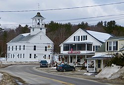
North Sutton is an unincorporated community in the town of Sutton in Merrimack County, New Hampshire, United States. It is located at the eastern end of Kezar Lake, adjacent to Wadleigh State Park.
North Sutton, New Hampshire | |
|---|---|
Unincorporated community | |
 | |
 North Sutton  North Sutton | |
| Coordinates: 43°21′50″N 71°56′22″W | |
| Country | United States |
| State | New Hampshire |
| County | Merrimack |
| Town | Sutton |
| Elevation | 915 ft (279 m) |
| Time zone | UTC-5 (Eastern (EST)) |
| • Summer (DST) | UTC-4 (EDT) |
| ZIP code | 03260 |
| Area code(s) | 603 |
| GNIS feature ID | 868818[1] |
New Hampshire Route 114 passes through the village, leading north to New London and south to Sutton Village, South Sutton and Bradford. Interstate 89 passes just east of the village, which can be accessed from Exit 10.
North Sutton has a separate ZIP code (03260) from other parts of the town of Sutton.
Sites of interest
Kezar Lake, with its 3-mile (5 km) loop of lightly traveled country roads, is a popular local destination for walkers, joggers, and dog walkers.
Muster Field Farm, a working farm and New Hampshire agricultural learning center and museum, is on Harvey Road 1 mile (1.6 km) northwest of the center of North Sutton.
References
- "North Sutton". Geographic Names Information System. United States Geological Survey.

Другой контент может иметь иную лицензию. Перед использованием материалов сайта WikiSort.org внимательно изучите правила лицензирования конкретных элементов наполнения сайта.
WikiSort.org - проект по пересортировке и дополнению контента Википедии
