world.wikisort.org - USA
Franklin is a city in Merrimack County, New Hampshire, United States. At the 2020 census, the population was 8,741,[2] the least of New Hampshire's 13 cities. Franklin includes the village of West Franklin.
Franklin, New Hampshire | |
|---|---|
City | |
 Central Street | |
 Seal | |
| Motto: "The Three Rivers City" | |
 Location within Merrimack County, and the state of New Hampshire. | |
| Coordinates: 43°26′39″N 71°38′51″W | |
| Country | United States |
| State | New Hampshire |
| County | Merrimack |
| Settled | 1764 |
| Incorporated (Town) | 1828 |
| Government | |
| • Mayor | Jo Brown |
| • City Council | Members
|
| • City Manager | Judie Milner |
| Area | |
| • Total | 29.17 sq mi (75.55 km2) |
| • Land | 27.43 sq mi (71.05 km2) |
| • Water | 1.74 sq mi (4.50 km2) 5.95% |
| Elevation | 310 ft (90 m) |
| Population (2020) | |
| • Total | 8,741 |
| • Density | 318.63/sq mi (123.03/km2) |
| Time zone | UTC−5 (EST) |
| • Summer (DST) | UTC−4 (EDT) |
| ZIP code | 03235 |
| Area code | 603 |
| FIPS code | 33-27380 |
| GNIS feature ID | 0873290 |
| Website | www |
History
Situated at the confluence of the Pemigewasset and Winnipesaukee rivers that form the Merrimack River, the town was settled by Anglo-European colonists in 1764 and originally known as "Pemigewasset Village". It was taken from portions of Salisbury, Andover, Sanbornton and Northfield. The name "Franklin" was adopted in 1820 in honor of statesman and founding father Benjamin Franklin. Water power from the falls on the Winnipesaukee River helped it develop as a mill town.[3] It incorporated as a town in 1828, and then as a city in 1895.
Daniel Webster was born in a section of Franklin that was then part of Salisbury. There is a state historic site located off Route 127 that preserves the famous orator's childhood home. As an adult, Webster owned "The Elms", a farm near the Merrimack River along present-day Route 3.
In 1943, the Army Corps of Engineers created the Franklin Falls Reservoir above Franklin by constructing the Franklin Falls Dam for flood control on the Pemigewasset River.
Image gallery
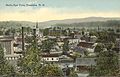 Bird's eye view c. 1912
 Merrimack River in 1905
 Old High School in 1908
 Central Street in 1909
 Sulloway Mills c. 1910
 Daniel Webster birthplace c. 1910
 City Hall
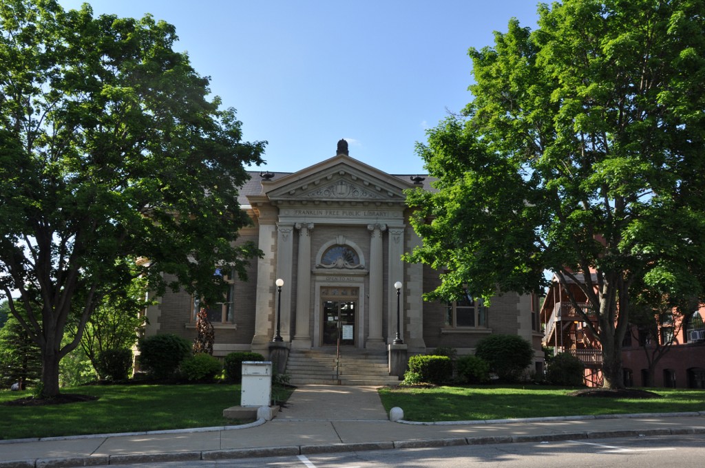
 The library


Geography
Franklin is located in northern Merrimack County at 43°26′49″N 71°39′25″W (43.446956, −71.656966).[4]
According to the United States Census Bureau, the city has a total area of 29.2 square miles (75.5 km2), of which 27.5 square miles (71.1 km2) are land and 1.7 square miles (4.5 km2) are water, comprising 5.95% of the town.[5] It is drained by the Winnipesaukee, Pemigewasset and Merrimack rivers. Webster Lake is in the north. The highest point in Franklin is an unnamed summit near the northwestern corner of the city limits, where the elevation reaches approximately 1,370 feet (420 m) above sea level. Franklin lies fully within the Merrimack River watershed.[6]
U.S. Route 3 and New Hampshire Route 11 form Central Street, the main street of Franklin. Heading east, the two routes lead to Tilton and Laconia. US 3 leads south to Boscawen and Concord, while NH 11 goes west to Andover and New London. New Hampshire Route 127 also passes through downtown Franklin, leading southwest to Salisbury and Contoocook, and north into Sanbornton. New Hampshire Route 3A leads north from West Franklin to Bristol.
Adjacent municipalities
- Sanbornton (northeast)
- Tilton (east)
- Northfield (southeast)
- Boscawen (south)
- Salisbury (southwest)
- Andover (west)
- Hill (northwest)
Demographics

| Historical population | |||
|---|---|---|---|
| Census | Pop. | %± | |
| 1830 | 1,370 | — | |
| 1840 | 1,281 | −6.5% | |
| 1850 | 1,251 | −2.3% | |
| 1860 | 1,600 | 27.9% | |
| 1870 | 2,301 | 43.8% | |
| 1880 | 3,265 | 41.9% | |
| 1890 | 4,085 | 25.1% | |
| 1900 | 5,846 | 43.1% | |
| 1910 | 6,132 | 4.9% | |
| 1920 | 6,318 | 3.0% | |
| 1930 | 6,576 | 4.1% | |
| 1940 | 6,749 | 2.6% | |
| 1950 | 6,552 | −2.9% | |
| 1960 | 6,742 | 2.9% | |
| 1970 | 7,292 | 8.2% | |
| 1980 | 7,901 | 8.4% | |
| 1990 | 8,304 | 5.1% | |
| 2000 | 8,405 | 1.2% | |
| 2010 | 8,477 | 0.9% | |
| 2020 | 8,741 | 3.1% | |
| U.S. Decennial Census[2][7] 1767-1786: NH Provincial & State Papers[8] | |||
As of the census of 2010, there were 8,477 people, 3,407 households, and 2,179 families residing in the city. There were 3,938 housing units, of which 531, or 13.5%, were vacant. 193 of the vacant units were for seasonal or recreational use. The racial makeup of the town was 96.2% white, 0.5% African American, 0.5% Native American, 0.8% Asian, 0.02% Native Hawaiian or Pacific Islander, 0.3% some other race, and 1.7% from two or more races. 1.6% of the population were Hispanic or Latino of any race.[9]
Of the 3,407 households, 30.8% had children under the age of 18 living with them, 44.8% were headed by married couples living together, 13.5% had a female householder with no husband present, and 36.0% were non-families. 28.4% of all households were made up of individuals, and 11.8% were someone living alone who was 65 years of age or older. The average household size was 2.43, and the average family size was 2.93.[9]
In the city, 22.3% of the population were under the age of 18, 8.0% were from 18 to 24, 25.6% from 25 to 44, 29.0% from 45 to 64, and 15.1% were 65 years of age or older. The median age was 40.2 years. For every 100 females, there were 91.7 males. For every 100 females age 18 and over, there were 88.9 males.[9]
For the period 2011–2015, the estimated median annual income for a household was $43,237, and the median income for a family was $52,390. Male full-time workers had a median income of $43,179 versus $34,708 for females. The per capita income for the city was $22,318. 21.1% of the population and 16.6% of families were below the poverty line. 40.2% of the population under the age of 18 and 12.5% of those 65 or older were living in poverty.[10]
Education
- Franklin High School
Sites of interest
- Sulphite Railroad Bridge (the "upside-down" railroad bridge)
- Daniel Webster Birthplace State Historic Site
Notable people
- Jedh Barker (1945–1967), U.S. Marine; posthumously received the Medal of Honor
- Vaughn Blanchard (1889–1969), Olympic track and field athlete
- Cornelia James Cannon (1876–1969), feminist reformer
- Walter Bradford Cannon (1871–1945), physiologist
- Warren F. Daniell (1826–1913), manufacturer, stock breeder, banker, U.S. congressman
- Ram Dass (1931–2019), spiritual leader (occasional resident)[11]
- John King Fairbank (1907–1991), historian (summer resident)
- Robert Moller Gilbreth (1920–2007), New Hampshire state legislator, educator, businessman
- Robert M. Leach (1879–1952), U.S. congressman
- G. W. Pierce (1872–1956), professor of physics at Harvard University and inventor in the development of electronic telecommunications
- Katherine Call Simonds (1865–1946), musician, dramatic soprano, author, composer
- Daniel Webster (1782–1852), Secretary of State, U.S. senator, congressman
References
- "ArcGIS REST Services Directory". United States Census Bureau. Retrieved September 20, 2022.
- "Franklin city, Merrimack County, New Hampshire: 2020 DEC Redistricting Data (PL 94-171)". U.S. Census Bureau. Retrieved December 13, 2021.
- Coolidge, Austin J.; John B. Mansfield (1859). A History and Description of New England. Boston, Massachusetts. pp. 497–499.
- "US Gazetteer files: 2010, 2000, and 1990". United States Census Bureau. 2011-02-12. Retrieved 2011-04-23.
- "2021 U.S. Gazetteer Files – New Hampshire". United States Census Bureau. Retrieved December 13, 2021.
- Foster, Debra H.; Batorfalvy, Tatianna N.; Medalie, Laura (1995). Water Use in New Hampshire: An Activities Guide for Teachers. U.S. Department of the Interior and U.S. Geological Survey.
- "U.S. Decennial Census". Census.gov. Retrieved November 4, 2014.
- "State of NH Historic Population" (PDF). nh.gov. Retrieved April 20, 2021.
- "Profile of General Population and Housing Characteristics: 2010 Census Summary File 1 (DP-1): Franklin city, New Hampshire". American Factfinder. U.S. Census Bureau. Archived from the original on February 13, 2020. Retrieved November 2, 2017.
- "Selected Economic Characteristics: 2011-2015 American Community Survey 5-Year Estimates (DP03): Franklin city, New Hampshire". American Factfinder. U.S. Census Bureau. Archived from the original on February 13, 2020. Retrieved November 2, 2017.
- Ram Dass Channel. "Ram Dass in Franklin New Hampshire 1969". YouTube. Archived from the original on 2012-03-05. Retrieved 23 March 2017.
External links
- Official website
- Franklin Public Library
- Franklin Historical Society
- Franklin Opera House
- New Hampshire Economic and Labor Market Information Bureau Profile
Places adjacent to Franklin, New Hampshire | ||||||||||||||||
|---|---|---|---|---|---|---|---|---|---|---|---|---|---|---|---|---|
| ||||||||||||||||
Municipalities and communities of Merrimack County, New Hampshire, United States | ||
|---|---|---|
County seat: Concord | ||
| Cities |  | |
| Towns | ||
| CDPs | ||
| Other communities | ||
| Footnotes | ‡This populated place also has portions in an adjacent county or counties | |
| ||
Authority control | |
|---|---|
| General | |
| National libraries | |
На других языках
[de] Franklin (New Hampshire)
Franklin ist eine Stadt (city) im US-Bundesstaat New Hampshire. Sie hatte im Jahr 2020 8.741 Einwohner[1] und liegt im Merrimack County. Zur Stadt gehört auch das Dorf West Franklin.- [en] Franklin, New Hampshire
Другой контент может иметь иную лицензию. Перед использованием материалов сайта WikiSort.org внимательно изучите правила лицензирования конкретных элементов наполнения сайта.
WikiSort.org - проект по пересортировке и дополнению контента Википедии