world.wikisort.org - USA
Carbon County is a county located in Northeastern Pennsylvania. As of the 2020 census, the population was 64,749.[2] The county is also part of Pennsylvania's Coal Region and Northeastern Pennsylvania.
Carbon County | |
|---|---|
U.S. county | |
 Blue Mountain near Palmerton in Carbon County, March 2007 | |
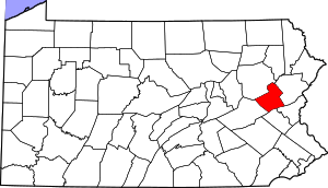 Location within the U.S. state of Pennsylvania | |
 Pennsylvania's location within the U.S. | |
| Coordinates: 40°55′N 75°42′W | |
| Country | |
| State | |
| Founded | March 13, 1843 (Divided from Northampton County |
| Named for | Coal deposits |
| Seat | Jim Thorpe |
| Largest borough | Palmerton |
| Area | |
| • Total | 387 sq mi (1,000 km2) |
| • Land | 381 sq mi (990 km2) |
| • Water | 5.9 sq mi (15 km2) 2%% |
| Population | |
| • Estimate (2020) | 64,749 |
| • Density | 170/sq mi (70/km2) |
| Time zone | UTC−5 (Eastern) |
| • Summer (DST) | UTC−4 (EDT) |
| Congressional district | 9th |
| Website | carboncounty |
Pennsylvania Historical Marker | |
| Designated | June 13, 1982[1] |
The county seat of Carbon County is Jim Thorpe,[3] which was founded in 1818 as Mauch Chunk and served as a company town of the Lehigh Coal & Navigation Company. The Lehigh River, a 109-mile-long (175 km) tributary of the Delaware River, flows through Carbon County.
History
Moravian settlement
In 1745, the first settlement in Carbon County was established by a Moravian mission in Gnadenhutten, which is present day Lehighton. Deeply moved by the deplorable state of the Leni Lenape Indians in America, twelve Moravian missionaries left their home in Herrnhut, Germany and traveled by sea to the wilderness of Pennsylvania, a place known for religious tolerance under the auspices of Count Zinzendorf. Located where Lehighton now stands, Gnadenhutten exemplified communal simplicity. Home to hundreds of Lenape and Mohican Indians displaced by colonial settlements, predation, bigotry and subjugation to the Iroquois, the Delaware peoples were being squeezed out of the southern counties and New Jersey westwards and against the Blue Ridge escarpment. The mission was a scene of quiet, humble and unobtrusive heroism and the Indians' shelter. Although the wilderness of Carbon County was quite treacherous, the Moravians traveled in the wilds of Carbon County undaunted. By 1752, increased hostility put Gnadenhutten at risk for attack, but the missionaries' pious good works did not go unnoticed. The frankness and earnestness of the simple Moravians had won respect with the many tribes of Pennsylvania Indians, and they lived without incident until 1755.[4] At that point an Amerindian uprising drove settlements away from the Lehigh Gap, and whites didn't reenter the area before the late 1780.[5] In 1791, a homesteader, Phillip Ginter hunting on Sharp Mountain along Pisgah Ridge[6] found a black tone coal outcropping, and conveyed a chunk of it to Weissport.
Industrialization

Lehigh Coal Mine Company (LCMC) operations had managed to open up the mouth area of the Nesquehoning Creek by 1800. This area became known as Lausanne, or Lausanne Landing, after the Inn & Tavern built there called Landing Tavern. An Amerindian trail crossed the stream near the confluence with Jean's Run[7] and the camp grounds of their boat builders, climbing northwestwards along a traverse to the next water gap west, eroded into the southern flank of Broad Mountain in the Lehigh Valley. It connected across a barrier ridge whose waters originated in the saddle-pass in which Hazleton, Pennsylvania was built. The trail would become the Lehigh & Susquehanna Turnpike in 1804. Today, Pennsylvania Route 93 follows this route with the exception of where modern road building capabilities allowed improved positioning. This road cut off 90–100 miles (140–160 km) from a trip from Philadelphia to the Wyoming Valley and the northern sections of the Coal Region.
Lehigh Coal & Navigation Company
In 1827, Lehigh Coal & Navigation Company, based in present-day Jim Thorpe, launched the Mauch Chunk Switchback Railway, the nation's second operating railroad.[5][8] The Beaver Meadow Railroad and Coal Company, also located in Carbon County, was the first railway to operate steam locomotives as traction engines and prime movers in the United States. The Mauch Chunck Switchback Railway connected mines west of Beaver Meadows and Weatherly to the Lehigh Canal opposite Lehighton.
County's founding
Carbon County was created on March 13, 1843 from parts of Northampton and Monroe counties and was named for the extensive deposits of anthracite coal in the region, where it was first discovered in 1791. Early attempts were made to exploit the deposits by the Lehigh Coal Mine Company (1792), whose expeditions broke trail and pioneered river bank sites using mule powered technology to log, saw, and build arks to carry bags of coal to Philadelphia with only scant success.
Molly Maguires
In the 19th century, Carbon County was the location of trials and executions of the Molly Maguires, an Irish secret society that had been accused of terrorizing the region.
Geography

According to the U.S. Census Bureau, the county has a total area of 387 square miles (1,000 km2), of which 381 square miles (990 km2) is land and 5.9 square miles (15 km2) (1.5%) is water.[9] Blue Mountain forms the southern boundary of Carbon. The northeast area of the county is located in the Pocono Mountains and the northwest area includes portions of Broad and Spring mountains. It is drained by the Lehigh River except for a small area in western Packer Township and the borough of Lansford that are drained by the Still Creek and Panther Creek, respectively, into the Little Schuylkill River and the Schuylkill River, and the Audenried area in the northwest corner that drains into the Susquehanna River via the Catawissa Creek. The Lehigh cuts a gorge between Jim Thorpe and White Haven which hosts the Lehigh Gorge State Park.
Climate
Carbon County has a humid continental climate (Dfa/Dfb) and is mostly in hardiness zone 6a, except for 6b in some southern lowlands and 5b in some northern highlands. Average monthly temperatures at Jake Arner Memorial Airport range from 27.8 °F in January to 72.5 °F in July, while at the Pocono interchange of the Turnpike they range from 22.9 °F in January to 68.3 °F in July.
Adjacent counties
- Luzerne County (north)
- Monroe County (east)
- Northampton County (southeast)
- Lehigh County (south)
- Schuylkill County (southwest)
Transportation
Major highways
 I-80
I-80
 I-476 / Penna Turnpike NE Extension
 US 209
 PA 54
PA 54 PA 93
PA 93 PA 248
 PA 309
 PA 443
 PA 534
 PA 895
 PA 902
 PA 903
 PA 940
Buses
Carbon Transit fixed-route bus service consists of Route 701 (Coaldale-Palmerton) and Route 702 (Nesquehoning-Palmerton), both connecting to the LANTA Route 325 bus in Palmerton. Carbon Transit also operates CT Flex service in Jim Thorpe, Penn Forest Township, and Kidder Township. Also, Hazleton Public Transit (HPT) bus route 30 serves northwestern Carbon County via Beaver Meadows and Junedale to Weatherly. Audenried is served by HPT route 20 (Hazleton-McAdoo/Kelayres). Fullington Trailways provides intercity service to Carbon County with stops in Lehighton and Jim Thorpe. Martz Trailways has a stop in Kidder Township near the Pocono interchange of Interstate 476 for service between Scranton, Wilkes-Barre, Allentown, Quakertown, and Philadelphia. This is an Amtrak Thruway Motorcoach route, connecting to Amtrak trains at 30th Street Station in Philadelphia. Martz also operates casino bus routes to Atlantic City from the stop.
Airports
Jake Arner Memorial Airport in Lehighton provides general aviation. The nearest commercial passenger service is at Lehigh Valley International Airport or Wilkes-Barre/Scranton International Airport.
Demographics
| Historical population | |||
|---|---|---|---|
| Census | Pop. | %± | |
| 1850 | 15,686 | — | |
| 1860 | 21,033 | 34.1% | |
| 1870 | 28,144 | 33.8% | |
| 1880 | 31,923 | 13.4% | |
| 1890 | 38,624 | 21.0% | |
| 1900 | 44,510 | 15.2% | |
| 1910 | 52,846 | 18.7% | |
| 1920 | 62,565 | 18.4% | |
| 1930 | 63,380 | 1.3% | |
| 1940 | 61,735 | −2.6% | |
| 1950 | 57,558 | −6.8% | |
| 1960 | 52,889 | −8.1% | |
| 1970 | 50,573 | −4.4% | |
| 1980 | 53,285 | 5.4% | |
| 1990 | 56,846 | 6.7% | |
| 2000 | 58,802 | 3.4% | |
| 2010 | 65,249 | 11.0% | |
| 2020 | 64,749 | −0.8% | |
| U.S. Decennial Census[10] 1790-1960[11] 1900-1990[12] 1990-2000[13] 2010-2017[14] | |||
As of the census[15] of 2000, there were 58,802 people, 23,701 households, and 16,424 families residing in the county. The population density was 154 people per square mile (60/km2). There were 30,492 housing units at an average density of 80 per square mile (31/km2). The racial makeup of the county was 97.82% White, 0.60% Black or African American, 0.16% Native American, 0.31% Asian, 0.03% Pacific Islander, 0.32% from other races, and 0.76% from two or more races. 1.46% of the population were Hispanic or Latino of any race. 29.4% were of German, 10.1% Irish, 9.2% Italian, 7.9% American, 6.6% Slovak, 6.0% Polish and 5.8% Ukrainian ancestry.
There were 23,701 households, out of which 28.70% had children under the age of 18 living with them, 54.80% were married couples living together, 9.90% had a female householder with no husband present, and 30.70% were non-families. 26.00% of all households were made up of individuals, and 13.50% had someone living alone who was 65 years of age or older. The average household size was 2.44 and the average family size was 2.93.
In the county, the population was spread out, with 22.20% under the age of 18, 6.90% from 18 to 24, 28.30% from 25 to 44, 24.20% from 45 to 64, and 18.50% who were 65 years of age or older. The median age was 41 years. For every 100 females there were 94.90 males. For every 100 females age 18 and over, there were 92.30 males.
2020 Census
| Race | Num. | Perc. |
|---|---|---|
| White (NH) | 57,439 | 88.71% |
| Black or African American (NH) | 1,070 | 1.65% |
| Native American (NH) | 95 | 0.15% |
| Asian (NH) | 327 | 0.51% |
| Pacific Islander (NH) | 14 | 0.02% |
| Other/Mixed (NH) | 2,162 | 3.33% |
| Hispanic or Latino | 3,642 | 5.6% |
Law and government
| Year | Republican | Democratic | Third party | |||
|---|---|---|---|---|---|---|
| No. | % | No. | % | No. | % | |
| 2020 | 21,984 | 65.26% | 11,212 | 33.28% | 493 | 1.46% |
| 2016 | 18,743 | 64.65% | 8,936 | 30.82% | 1,314 | 4.53% |
| 2012 | 13,504 | 52.56% | 11,580 | 45.07% | 610 | 2.37% |
| 2008 | 12,957 | 47.90% | 13,464 | 49.77% | 629 | 2.33% |
| 2004 | 12,519 | 49.99% | 12,223 | 48.81% | 301 | 1.20% |
| 2000 | 9,717 | 45.67% | 10,668 | 50.14% | 892 | 4.19% |
| 1996 | 7,193 | 36.28% | 9,457 | 47.69% | 3,179 | 16.03% |
| 1992 | 7,243 | 33.44% | 9,072 | 41.89% | 5,344 | 24.67% |
| 1988 | 10,232 | 52.35% | 9,104 | 46.57% | 211 | 1.08% |
| 1984 | 10,701 | 54.41% | 8,836 | 44.93% | 131 | 0.67% |
| 1980 | 10,042 | 51.95% | 8,009 | 41.44% | 1,278 | 6.61% |
| 1976 | 8,883 | 44.48% | 10,791 | 54.03% | 299 | 1.50% |
| 1972 | 11,639 | 59.05% | 7,774 | 39.44% | 299 | 1.52% |
| 1968 | 9,954 | 46.13% | 10,634 | 49.28% | 991 | 4.59% |
| 1964 | 7,309 | 32.00% | 15,416 | 67.49% | 116 | 0.51% |
| 1960 | 12,586 | 50.28% | 12,391 | 49.50% | 55 | 0.22% |
| 1956 | 13,150 | 57.27% | 9,722 | 42.34% | 89 | 0.39% |
| 1952 | 12,283 | 53.43% | 10,571 | 45.98% | 134 | 0.58% |
| 1948 | 9,744 | 49.77% | 9,438 | 48.21% | 396 | 2.02% |
| 1944 | 9,837 | 46.91% | 11,060 | 52.74% | 73 | 0.35% |
| 1940 | 10,618 | 45.27% | 12,777 | 54.47% | 60 | 0.26% |
| 1936 | 11,298 | 43.77% | 14,179 | 54.93% | 334 | 1.29% |
| 1932 | 9,918 | 48.52% | 9,874 | 48.30% | 649 | 3.17% |
| 1928 | 15,047 | 64.98% | 8,010 | 34.59% | 98 | 0.42% |
| 1924 | 10,236 | 55.55% | 5,150 | 27.95% | 3,041 | 16.50% |
| 1920 | 7,900 | 59.19% | 5,030 | 37.69% | 416 | 3.12% |
| 1916 | 4,275 | 49.18% | 4,099 | 47.15% | 319 | 3.67% |
| 1912 | 1,246 | 13.95% | 3,652 | 40.88% | 4,036 | 45.18% |
| 1908 | 4,486 | 49.23% | 3,890 | 42.69% | 737 | 8.09% |
| 1904 | 4,505 | 53.93% | 2,998 | 35.89% | 850 | 10.18% |
| 1900 | 4,222 | 48.81% | 4,149 | 47.97% | 278 | 3.21% |
| 1896 | 4,534 | 53.93% | 3,609 | 42.93% | 264 | 3.14% |
| 1892 | 3,179 | 45.68% | 3,541 | 50.88% | 239 | 3.43% |
| 1888 | 3,279 | 45.69% | 3,665 | 51.07% | 233 | 3.25% |
Carbon County has long been considered a bellwether county for Pennsylvania statewide elections. In gubernatorial elections, it was perfect from 1952 to 2014.[19][20][21] At the presidential level, Carbon County was also a bellwether for Pennsylvania (although not the nation) until recently, with only 1 miss (in 1960) from 1916 to 2000, and with a margin within 3.5 points of the statewide margin in every election from 1940 to 2000 except 1964 (5.3% more Democratic) and 1976 (6.9% more Democratic). However, since then the county has trended Republican relative to the state as a whole, with McCain outperforming in Carbon by 8.5% relative to the state and Romney outperforming by 12.9%. Republicans hold the commissioner majority while Democrats hold all county row offices. Al Gore carried it in 2000, and in 2004, Republican George W. Bush defeated Democrat John Kerry 49.99% to 48.81% or a margin of 296 votes.[22]
In 2020, Donald Trump won the county with 65.4% of the vote, the largest presidential victory any presidential candidate since Lyndon Johnson's landslide in 1964.[17]
County commissioners
- Wayne Nothstein, Chairman, Republican
- Chris Lukasevich, Republican
- Rocky Ahner, Democratic[23]
State Senate
- John Yudichak, Independent, Pennsylvania's 14th Senatorial District
- Dave Argall, Republican, Pennsylvania's 29th Senatorial District
State House of Representatives
- Doyle Heffley, Republican, Pennsylvania's 122nd Representative District
- Jerry Knowles, Republican, Pennsylvania's 124th Representative District
United States House of Representatives
- Dan Meuser, Republican, Pennsylvania's 9th congressional district
United States Senate
- Pat Toomey, Republican
- Bob Casey, Democrat
Education

Community, junior and technical colleges
- Lehigh Carbon Community College – Carbon Campus, Schnecksville, Pennsylvania
Public school districts
- Hazleton Area School District (also in Luzerne County and Schuylkill County)
- Jim Thorpe Area School District
- Lehighton Area School District
- Palmerton Area School District
- Panther Valley School District (also in Schuylkill County)
- Weatherly Area School District
Career technical school
Carbon Career and Technical Institute, public school located in Jim Thorpe
Intermediate Unit
The public and private K-12 schools in Carbon County are served by Carbon-Lehigh Intermediate Unit 21.[24]
Recreation

Mauch Chunk Lake is a county-run park that offers swimming, camping, hiking and cross country skiing in the winter. There are three Pennsylvania state parks in Carbon County:
- Beltzville State Park
- Hickory Run State Park
- Lehigh Gorge State Park stretches along the Lehigh River in Luzerne County and into Carbon County.
Municipalities
Under Pennsylvania law, there are four types of incorporated municipalities: cities, boroughs, townships, and, in the case of Bloomsburg, a town. The following boroughs and townships are located in Carbon County:
Boroughs
Townships
Census-designated places
Census-designated places are geographical areas designated by the U.S. Census Bureau for the purposes of compiling demographic data. They are not actual jurisdictions under Pennsylvania law. Other unincorporated communities, such as villages, may be listed here as well.
Former communities
- Big Creek Valley
- East Mauch Chunk (now an eastern part of Jim Thorpe), Pennsylvania
- East Penn Township, Pennsylvania – the far eastern part of today's Jim Thorpe at the other end of Bear Mountain (Lehigh Valley).
- Lausanne Landing (Old Lausanne Township) – The original settlement above the Lehigh Gap at the mouth of the Nesquehoning Creek; terminus of the Lehigh & Susquehanna Turnpike founded in 1804.
- Mauch Chunk (now Jim Thorpe, since 1952 merger)
Population ranking
The population ranking of the following table is based on the 2010 census of Carbon County.[25]
† county seat
| Rank | City/Town/etc. | Municipal type | Population (2010 Census) |
|---|---|---|---|
| 1 | Lehighton | Borough | 5,500 |
| 2 | Palmerton | Borough | 5,414 |
| 3 | † Jim Thorpe | Borough | 4,781 |
| 4 | Indian Mountain Lake (partially in Monroe County) | CDP | 4,372 |
| 5 | Lansford | Borough | 3,941 |
| 6 | Nesquehoning | Borough | 3,349 |
| 7 | Summit Hill | Borough | 3,034 |
| 8 | Weatherly | Borough | 2,525 |
| 9 | Towamensing Trails | CDP | 2,292 |
| 10 | Weissport East | CDP | 1,624 |
| 11 | Bowmanstown | Borough | 937 |
| 12 | Tresckow | CDP | 880 |
| 13 | Beaver Meadows | Borough | 869 |
| 14 | Parryville | Borough | 525 |
| 15 | Holiday Pocono | CDP | 476 |
| 16 | Weissport | Borough | 412 |
| 17 | East Side | Borough | 317 |
| 18 | Albrightsville | CDP | 202 |
See also
- National Register of Historic Places listings in Carbon County, Pennsylvania
- Quakake Tunnel
References
- "PHMC Historical Markers Search" (Searchable database). Pennsylvania Historical and Museum Commission. Commonwealth of Pennsylvania. Retrieved January 25, 2014.
- "Census - Geography Profile: Carbon County, Pennsylvania". United States Census Bureau. Retrieved April 24, 2022.
- "Find a County". National Association of Counties. Archived from the original on May 31, 2011. Retrieved June 7, 2011.
- Rebecca M. Rabenold-Finsel, Carbon County: Postcard History (South Carolina: Arcadia Publishing 2004), 9.
- Fred Brenckman, Official Commonwealth Historian (1884). HISTORY OF CARBON COUNTY PENNSYLVANIA (2nd (1913) ed.). Harrisburg, Pa., J.J. Nungesser.
- The 'reasonably local Sharp Mountain of today is the same ridge, but is geographically limited by modern USGS conventions to the part west of the Little Schuylkill River's water gap. The Sharp Mountain SUMMIT, was a peak near Summit Hill, Pennsylvania, now leveled by mining activity.
- Jean's Run is the first left bank tributary of Nesquehoning Creek, upstream from the latter's mouth on the Lehigh River. It has three falls and steep ravine sides, so was not a valley congenial to wagon travel, nor likely friendly to climbing with pack mules without great care and persuasion. The toll house for the turnpike, nonetheless was located nearby opposite the mouth of the Run, and PA 93 crosses today from an elevated bridge, so the Turnpike climbed from Jean's Run across the slope to the same level as the Broad Mountain side of today's bridge.
- Bartholomew, Ann M.; Metz, Lance E.; Kneis, Michael (1989). DELAWARE and LEHIGH CANALS (First ed.). Oak Printing Company, Bethlehem, Pennsylvania: Center for Canal History and Technology, Hugh Moore Historical Park and Museum, Inc., Easton, Pennsylvania. p. 4. ISBN 0930973097. LCCN 89-25150.
- "2010 Census Gazetteer Files". United States Census Bureau. August 22, 2012. Retrieved March 5, 2015.
- "U.S. Decennial Census". United States Census Bureau. Retrieved March 5, 2015.
- "Historical Census Browser". University of Virginia Library. Retrieved March 5, 2015.
- Forstall, Richard L., ed. (March 24, 1995). "Population of Counties by Decennial Census: 1900 to 1990". United States Census Bureau. Retrieved March 5, 2015.
- "Census 2000 PHC-T-4. Ranking Tables for Counties: 1990 and 2000" (PDF). United States Census Bureau. April 2, 2001. Archived (PDF) from the original on October 9, 2022. Retrieved March 5, 2015.
- "State & County QuickFacts". United States Census Bureau. Archived from the original on June 6, 2011. Retrieved November 16, 2013.
- "U.S. Census website". United States Census Bureau. Retrieved January 31, 2008.
- "P2 HISPANIC OR LATINO, AND NOT HISPANIC OR LATINO BY RACE – 2020: DEC Redistricting Data (PL 94-171) – Carbon County, Pennsylvania".
- Leip, David. "Dave Leip's Atlas of U.S. Presidential Elections". uselectionatlas.org.
- The leading "other" candidate, Progressive Theodore Roosevelt, received 3,549 votes, while Socialist candidate Eugene Debs received 428 votes, Prohibition candidate Eugene Chafin received 57 votes, and Socialist Labor candidate Arthur Reimer received 2 votes.
- "Carbon County New Bellwether for Governor". Pittsburgh Press. Press Harrisburg Bureau. November 6, 1978. Retrieved August 14, 2016.
- "The bellwethers: What do voters in eastern PA know that the rest don't?". PennLive. November 3, 2014. Retrieved August 14, 2016.
- "2014 General Election Official Returns". Pennsylvania Department of State. Retrieved August 14, 2016.
- http://uselectionatlas.org/RESULTS/statesub.php?year=2004&fips=42025&off=0&elect=0&f=0 [bare URL]
- "Carbon County Commissioners". Retrieved August 14, 2016.
- PDE (2016). "MAP OF PENNSYLVANIA SCHOOL DISTRICTS AND INTERMEDIATE UNITS".
- "2010 U.S. Census website". United States Census Bureau. Retrieved February 10, 2013.
External links
Municipalities and communities of Carbon County, Pennsylvania, United States | ||
|---|---|---|
County seat: Jim Thorpe | ||
| Boroughs |  | |
| Townships | ||
| CDPs | ||
| Other communities |
| |
| Footnotes | ‡This populated place also has portions in an adjacent county or counties | |
| ||
Authority control | |
|---|---|
| General | |
| National libraries | |
| Other | |
На других языках
[de] Carbon County (Pennsylvania)
Carbon County[1] ist ein County im Bundesstaat Pennsylvania der Vereinigten Staaten. Bei der Volkszählung im Jahr 2020 hatte das County 64.749 Einwohner und eine Bevölkerungsdichte von 66 Einwohner pro Quadratkilometer.[2] Der Verwaltungssitz (County Seat) ist Jim Thorpe.- [en] Carbon County, Pennsylvania
[ru] Карбон (округ, Пенсильвания)
Округ Карбон (англ. Carbon County) располагается в штате Пенсильвания, США. Официально образован 13-го марта 1843 года. По состоянию на 2010 год, численность населения составляла 65 249 человек.Другой контент может иметь иную лицензию. Перед использованием материалов сайта WikiSort.org внимательно изучите правила лицензирования конкретных элементов наполнения сайта.
WikiSort.org - проект по пересортировке и дополнению контента Википедии