world.wikisort.org - USA
McKean County is a rural county in the U.S. state of Pennsylvania. As of the 2010 census, the population was 43,450.[1] Its county seat is Smethport.[2] The county was created in 1804 and organized in 1826.[3] It was named in honor of former Pennsylvania Governor and Declaration of Independence signer Thomas McKean.[4]
McKean County | |
|---|---|
U.S. county | |
 McKean County Courthouse | |
 Location within the U.S. state of Pennsylvania | |
 Pennsylvania's location within the U.S. | |
| Coordinates: 41°48′40″N 78°26′41″W | |
| Country | |
| State | |
| Founded | September 1, 1826 |
| Named for | Thomas McKean |
| Seat | Smethport |
| Largest city | Bradford |
| Area | |
| • Total | 984 sq mi (2,550 km2) |
| • Land | 979 sq mi (2,540 km2) |
| • Water | 5.0 sq mi (13 km2) 0.5%% |
| Population | |
| • Estimate (2018) | 40,968 |
| • Density | 43/sq mi (17/km2) |
| Time zone | UTC−5 (Eastern) |
| • Summer (DST) | UTC−4 (EDT) |
| Congressional district | 15th |
| Website | www |
McKean County comprises the Bradford, PA Micropolitan Statistical Area. It is in a sparsely populated region known as the "Pennsylvania Wilds", including the Allegheny National Forest and borders New York. McKean County boasts of being "The Black Cherry Capital of the World."
McKean County was founded because of its natural resources of oil and timber, both of which continue to provide a significant input to the economy. Today, a university, rural medical center, federal prison and manufacturing companies balance the area's economy.
Geography
According to the U.S. Census Bureau, the county has an area of 984 square miles (2,550 km2), of which 979 square miles (2,540 km2) is land and 5.0 square miles (13 km2) (0.5%) is water.[5] It has a warm-summer humid continental climate (Dfb) and average monthly temperatures in downtown Bradford range from 23.0 °F in January to 67.6 °F in July, while in Mount Jewett they range from 21.2 °F in January to 65.1 °F in July.
Adjacent counties
- Cattaraugus County, New York (north)
- Allegany County, New York (northeast)
- Potter County (east)
- Cameron County (southeast)
- Elk County (south)
- Forest County (southwest)
- Warren County (west)
Major highways
 US 6
US 6 US 219
 PA 44
PA 44 PA 46
PA 46 PA 59
PA 59 PA 146
 PA 155
 PA 321
 PA 346
 PA 446
 PA 546
 PA 646
 PA 770
National protected area
- Allegheny National Forest (part)
- Allegheny National Recreation Area (part)
Demographics
| Historical population | |||
|---|---|---|---|
| Census | Pop. | %± | |
| 1810 | 142 | — | |
| 1820 | 728 | 412.7% | |
| 1830 | 1,439 | 97.7% | |
| 1840 | 2,975 | 106.7% | |
| 1850 | 5,254 | 76.6% | |
| 1860 | 8,859 | 68.6% | |
| 1870 | 8,825 | −0.4% | |
| 1880 | 42,565 | 382.3% | |
| 1890 | 46,863 | 10.1% | |
| 1900 | 51,343 | 9.6% | |
| 1910 | 47,868 | −6.8% | |
| 1920 | 48,934 | 2.2% | |
| 1930 | 55,167 | 12.7% | |
| 1940 | 56,673 | 2.7% | |
| 1950 | 56,607 | −0.1% | |
| 1960 | 54,517 | −3.7% | |
| 1970 | 51,915 | −4.8% | |
| 1980 | 50,653 | −2.4% | |
| 1990 | 47,131 | −7.0% | |
| 2000 | 45,963 | −2.5% | |
| 2010 | 43,450 | −5.5% | |
| 2020 | 40,432 | −6.9% | |
| U.S. Decennial Census[6] 1790-1960[7] 1900-1990[8] 1990-2000[9] 2010-2017[1][10] | |||
As of the 2000 census,[11] there were 45,936 people, 18,024 households, and 12,094 families residing in the county. The population density was 47 people per square mile (18/km2). There were 21,644 housing units at an average density of 22 per square mile (9/km2). The racial makeup of the county was 96.46% White, 1.87% Black, 0.32% Native American, 0.30% Asian, 0.02% Pacific Islander, 0.40% from other races, and 0.61% from two or more races. 1.06% of the population were Hispanic or Latino of any race. 35.0% German, 22.2% Irish, 14.6% Italian, 12.3% English, 10.0% Swedish, 8.6% American, 5.8% Polish, and 3.7% French ancestry.
There were 18,024 households, out of which 30.50% had children under the age of 18 living with them, 52.50% were married couples living together, 10.10% had a female householder with no husband present, and 32.90% were non-families. 28.30% of all households were made up of individuals, and 13.30% had someone living alone who was 65 years of age or older. The average household size was 2.40 and the average family size was 2.93.
In the county, the age distribution of the population shows 23.70% under the age of 18, 7.90% from 18 to 24, 28.50% from 25 to 44, 23.20% from 45 to 64, and 16.70% who were 65 years of age or older. The median age was 39 years. For every 100 females there were 100.40 males. For every 100 females age 18 and over, there were 98.70 males.
2020 Census
| Race | Num. | Perc. |
|---|---|---|
| White (NH) | 36,991 | 91.5% |
| Black or African American (NH) | 849 | 2.1% |
| Native American (NH) | 102 | 0.3% |
| Asian (NH) | 193 | 0.47% |
| Pacific Islander (NH) | 2 | 0.01% |
| Other/Mixed (NH) | 1,653 | 4.1% |
| Hispanic or Latino | 642 | 1.6% |
Micropolitan Statistical Area
The United States Office of Management and Budget[13] has designated McKean County as the Bradford, PA Micropolitan Statistical Area (µSA).[14] As of the 2010 U.S. Census[15] the micropolitan area ranked 13th most populous in Pennsylvania and the 277th most populous in the United States with a population of 43,450.
Law and government

| Year | Republican | Democratic | Third party | |||
|---|---|---|---|---|---|---|
| No. | % | No. | % | No. | % | |
| 2020 | 14,083 | 72.18% | 5,098 | 26.13% | 329 | 1.69% |
| 2016 | 11,635 | 70.67% | 4,025 | 24.45% | 804 | 4.88% |
| 2012 | 9,545 | 62.99% | 5,297 | 34.95% | 312 | 2.06% |
| 2008 | 9,224 | 57.61% | 6,465 | 40.38% | 321 | 2.00% |
| 2004 | 10,941 | 62.79% | 6,294 | 36.12% | 191 | 1.10% |
| 2000 | 9,661 | 61.12% | 5,510 | 34.86% | 635 | 4.02% |
| 1996 | 6,838 | 45.99% | 5,509 | 37.05% | 2,522 | 16.96% |
| 1992 | 6,965 | 42.47% | 5,331 | 32.51% | 4,104 | 25.02% |
| 1988 | 9,323 | 63.22% | 5,300 | 35.94% | 124 | 0.84% |
| 1984 | 10,963 | 69.22% | 4,818 | 30.42% | 58 | 0.37% |
| 1980 | 9,229 | 60.85% | 5,064 | 33.39% | 873 | 5.76% |
| 1976 | 10,305 | 60.88% | 6,424 | 37.95% | 197 | 1.16% |
| 1972 | 11,958 | 71.72% | 4,513 | 27.07% | 202 | 1.21% |
| 1968 | 10,506 | 59.67% | 6,326 | 35.93% | 775 | 4.40% |
| 1964 | 7,948 | 41.82% | 10,950 | 57.61% | 109 | 0.57% |
| 1960 | 13,699 | 63.62% | 7,767 | 36.07% | 66 | 0.31% |
| 1956 | 14,725 | 73.81% | 5,152 | 25.82% | 73 | 0.37% |
| 1952 | 15,256 | 73.43% | 5,373 | 25.86% | 147 | 0.71% |
| 1948 | 10,218 | 66.91% | 4,785 | 31.33% | 269 | 1.76% |
| 1944 | 11,988 | 64.45% | 6,492 | 34.90% | 121 | 0.65% |
| 1940 | 14,822 | 67.58% | 6,991 | 31.88% | 119 | 0.54% |
| 1936 | 11,837 | 53.37% | 9,733 | 43.88% | 611 | 2.75% |
| 1932 | 9,970 | 65.01% | 4,661 | 30.39% | 704 | 4.59% |
| 1928 | 14,012 | 73.49% | 4,964 | 26.04% | 90 | 0.47% |
| 1924 | 9,072 | 68.99% | 2,376 | 18.07% | 1,701 | 12.94% |
| 1920 | 7,830 | 68.65% | 2,505 | 21.96% | 1,071 | 9.39% |
| 1916 | 4,300 | 51.81% | 3,161 | 38.09% | 838 | 10.10% |
| 1912 | 1,345 | 16.81% | 2,362 | 29.52% | 4,294 | 53.67% |
| 1908 | 5,073 | 58.01% | 2,867 | 32.78% | 805 | 9.21% |
| 1904 | 5,719 | 67.48% | 1,636 | 19.30% | 1,120 | 13.22% |
| 1900 | 6,319 | 61.39% | 3,427 | 33.29% | 547 | 5.31% |
| 1896 | 5,077 | 59.59% | 3,074 | 36.08% | 369 | 4.33% |
| 1892 | 3,594 | 50.01% | 2,843 | 39.56% | 750 | 10.44% |
| 1888 | 4,066 | 52.74% | 2,922 | 37.90% | 721 | 9.35% |
Voter Registration
As of February 21, 2022, there are 24,893 registered voters in McKean County.[17]
Chart of Voter Registration
- Democratic: 6,037 (24.25%)
- Republican: 15,357 (61.69%)
- Independent: 2,296 (9.22%)
- Third Party: 1,203 (4.83%)
State Senate[18]
- Cris Dush, Republican, Pennsylvania's 25th Senatorial District
State House of Representatives[18]
- Martin T. Causer, Republican, Pennsylvania's 67th Representative District
United States House of Representatives
- Glenn Thompson, Republican, Pennsylvania's 15th congressional district
United States Senate
- Pat Toomey, Republican
- Bob Casey, Jr., Democrat
Education
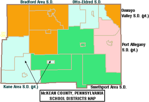
Public school districts
- Bradford Area School District
- Kane Area School District (Also covers part of Elk County)
- Otto-Eldred School District
- Port Allegany School District (Also covers part of Potter County)
- Smethport Area School District
- Oswayo Valley School District (Majority of which is in Potter County, covers small portion in McKean County)
Private schools
As reported by EdNA, Pennsylvania Department of Education, June 2010.
- Bradford Area Christian Academy, Bradford
- Chestnut Street Christian School, Bradford
- Custer City Private School
- St. Bernard School, Bradford
- Learning Center Inc, Bradford
- United Christian Academy, Smethport
Libraries
- Bradford Area Public Library
- Friends Memorial Public Library - Kane
- Hamlin Memorial Library - Smethport
- Mount Jewett Memorial Library
- Samuel W Smith Memorial Public Library - Port Allegany
Other education entities
- Beacon Light Behavioral Health Systems - Custer City
- Seneca Highlands Career and Technical Center - Port Allegany
- Seneca Highlands IU 9 - Smethport
- University of Pittsburgh at Bradford
- McKean County Historical Society's Museum at the Old Jail - Smethport
Recreation
There is one Pennsylvania state park in McKean County. Kinzua Bridge State Park is between U.S. Route 6 and Pennsylvania Route 59, just east of the Allegheny National Forest near Mount Jewett. When it was built, it was the highest and longest railroad bridge in the world. It was chosen by the Pennsylvania Department of Conservation and Natural Resources (DCNR) and its Bureau of Parks as one of "Twenty Must-See Pennsylvania State Parks" and is a Historic Civil Engineering Landmark. A tornado destroyed much of the bridge in 2003.
Communities
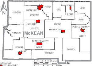
Under Pennsylvania law, there are four types of incorporated municipalities: cities, boroughs, townships, and, in at most two cases, towns. The following cities, boroughs and townships are located in McKean County:
City
Boroughs
- Eldred
- Kane
- Lewis Run
- Mount Jewett
- Port Allegany
- Smethport (county seat)
Townships
Census-designated places
Unincorporated communities
- Burning Well
- Coryville
- Cyclone
- Derrick City
- Farmers Valley
- Gifford
- Ludlow
Population ranking
The population ranking of the following table is based on the 2010 census of McKean County.[15]
† county seat
| Rank | City/Town/etc. | Municipal type | Population (2010 Census) |
|---|---|---|---|
| 1 | Bradford | City | 8,770 |
| 2 | Kane | Borough | 3,730 |
| 3 | Port Allegany | Borough | 2,157 |
| 4 | † Smethport | Borough | 1,655 |
| 5 | Foster Brook | CDP | 1,251 |
| 6 | Mount Jewett | Borough | 919 |
| 7 | Eldred | Borough | 875 |
| 8 | Lewis Run | Borough | 617 |
| 9 | Rew | CDP | 199 |
See also
- National Register of Historic Places listings in McKean County, Pennsylvania
References
- "State & County QuickFacts". United States Census Bureau. Archived from the original on June 6, 2011. Retrieved November 20, 2013.
- "Find a County". National Association of Counties. Archived from the original on May 31, 2011. Retrieved June 7, 2011.
- "Pennsylvania: Individual County Chronologies". Pennsylvania Atlas of Historical County Boundaries. The Newberry Library. 2008. Archived from the original on March 25, 2015. Retrieved March 13, 2015.
- Gannett, Henry (1905). The Origin of Certain Place Names in the United States. U.S. Government Printing Office. p. 194.
- "2010 Census Gazetteer Files". United States Census Bureau. August 22, 2012. Retrieved March 9, 2015.
- "U.S. Decennial Census". United States Census Bureau. Retrieved March 9, 2015.
- "Historical Census Browser". University of Virginia Library. Retrieved March 9, 2015.
- Forstall, Richard L., ed. (March 24, 1995). "Population of Counties by Decennial Census: 1900 to 1990". United States Census Bureau. Retrieved March 9, 2015.
- "Census 2000 PHC-T-4. Ranking Tables for Counties: 1990 and 2000" (PDF). United States Census Bureau. April 2, 2001. Archived (PDF) from the original on October 9, 2022. Retrieved March 9, 2015.
- "Census 2020".
- "U.S. Census website". United States Census Bureau. Retrieved January 31, 2008.
- "P2 HISPANIC OR LATINO, AND NOT HISPANIC OR LATINO BY RACE – 2020: DEC Redistricting Data (PL 94-171) – McKean County, Pennsylvania".
- "Office of Management and Budget - The White House". Retrieved November 27, 2018.
- "Businesses that Received Forms in 2012: Pennsylvania - U.S. Census Bureau". Archived from the original on September 24, 2015. Retrieved December 7, 2017.
- "2010 U.S. Census website". United States Census Bureau. Retrieved February 10, 2013.
- Leip, David. "Dave Leip's Atlas of U.S. Presidential Elections". uselectionatlas.org. Retrieved February 21, 2021.
- "Voter registration statistics by county". Dos.state.pa.us. Retrieved February 23, 2022.
- Center, Legislativate Data Processing. "Find Your Legislator". The official website for the Pennsylvania General Assembly. Retrieved May 11, 2017.
External links
- A resource website for families in McKean County including the McKean County Resource Directory
- McKean County Government
- McKean County Capitol History
- Bradford Today
- Bradford Era News
- Gardeau Train Wreck of 2006 - A website about the train wreck and chemical spill of June 30, 2006. Location: Gardeau, Norwich Township, McKean County, Pennsylvania
Municipalities and communities of McKean County, Pennsylvania, United States | ||
|---|---|---|
County seat: Smethport | ||
| City | 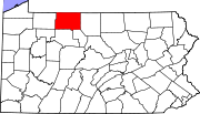 | |
| Boroughs | ||
| Townships | ||
| CDPs |
| |
| Unincorporated communities | ||
| ||
Authority control | |
|---|---|
| General | |
| National libraries | |
| Other |
|
На других языках
[de] McKean County
McKean County[1] ist ein County im Bundesstaat Pennsylvania der Vereinigten Staaten. Bei der Volkszählung im Jahr 2020 hatte das County 40.432 Einwohner und eine Bevölkerungsdichte von 18 Einwohner pro Quadratkilometer.[2] Der Verwaltungssitz (County Seat) ist Smethport.- [en] McKean County, Pennsylvania
[ru] Маккин (округ)
Округ Маккин (англ. McKean County) располагается в штате Пенсильвания, США. Официально образован 26-го марта 1804 года. По состоянию на 2010 год, численность населения составляла 43 450 человек.Другой контент может иметь иную лицензию. Перед использованием материалов сайта WikiSort.org внимательно изучите правила лицензирования конкретных элементов наполнения сайта.
WikiSort.org - проект по пересортировке и дополнению контента Википедии