world.wikisort.org - USA
Washington County is a county in the U.S. state of Pennsylvania. As of the 2010 census, the population was 207,820.[1] Its county seat is Washington.[2]
Washington County | |
|---|---|
U.S. county | |
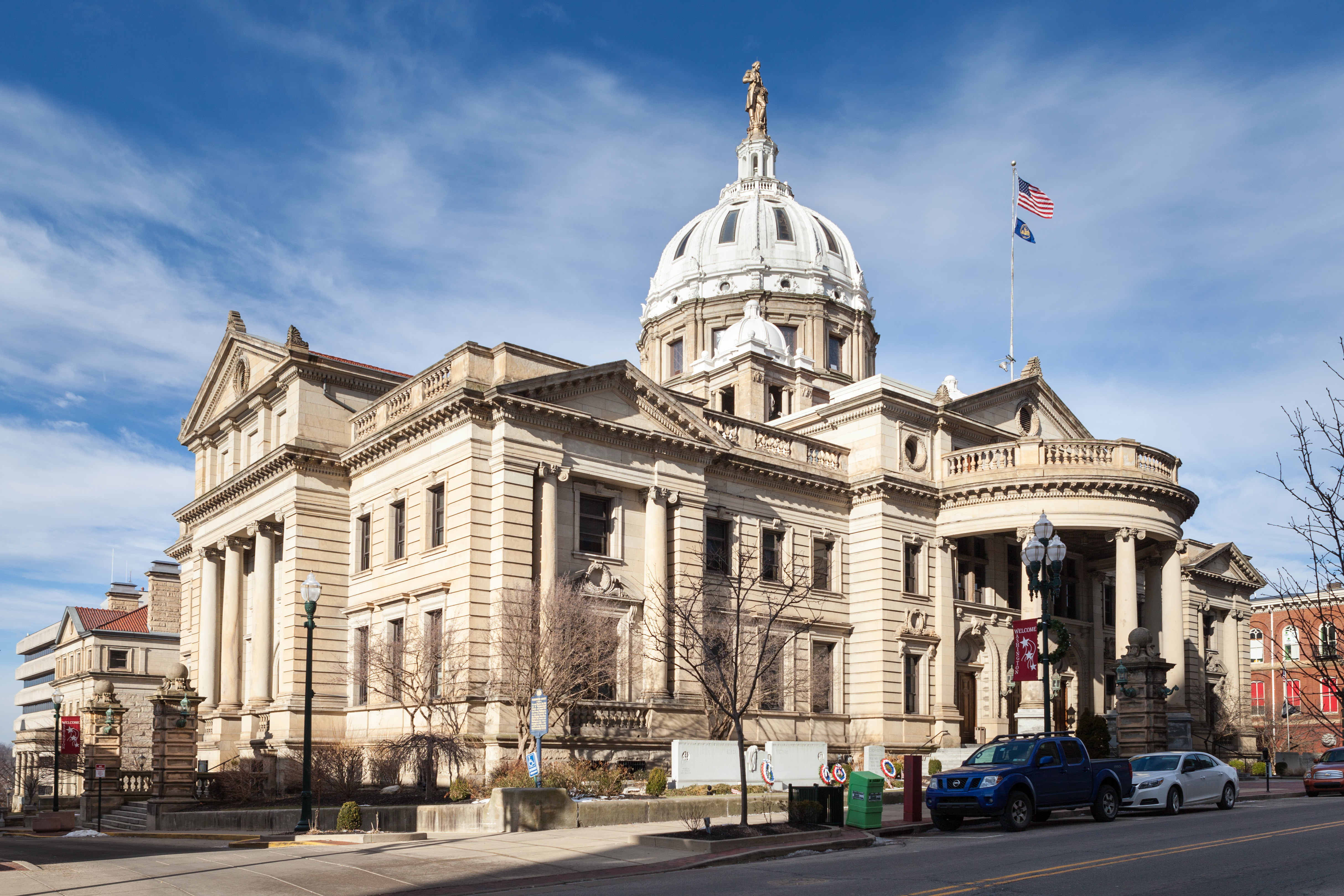 Washington County Courthouse | |
 Flag | |
 Location within the U.S. state of Pennsylvania | |
 Pennsylvania's location within the U.S. | |
| Coordinates: 40.19°N 80.25°W | |
| Country | |
| State | |
| Founded | March 28, 1781 |
| Named for | George Washington |
| Seat | Washington |
| Largest city | Peters Township |
| Area | |
| • Total | 861 sq mi (2,230 km2) |
| • Land | 857 sq mi (2,220 km2) |
| • Water | 3.9 sq mi (10 km2) 0.5%% |
| Population | |
| • Estimate (2019) | 206,865 |
| • Density | 243/sq mi (94/km2) |
| Time zone | UTC−5 (Eastern) |
| • Summer (DST) | UTC−4 (EDT) |
| Congressional district | 14th |
| Website | www |
Washington County is part of the Pittsburgh, PA Metropolitan Statistical Area.
The county is home to Washington County Airport, three miles (5 km) southwest of Washington.
History
The county was created on March 28, 1781, from part of Westmoreland County. The city and county were both named after American Revolutionary War leader George Washington, who eventually became the first President of the United States. The town of Charleroi got its name from the Belgian city of Charleroi. There lived many Belgian immigrants in the Monongahela area at the end of the 19th century, some of whom were glass makers.[3][4]
Geography
According to the U.S. Census Bureau, the county has a total area of 861 square miles (2,230 km2), of which 857 square miles (2,220 km2) is land and 3.9 square miles (10 km2) (0.5%) is water.[5]
Surrounding counties
- Beaver County (north)
- Allegheny County (NNE-northeast)
- Westmoreland County (East-northeast)
- Fayette County (East-southeast)
- Greene County (south)
- Marshall County, West Virginia (southwest)
- Ohio County, West Virginia (west)
- Brooke County, West Virginia (west)
- Hancock County, West Virginia (northwest)
Major highways
 I-70
I-70 I-79
I-79 US 19
US 19 US 22
US 22 US 40
US 40 PA 18
PA 18 PA Turnpike 43
 PA 50
PA 50 PA 88
PA 88 PA 88 Truck
 PA 136
 PA 221
 PA 231
 PA 331
 PA 481
 PA 519
 PA Turnpike 576
 PA 837
 PA 844
 PA 917
 PA 980
Climate
Washington County has a humid continental climate (Köppen Dfb), with warm summers and cold, snowy winters. Precipitation is highest in the summer months, with an annual average of 38.87 in (987 mm). Snow usually falls between November and April, with an average of 37.8 in (96 cm).
| Climate data for Washington, Pennsylvania (3mi NE) (1981–2010 normals, extremes 1975–present) | |||||||||||||
|---|---|---|---|---|---|---|---|---|---|---|---|---|---|
| Month | Jan | Feb | Mar | Apr | May | Jun | Jul | Aug | Sep | Oct | Nov | Dec | Year |
| Record high °F (°C) | 70 (21) |
75 (24) |
82 (28) |
90 (32) |
94 (34) |
93 (34) |
100 (38) |
96 (36) |
95 (35) |
87 (31) |
80 (27) |
76 (24) |
100 (38) |
| Average high °F (°C) | 35.1 (1.7) |
38.5 (3.6) |
48.5 (9.2) |
60.7 (15.9) |
69.4 (20.8) |
78.0 (25.6) |
81.6 (27.6) |
80.7 (27.1) |
73.9 (23.3) |
62.3 (16.8) |
51.0 (10.6) |
39.1 (3.9) |
59.6 (15.3) |
| Daily mean °F (°C) | 26.0 (−3.3) |
28.6 (−1.9) |
37.2 (2.9) |
48.6 (9.2) |
57.5 (14.2) |
66.2 (19.0) |
70.0 (21.1) |
69.0 (20.6) |
61.9 (16.6) |
50.6 (10.3) |
41.1 (5.1) |
30.5 (−0.8) |
48.9 (9.4) |
| Average low °F (°C) | 16.8 (−8.4) |
18.7 (−7.4) |
26.0 (−3.3) |
36.5 (2.5) |
45.6 (7.6) |
54.4 (12.4) |
58.5 (14.7) |
57.3 (14.1) |
49.9 (9.9) |
39.0 (3.9) |
31.1 (−0.5) |
21.8 (−5.7) |
38.0 (3.3) |
| Record low °F (°C) | −25 (−32) |
−20 (−29) |
−1 (−18) |
9 (−13) |
20 (−7) |
32 (0) |
38 (3) |
29 (−2) |
30 (−1) |
18 (−8) |
−4 (−20) |
−16 (−27) |
−25 (−32) |
| Average precipitation inches (mm) | 2.87 (73) |
2.47 (63) |
3.25 (83) |
3.11 (79) |
4.16 (106) |
3.91 (99) |
3.94 (100) |
3.19 (81) |
3.28 (83) |
2.46 (62) |
3.37 (86) |
2.97 (75) |
38.87 (987) |
| Average snowfall inches (cm) | 10.5 (27) |
9.3 (24) |
6.6 (17) |
1.2 (3.0) |
0 (0) |
0 (0) |
0 (0) |
0 (0) |
0 (0) |
0.2 (0.51) |
2.1 (5.3) |
7.9 (20) |
37.8 (96) |
| Average precipitation days (≥ 0.01 in) | 16 | 14 | 14 | 14 | 15 | 12 | 12 | 11 | 11 | 13 | 14 | 15 | 162 |
| Average snowy days (≥ 0.1 in) | 12 | 10 | 5 | 1 | 0 | 0 | 0 | 0 | 0 | 0 | 3 | 8 | 38 |
| Source: NOAA[6] | |||||||||||||
Demographics
| Historical population | |||
|---|---|---|---|
| Census | Pop. | %± | |
| 1790 | 23,892 | — | |
| 1800 | 28,298 | 18.4% | |
| 1810 | 36,289 | 28.2% | |
| 1820 | 40,038 | 10.3% | |
| 1830 | 42,784 | 6.9% | |
| 1840 | 41,279 | −3.5% | |
| 1850 | 44,939 | 8.9% | |
| 1860 | 46,805 | 4.2% | |
| 1870 | 48,483 | 3.6% | |
| 1880 | 55,418 | 14.3% | |
| 1890 | 71,155 | 28.4% | |
| 1900 | 92,181 | 29.5% | |
| 1910 | 143,680 | 55.9% | |
| 1920 | 188,992 | 31.5% | |
| 1930 | 204,802 | 8.4% | |
| 1940 | 210,852 | 3.0% | |
| 1950 | 209,628 | −0.6% | |
| 1960 | 217,271 | 3.6% | |
| 1970 | 210,876 | −2.9% | |
| 1980 | 217,074 | 2.9% | |
| 1990 | 204,584 | −5.8% | |
| 2000 | 202,897 | −0.8% | |
| 2010 | 207,820 | 2.4% | |
| 2020 | 209,349 | 0.7% | |
| U.S. Decennial Census[7] 1790–1960[8] 1900–1990[9] 1990–2000[10] 2010–2019[1] 2010-2020[11] | |||
As of the census[12] of 2000, there were 202,897 people, 81,130 households, and 56,060 families residing in the county. The population density was 237 people per square mile (91/km2). There were 87,267 housing units at an average density of 102 per square mile (39/km2). The racial makeup of the county was 95.27% White, 3.26% Black or African American, 0.09% Native American, 0.36% Asian, 0.02% Pacific Islander, 0.19% from other races, and 0.82% from two or more races. 0.58% of the population were Hispanic or Latino of any race. 18.3% were of German, 17.2% Italian, 10.6% Irish, 8.6% English, 7.9% Polish and 6.2% American ancestry.
There were 81,130 households, out of which 28.40% had children under the age of 18 living with them, 55.20% were married couples living together, 10.30% had a female householder with no husband present, and 30.90% were non-families. 27.00% of all households were made up of individuals, and 13.20% had someone living alone who was 65 years of age or older. The average household size was 2.44 and the average family size was 2.96.
In the county, the population was spread out, with 22.20% under the age of 18, 7.70% from 18 to 24, 27.20% from 25 to 44, 25.00% from 45 to 64, and 17.90% who were 65 years of age or older. The median age was 41 years. For every 100 females there were 92.40 males. For every 100 females age 18 and over, there were 89.00 males.
As of 1800, this county was largely settled by people of Scot-Irish heritage because "prime lands" were already taken by the Germans and the Quakers.
2020 Census
| Race | Num. | Perc. |
|---|---|---|
| White (NH) | 186,900 | 89.3% |
| Black or African American (NH) | 6,861 | 3.3% |
| Native American (NH) | 230 | 0.11% |
| Asian (NH) | 1,998 | 1% |
| Pacific Islander (NH) | 63 | 0.03% |
| Other/Mixed (NH) | 9,276 | 4.43% |
| Hispanic or Latino | 4,021 | 2% |
Government and politics

| Year | Republican | Democratic | Third party | |||
|---|---|---|---|---|---|---|
| No. | % | No. | % | No. | % | |
| 2020 | 72,080 | 60.70% | 45,088 | 37.97% | 1,588 | 1.34% |
| 2016 | 61,386 | 60.03% | 36,322 | 35.52% | 4,559 | 4.46% |
| 2012 | 53,230 | 56.04% | 40,345 | 42.48% | 1,403 | 1.48% |
| 2008 | 50,752 | 51.52% | 46,122 | 46.82% | 1,642 | 1.67% |
| 2004 | 47,673 | 49.57% | 48,225 | 50.14% | 279 | 0.29% |
| 2000 | 37,339 | 44.22% | 44,961 | 53.25% | 2,141 | 2.54% |
| 1996 | 27,777 | 35.73% | 40,952 | 52.67% | 9,016 | 11.60% |
| 1992 | 21,977 | 26.05% | 46,143 | 54.70% | 16,244 | 19.25% |
| 1988 | 28,651 | 37.43% | 47,527 | 62.08% | 375 | 0.49% |
| 1984 | 34,782 | 40.47% | 50,911 | 59.24% | 244 | 0.28% |
| 1980 | 32,532 | 39.66% | 45,295 | 55.23% | 4,191 | 5.11% |
| 1976 | 32,827 | 39.43% | 49,317 | 59.24% | 1,107 | 1.33% |
| 1972 | 42,587 | 54.00% | 34,781 | 44.10% | 1,494 | 1.89% |
| 1968 | 28,023 | 32.98% | 47,805 | 56.26% | 9,140 | 10.76% |
| 1964 | 24,127 | 27.49% | 63,482 | 72.34% | 147 | 0.17% |
| 1960 | 38,348 | 41.59% | 53,729 | 58.28% | 120 | 0.13% |
| 1956 | 39,465 | 45.04% | 48,052 | 54.84% | 98 | 0.11% |
| 1952 | 36,041 | 39.16% | 55,725 | 60.55% | 270 | 0.29% |
| 1948 | 26,860 | 35.73% | 46,327 | 61.63% | 1,979 | 2.63% |
| 1944 | 27,615 | 37.30% | 46,023 | 62.17% | 392 | 0.53% |
| 1940 | 29,026 | 36.21% | 50,829 | 63.42% | 296 | 0.37% |
| 1936 | 23,342 | 30.25% | 52,878 | 68.52% | 948 | 1.23% |
| 1932 | 21,447 | 40.82% | 28,934 | 55.07% | 2,155 | 4.10% |
| 1928 | 31,099 | 63.61% | 17,149 | 35.07% | 645 | 1.32% |
| 1924 | 22,315 | 60.64% | 6,706 | 18.22% | 7,776 | 21.13% |
| 1920 | 18,514 | 62.49% | 8,827 | 29.80% | 2,284 | 7.71% |
| 1916 | 10,367 | 52.39% | 7,747 | 39.15% | 1,674 | 8.46% |
| 1912 | 4,297 | 22.98% | 5,563 | 29.75% | 8,837 | 47.26% |
| 1908 | 11,430 | 56.31% | 7,018 | 34.57% | 1,850 | 9.11% |
| 1904 | 11,530 | 66.01% | 4,886 | 27.97% | 1,051 | 6.02% |
| 1900 | 10,408 | 59.40% | 6,380 | 36.41% | 733 | 4.18% |
| 1896 | 10,798 | 57.93% | 7,384 | 39.61% | 458 | 2.46% |
| 1892 | 8,060 | 51.24% | 6,847 | 43.53% | 822 | 5.23% |
| 1888 | 7,801 | 54.83% | 5,847 | 41.10% | 579 | 4.07% |
| 1884 | 6,699 | 50.21% | 5,849 | 43.84% | 793 | 5.94% |
| 1880 | 6,451 | 51.04% | 5,850 | 46.29% | 338 | 2.67% |
The County of Washington is governed by a three-member publicly elected commission. The three commissioners serve in both executive and legislative capacities. By state law, the commission must have a minority party guaranteeing a political split on the commission. Each term is for four years.
The three current commissioners for Washington County are Lawrence Maggi (Democrat), Diana Irey (Republican), and Nick Sherman (Republican).
Maggi was the Democratic nominee for Pennsylvania's 18th congressional district against Republican incumbent Tim Murphy in 2012. Maggi lost to Murphy and earned only 36 percent of the vote. Irey was the Republican candidate for Pennsylvania's 12th congressional district and lost to the late Democratic incumbent John Murtha in the 2006 election.
The Washington County Court of Common Pleas, the Twenty-Seventh Judicial District of Pennsylvania, is the state trial court, sitting in and for Washington County. It serves as the court of original jurisdiction for the region. There are five judges, which the county's citizens elect to ten year terms, under the laws of the Commonwealth. The President Judge is Katherine B. Emery; she is the most senior member of the bench. Judges of the court are:
- John F. DiSalle, P.J.
- Gary Gilman, J.
- Valarie Costanzo, J.
- Michael J. Lucas, J.
- Traci McDonald-Kemp, J.
- Jesse Pettit, J.
Additionally, magisterial district judges (MDJs) serve throughout the county to hear traffic citations, issue warrants, and decide minor civil matters.
The Democratic Party has been historically dominant in county-level politics and national politics, only voting Republican for president in Richard Nixon's 1972 landslide victory over George McGovern between 1928 & 2008. However, like much of Appalachian coal country, Washington has trended strongly Republican in recent years. In 2000, Democrat Al Gore won 53% of the vote and Republican George W. Bush won 44%. In 2004, Democrat John Kerry received 50.14% of the vote and Bush received 49.57% a difference of 552 votes. In 2008, Republican John McCain won 51% to Democrat Barack Obama's 46% and each of the three state row office winners carried Washington County.
Voter registration
As of November 7, 2022, there are 144,520 registered voters in the county. Registered Republicans have a plurality of 67,881 registered voters, compared to 58,613 registered Democrats, 13,861 registered non-affiliated voters, and 4,165 voters registered to other parties.[15]
Chart of Voter Registration
| Voter registration and party enrollment | |||||
|---|---|---|---|---|---|
| Party | Number of voters | Percentage | |||
| Republican | 67,881 | 46.97 | |||
| Democratic | 58,613 | 40.56 | |||
| Independent | 13,861 | 9.59 | |||
| Third Party | 4,165 | 2.88 | |||
| Total | 144,520 | 100% | |||
County row offices
- Clerk of Courts, Brenda Davis, Republican
- Controller, April Sloane, Republican
- Coroner, Timothy Warco, Democrat
- District Attorney, Jason Walsh, Republican
- Prothonotary, Laura Hough, Republican
- Recorder of Deeds, Carrie Perrell, Republican
- Register of Wills, James Roman, Republican
- Sheriff, Anthony Andronas, Republican
- Treasurer, Tom Flickinger, Republican
- Public Safety Director, Jeffrey A. Yates, Independent
State representatives
- Josh Kail, Republican, 15th district
- Mike Puskaric, Republican, 39th district
- Natalie Mihalek, Republican, 40th district
- Jason Ortitay, Republican, 46th district
- Tim O'Neal, Republican, 48th district
- Bud Cook, Republican, 49th district
- Pam Snyder, Democrat, 50th district
State senators
- Devlin Robinson, Republican, 37th district (Peters Township)
- Camera Bartolotta, Republican, 46th district
United States Representatives
- Guy Reschenthaler, Republican, 14th district
United States Senators
- Pat Toomey, Republican
- Bob Casey, Jr., Democrat
Landmarks and events

Pony League baseball was founded in Washington County in 1951 for 13 and 14 year old boys and its headquarters are located here. As of 2016, more than a half-million youth in the U.S. and 40 other nations participate. The televised Pony League World Series held annually in August at Washington's Lew Hays Pony Field attracts teenage teams from around the world.[16]
Washington County is also the home of the Pennsylvania Trolley Museum.[17] Washington County is also famous for its Rock Shelters at Meadowcroft Village, which are one of the best preserved and oldest Pre-Clovis Native American dwellings in the country.[18] The county has 21 covered bridges still standing.[19]
The Whiskey Rebellion culminated in Washington. The home of David Bradford, one of the rebellion leaders, is located in Washington and is a national landmark.[20] Just a couple blocks away is the F. Julius LeMoyne House, which serves as the headquarters of the Washington County Historical Society.
Washington County is the home of the first crematory in the United States.[21][22]
In 1981, the Pennsylvania Historical and Museum Commission installed a historical marker noting the historic importance of the county.[23]
Education
Colleges and universities
- California University of Pennsylvania in California Borough
- Community College of Allegheny County Washington branch in North Franklin Township
- Washington & Jefferson College in the City of Washington and East Washington Borough
- Waynesburg University- Southpointe Center Campus in Cecil Township.[24]
Public school districts
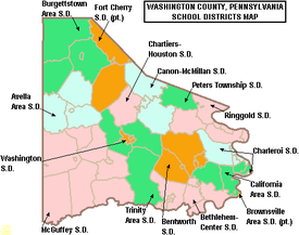
- Avella Area School District
- Bentworth School District
- Bethlehem-Center School District
- Brownsville Area School District (also in Fayette County)
- Burgettstown Area School District
- California Area School District
- Canon-McMillan School District
- Charleroi School District
- Chartiers-Houston School District
- Fort Cherry School District (also in Allegheny County)
- McGuffey School District
- Peters Township School District
- Ringgold School District
- Trinity Area School District
- Washington School District
- Served by
- Intermediate Unit 1 – Coal Center
- Mon Valley Career and Technology Center – Charleroi
- Western Area Career and Technology Center – Canonsburg
Private schools
- Calvary Chapel Christian School – Fredericktown
- Central Christian Academy – Houston
- Children's School of Washington
- Cornerstone Mennonite School – Burgettstown
- Faith Christian School of Washington – Washington
- First Love Christian Academy High – Washington
- Goddard School – Venetia
- Gwens Montessori School Inc – Washington
- Hickory Christian School – Hickory
- Huntington Learning Center – McMurray
- John F Kennedy School – Washington
- Kinder Care Learning Centers
- Lakeview Christian Academy – Bridgeville
- Madonna Catholic Regional School – Monongahela
- Mel Blount Leadership Academy – Claysville
- NHS School – Ellsworth
- Rainbows End Learning Center – Washington
- St Francis Children's School – Beallsville
- Tri-State Christian School – Burgettstown
Libraries

- Avella Area Library Center
- Bentleyville Public Library
- Burgettstown Community Library
- California Public Library
- Chartiers-Houston Community Library
- Citizens Library – Washington
- Donora Public Library
- Frank Sarris Public Library – Canonsburg
- Fredericktown Area Public Library
- Heritage Public Library – McDonald
- John K Tener Library – Charleroi
- Marianna Community Public Library
- Monongahela Area Library
- Peters Township Public Library
- Washington County Library System
Hospitals
- Canonsburg General Hospital, part of West Penn Allegheny Health System in North Strabane Township
- Monongahela Valley Hospital in Carroll Township
- The Washington Hospital in the City of Washington
Communities
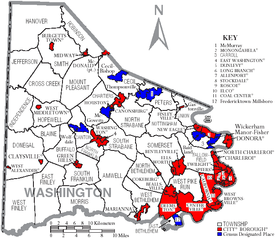
Under Pennsylvania law, there are four types of incorporated municipalities: cities, boroughs, townships, and, in at most two cases, towns. The following cities, boroughs and townships are located in Washington County:
Cities
- Monongahela
- Washington (county seat)
Boroughs
- Allenport
- Beallsville
- Bentleyville
- Burgettstown
- California
- Canonsburg
- Centerville
- Charleroi
- Claysville
- Coal Center
- Cokeburg
- Deemston
- Donora
- Dunlevy
- East Washington
- Elco
- Ellsworth
- Finleyville
- Green Hills
- Houston
- Long Branch
- Marianna
- McDonald (partly in Allegheny County)
- Midway
- New Eagle
- North Charleroi
- Roscoe
- Speers
- Stockdale
- Twilight
- West Brownsville
- West Middletown
Townships
- Amwell
- Blaine
- Buffalo
- Canton
- Carroll
- Cecil
- Chartiers
- Cross Creek
- Donegal
- East Bethlehem
- East Finley
- Fallowfield
- Hanover
- Hopewell
- Independence
- Jefferson
- Morris
- Mount Pleasant
- North Bethlehem
- North Franklin
- North Strabane
- Nottingham
- Peters
- Robinson
- Smith
- Somerset
- South Franklin
- South Strabane
- Union
- West Bethlehem
- West Finley
- West Pike Run
Census-designated places
Census-designated places are geographical areas designated by the U.S. Census Bureau for the purposes of compiling demographic data. They are not actual jurisdictions under Pennsylvania law.
- Aaronsburg
- Atlasburg
- Avella
- Baidland
- Bulger
- Cecil-Bishop
- Cross Creek
- Eighty Four
- Elrama
- Fredericktown
- Gastonville
- Hendersonville
- Hickory
- Joffre
- Langeloth
- Lawrence
- McGovern
- McMurray
- Meadowlands
- Millsboro
- Muse
- Paris
- Slovan
- Southview
- Taylorstown
- Thompsonville
- Van Voorhis
- West Alexander
- Westland
- Wickerham Manor-Fisher
- Wolfdale
- Wylandville
Unincorporated communities
- Amity
- Blainsburg
- Condit Crossing
- Cool Valley
- Courtney
- Cracker Jack
- Daisytown
- Fallowfield
- Florence
- Frogtown
- Gambles
- Glyde
- Good Intent
- Hazel Kirk
- Laboratory
- Log Pile
- Lover
- Manifold
- Murdocksville
- McAdams
- North Fredericktown
- Old Concord
- P and W Patch
- Prosperity
- Raccoon
- Richeyville
- Scenery Hill
- Studa
- Venetia
- Vestaburg
Former communities
- Allen Township[25]
- Bethlehem Township
- East Pike Run Township
- Granville
- Pike Run
- Pike Run Township
- Smallwood
- South Canonsburg (annexed to Canonsburg in 1911)
Population ranking
The population ranking of the following table is based on the 2010 census of Washington County.[26]
† county seat
| Rank | City/Town/etc. | Municipal type | Population (2010 Census) |
|---|---|---|---|
| 1 | † Washington | City | 13,663 |
| 2 | Canonsburg | Borough | 8,992 |
| 3 | California | Borough | 6,795 |
| 4 | Donora | Borough | 4,781 |
| 5 | McMurray | CDP | 4,647 |
| 6 | Monongahela | City | 4,300 |
| 7 | Charleroi | Borough | 4,120 |
| 8 | Thompsonville | CDP | 3,520 |
| 9 | Centerville | Borough | 3,263 |
| 10 | Wolfdale | CDP | 2,888 |
| 11 | Gastonville | CDP | 2,818 |
| 12 | McGovern | CDP | 2,742 |
| 13 | Bentleyville | Borough | 2,581 |
| 14 | Muse | CDP | 2,504 |
| 15 | Cecil-Bishop | CDP | 2,476 |
| 16 | East Washington | Borough | 2,234 |
| 17 | New Eagle | Borough | 2,184 |
| 18 | McDonald (partially in Allegheny County) | Borough | 2,149 |
| 19 | Wickerham Manor-Fisher | CDP | 1,728 |
| 20 | Baidland | CDP | 1,563 |
| 21 | Burgettstown | Borough | 1,388 |
| 22 | North Charleroi | Borough | 1,313 |
| 23 | Houston | Borough | 1,296 |
| 24 | Speers | Borough | 1,154 |
| 25 | Ellsworth | Borough | 1,027 |
| 26 | West Brownsville | Borough | 992 |
| 27 | Midway | Borough | 913 |
| 28 | Claysville | Borough | 829 |
| 29 | Meadowlands | CDP | 822 |
| 30 | Roscoe | Borough | 812 |
| 31 | Avella | CDP | 804 |
| 32 | Hickory | CDP | 740 |
| 33 | Paris | CDP | 732 |
| 34 | Deemston | Borough | 722 |
| 35 | Langeloth | CDP | 717 |
| 36 | Millsboro | CDP | 666 |
| 37 | Eighty Four | CDP | 657 |
| 38 | Cokeburg | Borough | 630 |
| 39 | West Alexander | CDP | 604 |
| 40 | Slovan | CDP | 555 |
| 41 | Lawrence | CDP | 540 |
| 42 | Allenport | Borough | 537 |
| 43 | Joffre | CDP | 536 |
| 44 | Stockdale | Borough | 502 |
| 45 | Marianna | Borough | 494 |
| 46 | Beallsville | Borough | 466 |
| 47 | Finleyville | Borough | 461 |
| 48 | Long Branch | Borough | 447 |
| 49 | Bulger | CDP | 407 |
| 50 | Fredericktown | CDP | 403 |
| 51 | Atlasburg | CDP | 401 |
| 52 | Wylandville | CDP | 391 |
| 53 | Dunlevy | Borough | 381 |
| 54 | Hendersonville | CDP | 325 |
| 55 | Elco | Borough | 323 |
| 56 | Elrama | CDP | 307 |
| 57 | Southview | CDP | 276 |
| 58 | Aaronsburg | CDP | 259 |
| 59 | Twilight | Borough | 233 |
| 60 | Taylorstown | CDP | 217 |
| 61 | Westland | CDP | 167 |
| 62 | Van Voorhis | CDP | 166 |
| T-63 | Coal Center | Borough | 139 |
| T-63 | West Middletown | Borough | 139 |
| 64 | Cross Creek | CDP | 137 |
| 65 | Green Hills | Borough | 29 |
Notable people
- John Alexander Anderson, born in Washington County, United States Congressman from Kansas[27]
- Jonathan Arnold, brother-in-law of Gen. Stonewall Jackson.
- Kurt Angle (born 1968), resided in Canonsburg, Olympic gold medalist and Professional wrestler
- James G. Blaine (1830–1893), native of West Brownsville, United States Secretary of State, Speaker of the House of Representatives, and 1884 Republican presidential nominee
- David Bradford, born in Maryland 1760 and resided in Washington, early deputy attorney-general for Washington County, became a leader in the Whiskey Rebellion challenging the nascent United States federal government[28]
- Alexander G. Clark (1826–1891), born in Washington County, "The Colored Orator of the West", Minister to Liberia 1890–1891[29][30]
- William J. Carson (1840–1913), Civil War Medal of Honor recipient, 1863[31][32]
- Perry Como (1912–2001), native of Canonsburg, recording artist and television performer
- Mitch Daniels (born 1949), native of Monongahela, former Governor of Indiana, current president of Purdue University
- iJustine (born 1984), YouTube personality and actress
- Alexander Fulton (unknown-died ca. 1818), founder of Alexandria, Louisiana[33]
- Ken Griffey Jr. (born 1969), native of Donora, Major League Baseball player
- Ken Griffey Sr. (born 1950), native of Donora, Major League Baseball player
- John Guzik (1936–2012), football player
- Joseph Hardy (born 1924), former resident of Eighty Four, philanthropist, former CEO and founder of 84 Lumber
- Pete Henry (1897–1952), NFL player/coach, member of Pro Football Hall of Fame.
- Shirley Jones (born 1934), native of Charleroi, best known for her role as the mother of the Partridge Family and winning an Academy Award.
- Francis Julius LeMoyne (1798–1879) abolitionist and pioneer of cremation in the United States.
- Jonathan Letterman (1824–1872), native of Canonsburg, Father of Battlefield Medicine and Civil War surgeon
- William Henry Letterman (1832–1881), native of Canonsburg, co-founder of the Phi Kappa Psi fraternity, surgeon, and brother of Jonathan Letterman
- Marvin Lewis (born 1958), native of McDonald, National Football League player, coach
- Jay Livingston (1915–2001), native of McDonald, Oscar-winning songwriter
- William Holmes McGuffey (1800–1873), native of the western side of the county, famous educator and writer of McGuffey's Eclectic Readers – one of America's first text books
- John F. McJunkin (1830–1883), Iowa Attorney General
- John H. Mitchell (1835–1905), United States Senator, participant in original dispute in landmark Supreme Court case Pennoyer v. Neff
- Joe Montana (born 1956), native of Monongahela, National Football League player
- Stan Musial (1920–2013), native of Donora, Major League Baseball player
- Deborah Jeane Palfrey (1956–2008), native of Charleroi, "The D.C. Madam"
- John Walker Rankin (1823–1869), Iowa state senator
- David Redick (died 1805), Vice-President (Lt. Governor) of Pennsylvania for three weeks in 1788; surveyor—laid out the town of Washington.
- Kurt Schottenheimer (born 1949), native of McDonald, National Football League coach
- Marty Schottenheimer (1943–2021), native of McDonald, National Football League player, coach
- Paul Shannon (1909–1990), radio and television personality
- Bobby Vinton (born 1935), native of Canonsburg, recording artist
- Bob West (born 1956), native of Finleyville, voice actor best known for Barney & Friends
- Joseph Ruggles Wilson (1822–1903), graduate of Jefferson College (subsequently W&J), Presbyterian minister, father of Pres. Woodrow Wilson
- Bud Yorkin (1926–2015), American film and television producer, director, writer and actor.
- Christopher Rankin (1788-1826), member of the U.S. House of Representatives for Mississippi's at-large district, namesake of Rankin County
See also
- National Register of Historic Places listings in Washington County, Pennsylvania
References
- "State & County QuickFacts". United States Census Bureau. Archived from the original on August 13, 2011. Retrieved November 22, 2013.
- "Find a County". National Association of Counties. Archived from the original on May 31, 2011. Retrieved June 7, 2011.
- Pennsylvania Heritage, Volumes 34-36 - Pennsylvania Historical and Museum Commission, 2008. Pg. 5
- "Pennsylvania Heritage". Pennsylvania Historical and Museum Commission. April 9, 2008 – via Google Books.
- "2010 Census Gazetteer Files". United States Census Bureau. August 22, 2012. Retrieved March 11, 2015.
- "NowData - NOAA Online Weather Data". National Oceanic and Atmospheric Administration. Retrieved January 13, 2020.
- "U.S. Decennial Census". United States Census Bureau. Retrieved March 11, 2015.
- "Historical Census Browser". University of Virginia Library. Retrieved March 11, 2015.
- Forstall, Richard L., ed. (March 24, 1995). "Population of Counties by Decennial Census: 1900 to 1990". United States Census Bureau. Retrieved March 11, 2015.
- "Census 2000 PHC-T-4. Ranking Tables for Counties: 1990 and 2000" (PDF). United States Census Bureau. April 2, 2001. Archived (PDF) from the original on October 9, 2022. Retrieved March 11, 2015.
- "Census 2020".
- "U.S. Census website". United States Census Bureau. Retrieved May 14, 2011.
- "P2 HISPANIC OR LATINO, AND NOT HISPANIC OR LATINO BY RACE – 2020: DEC Redistricting Data (PL 94-171) – Washington County, Pennsylvania".
- Leip, David. "Dave Leip's Atlas of U.S. Presidential Elections". uselectionatlas.org. Retrieved November 29, 2018.
- "Voter registration statistics by county". www.dos.pa.gov. November 7, 2022. Retrieved November 7, 2022.
- Crawley, Dave. "Teens Flock To Play Ball In Pony League World Series (August 5, 2016)". KDKA-TV. Retrieved August 16, 2017.
- Archived December 10, 2008, at the Wayback Machine
- Archived July 17, 2008, at the Wayback Machine
- "Welcome to Washington County, Pennsylvania". Archived from the original on October 25, 2008. Retrieved October 25, 2008.
- Welcome! Archived 2008-12-28 at the Wayback Machine. Bradfordhouse.org. Retrieved on 2013-07-23.
- "The LeMoyne Crematory". Archived from the original on July 10, 2009. Retrieved March 7, 2009.
- "An Unceremonious Rite; Cremation of Mrs. Ben Pitman" (PDF). New York Times. February 16, 1879. Archived (PDF) from the original on October 9, 2022. Retrieved March 7, 2009.
- "Mingo Creek Church – PHMC Historical Markers". Historical Marker Database. Pennsylvania Historical & Museum Commission. Archived from the original on December 7, 2013. Retrieved December 9, 2013.
- "Homepage". www.waynesburg.edu. Archived from the original on April 2, 2015.
- "Allen Township, Washington County, PA". freepages.genealogy.rootsweb.ancestry.com. Retrieved November 29, 2018.
- CNMP, US Census Bureau. "This site has been redesigned and relocated. - U.S. Census Bureau". www.census.gov. Retrieved November 29, 2018.
- Who Was Who in America, Historical Volume, 1607–1896. Marquis Who's Who. 1967.
- Welcome!. Bradfordhouse.org. Retrieved on 2013-07-23.
- Alexander Clark of Muscatine, Iowa | HOME. Alexanderclark.org. Retrieved on 2013-07-23.
- [dead link]
- History, U.S. Army Center of Military. "Medal of Honor Recipients - Civil War (A-L)". www.history.army.mil. Archived from the original on August 2, 2008. Retrieved November 29, 2018.
- "CMOHS.org - Musician CARSON, WILLIAM J., U.S. Army". www.cmohs.org. Retrieved November 29, 2018.
- "Fulton, Alexander". lahistory.org (Louisiana Historical Association). Archived from the original on September 23, 2010. Retrieved October 9, 2010.
External links
- Washington County Web Site
- History & Genealogy in Washington County, PA
- History of Townships in Washington County, PA
- History of Washington County, Pennsylvania
- Citizens of Washington County (Deaths and Obituaries)
Places adjacent to Washington County, Pennsylvania | |
|---|---|

Pittsburgh–New Castle–Weirton combined statistical area | ||
| Counties |  | |
| Major cities | ||
| Cities and towns 15k–50k (in 2010) | ||
| Airports | ||
| Topics |
| |
| ||
Authority control | |
|---|---|
| General | |
| National libraries | |
| Other |
|
На других языках
[de] Washington County (Pennsylvania)
Das Washington County[3] ist ein County im US-Bundesstaat Pennsylvania. Bei der Volkszählung im Jahr 2020 hatte das County 209.349 Einwohner und eine Bevölkerungsdichte von 94,3 Einwohnern pro Quadratkilometer.[4] Der Verwaltungssitz (County Seat) ist Washington.[5]- [en] Washington County, Pennsylvania
[ru] Вашингтон (округ, Пенсильвания)
Вашингтон (англ. Washington County) — округ в США, штате Пенсильвания. Официально образован 28 марта 1781 года. По состоянию на 2010 год, численность населения составляла 207 820 человек. Получил своё название по имени первого президента США Джорджа Вашингтона.Другой контент может иметь иную лицензию. Перед использованием материалов сайта WikiSort.org внимательно изучите правила лицензирования конкретных элементов наполнения сайта.
WikiSort.org - проект по пересортировке и дополнению контента Википедии