world.wikisort.org - USA
Greene County is a county in the Commonwealth of Pennsylvania. As of the 2010 census, the population was 38,686.[1] Its county seat is Waynesburg.[2] Greene County was created on February 9, 1796, from part of Washington County and named for General Nathanael Greene.
This article needs additional citations for verification. (March 2022) |
Greene County | |
|---|---|
U.S. county | |
 Greene County Courthouse | |
 Seal | |
 Location within the U.S. state of Pennsylvania | |
 Pennsylvania's location within the U.S. | |
| Coordinates: 39°52′N 80°13′W | |
| Country | |
| State | |
| Founded | February 9, 1796 |
| Named for | Nathanael Greene |
| Seat | Waynesburg |
| Largest borough | Waynesburg |
| Area | |
| • Total | 578 sq mi (1,500 km2) |
| • Land | 576 sq mi (1,490 km2) |
| • Water | 2.0 sq mi (5 km2) 0.4%% |
| Population | |
| • Estimate (2018) | 36,506 |
| • Density | 65/sq mi (25/km2) |
| Time zone | UTC−5 (Eastern) |
| • Summer (DST) | UTC−4 (EDT) |
| Congressional district | 14th |
| Website | www |
Greene County is part of the Pittsburgh media market. It is in the area of southwestern Pennsylvania that was claimed by Virginia, the District of West Augusta.
Geography
According to the U.S. Census Bureau, the county has a total area of 578 square miles (1,500 km2), of which 576 square miles (1,490 km2) is land and 2.0 square miles (5.2 km2) (0.4%) is water.[3] It has a humid continental climate (Dfa/Dfb) and average monthly temperatures in Waynesburg range from 28.9 °F in January to 71.9 °F in July.
Adjacent counties
- Washington County (north)
- Fayette County (east)
- Monongalia County, West Virginia (south)
- Wetzel County, West Virginia (southwest)
- Marshall County, West Virginia (west)
Demographics
| Historical population | |||
|---|---|---|---|
| Census | Pop. | %± | |
| 1800 | 8,605 | — | |
| 1810 | 12,544 | 45.8% | |
| 1820 | 15,554 | 24.0% | |
| 1830 | 18,028 | 15.9% | |
| 1840 | 19,147 | 6.2% | |
| 1850 | 22,136 | 15.6% | |
| 1860 | 24,343 | 10.0% | |
| 1870 | 25,887 | 6.3% | |
| 1880 | 28,273 | 9.2% | |
| 1890 | 28,935 | 2.3% | |
| 1900 | 28,281 | −2.3% | |
| 1910 | 28,882 | 2.1% | |
| 1920 | 30,804 | 6.7% | |
| 1930 | 41,767 | 35.6% | |
| 1940 | 44,671 | 7.0% | |
| 1950 | 45,394 | 1.6% | |
| 1960 | 39,457 | −13.1% | |
| 1970 | 39,108 | −0.9% | |
| 1980 | 42,253 | 8.0% | |
| 1990 | 44,164 | 4.5% | |
| 2000 | 40,672 | −7.9% | |
| 2010 | 38,686 | −4.9% | |
| 2020 | 35,954 | −7.1% | |
| [4] | |||
As of the census[5] of 2010, there were 38,686 people, 14,724 households, and 9,970 families residing in the county. The population density was 67 people per square mile (25.9/km2). There were 16,678 housing units at an average density of 29 per square mile (11/km2). The racial makeup of the county was 94.6 percent White, 3.3 percent Black or African American, 0.2% Native American, 0.3 percent Asian, 0.0 percent Pacific Islander, 0.7 percent from other races, and 1.0% from two or more races. 1.2 percent of the population were Hispanic or Latino of any race.
There were 14,724 households, out of which 29.3 percent had children under the age of 18 living with them, 51.5 percent were married couples living together, 10.9 percent had a female householder with no husband present, and 32.3 percent were non-families. 27.0 percent of all households were made up of individuals, and 11.7 percent had someone living alone who was 65 years of age or older. The average household size was 2.42 and the average family size was 2.91.
In the county, the population was spread out, with 19.9 percent under the age of 18, 9.9 percent from 18 to 24, 25.5 percent from 25 to 44, 29.3 percent from 45 to 64, and 15.3 percent who were 65 years of age or older. The median age was 41.1 years. For every 100 females there were 106.2 males. For every 100 females age 18 and over, there were 105.6 males.
2020 Census
| Race | Num. | Perc. |
|---|---|---|
| White (NH) | 32,898 | 91.5% |
| Black or African American (NH) | 1,062 | 3% |
| Native American (NH) | 69 | 0.2% |
| Asian (NH) | 120 | 0.33% |
| Pacific Islander (NH) | 6 | 0.02% |
| Other/Mixed (NH) | 1,289 | 3.6% |
| Hispanic or Latino | 510 | 1.42% |
Government and politics
Greene County was long a Democratic stronghold, due to the strong unionization of the county's steel mills; between 1932 and 2000, the Democratic presidential candidate won the county in every election except in the Republican landslide of 1972. Due to the decline of the Pittsburgh area's steel industry (similar to other Appalachian counties), and the Democratic Party's shift on cultural issues like the environment and guns, the county has shifted towards the Republican Party, and in 2016 Donald Trump won the county with 68.4% of the vote.
| Year | Republican | Democratic | Third party | |||
|---|---|---|---|---|---|---|
| No. | % | No. | % | No. | % | |
| 2020 | 12,579 | 71.08% | 4,911 | 27.75% | 207 | 1.17% |
| 2016 | 10,849 | 68.37% | 4,482 | 28.25% | 537 | 3.38% |
| 2012 | 8,428 | 57.94% | 5,852 | 40.23% | 266 | 1.83% |
| 2008 | 7,889 | 48.96% | 7,829 | 48.59% | 396 | 2.46% |
| 2004 | 7,786 | 50.02% | 7,674 | 49.30% | 105 | 0.67% |
| 2000 | 5,890 | 43.14% | 7,230 | 52.96% | 533 | 3.90% |
| 1996 | 4,002 | 29.14% | 7,620 | 55.47% | 2,114 | 15.39% |
| 1992 | 3,482 | 23.01% | 8,438 | 55.75% | 3,215 | 21.24% |
| 1988 | 4,879 | 34.62% | 9,126 | 64.75% | 90 | 0.64% |
| 1984 | 6,376 | 40.40% | 9,365 | 59.33% | 43 | 0.27% |
| 1980 | 5,336 | 37.79% | 8,193 | 58.02% | 592 | 4.19% |
| 1976 | 5,293 | 37.22% | 8,769 | 61.67% | 157 | 1.10% |
| 1972 | 7,790 | 57.52% | 5,562 | 41.07% | 191 | 1.41% |
| 1968 | 5,099 | 35.41% | 8,198 | 56.93% | 1,104 | 7.67% |
| 1964 | 3,896 | 25.42% | 11,412 | 74.46% | 19 | 0.12% |
| 1960 | 7,498 | 43.70% | 9,645 | 56.21% | 16 | 0.09% |
| 1956 | 7,562 | 43.45% | 9,827 | 56.47% | 14 | 0.08% |
| 1952 | 6,964 | 40.68% | 10,125 | 59.14% | 30 | 0.18% |
| 1948 | 4,717 | 36.47% | 8,015 | 61.97% | 202 | 1.56% |
| 1944 | 5,747 | 40.49% | 8,392 | 59.13% | 53 | 0.37% |
| 1940 | 6,726 | 39.62% | 10,214 | 60.17% | 36 | 0.21% |
| 1936 | 6,359 | 34.42% | 12,006 | 64.99% | 109 | 0.59% |
| 1932 | 4,808 | 33.42% | 9,322 | 64.79% | 258 | 1.79% |
| 1928 | 6,910 | 56.18% | 5,293 | 43.04% | 96 | 0.78% |
| 1924 | 4,590 | 41.82% | 5,874 | 53.52% | 512 | 4.66% |
| 1920 | 4,253 | 42.41% | 5,592 | 55.76% | 183 | 1.82% |
| 1916 | 2,096 | 33.93% | 3,930 | 63.62% | 151 | 2.44% |
| 1912 | 1,150 | 19.00% | 3,551 | 58.67% | 1,351 | 22.32% |
| 1908 | 2,438 | 37.22% | 3,793 | 57.91% | 319 | 4.87% |
| 1904 | 2,442 | 41.32% | 3,198 | 54.11% | 270 | 4.57% |
| 1900 | 2,427 | 39.02% | 3,674 | 59.07% | 119 | 1.91% |
| 1896 | 2,453 | 36.41% | 4,198 | 62.31% | 86 | 1.28% |
| 1892 | 2,126 | 33.39% | 3,977 | 62.46% | 264 | 4.15% |
| 1888 | 2,373 | 35.79% | 4,116 | 62.08% | 141 | 2.13% |
Voter registration
As of November 1, 2021, there are 22,005 registered voters in the county. The number of registered Republicans outnumbers the number of registered Democrats by a margin of 1,052 voters (4.78%); there are 10,462 registered Republicans, 9,410 registered Democrats, 1,433 voters registered non-affiliated voters, and 700 voters registered to other parties.[8]
Chart of Voter Registration
| Voter registration and party enrollment | |||||
|---|---|---|---|---|---|
| Party | Number of voters | Percentage | |||
| Republican | 10,462 | 47.54 | |||
| Democratic | 9,410 | 42.76 | |||
| Independent | 1,433 | 6.51 | |||
| Third Parties | 700 | 3.18 | |||
| Total | 22,005 | 100% | |||
County commissioners
- Mike Belding, Republican[9]
- Betsy McClure, Republican
- Blair Zimmerman, Democrat
Other county officials
- President Judge, Hon. Louis Dayich
- Associate Judge, Hon. Jeffry N. Grimes [10]
- District Attorney, David Russo, Republican
- Sheriff, Marcus Simms, Democrat
- Coroner, Gene Rush, Republican
- Clerk of Courts, Sherry Wise, Democrat
- Prothonotary, Susan White, Democrat
- Recorder of Deeds and Register of Wills, Donna Tharp, Democrat
- Treasurer, Cory Grandel, Democrat
- Controller, Ami Cree, Democrat
State Representative
- Pam Snyder, Democrat, 50th district[11]
State Senator
- Camera Bartolotta, Republican, 46th district[11]
US Representative
- Guy Reschenthaler, Republican, 14th district
United States Senate
- Pat Toomey, Republican
- Bob Casey, Jr., Democrat
Economy
This section needs expansion. You can help by adding to it. (July 2016) |
Greene County's development commission has assisted area business since 1998.[12]
The Meadow Ridge office park has served the county since the early 2000s.[13]
Two power plant construction projects are underway in Greene County. Hill Top Energy Center, a natural gas-fired power plant with a generating capacity of 625 megawatts, is scheduled to begin operations in the summer of 2021.[14][15] A new 1,000-megawatt natural gas power plant on the site of the former Hatfield's Ferry power station is scheduled to begin operations in mid-2022.[16][17][18][19]
Education
Colleges and universities
- Waynesburg University
Public school districts
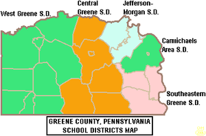
Greene County is divided into five public school districts.[20][21] There are 15 public schools that serve Greene County, Pennsylvania.[22]
- Carmichaels Area School District
- Central Greene School District
- Jefferson-Morgan School District
- Southeastern Greene School District
- West Greene School District
Some schools within the five above districts include:
Private schools
- Open Door Christian School in Waynesburg (grades K-12) [23][24]
- Greene Valley Christian Academy in Rices Landing (grades K-8)[25]
Libraries
- Eva K Bowlby Public Library in Waynesburg
- Flenniken Public Library in Carmichaels, Pennsylvania
- Greene County Library System in Jefferson, Pennsylvania
Transportation
Interstate Highways
 I-79
I-79
State Highways
 US 19
US 19 PA 18
PA 18 PA 21
PA 21 PA 88
PA 88 PA 188
 PA 218
 PA 221
 PA 231
Airport
Greene County Airport is a county-owned, public-use airport located two nautical miles (4 km) east of the central business district of Waynesburg, Pennsylvania.[26]
Communities
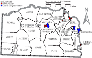
Under Pennsylvania law, there are four types of incorporated municipalities: cities, boroughs, townships, and, in at most two cases, towns. The following boroughs and townships are located in Greene County:
Boroughs
- Carmichaels
- Clarksville
- Greensboro
- Jefferson
- Rices Landing
- Waynesburg (county seat)
Townships
Census-designated places
Census-designated places are geographical areas designated by the U.S. Census Bureau for the purposes of compiling demographic data. They are not actual jurisdictions under Pennsylvania law. Other unincorporated communities, such as villages, may be listed here as well.
Population ranking
The population ranking of the following table is based on the 2010 census of Greene County.[27]
† county seat
| Rank | City/Town/etc. | Municipal type | Population (2010 Census) |
|---|---|---|---|
| 1 | † Waynesburg | Borough | 4,176 |
| 2 | Fairdale | CDP | 2,059 |
| 3 | Morrisville | CDP | 1,265 |
| 4 | Nemacolin | CDP | 937 |
| 5 | Bobtown | CDP | 757 |
| T-6 | Mather | CDP | 737 |
| T-6 | Mount Morris | CDP | 737 |
| 7 | Crucible | CDP | 725 |
| 8 | Dry Tavern | CDP | 697 |
| 9 | Carmichaels | Borough | 483 |
| 10 | Rices Landing | Borough | 463 |
| 11 | West Waynesburg | CDP | 446 |
| 12 | Jefferson | Borough | 270 |
| 13 | Greensboro | Borough | 260 |
| 14 | Rogersville | CDP | 249 |
| 15 | Clarksville | Borough | 230 |
| 16 | Wind Ridge | CDP | 215 |
| 17 | Brave | CDP | 201 |
| 18 | Mapletown | CDP | 130 |
| 19 | New Freeport | CDP | 112 |
See also
- Greene Connections: Greene County, Pennsylvania Archives Project
- National Register of Historic Places listings in Greene County, Pennsylvania
References
- "State & County QuickFacts". United States Census Bureau. Archived from the original on June 6, 2011. Retrieved November 17, 2013.
- "Find a County". National Association of Counties. Archived from the original on May 31, 2011. Retrieved June 7, 2011.
- "2010 Census Gazetteer Files". United States Census Bureau. August 22, 2012. Retrieved March 7, 2015.
- "Census 2020".
- "U.S. Census website". United States Census Bureau. Retrieved January 31, 2008.
- "P2 HISPANIC OR LATINO, AND NOT HISPANIC OR LATINO BY RACE – 2020: DEC Redistricting Data (PL 94-171) – Greene County, Pennsylvania".
- Leip, David. "Dave Leip's Atlas of U.S. Presidential Elections". uselectionatlas.org. Retrieved November 26, 2018.
- "Voter registration statistics by county". dos.pa.gov. November 2, 2021. Retrieved November 2, 2021.
- Thornberg, Ruth. "County Commissioners, Greene County Government, Pennsylvania". www.co.greene.pa.us. Retrieved November 26, 2018.
- http://www.co.greene.pa.us/elections/Default.aspx?PageLayout=SUMMARY&Election=20054.
{{cite web}}: Missing or empty|title=(help) - Center, Legislativate Data Processing. "Find Your Legislator". The official website for the Pennsylvania General Assembly. Retrieved May 11, 2017.
- Klopfer, Milt (September 2, 1998), "Team targets growth", Observer-Reporter, Washington, PA
- "Robert Stephenson Named as President of RIDC; Frank Brooks Robinson, Sr. Steps Down", PR Newswire, April 17, 2003
- Walton, Rod. "Kiewit close to completing 625-MW Hill Top CCGT plant in PA". Power Engineering. Retrieved May 11, 2021.
- Napsha, Joe. "Natural gas-fueled power plants on rise". Trib Total Media. Retrieved May 11, 2021.
- Moore, Daniel (April 5, 2017). "FirstEnergy sells part of former Hatfield power plant to gas developer". Pittsburgh Post-Gazette. Retrieved February 21, 2020.
- Niedbala, Bob. "Company receives final permit for natural gas power plant at Hatfield's Ferry". Observer-Reporter, Washington PA. Retrieved May 10, 2021.
- Tony, Mike (March 20, 2019). "Groundwater pollutants at former Hatfield's Ferry Power Station cited in environmental report". Herald-Standard, Uniontown PA. Retrieved May 10, 2021.
- "1,000 MW Project". American Power Ventures/APV LLC. Retrieved May 10, 2021.
- Thornberg, Ruth. "Education & Schools - Official Website for Greene County Government, Pennsylvania". www.co.greene.pa.us. Retrieved November 26, 2018.
- "2020 CENSUS - SCHOOL DISTRICT REFERENCE MAP: Greene County, PA" (PDF). U.S. Census Bureau. Archived (PDF) from the original on October 9, 2022. Retrieved July 21, 2022. - Text list
- "Top Greene County, PA Private Schools (2018-19)". www.privateschoolreview.com. Retrieved November 26, 2018.
- "Open Door Christian School Profile (2018-19) - Waynesburg, PA". Private School Review. Retrieved November 26, 2018.
- "Explore Open Door Christian School in Waynesburg, PA". GreatSchools.org. Retrieved November 26, 2018.
- "Explore Greene Valley Christian Academ in Rices Landing, PA". GreatSchools.org. Retrieved November 26, 2018.
- FAA Airport Form 5010 for WAY PDF. Federal Aviation Administration. Effective May 31, 2012.
- "2010 U.S. Census website". United States Census Bureau. Retrieved February 10, 2013.
Further reading
- Martines, Jamie. A Pennsylvania county went from bust to boom times with natural gas. Now, it’s nearly broke. Spotlight PA. March 8, 2021
- White-Nockleby, Caroline; Wahid, Mimi; Boone, Caroline; Delhees, Benjamin. Changes in the contribution of coal to tax revenues in Greene County, PA, 2010-2019 Massachusetts Institute of Technology Environmental Solutions Initiative. March 2021.
- Ohio River Valley Institute. Appalachia's Natural Gas Counties: Contributing more to the U.S. economy and getting less in return. The Natural Gas Fracking Boom and Appalachia's Lost Economic Decade February 12, 2021.
External links
Places adjacent to Greene County, Pennsylvania | ||||||||||||||||
|---|---|---|---|---|---|---|---|---|---|---|---|---|---|---|---|---|
| ||||||||||||||||
Municipalities and communities of Greene County, Pennsylvania, United States | ||
|---|---|---|
County seat: Waynesburg | ||
| Boroughs |  | |
| Townships | ||
| CDPs | ||
| Unincorporated communities |
| |
| ||
Authority control | |
|---|---|
| General | |
| National libraries | |
| Other | |
На других языках
[de] Greene County (Pennsylvania)
Das Greene County[1] ist ein County im US-Bundesstaat Pennsylvania. Bei der Volkszählung im Jahr 2020 hatte das County 35.954 Einwohner und eine Bevölkerungsdichte von 24,1 Einwohnern pro Quadratkilometer.[2] Der Verwaltungssitz (County Seat) ist Waynesburg.- [en] Greene County, Pennsylvania
[ru] Грин (округ, Пенсильвания)
Грин (англ. Greene County) — округ в США, штате Пенсильвания. Официально образован 9 февраля 1796 года. По состоянию на 2010 год, численность населения составляла 38 686 человек. Получил своё название в честь американского генерала Натаниэля Грина.Другой контент может иметь иную лицензию. Перед использованием материалов сайта WikiSort.org внимательно изучите правила лицензирования конкретных элементов наполнения сайта.
WikiSort.org - проект по пересортировке и дополнению контента Википедии