world.wikisort.org - USA
Susquehanna County is a county located in the northeastern part of the U.S. state of Pennsylvania. As of the 2020 census, the population was 38,434[1] Its county seat is Montrose.[2] The county was created on February 21, 1810, from part of Luzerne County[3] and later organized in 1812.[4] It is named for the Susquehanna River.
Susquehanna County | |
|---|---|
U.S. county | |
 The Susquehanna County Courthouse in Montrose | |
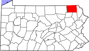 Location within the U.S. state of Pennsylvania | |
 Pennsylvania's location within the U.S. | |
| Coordinates: 41°49′17″N 75°48′02″W | |
| Country | |
| State | |
| Founded | October 13, 1812 |
| Named for | Susquehanna River |
| Seat | Montrose |
| Largest borough | Forest City |
| Area | |
| • Total | 832 sq mi (2,150 km2) |
| • Land | 823 sq mi (2,130 km2) |
| • Water | 8.7 sq mi (23 km2) 1.0% |
| Population (2020) | |
| • Total | 38,434 |
| • Density | 46/sq mi (18/km2) |
| Time zone | UTC−5 (Eastern) |
| • Summer (DST) | UTC−4 (EDT) |
| Congressional district | 12th |
| Website | www |
History
Settlement and conflict
The first non-Indigenous settlers began to move into the area from Philadelphia and Connecticut in the mid-1700s. At the time, the area was part of Luzerne County. As more and more people from Connecticut moved in, there began to be some conflict. Under Connecticut's land grant, they owned everything from present-day Connecticut to the Pacific Ocean. This meant their land grant overlapped with Pennsylvania's land grant. Soon fighting began – the 1769–1799 Pennamite–Yankee Wars. In the end, the government of Connecticut surrendered its claim on the area.
Formation
In 1810, Susquehanna County was formed out of Luzerne County and later in 1812, Montrose was made the county seat.
Coal and early prosperity
After the Civil War, coal started to be mined. Following this, railways and roads were built into the county allowing for more people to come. At one point the county had nearly 50,000 people. Coal became, as with neighboring counties, the backbone of the economy. This boom in coal would allow for an age of prosperity in the county.
Great Depression
When the Great Depression hit, the coal industry suffered horribly. Within months, the coal industry was struggling. During World War II, the coal industry picked up again, but only for a short time. Soon after, the economy in the county failed. Many mines were closed, railways were torn apart, and the economy took a turn for the worse. Unemployment rose and population decline increased.[dubious ]
Geography

According to the U.S. Census Bureau, the county has a total area of 832 square miles (2,150 km2), of which 823 square miles (2,130 km2) is land and 8.7 square miles (23 km2) (1.0%) is water.[5]
Susquehanna County is very mountainous, with large concentrations of mountains in the east and smaller, more hill-like mountains in the west. The highest mountain in the county is North Knob just west of Union Dale. Most people live in one of the several long and mostly narrow valleys. These valleys are good farming land.
The county has a warm-summer humid continental climate (Dfb) and average monthly temperatures in Montrose range from 21.2 °F in January to 67.7 °F in July.[6]
Adjacent counties
- Broome County, New York (north)
- Wayne County (east)
- Lackawanna County (southeast)
- Wyoming County (southwest)
- Bradford County (west)
- Tioga County, New York (northwest)
Demographics
| Historical population | |||
|---|---|---|---|
| Census | Pop. | %± | |
| 1820 | 9,960 | — | |
| 1830 | 16,787 | 68.5% | |
| 1840 | 21,195 | 26.3% | |
| 1850 | 28,688 | 35.4% | |
| 1860 | 36,267 | 26.4% | |
| 1870 | 37,523 | 3.5% | |
| 1880 | 40,354 | 7.5% | |
| 1890 | 40,093 | −0.6% | |
| 1900 | 40,043 | −0.1% | |
| 1910 | 37,746 | −5.7% | |
| 1920 | 34,763 | −7.9% | |
| 1930 | 33,806 | −2.8% | |
| 1940 | 33,893 | 0.3% | |
| 1950 | 31,970 | −5.7% | |
| 1960 | 33,137 | 3.7% | |
| 1970 | 34,344 | 3.6% | |
| 1980 | 37,876 | 10.3% | |
| 1990 | 40,380 | 6.6% | |
| 2000 | 42,238 | 4.6% | |
| 2010 | 43,356 | 2.6% | |
| 2020 | 38,434 | −11.4% | |
| U.S. Decennial Census[7] 1790-1960[8] 1900-1990[9] 1990-2000[10] 2010-2017[1] | |||
As of the census[11] of 2000, there were 42,238 people, 16,529 households, and 11,785 families residing in the county. The population density was 51 people per square mile (20/km2). There were 21,829 housing units at an average density of 26 per square mile (10/km2). The racial makeup of the county was 98.54% White, 0.30% Black or African American, 0.15% Native American, 0.22% Asian, 0.01% Pacific Islander, 0.17% from other races, and 0.60% from two or more races. 0.67% of the population were Hispanic or Latino of any race. 26% were of English, 16.1% were of German, 15.1% Irish, 8.6% Italian and 7.7% Polish ancestry.
There were 16,529 households, out of which 31.90% had children under the age of 18 living with them, 57.70% were married couples living together, 8.60% had a female householder with no husband present, and 28.70% were non-families. 24.30% of all households were made up of individuals, and 11.50% had someone living alone who was 65 years of age or older. The average household size was 2.53 and the average family size was 2.99.
In the county, the population was spread out, with 25.50% under the age of 18, 6.70% from 18 to 24, 27.10% from 25 to 44, 25.20% from 45 to 64, and 15.50% who were 65 years of age or older. The median age was 40 years. For every 100 females, there were 98.90 males. For every 100 females age 18 and over, there were 95.80 males.
2020 Census
| Race | Num. | Perc. |
|---|---|---|
| White (NH) | 35,799 | 93.14% |
| Black or African American (NH) | 138 | 0.36% |
| Native American (NH) | 59 | 0.15% |
| Asian (NH) | 135 | 0.35% |
| Pacific Islander (NH) | 0 | 0% |
| Other/Mixed (NH) | 1,456 | 3.8% |
| Hispanic or Latino | 847 | 2.2% |
Politics
| Year | Republican | Democratic | Third party | |||
|---|---|---|---|---|---|---|
| No. | % | No. | % | No. | % | |
| 2020 | 15,207 | 69.72% | 6,236 | 28.59% | 370 | 1.70% |
| 2016 | 12,891 | 67.69% | 5,123 | 26.90% | 1,029 | 5.40% |
| 2012 | 10,800 | 59.62% | 6,935 | 38.28% | 381 | 2.10% |
| 2008 | 10,633 | 54.77% | 8,381 | 43.17% | 401 | 2.07% |
| 2004 | 11,573 | 60.78% | 7,351 | 38.61% | 116 | 0.61% |
| 2000 | 10,226 | 59.21% | 6,481 | 37.53% | 564 | 3.27% |
| 1996 | 7,354 | 47.03% | 5,912 | 37.81% | 2,370 | 15.16% |
| 1992 | 7,356 | 44.02% | 5,368 | 32.13% | 3,985 | 23.85% |
| 1988 | 9,077 | 64.58% | 4,871 | 34.65% | 108 | 0.77% |
| 1984 | 10,566 | 69.95% | 4,471 | 29.60% | 67 | 0.44% |
| 1980 | 8,994 | 61.23% | 4,660 | 31.72% | 1,035 | 7.05% |
| 1976 | 8,331 | 56.74% | 6,075 | 41.38% | 276 | 1.88% |
| 1972 | 9,476 | 67.79% | 4,154 | 29.72% | 349 | 2.50% |
| 1968 | 8,705 | 62.04% | 4,364 | 31.10% | 963 | 6.86% |
| 1964 | 6,567 | 45.55% | 7,838 | 54.37% | 12 | 0.08% |
| 1960 | 10,201 | 63.88% | 5,760 | 36.07% | 9 | 0.06% |
| 1956 | 10,752 | 71.42% | 4,293 | 28.52% | 10 | 0.07% |
| 1952 | 10,529 | 73.97% | 3,653 | 25.66% | 52 | 0.37% |
| 1948 | 7,945 | 67.81% | 3,621 | 30.91% | 150 | 1.28% |
| 1944 | 8,819 | 67.42% | 4,212 | 32.20% | 49 | 0.37% |
| 1940 | 9,520 | 63.71% | 5,383 | 36.03% | 39 | 0.26% |
| 1936 | 9,745 | 58.94% | 6,520 | 39.43% | 269 | 1.63% |
| 1932 | 6,884 | 55.99% | 5,171 | 42.06% | 240 | 1.95% |
| 1928 | 9,445 | 68.14% | 4,353 | 31.40% | 63 | 0.45% |
| 1924 | 7,266 | 67.38% | 2,208 | 20.47% | 1,310 | 12.15% |
| 1920 | 6,572 | 66.41% | 2,905 | 29.36% | 419 | 4.23% |
| 1916 | 3,891 | 53.08% | 3,145 | 42.91% | 294 | 4.01% |
| 1912 | 1,988 | 26.87% | 2,588 | 34.98% | 2,822 | 38.15% |
| 1908 | 4,999 | 57.30% | 3,230 | 37.02% | 496 | 5.68% |
| 1904 | 4,988 | 61.20% | 2,573 | 31.57% | 589 | 7.23% |
| 1900 | 5,019 | 55.24% | 3,527 | 38.82% | 539 | 5.93% |
| 1896 | 5,310 | 56.73% | 3,618 | 38.65% | 432 | 4.62% |
| 1892 | 4,531 | 53.14% | 3,383 | 39.67% | 613 | 7.19% |
| 1888 | 5,019 | 55.30% | 3,328 | 36.67% | 729 | 8.03% |
As of November 1, 2021, there are 26,669 registered voters in Susquehanna County.[15]
- Republican: 16,114 (60.42%)
- Democratic: 6,989 (26.21%)
- Independent: 2,260 (8.47%)
- Third Party: 1,306 (4.9%)
County Commissioners
- Judith Herschel, Democrat (January 2020 to present)
- Alan M. Hall, Chair, Republican (January 2012 to present)
- Elizabeth M. Arnold, Vice-Chair, Republican (January 2016)
Row Offices
- Clerk of Courts and Prothonotary, Jan Krupinski, Republican
- Coroner, Tony Conarton, Republican
- District Attorney, Marion O'Malley, Republican [16]
- Recorder of Deeds and Register of Wills, Michelle Estabrook, Republican
- Sheriff, Lance Benedict, Republican
- Treasurer, Jason Miller, Republican
- Auditor, George Starzec, Republican
- Auditor, Susan Jennings, Democrat
State Representatives[17]
- Tina Pickett, Republican (110th district) - Apolacon, Auburn, Dimock, Forest Lake, Jessup, Middletown, and Rush Townships, and Little Meadows Borough
- Jonathan Fritz, Republican (111th district) - Ararat, Bridgewater, Brooklyn, Choconut, Clifford, Franklin, Gibson, Great Bend, Harford, Harmony, Herrick, Jackson, Lathrop, Lenox, Liberty, New Milford, Oakland, Silver Lake, Springville, and Thompson Townships, and Friendsville, Great Bend, Hallstead, Hop Bottom, Lanesboro, Montrose, New Milford, Oakland, Susquehanna Depot, Thompson, and Union Dale Boroughs
State Senators[17]
- Lisa Baker, Republican (20th district) - Ararat, Auburn, Brooklyn, Clifford, Gibson, Great Bend, Harford, Harmony, Herrick, Jackson, Lathrop, Lenox, New Milford, Oakland, Springville, and Thompson Townships, and Forest City, Great Bend, Hallstead, Hop Bottom, Lanesboro, New Milford, Oakland, Susquehanna Depot, Thompson, and Union Dale Boroughs
- Gene Yaw, Republican (23rd district) - Apolacon, Bridgewater, Choconut, Dimock, Forest Lake, Franklin, Jessup, Liberty, Middletown, Rush and Silver Lake Townships, and Friendsville, Little Meadows, and Montrose Boroughs
U.S. Representative
- Fred Keller, Republican (PA-12)
United States Senate
- Pat Toomey, Republican
- Bob Casey Jr., Democrat
Economy
The economy in the county is mainly made up of retail, health care industry, public school employment, small businesses, and government officials.[18]
Major employers
- 2018
Listed in order of number of employees at the end of 2018, according to the Pennsylvania Department of Labor and Industry May 2019 monthly report:[19]
- Montrose Area School District
- Barnes-Kasson County Hospital
- Pennsylvania State Government
- Endless Mountains Health Systems
- Susquehanna County government
- Mountain View School District
- Elk Lake School District
- Gassearch Drilling Services Corp
- Blue Ridge School District
- Cabot Oil & Gas Corporation
- 2015[20]
- Barnes-Kasson County Hospital
- Montrose Area School District
- Endless Mountains Health Systems
- C & G Construction Inc
- Elk Lake School District
- Susquehanna County government
- Mountain View School District
- Pennsylvania State Government
- Gassearch Drilling Services Corp
- Blue Ridge School District
- 2014[21]
- Montrose Area School District
- Barnes-Kasson County Hospital
- Gassearch Drilling Services Corp
- Endless Mountains Health Systems
- Elk Lake School District
- Blue Ridge School District
- Susquehanna County government
- Mountain View School District
- Elk Mountain Ski Resort INC
- Forest City Regional School District
Natural gas
Since unconventional drilling for natural gas began in 2008, some say the economy has improved. [citation needed] According to the U.S. Bureau of Labor Statistics, the unemployment rate in Susquehanna County was 6.1 percent in January 2008. It has since fluctuated between a high of 11.1 percent and a low of 3.1 percent. As of January 2018, the unemployment rate was 5.7 percent.[22] After decades of population growth since the 1950s, the population in Susquehanna County has since begun to decline, concurrent with the expansion of natural gas drilling and accompanying infrastructure. Between 2010 and 2016, there was an estimated population decline of 5.8 percent. As of 2011, there were 1,079 active natural gas wells in the county which had collectively been issued 795 notices of violations by the Department of Environmental Protection of Pennsylvania.[23]
Tourism
Susquehanna County's natural environment, skiing, and small villages make it a growing tourist destination.[citation needed]
Education
Public libraries
- Susquehanna County Historical Society & Free Library Association
- Pratt Memorial Library
- Forest City Library
- Hallstead Public Library
- Hallstead-Great Bend Library
- Susquehanna Free Library
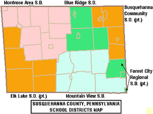
Public school districts
- Blue Ridge School District (New Milford)
- Elk Lake School District (Dimock) (also in Wyoming County)
- Forest City Regional School District (Forest City) (also in Lackawanna and Wayne Counties)
- Montrose Area School District (Montrose)
- Mountain View School District (Kingsley)
- Susquehanna Community School District (also in Wayne County)
Vocational schools
- Susquehanna County Career and Technology Center (Dimock Township)
Intermediate unit
- Luzerne Intermediate Unit 18
Northeast Intermediate Unit 19 (NEIU 19)
Private schools
- Faith Mountain Christian Academy (New Milford)
Transportation
Major Highways
 I-81
I-81 US 11
US 11 PA 29
PA 29 PA 92
PA 92 PA 106
 PA 167
 PA 171
 PA 247
 PA 267
 PA 367
 PA 370
 PA 371
 PA 374
 PA 407
 PA 492
 PA 547
 PA 706
 PA 848
 PA 858
Rail
Susquehanna County's last mainline passenger train services, through New Milford and Hallstead, ended in January 1970. Since then, freight trains (presently Norfolk Southern) use the railroad line.
Air
Although Susquehanna County boasts several airstrips, they are strictly recreational. The closest main airports are in Binghamton, New York and Scranton, Pennsylvania.
Recreation
There is one Pennsylvania state park in Susquehanna County:
- Salt Springs State Park is 7 miles (11 km) north of Montrose, just off Pennsylvania Route 29.
Communities
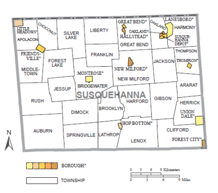
Under Pennsylvania law, there are four types of incorporated municipalities: cities, boroughs, townships, and, in two cases at most, towns. The following boroughs and townships are located in Susquehanna County:
Boroughs
Townships
Population ranking
The population ranking of the following table is based on the 2010 census of Susquehanna County.[24]
† county seat
| Rank | Borough/Township | Municipal type | Population (2010 Census) |
|---|---|---|---|
| 1 | Bridgewater | Township | 2,844 |
| 2 | Clifford | Township | 2,408 |
| 3 | New Milford | Township | 2,042 |
| 4 | Great Bend | Township | 1,949 |
| 5 | Auburn | Township | 1,939 |
| 6 | Lenox | Township | 1,934 |
| 7 | Forest City | Borough | 1,911 |
| 8 | Silver Lake | Township | 1,716 |
| 9 | Susquehanna Depot | Borough | 1,643 |
| 10 | Springville | Township | 1,641 |
| 11 | † Montrose | Borough | 1,617 |
| 12 | Dimock | Township | 1,497 |
| 13 | Harford | Township | 1,430 |
| 14 | Hallstead | Borough | 1,303 |
| 15 | Liberty | Township | 1,292 |
| 16 | Rush | Township | 1,267 |
| 17 | Gibson | Township | 1,221 |
| 18 | Forest Lake | Township | 1,193 |
| 19 | Brooklyn | Township | 963 |
| 20 | Franklin | Township | 937 |
| 21 | New Milford | Borough | 868 |
| 22 | Jackson | Township | 848 |
| 23 | Lathrop | Township | 841 |
| 24 | Great Bend | Borough | 734 |
| 25 | Choconut | Township | 713 |
| 26 | Herrick | Township | 713 |
| 27 | Oakland | Borough | 616 |
| 28 | Oakland | Township | 564 |
| 29 | Ararat | Township | 563 |
| 30 | Jessup | Township | 536 |
| 31 | Harmony | Township | 528 |
| 32 | Lanesboro | Borough | 506 |
| 33 | Apolacon | Township | 500 |
| 34 | Thompson | Township | 410 |
| 35 | Middletown | Township | 382 |
| 36 | Hop Bottom | Borough | 337 |
| 37 | Thompson | Borough | 299 |
| 38 | Little Meadows | Borough | 273 |
| 39 | Union Dale | Borough | 267 |
| 40 | Friendsville | Borough | 111 |
See also
- National Register of Historic Places listings in Susquehanna County, Pennsylvania
- Woodbourne Forest and Wildlife Preserve
References
- "State & County QuickFacts". United States Census Bureau. Retrieved November 22, 2013.
- "Find a County". National Association of Counties. Retrieved June 7, 2011.
- "Township Incorporations, 1790 to 1853". Susquehanna County Historical Society. Archived from the original on June 23, 2015. Retrieved March 9, 2013.
- "Pennsylvania: Individual County Chronologies". Pennsylvania Atlas of Historical County Boundaries. The Newberry Library. 2008. Archived from the original on March 25, 2015. Retrieved March 13, 2015.
- "2010 Census Gazetteer Files". United States Census Bureau. August 22, 2012. Retrieved March 10, 2015.
- Parameter-elevation Regressions on Independent Slopes Model
- "U.S. Decennial Census". United States Census Bureau. Retrieved March 10, 2015.
- "Historical Census Browser". University of Virginia Library. Retrieved March 10, 2015.
- Forstall, Richard L., ed. (March 24, 1995). "Population of Counties by Decennial Census: 1900 to 1990". United States Census Bureau. Retrieved March 10, 2015.
- "Census 2000 PHC-T-4. Ranking Tables for Counties: 1990 and 2000" (PDF). United States Census Bureau. April 2, 2001. Archived (PDF) from the original on October 9, 2022. Retrieved March 10, 2015.
- "U.S. Census website". United States Census Bureau. Retrieved May 14, 2011.
- "P2 HISPANIC OR LATINO, AND NOT HISPANIC OR LATINO BY RACE – 2020: DEC Redistricting Data (PL 94-171) – Susquehanna County, Pennsylvania".
- Leip, David. "Dave Leip's Atlas of U.S. Presidential Elections". uselectionatlas.org. Retrieved February 21, 2021.
- The leading "other" candidate, Progressive Theodore Roosevelt, received 2,498 votes, while Socialist candidate Eugene Debs received 298 votes, Prohibition candidate Eugene Chafin received 25 votes, and Socialist Labor candidate Arthur Reimer received 1 vote.
- "Voter registration statistics by county".
- Bugda, Jayne Ann (February 5, 2018). "Marion O'Malley Sworn in as Susquehanna County D.A." PAHOMEPAGE. Retrieved November 29, 2018.
- Center, Legislativate Data Processing. "Find Your Legislator". The official website for the Pennsylvania General Assembly. Retrieved May 12, 2017.
- Pennsylvania Department of Community and Economic Development (2015). "Susquehanna County Profile".
- Pennsylvania Department of Labor and Industry (May 2019). "Susquehanna County Profile" (PDF).
- Pennsylvania Department of Labor and Industry (April 2016). "Susquehanna County Profile" (PDF).
- PA Department of Labor and Industries - Center for Workforce Information & Analysis, Susquehanna County Profile 2014, October 2015
- U.S. Bureau of Labor Statistics (2018). "Unemployment Rate in Susquehanna County, PA".
- NPR State Impact (2018). "Shale Play Susquehanna County Natural Gas Wells Map showing active wells and violations".
- Promotions, Center for New Media and. "US Census Bureau 2010 Census". www.census.gov. Retrieved April 3, 2018.
External links
Places adjacent to Susquehanna County, Pennsylvania | ||||||||||||||||
|---|---|---|---|---|---|---|---|---|---|---|---|---|---|---|---|---|
| ||||||||||||||||
Municipalities and communities of Susquehanna County, Pennsylvania, United States | ||
|---|---|---|
County seat: Montrose | ||
| Boroughs | 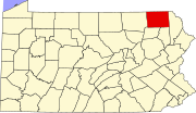 | |
| Townships | ||
| Unincorporated communities | ||
| ||
Authority control | |
|---|---|
| General | |
| National libraries | |
| Other | |
На других языках
[de] Susquehanna County
Susquehanna County[1] ist ein County im US-Bundesstaat Pennsylvania. Bei der Volkszählung im Jahr 2020 hatte das County 38.434 Einwohner und eine Bevölkerungsdichte von nahezu 18 Einwohnern pro Quadratkilometer.[2] Der Verwaltungssitz (County Seat) ist Montrose.- [en] Susquehanna County, Pennsylvania
[es] Condado de Susquehanna
El condado de Susquehanna es un condado ubicado en el estado de Pensilvania. En 2000, su población era de 42.238 habitantes. El condado de Susquehanna fue fundado en 1810 a partir de parte del condado de Luzerne. Su sede está en Montrose.[ru] Саскуэханна (округ)
Округ Саскуэханна (англ. Susquehanna County) располагается в штате Пенсильвания, США. Официально образован 21 февраля 1810 года. По состоянию на 2010 год численность населения составляла 43 356 человек.Другой контент может иметь иную лицензию. Перед использованием материалов сайта WikiSort.org внимательно изучите правила лицензирования конкретных элементов наполнения сайта.
WikiSort.org - проект по пересортировке и дополнению контента Википедии