world.wikisort.org - USA
Randolph County is a county located in the U.S. state of North Carolina. As of the 2020 census, the population was 144,171.[1] Its county seat is Asheboro.[2]
Randolph County | |
|---|---|
U.S. county | |
 Randolph County Courthouse and Confederate statue | |
 Flag  Seal Logo | |
| Motto: "Serving with Heart from the Heart of North Carolina" | |
 Location within the U.S. state of North Carolina | |
 North Carolina's location within the U.S. | |
| Coordinates: 35°43′N 79°49′W | |
| Country | |
| State | |
| Founded | 1779 |
| Named for | Peyton Randolph |
| Seat | Asheboro |
| Largest city | Asheboro |
| Area | |
| • Total | 789 sq mi (2,040 km2) |
| • Land | 783 sq mi (2,030 km2) |
| • Water | 6.8 sq mi (18 km2) 0.9% |
| Population | |
| • Estimate (2021) | 145,172 |
| • Density | 185.4/sq mi (71.6/km2) |
| Time zone | UTC−5 (Eastern) |
| • Summer (DST) | UTC−4 (EDT) |
| Congressional district | 9th |
| Website | www |

Randolph County is included in the Greensboro-High Point, NC Metropolitan Statistical Area, which is also included in the Greensboro-Winston-Salem-High Point, NC Combined Statistical Area.
In 2010, the center of population of North Carolina was located in Randolph County, near the town of Seagrove.[3]
History
Some of the first European settlers in this area of the Piedmont and what would become the county were English Quakers, who settled along the Haw, Deep, and Eno rivers[4] The county was formed in 1779 from Guilford County. It was named for Peyton Randolph, first president of the Continental Congress.
County formation
The Legislature of 1779, then sitting at Halifax, passed an act providing for the formation of a new county from parts of Guilford and Rowan, to be called Randolph.[5]
Randolph County was the original location of the school that developed as Duke University.
The county is home to one of the last remaining covered bridges in the state. The Pisgah Covered Bridge, in Union Township in the southwestern part of the county, was destroyed by a flood in 2003, but has been rebuilt.[6][7]
In 1911, a new county called Piedmont County was proposed, with High Point as its county seat, to be created from Guilford, Davidson, and Randolph counties. Many people appeared at the Guilford County courthouse to oppose the plan, vowing to go to the state legislature to protest. The state legislature voted down the plan in February 1911.[8][9]
Geography

According to the U.S. Census Bureau, the county has a total area of 789 square miles (2,040 km2), of which 783 square miles (2,030 km2) is land and 6.8 square miles (18 km2) (0.9%) is covered by water.[10]
Randolph County is located in the center of North Carolina, and the city of Asheboro (in the county) is the center point of North Carolina. Randolph County is located in the Piedmont section of central North Carolina, generally a region of gently rolling hills and woodlands. The central and western parts of the county contain the Uwharrie Mountains and the Caraway Mountains. These two ranges are the remnants of a much-higher range of ancient peaks. Today, they rarely top 1,000 feet (300 m) above sea level, yet due to the relative low terrain around them, they still rise 200–500 feet (61–152 m) above their base.
The highest point in Randolph County is Shepherd Mountain, a peak in the Caraways. The North Carolina Zoo is located atop Purgatory Mountain, one of the peaks of the Uwharries.
National protected area
- Birkhead Mountains Wilderness
- Uwharrie National Forest
State and local protected areas/sites
- Liberty Raceway Park[11]
- North Carolina Zoo
- Pisgah Covered Bridge
Major water bodies
- Back Creek (Caraway Creek tributary)
- Bush Creek (Deep River tributary)
- Caraway Creek (Uwharrie River tributary)
- Deep River
- Little Caraway Creek (Caraway Creek tributary)
- Little River
- Little Uwharrie River
- Randleman Lake
- Reed Creek (Deep River tributary)
- Rocky River
- Toms Creek (Uwharrie River tributary)
- Uwharrie River
Adjacent counties
- Guilford County - north
- Alamance County - northeast
- Chatham County - east
- Moore County - southeast
- Montgomery County - southwest
- Davidson County - west
Major highways
 I-73
I-73 I-74
I-74 I-85
I-85 I-85 BL
 Future I-685 (Concurrency with US 421)
 US 29
US 29 US 64
US 64 US 64 Bus.
 US 70
US 70 US 220
 US 220 Alt.
- US 220 Bus.
 US 311
 US 421
 NC 22
NC 22 NC 42
NC 42 NC 47
NC 47 NC 49
NC 49 NC 62
NC 62 NC 109
 NC 134
 NC 159
 NC 159 Spur (Spur Route)
 NC 705
Major infrastructure
Demographics
| Historical population | |||
|---|---|---|---|
| Census | Pop. | %± | |
| 1790 | 7,318 | — | |
| 1800 | 9,234 | 26.2% | |
| 1810 | 10,112 | 9.5% | |
| 1820 | 11,331 | 12.1% | |
| 1830 | 12,406 | 9.5% | |
| 1840 | 12,875 | 3.8% | |
| 1850 | 15,832 | 23.0% | |
| 1860 | 16,793 | 6.1% | |
| 1870 | 17,551 | 4.5% | |
| 1880 | 20,836 | 18.7% | |
| 1890 | 25,195 | 20.9% | |
| 1900 | 28,232 | 12.1% | |
| 1910 | 29,491 | 4.5% | |
| 1920 | 30,856 | 4.6% | |
| 1930 | 36,259 | 17.5% | |
| 1940 | 44,554 | 22.9% | |
| 1950 | 50,804 | 14.0% | |
| 1960 | 61,497 | 21.0% | |
| 1970 | 76,358 | 24.2% | |
| 1980 | 91,728 | 20.1% | |
| 1990 | 106,546 | 16.2% | |
| 2000 | 130,454 | 22.4% | |
| 2010 | 141,752 | 8.7% | |
| 2020 | 144,171 | 1.7% | |
| 2021 (est.) | 145,172 | [12] | 0.7% |
| U.S. Decennial Census[13] 1790-1960[14] 1900-1990[15] 1990-2000[16] 2010-2019[17] 2020[18] | |||
2020 census
| Race | Number | Percentage |
|---|---|---|
| White (non-Hispanic) | 108,354 | 75.16% |
| Black or African American (non-Hispanic) | 8,592 | 5.96% |
| Native American | 666 | 0.46% |
| Asian | 2,158 | 1.5% |
| Pacific Islander | 10 | 0.01% |
| Other/Mixed | 5,340 | 3.7% |
| Hispanic or Latino | 19,051 | 13.21% |
As of the 2020 United States census, there were 144,171 people, 56,117 households, and 37,795 families residing in the county.
2000 census
As of the census[20] of 2000, 130,454 people, 50,659 households, and 37,335 families resided in the county. The population density was 166 people per square mile (64/km2). The 54,422 housing units averaged 69 per square mile (27/km2). The racial makeup of the county was 89.20% White, 5.63% Black or African American, 0.45% Native American, 0.64% Asian, 0.02% Pacific Islander, 3.01% from other races, and 1.06% from two or more races. About 6.63% of the population was Hispanic or Latino of any race.
As with much of North Carolina, the Latino population of Randolph County continued to grow into the 21st century. In 2005, figures placed the Latino population as 9.3% of the county's total.
In 2000, of the 50,659 households, 33.70% had children under the age of 18 living with them, 59.10% were married couples living together, 10.20% had a female householder with no husband present, and 26.30% were not families. About 22.50% of all households were made up of individuals, and 8.60% had someone living alone who was 65 years of age or older. The average household size was 2.55 and the average family size was 2.97.
In the county, the population was distributed as 25.00% under the age of 18, 8.00% from 18 to 24, 31.30% from 25 to 44, 23.50% from 45 to 64, and 12.10% who were 65 years of age or older. The median age was 36 years. For every 100 females, there were 97.80 males. For every 100 females age 18 and over, there were 95.40 males.
The median income for a household in the county was $38,348, and for a family was $44,369. Males had a median income of $30,575 versus $22,503 for females. The per capita income for the county was $18,236. About 6.80% of families and 9.10% of the population were below the poverty line, including 11.60% of those under age 18 and 11.50% of those age 65 or over.
Government and politics
Randolph County is a member of the regional Piedmont Triad Council of Governments.
The county was one of the earliest in North Carolina and the South to turn Republican, and is often considered one of the most Republican-dominated counties in the state. It has supported the Republican presidential candidate in all but three elections since 1916. No Democratic presidential nominee has carried the county since Franklin D. Roosevelt in 1940, and Jimmy Carter is the last Democrat to even tally 40 percent of the county's vote. In 1964, it was one of only 13 counties in the state to vote for Barry Goldwater, and the easternmost county in the state to do so. Republican dominance at the local level is so absolute that in some cases, Republican candidates and incumbents run unopposed.
| Year | Republican | Democratic | Third parties |
|---|---|---|---|
| 2020 | 77.6% 56,894 | 21.3% 15,618 | 1.1% 804 |
| 2016 | 76.6% 49,430 | 20.4% 13,194 | 3.0% 1,951 |
| 2012 | 74.4% 45,160 | 24.3% 14,773 | 1.3% 782 |
| 2008 | 70.5% 40,998 | 28.2% 16,414 | 1.3% 735 |
| 2004 | 74.2% 37,771 | 25.5% 12,966 | 0.3% 173 |
| 2000 | 72.5% 30,959 | 26.6% 11,366 | 0.9% 371 |
| 1996 | 61.4% 23,030 | 28.7% 10,783 | 9.9% 3,722 |
| 1992 | 53.2% 20,697 | 29.0% 11,274 | 17.8% 6,931 |
| 1988 | 73.3% 23,881 | 26.5% 8,641 | 0.2% 49 |
| 1984 | 77.4% 25,759 | 22.6% 7,511 | 0.1% 29 |
| 1980 | 64.7% 19,881 | 32.9% 10,107 | 2.4% 729 |
| 1976 | 52.7% 14,337 | 46.8% 12,714 | 0.5% 146 |
| 1972 | 76.0% 18,724 | 21.7% 5,346 | 2.3% 559 |
| 1968 | 52.4% 13,450 | 20.8% 5,351 | 26.8% 6,892 |
| 1964 | 56.4% 13,739 | 43.6% 10,638 | |
| 1960 | 61.7% 15,772 | 38.3% 9,789 | |
| 1956 | 61.1% 13,174 | 39.0% 8,404 | |
| 1952 | 58.1% 12,429 | 41.9% 8,975 | |
| 1948 | 53.4% 8,372 | 41.9% 6,567 | 4.7% 743 |
| 1944 | 54.7% 8,768 | 45.4% 7,277 | |
| 1940 | 45.5% 7,056 | 54.5% 8,455 | |
| 1936 | 46.1% 6,927 | 53.9% 8,090 | |
| 1932 | 45.0% 6,072 | 54.4% 7,345 | 0.6% 75 |
| 1928 | 63.9% 7,414 | 36.1% 4,188 | |
| 1924 | 53.9% 6,336 | 45.9% 5,397 | 0.2% 24 |
| 1920 | 55.2% 6,297 | 44.8% 5,110 | |
| 1916 | 52.4% 3,031 | 47.5% 2,747 | 0.1% 3 |
| 1912 | 7.6% 370 | 55.0% 2,665 | 37.4% 1,815 |
| 1908 | 52.0% 2,676' | 48.0% 2,472 | |
| 1904 | 43.4% 1,808 | 56.1% 2,334 | 0.5% 21 |
| 1900 | 52.0% 2,487 | 47.4% 2,264 | 0.6% 28 |
| 1896 | 51.5% 2,743 | 46.6% 2,482 | 2.0% 104 |
| 1892 | 39.1% 1,883 | 43.1% 2,077 | 17.8% 857 |
| 1888 | 49.5% 2,339 | 44.9% 2,121 | 5.6% 262 |
| 1884 | 46.9% 1,890 | 48.8% 1,968 | 4.3% 172 |
| 1880 | 47.5% 1,811 | 52.5% 2,005 |
Education
- Randolph County School System serves most of the county. Asheboro City Schools serves Asheboro.
- Fayetteville Street Christian School, located in Asheboro, is the largest private school in Randolph County.[23]
Communities
Cities
- Archdale (part)
- Asheboro (county seat and largest city)
- High Point (part)
- Randleman
- Thomasville (part)
- Trinity
Towns
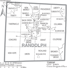
Townships
- Asheboro
- Archdale
- Back Creek
- Brower
- Cedar Grove
- Coleridge
- Columbia
- Concord
- Farmer
- Franklinville
- Grant
- Level Cross
- Liberty
- New Hope
- New Market
- Pleasant Grove
- Providence
- Randleman
- Richland
- Tabernacle
- Trinity
- Union
Unincorporated communities
- Cedar Grove
- Climax
- Coleridge
- Erect
- Farmer
- Level Cross
- Pisgah
- Sophia
- Ulah
- Whynot
Notable people
- Sam Ard - NASCAR driver; 1983 and 1984 Busch Series champion
- Adam Petty - NASCAR driver. Son of Kyle Petty. Killed in New Hampshire.
- Braxton Craven - educator and second president of Trinity College, which later moved to Durham and became Duke University.
- Henderson Luelling, Quaker abolitionist, horticulturist (born here)<https://en.wikipedia.org/wiki/Henderson_Luelling>
- Gideon Morris - trans-Appalachian pioneer and founder of Morristown, Tennessee
- Heaven Fitch - wrestler
- Heidi N. Closet - African-American drag queen & contestant of RuPaul's Drag Race, season 12.
- Jerry Bledsoe - author
- Jonathan Worth - North Carolina Governor
- Kyle Petty - NASCAR driver. Son of Richard Petty
- Lee Petty - NASCAR pioneer. Father of Richard Petty
- Rufus Hussey - The Beanshooter Man who appeared on The Tonight Show Starring Johnny Carson.[24]
- Richard Petty - NASCAR driver. Son of Lee Petty.
- Naomi Wise - murder victim
See also
- List of counties in North Carolina
- National Register of Historic Places listings in Randolph County, North Carolina
- List of wilderness areas of the United States
- List of future Interstate Highways
References
- "U.S. Census Bureau QuickFacts: Randolph County, North Carolina". www.census.gov. Retrieved April 30, 2022.
- "Find a County". National Association of Counties. Retrieved June 7, 2011.
- "Centers of Population by State: 2010". United States Census Bureau. Retrieved April 13, 2014.
- Bishir, Catherine (2005). North Carolina Architecture. UNC Press. p. 38. ISBN 9780807856246.
- Reminiscences of Randolph County, author: J.A. Blair (1890)
- Mark Brumley and Cynthia Jeffries, "Rain Washes Away Historical Bridge," Greensboro News & Record, August 11, 2003.
- "You don't have to go far for local history," Greensboro News & Record, June 19, 2010.
- Jack Scism, "Remember When?", Greensboro News & Record, January 23, 2011.
- Jack Scism, "Remember When?", Greensboro News & Record, February 6, 2011.
- "2010 Census Gazetteer Files". United States Census Bureau. August 22, 2012. Archived from the original on January 12, 2015. Retrieved January 19, 2015.
- Park, Liberty Raceway. "Liberty Raceway Park". Liberty Raceway Park. Retrieved July 27, 2022.
- "U.S. Census Bureau QuickFacts: Randolph County, North Carolina". www.census.gov. Retrieved May 31, 2022.
- "U.S. Decennial Census". United States Census Bureau. Retrieved January 19, 2015.
- "Historical Census Browser". University of Virginia Library. Retrieved January 19, 2015.
- Forstall, Richard L., ed. (March 27, 1995). "Population of Counties by Decennial Census: 1900 to 1990". United States Census Bureau. Retrieved January 19, 2015.
- "Census 2000 PHC-T-4. Ranking Tables for Counties: 1990 and 2000" (PDF). United States Census Bureau. April 2, 2001. Archived (PDF) from the original on March 27, 2010. Retrieved January 19, 2015.
- "State & County QuickFacts". United States Census Bureau. Archived from the original on August 12, 2011. Retrieved October 29, 2013.
- "U.S. Census Bureau QuickFacts: Randolph County, North Carolina". www.census.gov. Retrieved May 31, 2022.
- "Explore Census Data". data.census.gov. Retrieved December 20, 2021.
- "U.S. Census website". United States Census Bureau. Retrieved January 31, 2008.
- Leip, David. "Dave Leip's Atlas of U.S. Presidential Elections". uselectionatlas.org.
- http://geoelections.free.fr/. Retrieved January 13, 2021.
{{cite web}}: Missing or empty|title=(help) - "Fayetteville Street Christian School". www.fscspatriots.org. Retrieved March 17, 2018.
- "Rufus Hussey... The Beanshooter Man". www.asheboro.com.
External links
- Official website
- NCGenWeb Randolph County - free genealogy resources for the county
- Official Visitor Information
- North Carolina Architects & Builders
Places adjacent to Randolph County, North Carolina | ||||||||||||||||
|---|---|---|---|---|---|---|---|---|---|---|---|---|---|---|---|---|
| ||||||||||||||||
Municipalities and communities of Randolph County, North Carolina, United States | ||
|---|---|---|
County seat: Asheboro | ||
| Cities |  | |
| Towns | ||
| Unincorporated communities |
| |
| Footnotes | ‡This populated place also has portions in an adjacent county or counties | |
| ||
Authority control | |
|---|---|
| General | |
| National libraries | |
| Other |
|
На других языках
[de] Randolph County (North Carolina)
Randolph County[1] ist ein County im Bundesstaat North Carolina der Vereinigten Staaten. Der Verwaltungssitz (County Seat) ist Asheboro, das nach dem Gouverneur Samuel Ashe benannt wurde.- [en] Randolph County, North Carolina
[fr] Comté de Randolph (Caroline du Nord)
Le comté de Randolph est un comté des États-Unis, situé dans l'État de Caroline du Nord.[it] Contea di Randolph (Carolina del Nord)
La contea di Randolph (in inglese Randolph County) è una contea dello Stato della Carolina del Nord, negli Stati Uniti. La popolazione al censimento del 2000 era di 130 454 abitanti. Il capoluogo di contea è Asheboro.[ru] Рандолф (округ, Северная Каролина)
Округ Рандолф (англ. Randolph County) располагается в штате Северная Каролина, США. Официально образован в 1779 году. По состоянию на 2010 год, численность населения составляла 141 752 человека.Другой контент может иметь иную лицензию. Перед использованием материалов сайта WikiSort.org внимательно изучите правила лицензирования конкретных элементов наполнения сайта.
WikiSort.org - проект по пересортировке и дополнению контента Википедии