world.wikisort.org - USA
Johnston County is a county located in the U.S. state of North Carolina. As of the 2020 census, the population was 215,999.[1] Its county seat is Smithfield.[2]
Johnston County | |
|---|---|
U.S. County | |
 Johnston County Courthouse | |
 Flag  Seal Logo | |
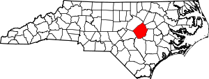 Location within the U.S. state of North Carolina | |
 North Carolina's location within the U.S. | |
| Coordinates: 35°31′N 78°22′W | |
| Country | |
| State | |
| Founded | 1746 |
| Named for | Gabriel Johnston |
| Seat | Smithfield |
| Largest town | Clayton |
| Area | |
| • Total | 796 sq mi (2,060 km2) |
| • Land | 791 sq mi (2,050 km2) |
| • Water | 4.2 sq mi (11 km2) 0.5% |
| Time zone | UTC−5 (Eastern) |
| • Summer (DST) | UTC−4 (EDT) |
| ZIP Codes | 27501, 27504, 27520, 27524, 27527, 27529, 27542, 27555, 27557, 27568, 27569, 27576, 27577, 27591, 27592, 27597, 27603, 28334, 28366 |
| Area code | 919, 984 |
| Congressional district | 13th |
| Website | www |
Johnston County is included in the Raleigh, NC Metropolitan Statistical Area, which is also included in the Raleigh-Durham-Chapel Hill, NC Combined Statistical Area, which has a population of 1,998,808 as of U.S. Census 2012 Population Estimates.[3]
History
The county was formed in 1746 from Craven County. It was named for Gabriel Johnston, Governor of North Carolina from 1734 to 1752.[4] In 1752 parts of Johnston County, Bladen County, and Granville County were combined to form Orange County. In 1758 the eastern part of Johnston County became Dobbs County. In 1770 parts of Johnston County, Cumberland County, and Orange County were combined to form Wake County. Finally, in 1855 parts of Johnston County, Edgecombe County, Nash County, and Wayne County were combined to form Wilson County.
Most early growers in Johnston County were subsistence farmers. A few grew tobacco as a cash crop or reared pigs and cattle, which were sold in Virginia. Smithfield was the westernmost freight port on the Neuse River, and in 1770 the colonial government erected a tobacco warehouse there to store the crop before it was shipped out. Eli Whitney's cotton gin was introduced in the county in about 1804, leading cotton to become the area's leading cash crop. Production for sale at markets remained low before the 1850s due to poor transportation links with other parts of the state. In 1856 the North Carolina Railroad was completed, connecting Johnston County with major urban areas. As result, farming for sale increased, lumber and turpentine industries developed, and the towns of Princeton, Pine Level, Selma, and Clayton were eventually created. About 1,500 Johnstonian men fought in the American Civil War, of whom about a third died. Lingering political tensions and the emancipation of slaves created social and economic turmoil. The new state constitution of 1868 created the county's first townships, which were altered up until 1913.[5] In 1886 the "Short-Cut" line of the Wilmington and Weldon Railroad was laid through Johnston, eventually giving rise to the towns of Kenly, Micro, Four Oaks, and Benson.[6]
The Panic of 1893 caused cotton prices to sharply decline, leading area farmers to switch to bright leaf tobacco as their primary cash crop. A new tobacco market was established in Smithfield in 1898, and the county's first bank was created. Within several years, cotton mills were erected in Smithfield, Clayton, and Selma. During World War I, a brief surge in tobacco and cotton prices brought a boom to the local economy. As a result, the county embarked on a school-construction campaign and consolidated all public schools under a single county system.[7] In the 1920s the state built the county's first two paved highways, and shortly thereafter many towns began paving their main streets.[8] While local commerce enjoyed significant success during the decade, area farmers struggled due to drops in tobacco and cotton prices. The Wall Street Crash of 1929 and ensuing Great Depression caused all banks in the county close.[7] Following the passage of a state bond issue in 1949, most roads in the county and town streets were paved.[9]
Geography

According to the U.S. Census Bureau, the county has a total area of 796 square miles (2,060 km2), of which 791 square miles (2,050 km2) is land and 4.2 square miles (11 km2) (0.5%) is water.[10]
State and local protected areas
- Bentonville Battlefield State Historic Site
- Clemmons Educational State Forest (part)
- Flower Hill Nature Preserve (part)
- Howell Woods Environmental Learning Center
- Wild Bills Western Town- Shadowhawk
Major water bodies
- Black Creek
- Buckhorn Reservoir
- Buffalo Creek
- Holts Lake
- Little Creek
- Little River (Neuse River tributary)
- Middle Creek
- Mingo Swamp (South River tributary)
- Moccasin Creek
- Neuse River
- Sassarixa Swamp
- Snipers Creek
- Swift Creek
Adjacent counties
- Nash County - northeast
- Wilson County - east
- Wayne County - southeast
- Sampson County - south
- Harnett County - southwest
- Wake County - northwest
Major highways
 I-40
I-40
 Future I-42 (Concurrency with US 70)
 I-95
I-95

 I-540 / NC 540 Toll
 Future I-587 (Concurrency with US 264)
 US 70
US 70 US 70 Alt.
 US 70 Bus.
 US 301
 US 701
 US 264 Alt.
 NC 27
NC 27 NC 39
NC 39 NC 42
NC 42 NC 50
NC 50 NC 55
NC 55 NC 96
NC 96 NC 210
 NC 222
 NC 231
 NC 242
Major infrastructure
- Johnston Regional Airport (JNX/KJNX)
- Selma Union Depot
Demographics
| Historical population | |||
|---|---|---|---|
| Census | Pop. | %± | |
| 1790 | 5,691 | — | |
| 1800 | 6,301 | 10.7% | |
| 1810 | 6,867 | 9.0% | |
| 1820 | 9,607 | 39.9% | |
| 1830 | 10,938 | 13.9% | |
| 1840 | 10,599 | −3.1% | |
| 1850 | 13,726 | 29.5% | |
| 1860 | 15,656 | 14.1% | |
| 1870 | 16,897 | 7.9% | |
| 1880 | 23,461 | 38.8% | |
| 1890 | 27,239 | 16.1% | |
| 1900 | 32,250 | 18.4% | |
| 1910 | 41,401 | 28.4% | |
| 1920 | 48,998 | 18.3% | |
| 1930 | 57,621 | 17.6% | |
| 1940 | 63,798 | 10.7% | |
| 1950 | 65,906 | 3.3% | |
| 1960 | 62,936 | −4.5% | |
| 1970 | 61,737 | −1.9% | |
| 1980 | 70,599 | 14.4% | |
| 1990 | 81,306 | 15.2% | |
| 2000 | 121,965 | 50.0% | |
| 2010 | 168,878 | 38.5% | |
| 2020 | 215,999 | 27.9% | |
| 2021 (est.) | 226,504 | [11] | 4.9% |
| U.S. Decennial Census[12] 1790-1960[13] 1900-1990[14] 1990-2000[15] 2010-2013[16] 2020[1] | |||
2020 census
| Race | Number | Percentage |
|---|---|---|
| White (non-Hispanic) | 136,464 | 63.18% |
| Black or African American (non-Hispanic) | 33,041 | 15.3% |
| Native American | 880 | 0.41% |
| Asian | 1,831 | 0.85% |
| Pacific Islander | 71 | 0.03% |
| Other/Mixed | 9,312 | 4.31% |
| Hispanic or Latino | 34,400 | 15.93% |
As of the 2020 United States census, there were 215,999 people, 73,567 households, and 53,743 families residing in the county.
2000 census
As of the census[18] of 2000, there were 121,965 people, 46,595 households, and 33,688 families residing in the county. The population density was 154 people per square mile (59/km2). There were 50,196 housing units at an average density of 63 per square mile (24/km2). The racial makeup of the county was 78.09% White, 15.65% Black or African American, 0.41% Native American, 0.30% Asian, 0.04% Pacific Islander, 4.53% from other races, and 0.99% from two or more races. 7.74% of the population were Hispanic or Latino of any race.
There were 46,595 households, out of which 35.40% had children under the age of 18 living with them, 57.80% were married couples living together, 10.60% had a female householder with no husband present, and 27.70% were non-families. 23.10% of all households were made up of individuals, and 8.60% had someone living alone who was 65 years of age or older. The average household size was 2.58 and the average family size was 3.02.
In the county, the population was spread out, with 26.10% under the age of 18, 8.10% from 18 to 24, 34.20% from 25 to 44, 21.70% from 45 to 64, and 9.80% who were 65 years of age or older. The median age was 34 years. For every 100 females there were 98.70 males. For every 100 females age 18 and over, there were 96.30 males.
The median income for a household in the county was $40,872, and the median income for a family was $48,599. Males had a median income of $33,008 versus $25,582 for females. The per capita income for the county was $18,788. About 8.90% of families and 12.80% of the population were below the poverty line, including 16.00% of those under age 18 and 19.40% of those age 65 or over.
Law and Government
The county is governed by the Johnston County Board of Commissioners, a seven-member board of County Commissioners, elected to serve four-year terms. The commissioners enact policies such as establishment of the property tax rate, regulation of land use and zoning outside municipal jurisdictions, and adoption of the annual budget. Commissioners generally meet each month.[19]
Current (2019) members of the Johnston County Board of Commissioners are:[20]
- Ted G. Godwin, Chairman
- Chad M. Stewart, Vice Chairman
- Jeffrey P. Carver
- Larry Wood
- Tony Braswell
- Patrick E. Harris
- R.S. "Butch" Lawter, Jr.
Rick Hester is the County Manager.
Johnston County is a member of the regional Triangle J Council of Governments. Johnston County 911 is the first 911 Agency in North Carolina to hold "Tri Accreditation" from the National Academies of Emergency Dispatch in Fire, Police, and EMD Protocols.
Politics
For most of the time after the Civil War, Johnston County was a classic Solid South county, going Democratic in all but three elections from 1880 to 1964. However, from 1968 onward it has turned increasingly Republican, with the only breaks in this tradition being its support for third-party candidate George Wallace in 1968 and for Democrat Jimmy Carter in 1976. Carter's unsuccessful bid for reelection in 1980 is the last time that a Democrat has managed even 40 percent of the county's vote.
| Year | Republican | Democratic | Third party | |||
|---|---|---|---|---|---|---|
| No. | % | No. | % | No. | % | |
| 2020 | 68,353 | 61.38% | 41,257 | 37.05% | 1,747 | 1.57% |
| 2016 | 54,372 | 63.29% | 28,362 | 33.01% | 3,175 | 3.70% |
| 2012 | 48,427 | 63.15% | 27,290 | 35.58% | 974 | 1.27% |
| 2008 | 43,622 | 61.42% | 26,795 | 37.73% | 600 | 0.84% |
| 2004 | 36,903 | 67.89% | 17,266 | 31.76% | 188 | 0.35% |
| 2000 | 27,212 | 66.12% | 13,704 | 33.30% | 239 | 0.58% |
| 1996 | 18,704 | 58.23% | 11,175 | 34.79% | 2,240 | 6.97% |
| 1992 | 15,418 | 48.67% | 11,284 | 35.62% | 4,977 | 15.71% |
| 1988 | 15,563 | 63.97% | 8,717 | 35.83% | 49 | 0.20% |
| 1984 | 16,210 | 67.32% | 7,833 | 32.53% | 37 | 0.15% |
| 1980 | 10,444 | 51.26% | 9,601 | 47.12% | 331 | 1.62% |
| 1976 | 8,511 | 45.08% | 10,301 | 54.56% | 67 | 0.35% |
| 1972 | 14,272 | 79.24% | 3,488 | 19.37% | 251 | 1.39% |
| 1968 | 6,764 | 33.05% | 4,492 | 21.95% | 9,212 | 45.01% |
| 1964 | 7,523 | 42.15% | 10,326 | 57.85% | 0 | 0.00% |
| 1960 | 6,660 | 40.18% | 9,914 | 59.82% | 0 | 0.00% |
| 1956 | 4,893 | 33.18% | 9,852 | 66.82% | 0 | 0.00% |
| 1952 | 5,429 | 35.19% | 9,997 | 64.81% | 0 | 0.00% |
| 1948 | 3,211 | 24.71% | 9,188 | 70.69% | 598 | 4.60% |
| 1944 | 4,423 | 34.81% | 8,282 | 65.19% | 0 | 0.00% |
| 1940 | 4,192 | 29.59% | 9,976 | 70.41% | 0 | 0.00% |
| 1936 | 4,339 | 27.83% | 11,253 | 72.17% | 0 | 0.00% |
| 1932 | 3,887 | 28.77% | 9,574 | 70.86% | 50 | 0.37% |
| 1928 | 7,696 | 60.42% | 5,041 | 39.58% | 0 | 0.00% |
| 1924 | 4,910 | 51.20% | 4,656 | 48.56% | 23 | 0.24% |
| 1920 | 5,588 | 48.10% | 6,030 | 51.90% | 0 | 0.00% |
| 1916 | 2,857 | 45.17% | 3,468 | 54.83% | 0 | 0.00% |
| 1912 | 1,335 | 25.80% | 2,757 | 53.28% | 1,083 | 20.93% |
| 1908 | 2,827 | 52.16% | 2,593 | 47.84% | 0 | 0.00% |
| 1904 | 1,553 | 37.65% | 2,572 | 62.35% | 0 | 0.00% |
| 1900 | 1,997 | 38.64% | 3,154 | 61.03% | 17 | 0.33% |
| 1896 | 1,824 | 35.29% | 3,343 | 64.67% | 2 | 0.04% |
| 1892 | 1,036 | 21.62% | 3,135 | 65.44% | 620 | 12.94% |
| 1888 | 2,129 | 41.52% | 2,992 | 58.35% | 7 | 0.14% |
| 1884 | 1,831 | 39.50% | 2,805 | 60.50% | 0 | 0.00% |
| 1880 | 1,631 | 44.20% | 2,059 | 55.80% | 0 | 0.00% |
Education
Higher education
Johnston County is home to Johnston Community College (JCC), a public, two-year, post-secondary college located in Smithfield. The college has off-campus centers throughout Johnston County.[22]
Primary and secondary education
Public education in Johnston County is served by the Johnston County School District, which has 46 schools and serves more than 35,400 students.[23] In addition, one charter schools and five private schools are located in the county. In 2021, the county school board banned the teaching of critical race theory.[24]
Libraries
The Johnston County Public Affiliated Library system operates six branches throughout the county. The library system keeps books, periodicals and audio books and has recently expanded the selection to include downloadable e-books.[25] The Hocutt-Ellington Memorial Library in Clayton left the Johnston County affiliated library system in 2015.[26]
Culture
The Bentonville Battlefield State Historic Site is the largest Civil War battlefield in North Carolina. The Battle of Bentonville was fought in 1865, and was the only Confederate offensive targeted to stop General Sherman's march through the South.
The Tobacco Farm Life Museum in Kenly has been collecting artifacts and showcasing the heritage of the Eastern North Carolina farmer for over 35 years. The site includes a museum and restored farmstead, blacksmith shop, and one-room school house.[27]
The Ava Gardner Museum, located in Smithfield, contains a collection of artifacts such as scripts, movie posters, costumes and personal belongings of actress Ava Gardner, who was born and raised in Johnston County. The museum holds an annual festival.
The Johnston County Heritage Centers in Smithfield contains county artifacts and genealogical records.[28]
The Johnston County Arts Council promotes arts in the county and its schools.[29] Smithfield is the location of an annual Ava Gardner Festival, which celebrates the life of the actress.[30]
The Meadow community is the location of Meadow Lights, an annual display of Christmas lights.[31]
Media
Radio and Television
Johnston County is located in the Raleigh-Durham radio market, ranked by Nielsen as the 37th largest in the United States. Johnston County's first radio station, WMPM, 1270 AM, in Smithfield, signed on in 1950.[32] The county is also home to WPYB, 1130 AM in Benson, WHPY, 1590 AM in Clayton, WTSB, 1090 AM in Selma, and WKJO, 102.3 FM in Smithfield.
The county is also part of the larger, 23-county Raleigh-Durham-Fayetteville Media marketDesignated Market Area—the nation's 24th-largest. WNGT-CD, (virtual channel 34.1) a Class A low-powered TV station licensed to both Smithfield and Selma. The station began frequency sharing with Raleigh's WRAL-TV in November 2020, greatly expanding its coverage. Goldsboro-licensed CBS affiliate WNCN, virtual channel 17/RF channel 8, originally known as WYED-TV, signed on from studios and a transmitter in Clayton in 1988 before moving to Raleigh studios in 1995.
Newspapers
- Clayton News-Star
- Kenly News
- Four Oaks-Benson News in Review
- Princeton News Leader
- The Selma News
- Pine Level News
- Johnstonian News
- The Daily Record
- The Smithfield Herald
- The Cleveland Post
- The Garner-Cleveland Record
- The News & Observer
Communities

Towns
- Archer Lodge
- Benson
- Clayton (largest town)
- Four Oaks
- Kenly
- Micro
- Pine Level
- Princeton
- Selma
- Smithfield (county seat)
- Wilson's Mills
Townships
- Banner
- Bentonville
- Beulah
- Boon Hill
- Brogden
- Clayton
- Cleveland
- Elevation
- Ingrams
- Meadow
- Micro
- O'Neals
- Pine Level
- Pleasant Grove
- Selma
- Smithfield
- Wilders
- Wilson Mills
Unincorporated communities
- Allens Crossroads
- Bagley
- Blackmans Crossroads
- Cleveland
- Emit
- Flowers
- Grabtown
- Hocutts Crossroads
- Jordan
- McGee Crossroads
- Peacocks Crossroads
- Powhatan
- Spilona
- Stancils Chapel
- West Smithfield
- Willow Spring (part)
See also
- List of counties in North Carolina
- National Register of Historic Places listings in Johnston County, North Carolina
- List of places named after people in the United States
- Johnston United Soccer Association
- North Carolina in the American Civil War
- List of North Carolina state forests
- List of future Interstate Highways
References
- "U.S. Census Bureau QuickFacts: Johnston County, North Carolina". www.census.gov. Retrieved April 25, 2022.
- "Find a County". National Association of Counties. Archived from the original on May 31, 2011. Retrieved June 7, 2011.
- "Population Estimates 2012 Combined Statistical Areas: April 1, 2010 to July 1, 2012". U.S. Census Bureau. Archived from the original on March 17, 2013. Retrieved March 14, 2013.
- Gannett, Henry (1905). The Origin of Certain Place Names in the United States (Report) (2nd ed.). Washington: Government Printing Office. p. 170 – via United States Geological Survey.
- Johnson & Barbour 1997, p. 7.
- Johnson & Barbour 1997, pp. 7–8.
- Johnson & Barbour 1997, p. 8.
- Johnson & Barbour 1997, p. 8, 13.
- Johnson & Barbour 1997, p. 13.
- "2010 Census Gazetteer Files". United States Census Bureau. August 22, 2012. Archived from the original on January 12, 2015. Retrieved January 17, 2015.
- "U.S. Census Bureau QuickFacts: Johnston County, North Carolina". www.census.gov. Retrieved May 31, 2022.
- "U.S. Decennial Census". United States Census Bureau. Retrieved January 17, 2015.
- "Historical Census Browser". University of Virginia Library. Retrieved January 17, 2015.
- Forstall, Richard L., ed. (March 27, 1995). "Population of Counties by Decennial Census: 1900 to 1990". United States Census Bureau. Retrieved January 17, 2015.
- "Census 2000 PHC-T-4. Ranking Tables for Counties: 1990 and 2000" (PDF). United States Census Bureau. April 2, 2001. Retrieved January 17, 2015.
- "State & County QuickFacts". United States Census Bureau. Archived from the original on July 13, 2011. Retrieved October 21, 2013.
- "Explore Census Data". data.census.gov. Retrieved December 23, 2021.
- "U.S. Census website". United States Census Bureau. Retrieved January 31, 2008.
- "Scheduled Board Meetings". www.johnstonnc.com. Retrieved March 16, 2018.
- "Meet the Commissioners". www.johnstonnc.com. Retrieved January 9, 2019.
- Leip, David. "Dave Leip's Atlas of U.S. Presidential Elections". uselectionatlas.org. Retrieved March 16, 2018.
- "Johnston Community College". Archived from the original on September 23, 2019. Retrieved February 4, 2020.
- "District Profile - Johnston County Schools". Archived from the original on February 2, 2017. Retrieved January 26, 2017.
- "North Carolina school board bans critical race theory from its classrooms". TheGuardian.com. October 5, 2021.
- "Johnston County Affiliated Libraries". www.jocolib.org. Retrieved March 16, 2018.
- "Clayton Transition Announcement". Mary Duncan Public Library. March 6, 2015. Retrieved March 16, 2018.
- "Home | Tobacco Farm Life Museum, Inc". Tobacco Farm Life Mu. Retrieved September 22, 2022.
- Mickey (January 28, 2022). "Johnston County Heritage Center Spotlighted In New Video". JoCo Report. Retrieved August 1, 2022.
- "Johnston County Arts Council". Archived from the original on February 11, 2008. Retrieved January 13, 2008.
- "Ava Gardner Festival". www.johnstoncountync.org. Retrieved November 6, 2022.
- "Calendar of Events in Smithfield/Johnston County, NC". www.johnstoncountync.org. September 22, 2022. Retrieved September 22, 2022.
{{cite web}}: CS1 maint: url-status (link) - "Broadcasting Station License Record" (PDF). licensing.fcc.gov. September 22, 2022. Archived from the original (PDF) on June 24, 2021. Retrieved September 22, 2022.
Works cited
- Johnson, K. Todd; Barbour, Durwood (1997). Johnston County. Arcadia Publishing. ISBN 9780752408170.
Further reading
- Johnston County, North Carolina, Court Martial Minutes, 1761-1779. Transcribed by Weynette Parks Haun (1st ed.). 1983. LCCN 83-244254.
{{cite book}}: CS1 maint: others (link) - Marriages of Johnston County, North Carolina, 1762-1868. Compiled by Brent H. Holcomb. Baltimore: Genealogical Publishing Co. 1985. ISBN 0-8063-1120-7. LCCN 85-70012.
{{cite book}}: CS1 maint: others (link) - Sanders, W. M. Jr.; Ragsdale, G. Y. (1922). Johnston County: Economic and Social. University of North Carolina. LCCN 39014760. OCLC 6523398 – via The Smithfield Observer.
External links
- Government
- General information
- Johnston County Heritage Center, with historical photos, online tours and exhibits, timelines, and facts
- Johnston County Visitors Bureau, the official site for visitor information for Johnston County
Places adjacent to Johnston County, North Carolina | ||||||||||||||||
|---|---|---|---|---|---|---|---|---|---|---|---|---|---|---|---|---|
| ||||||||||||||||
| |||||||||||||||||||||||||||||||||


Authority control | |
|---|---|
| General | |
| National libraries | |
| Other |
|
На других языках
[de] Johnston County (North Carolina)
Johnston County[1] ist ein County im Bundesstaat North Carolina der Vereinigten Staaten. Im Jahr 2000 hatte das County 121.965 Einwohner und eine Bevölkerungsdichte von 59 Einwohnern pro Quadratkilometer. Der Verwaltungssitz (County Seat) ist Smithfield, das nach John Smith benannt wurde, der das Land zur Gründung der Stadt stiftete.- [en] Johnston County, North Carolina
[ru] Джонстон (округ, Северная Каролина)
Округ Джонстон (англ. Johnston County) располагается в штате Северная Каролина, США. Официально образован в 1746 году. По состоянию на 2010 год, численность населения составляла 168 878 человек.Другой контент может иметь иную лицензию. Перед использованием материалов сайта WikiSort.org внимательно изучите правила лицензирования конкретных элементов наполнения сайта.
WikiSort.org - проект по пересортировке и дополнению контента Википедии