world.wikisort.org - USA
Wilson County is a county located in the U.S. state of North Carolina. As of the 2020 Census, the population was 78,784.[1] The county seat is Wilson.[2] The county comprises the Wilson Micropolitan Statistical Area, which is also included within the Rocky Mount–Wilson–Roanoke Rapids Combined Statistical Area.
Wilson County | |
|---|---|
County | |
| County of Wilson | |
 Wilson County Courthouse | |
 Seal Logo | |
 Location within the U.S. state of North Carolina | |
 North Carolina's location within the U.S. | |
| Coordinates: 35°42′N 77°55′W | |
| Country | |
| State | |
| Founded | 1855 |
| Named for | Col. Louis D. Wilson |
| Seat | Wilson |
| Largest city | Wilson |
| Area | |
| • Total | 374 sq mi (970 km2) |
| • Land | 368 sq mi (950 km2) |
| • Water | 5.6 sq mi (15 km2) 1.5% |
| Population | |
| • Estimate (2021) | 78,369 |
| • Density | 213/sq mi (82/km2) |
| Time zone | UTC−5 (Eastern) |
| • Summer (DST) | UTC−4 (EDT) |
| ZIP Codes | 27542, 27557, 27803, 27807, 27813, 27822, 27829, 27830, 27851, 27852, 27873, 27878, 27880, 27883, 27888, 27893, 27895, 27896 |
| Area code | 252 |
| Congressional district | 1st |
| Website | www |
History
On February 13, 1855, the North Carolina General Assembly established Wilson County "out of portions of Edgecombe, Johnston, Nash, and Wayne Counties."[3] The county was named for Colonel Louis D. Wilson, U.S. Volunteers, who died of fever while on leave from the state senate during the Mexican–American War.[4]
Wilson Speedway held 12 NASCAR Cup Series races at the county fairgrounds in Wilson between 1951 and 1960. The half mile dirt track operated between 1934 and 1989.
Geography

According to the U.S. Census Bureau, the county has a total area of 374 square miles (970 km2), of which 368 square miles (950 km2) are land and 5.6 square miles (15 km2) (1.5%) are covered by water.[5]
State and local protected site
- Tobacco Farm Life Museum[6]
Major water bodies
- Black Creek
- Buckhorn Reservoir
- Contentnea Creek
- Lake Wilson[7]
- Silver Lake[8]
- Wiggins Mill Reservoir[9]
Adjacent counties
- Nash County – north
- Edgecombe County – northeast
- Pitt County – east
- Greene County – southeast
- Wayne County – south
- Johnston County – southwest
Major highways
 I-95
I-95
 I-587 / Future I-587 (Small section incomplete)
 I-795
I-795 US 117
 US 264
 US 264 Alt.
 US 301
 NC 42
NC 42 NC 58
NC 58 NC 111
 NC 222
 NC 581
Major infrastructure
- Amtrak Thruway (Wilson Station)
- Wilson Industrial Air Center[10]
- Wilson Station
Demographics
| Historical population | |||
|---|---|---|---|
| Census | Pop. | %± | |
| 1860 | 9,720 | — | |
| 1870 | 12,258 | 26.1% | |
| 1880 | 16,064 | 31.0% | |
| 1890 | 18,644 | 16.1% | |
| 1900 | 23,596 | 26.6% | |
| 1910 | 28,269 | 19.8% | |
| 1920 | 36,813 | 30.2% | |
| 1930 | 44,914 | 22.0% | |
| 1940 | 50,219 | 11.8% | |
| 1950 | 54,506 | 8.5% | |
| 1960 | 57,716 | 5.9% | |
| 1970 | 57,486 | −0.4% | |
| 1980 | 63,132 | 9.8% | |
| 1990 | 66,061 | 4.6% | |
| 2000 | 73,814 | 11.7% | |
| 2010 | 81,234 | 10.1% | |
| 2020 | 78,784 | −3.0% | |
| 2021 (est.) | 78,369 | [11] | −0.5% |
| U.S. Decennial Census[12] 1790-1960[13] 1900-1990[14] 1990-2000[15] 2010-2013[16] 2020[17] | |||
2020 census
| Race | Number | Percentage |
|---|---|---|
| White (non-Hispanic) | 36,106 | 45.83% |
| Black or African American (non-Hispanic) | 29,842 | 37.88% |
| Native American | 239 | 0.3% |
| Asian | 900 | 1.14% |
| Pacific Islander | 10 | 0.01% |
| Other/Mixed | 2,663 | 3.38% |
| Hispanic or Latino | 9,024 | 11.45% |
As of the 2020 United States census, there were 78,784 people, 32,384 households, and 19,760 families residing in the county. The population density was 199 people per square mile (77/km2). There were 30,729 housing units at an average density of 83 per square mile (32/km2). There were 28,613 households, out of which 31.90% had children under the age of 18 living with them, 48.10% were married couples living together, 16.50% had a female householder with no husband present, and 30.90% were non-families. 26.40% of all households were made up of individuals, and 10.20% had someone living alone who was 65 years of age or older. The average household size was 2.51 and the average family size was 3.03.
In the county, the population was spread out, with 25.60% under the age of 18, 9.10% from 18 to 24, 28.80% from 25 to 44, 23.60% from 45 to 64, and 12.90% who were 65 years of age or older. The median age was 36 years. For every 100 females there were 91.30 males. For every 100 females age 18 and over, there were 87.20 males.
The median income for a household in the county was $33,116, and the median income for a family was $41,551. Males had a median income of $30,364 versus $21,997 for females. The per capita income for the county was $17,102. About 13.80% of families and 18.50% of the population were below the poverty line, including 24.70% of those under age 18 and 21.30% of those age 65 or over.
Government and politics
Wilson County government is a member of the regional Upper Coastal Plain Council of Governments. It has several law-enforcement agencies:
- Wilson County Sheriff's Office
- Wilson Police Department (City of Wilson)
- Stantonsburg Police Department (Town of Stantonsburg)
- Black Creek Police Department (Town of Black Creek)
- Sharpsburg Police Department (Town of Sharpsburg)
| Year | Republican | Democratic | Third party | |||
|---|---|---|---|---|---|---|
| No. | % | No. | % | No. | % | |
| 2020 | 19,581 | 48.07% | 20,754 | 50.95% | 400 | 0.98% |
| 2016 | 17,531 | 45.97% | 19,663 | 51.56% | 941 | 2.47% |
| 2012 | 17,954 | 45.91% | 20,875 | 53.38% | 280 | 0.72% |
| 2008 | 17,375 | 46.72% | 19,652 | 52.84% | 164 | 0.44% |
| 2004 | 16,264 | 53.26% | 14,206 | 46.52% | 65 | 0.21% |
| 2000 | 13,466 | 54.24% | 11,266 | 45.38% | 94 | 0.38% |
| 1996 | 10,518 | 49.03% | 9,779 | 45.59% | 1,154 | 5.38% |
| 1992 | 10,176 | 44.36% | 10,105 | 44.06% | 2,656 | 11.58% |
| 1988 | 10,997 | 57.11% | 8,214 | 42.65% | 46 | 0.24% |
| 1984 | 12,243 | 59.31% | 8,343 | 40.42% | 57 | 0.28% |
| 1980 | 8,329 | 49.86% | 8,042 | 48.14% | 333 | 1.99% |
| 1976 | 6,795 | 45.05% | 8,209 | 54.42% | 80 | 0.53% |
| 1972 | 12,060 | 73.04% | 4,166 | 25.23% | 286 | 1.73% |
| 1968 | 4,053 | 25.13% | 4,173 | 25.87% | 7,903 | 49.00% |
| 1964 | 5,002 | 40.87% | 7,238 | 59.13% | 0 | 0.00% |
| 1960 | 3,114 | 27.97% | 8,021 | 72.03% | 0 | 0.00% |
| 1956 | 2,830 | 25.36% | 8,328 | 74.64% | 0 | 0.00% |
| 1952 | 2,569 | 22.83% | 8,684 | 77.17% | 0 | 0.00% |
| 1948 | 665 | 9.55% | 6,008 | 86.25% | 293 | 4.21% |
| 1944 | 769 | 10.61% | 6,480 | 89.39% | 0 | 0.00% |
| 1940 | 584 | 6.87% | 7,912 | 93.13% | 0 | 0.00% |
| 1936 | 549 | 6.80% | 7,522 | 93.20% | 0 | 0.00% |
| 1932 | 517 | 7.69% | 6,153 | 91.55% | 51 | 0.76% |
| 1928 | 1,933 | 35.35% | 3,535 | 64.65% | 0 | 0.00% |
| 1924 | 574 | 17.53% | 2,619 | 79.99% | 81 | 2.47% |
| 1920 | 1,374 | 28.21% | 3,496 | 71.79% | 0 | 0.00% |
| 1916 | 730 | 26.24% | 2,052 | 73.76% | 0 | 0.00% |
| 1912 | 82 | 3.44% | 1,741 | 73.03% | 561 | 23.53% |
Communities
City
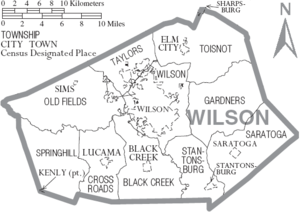
- Wilson (county seat and largest city)
Towns
- Black Creek
- Elm City
- Kenly (part)
- Lucama
- Saratoga
- Sims
- Stantonsburg
- Sharpsburg (part)
Unincorporated communities
- Montclair
- New Hope
- Rock Ridge
Townships
- Black Creek
- Cross Roads
- Gardners
- Old Fields
- Saratoga
- Springhill
- Stantonsburg
- Taylors
- Toisnot
- Wilson
See also
- List of counties in North Carolina
- List of places named after people in the United States
- National Register of Historic Places listings in Wilson County, North Carolina
- Rocky Mount–Wilson Regional Airport, Airport just north of Wilson county in Nash County.
- List of future Interstate Highways
References
- "U.S. Census Bureau QuickFacts: Wilson County, North Carolina". www.census.gov. Retrieved April 21, 2022.
- "Find a County". National Association of Counties. Retrieved June 7, 2011.
- Public Laws of the State of North-Carolina, Passed by the General Assembly, at its Session of 1854–'55: Together with the Comptroller's Statement of Public Revenue and Expenditure. Raleigh: Holden & Wilson. 1855. p. 30. LCCN 83644405 – via Internet Archive.
- Lichtenstein, Gaston (1911). Louis D. Wilson, Mexican War Martyr, also, Thos. H. Hall, Andrew Johnson as he Really was, and, Our Town Common; Four Articles. Richmond, Va.: H. T. Ezekiel. p. 7. OCLC 1127629. OL 14021029M – via Internet Archive.
- "2010 Census Gazetteer Files". United States Census Bureau. August 22, 2012. Archived from the original on January 12, 2015. Retrieved January 20, 2015.
- "Home | Tobacco Farm Life Museum, Inc". Tobacco Farm Life Mu. Retrieved July 27, 2022.
- "Parks & Shelters | Wilson, NC". www.wilsonnc.org. Retrieved July 27, 2022.
- Novak, Steven. "Fish Silver Lake - Wilson County, North Carolina". Lake-Link. Retrieved July 27, 2022.
- "Parks & Shelters | Wilson, NC". www.wilsonnc.org. Retrieved July 27, 2022.
- "Wilson Industrial Air Center | Wilson, NC". www.wilsonnc.org. Retrieved July 18, 2022.
- "U.S. Census Bureau QuickFacts: Wilson County, North Carolina". www.census.gov. Retrieved May 31, 2022.
- "U.S. Decennial Census". United States Census Bureau. Retrieved January 20, 2015.
- "Historical Census Browser". University of Virginia Library. Retrieved January 20, 2015.
- Forstall, Richard L., ed. (March 27, 1995). "Population of Counties by Decennial Census: 1900 to 1990". United States Census Bureau. Retrieved January 20, 2015.
- "Census 2000 PHC-T-4. Ranking Tables for Counties: 1990 and 2000" (PDF). United States Census Bureau. April 2, 2001. Retrieved January 20, 2015.
- "State & County QuickFacts". United States Census Bureau. Retrieved October 30, 2013.
- "U.S. Census Bureau QuickFacts: Wilson County, North Carolina". www.census.gov. Retrieved May 31, 2022.
- "Explore Census Data". data.census.gov. Retrieved December 24, 2021.
- Leip, David. "Dave Leip's Atlas of U.S. Presidential Elections". uselectionatlas.org. Retrieved March 17, 2018.
Further reading
- "Confederate Memorial Day" [Wilson County, North Carolina] (Black & white photoprint). Chapel Hill, N.C.: North Carolina Digital Heritage Center (DigitalNC). c. 1890. 5587. Retrieved December 20, 2016.
External links
 Definitions from Wiktionary
 Media from Commons
 Data from Wikidata
- Official
- General information
 Geographic data related to Wilson County, North Carolina at OpenStreetMap
- Wilson County Genealogical Society
Places adjacent to Wilson County, North Carolina | ||||||||||||||||
|---|---|---|---|---|---|---|---|---|---|---|---|---|---|---|---|---|
| ||||||||||||||||
Municipalities and communities of Wilson County, North Carolina, United States | ||
|---|---|---|
County seat: Wilson | ||
| City | 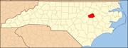 | |
| Towns | ||
| Unincorporated communities |
| |
| Footnotes | ‡This populated place also has portions in an adjacent county or counties | |
| ||
Authority control | |
|---|---|
| General | |
| National libraries | |
| Other | |
На других языках
[de] Wilson County (North Carolina)
Wilson County[1] ist ein County im Bundesstaat North Carolina der Vereinigten Staaten. Der Verwaltungssitz (County Seat) ist Wilson.- [en] Wilson County, North Carolina
[ru] Уилсон (округ, Северная Каролина)
Округ Уилсон (англ. Wilson County) располагается в штате Северная Каролина, США. Официально образован в 1855 году. По состоянию на 2010 год, численность населения составляла 81 234 человека.Другой контент может иметь иную лицензию. Перед использованием материалов сайта WikiSort.org внимательно изучите правила лицензирования конкретных элементов наполнения сайта.
WikiSort.org - проект по пересортировке и дополнению контента Википедии