world.wikisort.org - USA
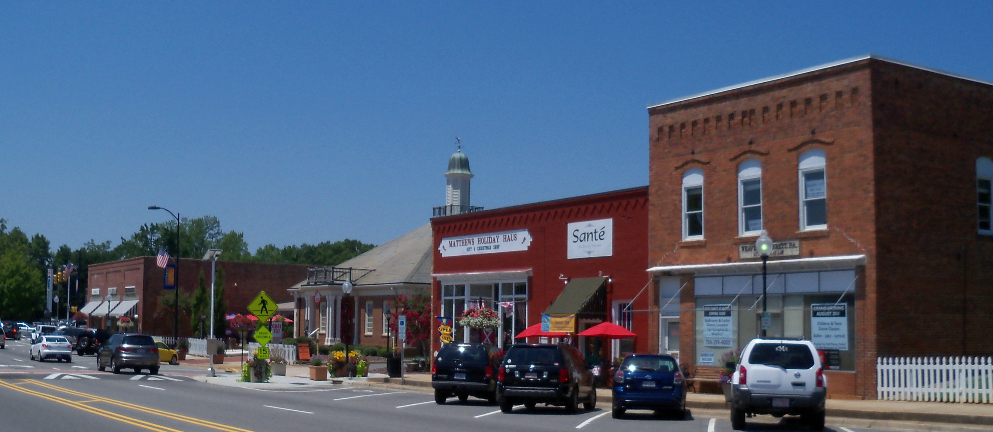
Matthews is a town in southeastern Mecklenburg County, North Carolina, United States. It is a suburb of Charlotte. The population was 27,198 according to the 2010 Census.
Matthews, North Carolina | |
|---|---|
Town | |
 Matthews Town Hall and library | |
 Flag Seal | |
 Location of Matthews, North Carolina | |
| Coordinates: 35°7′1″N 80°42′59″W | |
| Country | United States |
| State | North Carolina |
| County | Mecklenburg and Union |
| Government | |
| • Mayor | John Higdon |
| • Town Manager | Becky Hawke |
| Area | |
| • Total | 17.19 sq mi (44.53 km2) |
| • Land | 17.11 sq mi (44.33 km2) |
| • Water | 0.08 sq mi (0.21 km2) |
| Elevation | 745 ft (227 m) |
| Population (2020) | |
| • Total | 29,435 |
| • Density | 1,719.84/sq mi (664.05/km2) |
| Time zone | UTC−5 (Eastern (EST)) |
| • Summer (DST) | UTC−4 (EDT) |
| ZIP codes | 28104, 28105 |
| Area code | 704 |
| FIPS code | 3741960[2] |
| GNIS feature ID | 2406108[3] |
| Website | Official website |
History
In the early 19th century, the new settlement that would become Matthews was unofficially named Stumptown for the copious amount of tree stumps left from making way for cotton farms. The community's name later changed to Fullwood, named after appointed area postmaster John Miles Fullwood. The establishment of a sawmill and the cotton and timber industry helped Fullwood change into a town. Prior to the first train arriving on December 15, 1874, Fullwood acted as a stagecoach stop between Charlotte and Monroe. The town was incorporated into a municipal corporation in 1879, and was renamed Matthews in honor of Edward Matthews, who was director of the Central Carolina Railroad, which would later become known as the Seaboard Air Line Railroad.[4][5]
Geography
Matthews is located at 35°7′1″N 80°42′59″W (35.116851, −80.716409).[3]
According to the United States Census Bureau, the town has a total area of 17.2 square miles (45 km2), all land.
Matthews is situated approximately 11.0 miles (17.7 km) southeast of uptown Charlotte.
Demographics
| Historical population | |||
|---|---|---|---|
| Census | Pop. | %± | |
| 1880 | 191 | — | |
| 1890 | 335 | 75.4% | |
| 1900 | 378 | 12.8% | |
| 1910 | 396 | 4.8% | |
| 1920 | 310 | −21.7% | |
| 1930 | 454 | 46.5% | |
| 1940 | 486 | 7.0% | |
| 1950 | 589 | 21.2% | |
| 1960 | 609 | 3.4% | |
| 1970 | 783 | 28.6% | |
| 1980 | 1,648 | 110.5% | |
| 1990 | 13,651 | 728.3% | |
| 2000 | 22,127 | 62.1% | |
| 2010 | 27,198 | 22.9% | |
| 2020 | 29,435 | 8.2% | |
| U.S. Decennial Census[6] | |||

2020 census
| Race | Number | Percentage |
|---|---|---|
| White (non-Hispanic) | 20,897 | 70.99% |
| Black or African American (non-Hispanic) | 3,004 | 10.21% |
| Native American | 71 | 0.24% |
| Asian | 1,400 | 4.76% |
| Pacific Islander | 12 | 0.04% |
| Other/Mixed | 1,350 | 4.59% |
| Hispanic or Latino | 2,701 | 9.18% |
As of the 2020 United States census, there were 29,435 people, 12,011 households, and 8,496 families residing in the town.
2006-2008
As of the 2006-2008 American Community Survey, there were 26,901 people, 11,349 households, and 7,904 families in the town. According to the Census Bureau of 2000, the population density was 1,557.1 people per square mile (601.2/km2). There were 138 housing units at an average density of 572.7 per square mile (221.1/km2). According to the 2006-2008 American Community Survey, The racial makeup of the town was 82.3% White, 10.1% African American or Black, 0.3% American Indian or Alaska Native, 3.7% Asian, 0.00% Pacific Islander, 1.8% of other race, and 1.7% from two or more races. Hispanic or Latino of any race were 4.3% of the population.
There were 7,904 households, of which 36.1% had children under the age of 18 living with them, 63.4% were married/couples living together, 7.8% had a female householder with no husband present, and 25.5% were non-families. 22.4% of households were one person and 8.2% were one person aged 65 or older. The average household size was 2.61 and the average family size was 3.08.
The age distribution was 29.9% under the age of 19, 3.2% from 20 to 24, 25.6% from 25 to 44, 30.3% from 45 to 64, and 11% 65 or older. The median age was 40.3 years.
The median household income was $77,981 and the median family income was $88,600. Males had a median income of $65,909 versus $44,665 for females. The per capita income for the town was $35,250. About 2.8% of families and 3.8% of the population were below the poverty line, including 3.6% of those under age 18 and 4.9% of those age 65 or over.
Education
Matthews is in the Charlotte-Mecklenburg Schools system and a small portion is in the Union County Public School system. Schools include Matthews Elementary, Crown Point Elementary, and Elizabeth Lane Elementary; Crestdale Middle; David W. Butler High School. Union County Public Schools include Antioch, Weddington, Wesley Chapel, and Indian Trail Elementaries; Weddington Middle, and Weddington High School. Public charter schools include Matthews Charter Academy, Telra Institute and Socrates Academy. Religious schools nearby include Covenant Day School, Charlotte Christian School, Carmel Christian, Blessed Sacrament Academy, and Greyfriars Classical Academy.
Matthews is served by a branch of the Charlotte Mecklenburg Library.[8] The library is located on the first floor of the Matthews Town Hall and is one of the most active in the system.
Economy
Companies with headquarters in Matthews include:
- Family Dollar Stores, a store chain.[9]
- Harris Teeter, a grocery store chain.
- Pokertek, a gaming device manufacturer.
Sports
Matthews is home to professional soccer club Stumptown Athletic, named after the suburb's nickname. It was founded in 2019 and plays in US Soccer's third division, the National Independent Soccer Association. Its home stadium is the 5,000 capacity Sportsplex at Matthews.
Notable people
- Jamar Adams, NFL safety[10]
- Tyler Barnhardt, actor
- J. Curtis Blackwood Jr., Republican member of the North Carolina General Assembly[11]
- Robert Blanton, NFL strong safety[12]
- Jarrett Boykin, wide receiver in both the NFL and CFL
- Cierra Burdick, WNBA player[13]
- Ty Buttrey, MLB pitcher[14]
- Dion Byrum, football cornerback[15]
- Tricia Cotham, Democratic member of the North Carolina House of Representatives[16]
- Brooklyn Decker, model and actress best known for her appearances in the Sports Illustrated Swimsuit Issue[17]
- Jahwan Edwards, football running back
- Ikem Ekwonu, NFL offensive tackle for the Carolina Panthers
- Riley Ferguson, football quarterback
- Jim Gulley, member of the North Carolina General Assembly[18]
- Tomas Hilliard-Arce, professional soccer player[19]
- Darius Kilgo, NFL defensive tackle and two-time Super Bowl champion
- Jordan Lloyd, winner of the reality TV show Big Brother 11[20] and contestant on Big Brother 13 and The Amazing Race 16
- Jennifer Loven, journalist, former White House press correspondent for the Associated Press (AP)
- Kenneth Moore, NFL wide receiver[21]
- Jerry Reary, NASCAR driver
- Channing Stribling, football cornerback
Sister cities
Matthews is twinned with:
 Sainte-Maxime, Var, France
References
- "ArcGIS REST Services Directory". United States Census Bureau. Retrieved September 20, 2022.
- "Factfinder". census.gov. Archived from the original on 2020-02-11. Retrieved 2010-02-02.
- "Town of Matthews". Geographic Names Information System. United States Geological Survey, United States Department of the Interior.
- Gannett, Henry (1905). The Origin of Certain Place Names in the United States. U.S. Government Printing Office. p. 203.
- "Our History - Matthews, NC". www.matthewsnc.gov. Retrieved 2018-06-19.
- "Census of Population and Housing". Census.gov. Retrieved June 4, 2015.
- "Explore Census Data". data.census.gov. Retrieved 2021-12-20.
- "Matthews branch of the Public Library of Charlotte and Mecklenburg County". Archived from the original on 2008-08-04. Retrieved 2008-10-25.
- "Fortune 500 Companies". Charlotte Chamber Web Site. Retrieved 2008-10-21.
- Jamar Adams Stats. Pro-Football-Reference. Retrieved 18 June 2019.
- Blackwood, Jr., J. Curtis. Our Campaigns. Retrieved 18 June 2019.
- Robert Blanton, Notre Dame, Safety - 247Sports. Retrieved October 27, 2020.
- Cierra Burdick 2011 High School Girls Basketball Profile - ESPN. Retrieved October 27, 2020.
- Ty Buttrey Stats. Baseball-Reference. Retrieved 18 June 2019.
- Dion Bryum Stats. Pro-Football-Reference. Retrieved 18 June 2019.
- Ferris, Jennifer. (April 16, 2015) Smoking Rule Tabled. North Carolina Health News. Retrieved 18 June 2019.
- "Mecklenburg County Special Olympians to represent NC in national tourney | WCNC.com Charlotte". Archived from the original on 2012-03-09. Retrieved 2010-07-21.
- Henderson, Bruce. (May 21, 2014). Former N.C. Rep. Jim Gulley dies. The Herald. Retrieved October 27, 2020.
- Tomas Hillard-Arce | MLSsoccer.com. Retrieved October 28, 2020.
- Yates, James (September 16, 2009). "'Big Brother 11': Jordan Lloyd wins, goes on CBS 'Early Show'". Staten Island Advance. Advance Publications. Retrieved September 16, 2009.
- David W. Butler (Matthews, NC) Alumni Pro Stats. Pro-Football-Reference. Retrieved October 27, 2020.
External links
Charlotte metropolitan area | |||||||||||||
|---|---|---|---|---|---|---|---|---|---|---|---|---|---|
|  | ||||||||||||
|
| |||||||||||||
Municipalities and communities of Mecklenburg County, North Carolina, United States | ||
|---|---|---|
County seat: Charlotte | ||
| City |  | |
| Towns | ||
| Unincorporated communities | ||
| Footnotes | ‡This populated place also has portions in an adjacent county or counties | |
| ||
Authority control | |
|---|---|
| General | |
| National libraries | |
На других языках
[de] Matthews (North Carolina)
Matthews ist eine Kleinstadt (Town) im Mecklenburg County des US-Bundesstaates North Carolina. Die Einwohnerzahl beträgt 33.138 (Stand 2019). Matthews ist Teil der Metropolregion Charlotte und eine Vorstadt.- [en] Matthews, North Carolina
[fr] Matthews (Caroline du Nord)
La ville de Matthews est dans le comté de Comté de Mecklenburg (Caroline du Nord), situé en Caroline du Nord, aux États-Unis.[it] Matthews (Carolina del Nord)
Matthews è una città degli Stati Uniti d'America, situata nella Contea di Mecklenburg nello Stato della Carolina del Nord.[ru] Мэтьюз (Северная Каролина)
Мэтьюз (англ. Matthews) — город в штате Северная Каролина, США[4].Другой контент может иметь иную лицензию. Перед использованием материалов сайта WikiSort.org внимательно изучите правила лицензирования конкретных элементов наполнения сайта.
WikiSort.org - проект по пересортировке и дополнению контента Википедии