world.wikisort.org - France
Tournehem-sur-la-Hem (West Flemish: Doornem) is a commune in the Pas-de-Calais department in the Hauts-de-France region of France.
Tournehem-sur-la-Hem
Doornem | |
|---|---|
Commune | |
 Town fortifications | |
 Coat of arms | |
Location of Tournehem-sur-la-Hem  | |
 Tournehem-sur-la-Hem  Tournehem-sur-la-Hem | |
| Coordinates: 50°48′26″N 2°02′57″E | |
| Country | France |
| Region | Hauts-de-France |
| Department | Pas-de-Calais |
| Arrondissement | Saint-Omer |
| Canton | Saint-Omer |
| Intercommunality | Pays de Saint-Omer |
| Government | |
| • Mayor (2020–2026) | Jean Paul Vasseur[1] |
| Area 1 | 18.14 km2 (7.00 sq mi) |
| Population | 1,400 |
| • Density | 77/km2 (200/sq mi) |
| Time zone | UTC+01:00 (CET) |
| • Summer (DST) | UTC+02:00 (CEST) |
| INSEE/Postal code | 62827 /62890 |
| Elevation | 22–174 m (72–571 ft) (avg. 39 m or 128 ft) |
| 1 French Land Register data, which excludes lakes, ponds, glaciers > 1 km2 (0.386 sq mi or 247 acres) and river estuaries. | |
Geography
Tournehem-sur-la-Hem is located 10 miles (16 km) northwest of Saint-Omer, at the D217 and D218 road junction, on the banks of the river Hem.
Population
| Year | 1962 | 1968 | 1975 | 1982 | 1990 | 1999 | 2006 |
|---|---|---|---|---|---|---|---|
| Population | 831 | 835 | 965 | 1018 | 1069 | 1219 | 1253 |
| From the year 1962 on: No double counting—residents of multiple communes (e.g. students and military personnel) are counted only once. | |||||||
Places of interest
- The church of Saint Médard, dating from the fifteenth, seventeenth and eighteenth century, now a historical monument.[3]
- The ruins of the 12th-century château which was destroyed in 1542.
- The area also has some windmill's, such as the Moulin à vent Bacquet.
- The eighteenth-century château at Guémy.
- The church of Notre-Dame at Guémy, dating from the eighteenth century.
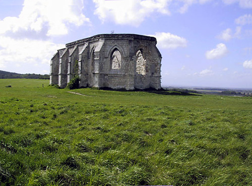
- The ruins of the 13th-century chapel of Guémy on Saint Louis Mount, which has extensive views of the area
See also
References
- "Répertoire national des élus: les maires". data.gouv.fr, Plateforme ouverte des données publiques françaises (in French). 2 December 2020. Retrieved 7 December 2020.
- "Populations légales 2019". The National Institute of Statistics and Economic Studies. 29 December 2021.
- Base Mérimée: PA00108434, Ministère français de la Culture. (in French)
External links
| Wikimedia Commons has media related to Tournehem-sur-la-Hem. |
- Regional Tourist Office website (in French)
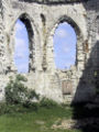 The ruins of the chapel
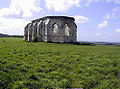 at Guémy

This Pas-de-Calais geographical article is a stub. You can help Wikipedia by expanding it. |
Текст в блоке "Читать" взят с сайта "Википедия" и доступен по лицензии Creative Commons Attribution-ShareAlike; в отдельных случаях могут действовать дополнительные условия.
Другой контент может иметь иную лицензию. Перед использованием материалов сайта WikiSort.org внимательно изучите правила лицензирования конкретных элементов наполнения сайта.
Другой контент может иметь иную лицензию. Перед использованием материалов сайта WikiSort.org внимательно изучите правила лицензирования конкретных элементов наполнения сайта.
2019-2026
WikiSort.org - проект по пересортировке и дополнению контента Википедии
WikiSort.org - проект по пересортировке и дополнению контента Википедии