world.wikisort.org - France
Hauts-de-France (French pronunciation: [o də fʁɑ̃s] (![]() listen); Picard: Heuts-d'Franche; lit. 'Heights of France', also Upper France[2]) is the northernmost region of France, created by the territorial reform of French regions in 2014, from a merger of Nord-Pas-de-Calais and Picardy. Its prefecture is Lille. The new region came into existence on 1 January 2016, after regional elections in December 2015.[3] The Conseil d'État approved Hauts-de-France as the name of the region on 28 September 2016, effective the following 30 September.[4][5]
listen); Picard: Heuts-d'Franche; lit. 'Heights of France', also Upper France[2]) is the northernmost region of France, created by the territorial reform of French regions in 2014, from a merger of Nord-Pas-de-Calais and Picardy. Its prefecture is Lille. The new region came into existence on 1 January 2016, after regional elections in December 2015.[3] The Conseil d'État approved Hauts-de-France as the name of the region on 28 September 2016, effective the following 30 September.[4][5]
Hauts-de-France
| |
|---|---|
 Quai Belu in Amiens | |
 Flag Coat of arms | |
 | |
| Coordinates: 49.9206°N 2.7030°E | |
| Country | |
| Prefecture | Lille |
| Departments | 5
|
| Government | |
| • President of the Regional Council | Xavier Bertrand (LR) |
| Area | |
| • Total | 31,813 km2 (12,283 sq mi) |
| • Rank | 9th |
| Population | |
| • Total | 6,004,947 |
| • Density | 190/km2 (490/sq mi) |
| Time zone | UTC+01:00 (CET) |
| • Summer (DST) | UTC+02:00 (CEST) |
| ISO 3166 code | FR-HDF |
| GDP (PPP) (2016) | Ranked 5th (13th per capita) |
| Total | €176 billion (US$195 billion) |
| Per capita | €29,215 (US$32,363) |
| NUTS Region | FRE |
| Website | www |
With 6,009,976 inhabitants (as of 1 January 2015) and a population density of 189 inhabitants/km2, it is the third most populous region in France and the second most densely populated in metropolitan France after its southern neighbour Île-de-France. It is bordered by Belgium to the north.
Toponymy
The region's interim name Nord-Pas-de-Calais-Picardie was a hyphenated placename, created by hyphenating the merged regions' names—Nord-Pas-de-Calais and Picardie—in alphabetical order.[6]
On 14 March 2016, well ahead of the 1 July deadline, the regional council decided on Hauts-de-France as the region's permanent name.[4][6] The provisional name of the region was retired on 30 September 2016, when the new name of the region, Hauts-de-France, took effect.[5]
Geography
The region covers an area of more than 31,813 km2 (12,283 sq mi). It borders Belgium (Flanders and Wallonia) to the northeast, the North Sea to the north, the English Channel to the west, as well as the French regions of Grand Est to the east-southeast, Île-de-France to the south, and Normandy to the west-southwest. It is connected to the United Kingdom (England) via the Channel Tunnel.
Departments
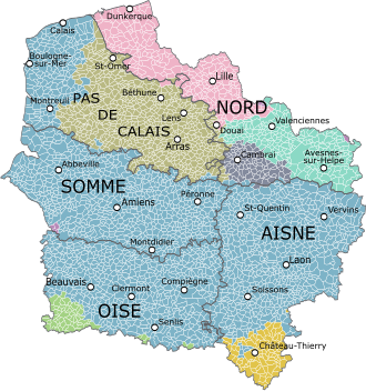
Hauts-de-France comprises five departments: Aisne, Nord, Oise, Pas-de-Calais, and Somme.
Major communities
- Lille (227,560; region prefecture; surrounding area is home to over 1.5 million inhabitants)
- Amiens (133,448)
- Roubaix (94,713)
- Tourcoing (91,923)
- Dunkirk (90,995)
- Calais (72,589)
- Villeneuve-d'Ascq (62,308)
- Saint-Quentin (55,978)
- Beauvais (54,289)
- Valenciennes (42,691)
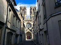 Notre Dame de Laon, France
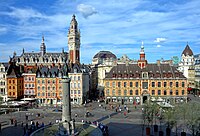

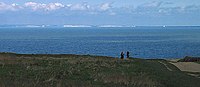 View of the White Cliffs of Dover, England, from Cap Gris Nez, France


Economy
The Gross domestic product (GDP) of the region was 161.7 billion euros in 2018, accounting for 6.9% of French economic output. GDP per capita adjusted for purchasing power was 24,200 euros or 80% of the EU27 average in the same year. The GDP per employee was 101% of the EU average.[7]
Linen weaving
The region was a pivotal centre of mulquinerie.
See also
- Battle of Vimy Ridge
- Canadian National Vimy Memorial
- Nord-Pas-de-Calais
- Picardy
- Regional Council of the Hauts-de-France
- Regions of France
References
- "Téléchargement du fichier d'ensemble des populations légales en 2019". The National Institute of Statistics and Economic Studies. 29 December 2021.
- "The North: Upper France". francerevisited.com.
- "La carte à 13 régions définitivement adoptée" [The 13-region map finally adopted]. Le Monde (in French). Agence France-Presse. 17 December 2014. Retrieved 13 January 2015.
- "La Région a voté et s'appelle désormais Hauts-de-France" [The region has voted and is now called Hauts-de-France]. La Voix du Nord (in French). Lille. 15 March 2016. Retrieved 15 March 2016.
- Décret n° 2016-1265 du 28 septembre 2016 portant fixation du nom et du chef-lieu de la région Hauts-de-France (in French)
- Loi n° 2015–29 du 16 janvier 2015 relative à la délimitation des régions, aux élections régionales et départementales et modifiant le calendrier électoral (in French)
- "Regional GDP per capita ranged from 30% to 263% of the EU average in 2018". Eurostat.
{{cite web}}: CS1 maint: url-status (link)
External links
- Official website
 (in French)
 - Merger of the regions – France 3
Authority control | |
|---|---|
| General | |
| National libraries | |
| Other |
|
На других языках
[de] Hauts-de-France
Hauts-de-France [.mw-parser-output .IPA a{text-decoration:none}o d(ə) fʁãs] ist eine französische Region, die am 1. Januar 2016 durch den Zusammenschluss der bisherigen Regionen Nord-Pas-de-Calais und Picardie entstand. Von Januar bis September 2016 trug sie den vorläufigen Namen Nord-Pas-de-Calais-Picardie.- [en] Hauts-de-France
[ru] О-де-Франс
О-де-Франс (фр. Hauts-de-France[2], буквально — Верхняя Франция), с 1 января по 30 сентября 2016 года Нор — Па-де-Кале́ — Пика́рдия (фр. Nord-Pas-de-Calais-Picardie) — регион Франции, созданный в соответствии с территориальной реформой французских регионов 2014 года[3] в результате объединения регионов Нор — Па-де-Кале и Пикардия. Датой образования нового региона считается 1 января 2016 года[4]. 28 сентября 2016 года Государственный совет Франции вынес решение о переименовании региона с 30 сентября[2].Другой контент может иметь иную лицензию. Перед использованием материалов сайта WikiSort.org внимательно изучите правила лицензирования конкретных элементов наполнения сайта.
WikiSort.org - проект по пересортировке и дополнению контента Википедии