world.wikisort.org - France
Saint-Quentin (French: [sɛ̃ kɑ̃tɛ̃]; Picard: Saint-Kintin; older Dutch: Sint-Kwintens [sɪnt ˈkʋɪntəns]) is a city in the Aisne department, Hauts-de-France, northern France. It has been identified as the Augusta Veromanduorum of antiquity. It is named after Saint Quentin of Amiens, who is said to have been martyred there in the 3rd century.
This article needs additional citations for verification. (August 2011) |
Saint-Quentin
| |
|---|---|
Subprefecture | |
 Town hall | |
 Coat of arms | |
Location of Saint-Quentin  | |
 Saint-Quentin  Saint-Quentin | |
| Coordinates: 49°50′55″N 3°17′11″E | |
| Country | France |
| Region | Hauts-de-France |
| Department | Aisne |
| Arrondissement | Saint-Quentin |
| Canton | Saint-Quentin-1, 2 and 3 |
| Intercommunality | CA Saint-Quentinois |
| Government | |
| • Mayor (2020–2026) | Frédérique Macarez[1] |
| Area 1 | 22.56 km2 (8.71 sq mi) |
| Population | 53,570 |
| • Density | 2,400/km2 (6,200/sq mi) |
| Time zone | UTC+01:00 (CET) |
| • Summer (DST) | UTC+02:00 (CEST) |
| INSEE/Postal code | 02691 /02100 |
| Elevation | 68–125 m (223–410 ft) (avg. 74 m or 243 ft) |
| 1 French Land Register data, which excludes lakes, ponds, glaciers > 1 km2 (0.386 sq mi or 247 acres) and river estuaries. | |
Administration
Saint-Quentin is a sub-prefecture of Aisne. Although Saint-Quentin is by far the largest city in Aisne, the capital is the third-largest city, Laon.
Mayors
The mayor of Saint-Quentin is Frédérique Macarez,[1] a member of the centre-right LR Party.
| From | To | Name | Party |
|---|---|---|---|
| 2016 | present | Frédérique Macarez | LR |
| 2010 | 2016 | Xavier Bertrand | UMP |
| 1995 | 2010 | Pierre André | UMP |
| 1989 | 1995 | Daniel Le Meur | PCF |
| 1983 | 1989 | Jacques Braconnier | RPR |
| 1977 | 1983 | Daniel Le Meur | PCF |
| 1966 | 1977 | Jacques Braconnier | UDR |
History
The city was founded by the Romans, in the Augustean period, to replace the oppidum of Vermand (11 km away) as the capital of Viromandui (Celtic Belgian people who occupied the region). It received the name "Augusta Viromanduorum", Augusta of the Viromandui, in honor of the emperor Augustus. The site is that of a ford across the River Somme. During the late Roman period, it is possible that the civitas capital was transferred back to Vermand (whose name comes from Veromandis); almost nothing relating to the fourth century has been found in Saint-Quentin.[citation needed]
During the early Middle Ages, a major monastery, now the Basilica of Saint-Quentin, developed, based on pilgrimage to the tomb of Quentin, a Roman Christian who came to evangelize the region and was martyred in Augusta, giving rise to a new town which was named after him.
From the 9th century, Saint-Quentin was the capital of Vermandois County. From the 10th century, the counts of Vermandois (descendants of the Carolingian, then Capetian families) were very powerful. The city grew rapidly: the "bourgeois" organized themselves and obtained, in the second half of the 12th century (a very early date), a municipal charter, which guaranteed their commune a large degree of autonomy.
At the beginning of the 13th century, Saint-Quentin entered the royal domain. At that time, it was a thriving city, based on its wool textile industry (city “drapante”). It was also a centre of commerce boosted by its position on the border of the kingdom of France, between the Champagne fairs and the cities of Flanders (wine exportation, etc.): it had an important annual fair. It also benefited from its location in the heart of a rich agricultural region (trade of grain and “guède” (woad), a high-value blue dye).
From the 14th century, Saint-Quentin suffered from this strategic position: it endured the French-English wars (Hundred Years' War). In the 15th century, the city was disputed between the king of France and the dukes of Burgundy (it is one of the "cities of the Somme"). Ravaged by the plague on several occasions, its population decreased, while its economy was in crisis: its fair was increasingly irrelevant, and agricultural production diminished. The declining textile industry turned to the production of linen canvas. Meanwhile, the city faced major expenses to maintain its fortifications and armed troops.
Between the end of the 15th century and the mid-17th century, this strategic position was the cause of frequent misfortune. In 1557, a siege by the Spanish army (as part of the battle of Saint-Quentin) ended with the looting of the city and its desertion for two years. Given back to France in 1559, it underwent intense fortification work: the medieval wall, redesigned several times, was protected by many new advanced fortifications. Two districts were razed to make way for them. In the mid-17th century, the city escaped the sieges, but suffered the horrors of wars ravaging the Picardy region, accompanied by the plague (in 1636, 3,000 people died, out of perhaps 10,000 inhabitants) and famine.
In the second half of the 17th century, the conquests of Louis XIV moved the border away from Saint- Quentin, and it lost much of its strategic role. At the end of the 16th century, its textile production specialized in fine flax canvas (batiste and lawn). This brought prosperity, particularly in the 18th century, when these textiles were exported across Europe and the Americas.
During the First French Empire, difficulties in the export market brought economic decline. At the request of the municipality, Napoleon ordered the razing of the fortifications, to allow the city to grow beyond its old boundaries. In 1814-1815, Saint-Quentin was occupied by the Russian army, but without any damage.
In the 19th century, Saint-Quentin developed into a thriving industrial city, thanks to entrepreneurs constantly on the lookout for new technologies. Textiles and mechanical devices were foremost among a wide variety of products.
In 1870, during the Franco-Prussian War, the population repelled the Prussians on October 8, but the city fell during the second offensive. The hopeless but heroic action had national repercussions: Saint-Quentin was decorated with the Legion of Honour. In 1871, on January 19, the French army was defeated near the town.

The First World War hit Saint-Quentin very hard. In September 1914, the city was overrun; it endured a harsh occupation. From 1916, it lay at the heart of the war zone, because the Germans had integrated it into the Hindenburg Line. After the evacuation of the population in March, the town was systematically looted and industrial equipment removed or destroyed. The fighting destroyed it: 80% of buildings (including the Basilica of Saint-Quentin) were damaged.
Despite national support, the reconstruction process was long, and the city struggled to regain its pre-1914 dynamism. The 1911 population of 55,000 was achieved again only in the mid-1950s, in the context of general economic expansion. This prosperity continued until the mid-1970s, when the French textile industry began to suffer through competition from developing countries.
Climate
| Climate data for Saint-Quentin, Aisne (1981–2010 averages) | |||||||||||||
|---|---|---|---|---|---|---|---|---|---|---|---|---|---|
| Month | Jan | Feb | Mar | Apr | May | Jun | Jul | Aug | Sep | Oct | Nov | Dec | Year |
| Record high °C (°F) | 14.9 (58.8) |
19.2 (66.6) |
23.1 (73.6) |
27.8 (82.0) |
30.3 (86.5) |
36.6 (97.9) |
35.9 (96.6) |
37.9 (100.2) |
31.8 (89.2) |
27.8 (82.0) |
19.6 (67.3) |
16.8 (62.2) |
37.9 (100.2) |
| Average high °C (°F) | 5.5 (41.9) |
6.6 (43.9) |
10.6 (51.1) |
14.0 (57.2) |
17.9 (64.2) |
20.7 (69.3) |
23.4 (74.1) |
23.4 (74.1) |
19.6 (67.3) |
14.9 (58.8) |
9.3 (48.7) |
5.9 (42.6) |
14.4 (57.9) |
| Average low °C (°F) | 0.6 (33.1) |
0.6 (33.1) |
3.0 (37.4) |
4.5 (40.1) |
8.2 (46.8) |
10.6 (51.1) |
12.5 (54.5) |
12.4 (54.3) |
10.1 (50.2) |
7.3 (45.1) |
3.6 (38.5) |
1.3 (34.3) |
6.3 (43.3) |
| Record low °C (°F) | −19.3 (−2.7) |
−18.6 (−1.5) |
−11.5 (11.3) |
−7.8 (18.0) |
−2.1 (28.2) |
0.0 (32.0) |
3.5 (38.3) |
3.2 (37.8) |
−1.0 (30.2) |
−4.8 (23.4) |
−9.6 (14.7) |
−14.6 (5.7) |
−19.3 (−2.7) |
| Average precipitation mm (inches) | 57.2 (2.25) |
48.0 (1.89) |
57.7 (2.27) |
48.1 (1.89) |
61.6 (2.43) |
60.6 (2.39) |
60.6 (2.39) |
67.9 (2.67) |
52.5 (2.07) |
64.4 (2.54) |
58.4 (2.30) |
65.6 (2.58) |
702.6 (27.66) |
| Average precipitation days | 10.9 | 9.6 | 11.2 | 9.7 | 10.6 | 9.7 | 9.0 | 9.1 | 9.3 | 10.5 | 11.1 | 11.7 | 122.5 |
| Average snowy days | 4.9 | 4.1 | 3.4 | 1.2 | 0.1 | 0.0 | 0.0 | 0.0 | 0.0 | 0.0 | 1.6 | 3.3 | 18.6 |
| Average relative humidity (%) | 89 | 85 | 82 | 78 | 78 | 79 | 79 | 78 | 82 | 87 | 89 | 90 | 83 |
| Mean monthly sunshine hours | 68.0 | 75.0 | 128.3 | 174.8 | 198.7 | 203.5 | 208.2 | 206.6 | 162.1 | 116.9 | 66.7 | 51.1 | 1,659.9 |
| Source 1: Meteo France[3][4] | |||||||||||||
| Source 2: Infoclimat.fr (humidity, snowy days 1961–1990)[5] | |||||||||||||
Population
|
| ||||||||||||||||||||||||||||||||||||||||||||||||||||||||||||||||||||||||||||||||||||||||||||||||||||||||||||||||||
| Source: EHESS[6] and INSEE (1968-2017)[7] | |||||||||||||||||||||||||||||||||||||||||||||||||||||||||||||||||||||||||||||||||||||||||||||||||||||||||||||||||||
Culture
Monuments
- Basilica of Saint-Quentin, built in the 12th-15th century. Heavily damaged in World War I, the vaults, windows and roofs have been restored.[8]
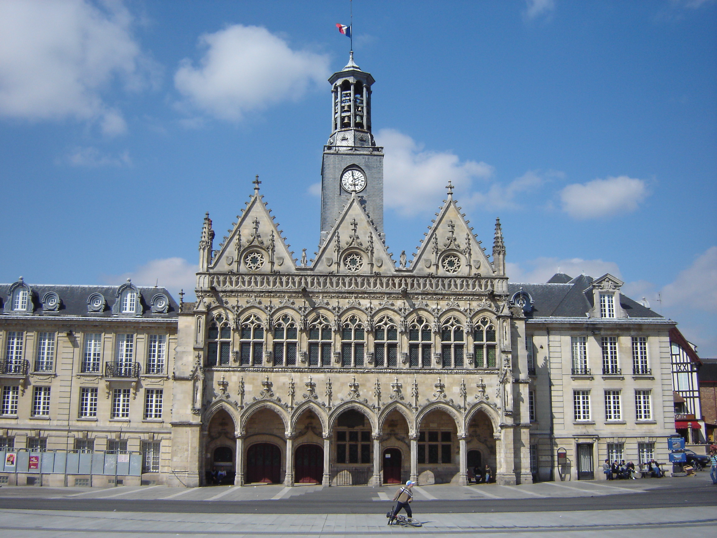
- Hôtel de ville (city hall), built between 1331 and 1509 in a gothic style. L'hôtel de ville of Saint-Quentin is famous for its peal of 37 bells. It was modified in the 19th century and heavily restored in 1926 in Art Déco style.[9]
- The municipal theatre Jean-Vilar, built in 1844.[10]
- The city has several beguinages, dating from the Middle-Age.
- The Fervaques palace: was built between 1897 and 1911, it is the place of High court.
- The Porte des Canonniers, a 17th century city gate
Museums
- Butterflies' Museum which has a collection of more than 600,000 insects, displaying 20,000 of them
- Antoine Lecuyer Museum which owns the largest collection of Maurice Quentin de La Tour's pastels
- Academic Society, archaeologic museum Société Académique de Saint-Quentin
Transport
The Gare de Saint-Quentin is the railway station, offering connections to Paris, Reims, Amiens, Lille and several regional destinations. The A26 motorway connects Saint-Quentin with Reims and Calais, the A29 with Amiens.
Personalities
- Alexis Yetna, basketball player
- Viviane Adjutor, basketball player
- Anthony Benezet, American Abolitionist
- Dudo of Saint-Quentin (born ca. 965), historian
- Charles de Bouelles (1479–1567), philosopher, mathematician and linguist
- Quentin-Claude Bendier (died 1677), scholar and bibliophile
- William Cliff, inventor of machine-woven tulle
- Marc Delmas (1885–1931), Expressionist composer and biographer
- Jeanne-Marie de Maille (1331-1414), saint
- Antoine Francisque (c.1570–1605), lutenist and composer
- Jules Gallay (1822–1897), lawyer and music historian
- Rudy Gobert (born 1992), professional basketball player for the Minnesota Timberwolves of the NBA; 3x Defensive Player of the Year
- Kafetien Gomis (born 1980), athlete
- Étienne Mendy (born 1969), footballer
- Jean Louis Marie Poiret (1755–1834), botanist and explorer
- François-Noël Babeuf (1760–1797), known as Gracchus Babeuf, political agitator and journalist of the revolutionary period
- Charles Rogier (1800–1885), Belgian statesman
- Félix Davin (1807–1836), French poet and journalist
- Jean Leune (1889 - 1944), war correspondent, writer, military officer, and member of the French Resistance.
- Andre Trocme pacifist Protestant church leader.
- Yves Velan (1925-2017), Swiss writer
- Jean-Marie Lefèvre (born 1953), modernist and minimalist poet
- Xavier Bertrand (born 1965), former Minister of Labour, Social Relations, Family and Solidarity in François Fillon's second government, conservative
- Édouard Lucien Briquet (1854-1905) (engineer, left Paris under siege, going to work on the construction of the Trans-Saharan Railroad, in the 1870s. He moved to Brazil in 1883, working on several railroads in the interior of the country.
Artists
- Mathieu (de) Bléville, born in Saint-Quentin at the beginning of the 16th century, painter on glass (vitraux).
- Pierre Berton (16th century), « Pierre de Saint-Quentin », stonecutter.
- Ulysse Butin (1838–1883), painter.
- John Cross, (1819-1861), English painter who studied at the Saint-Quentin School of Design
- Benoît Delépine (1958-), scriptwriter, actor.
- Michel Dorigny (1617–1665), painter and printmaker, professor at Painting Academy of Paris.
- Delphine Gleize (1973-), film director.
- Paul Guiramand, (1926–2007), painter and winner of the grand prix de Rome in 1953.
- Édouard Hippolyte Margottet (1848–1887), painter.
- Arthur Midy (1887–1944), painter.
- Amédée Ozenfant (1886–1966), leader of Purism, an avant-garde movement of the 1920s.
- Jean-Christophe Paré, (1957-) dancer and teacher.
- Julie-Marie Parmentier (1981-), actress.
- Maurice Pillard dit Verneuil, (born in 29 avril 1869 - died in 1942, Genève), well-known illustrator of Art nouveau.
- Maurice Quentin de La Tour (1704–1788), pastellist, he became famous by his portrait, portrait painter official of Louis XV, benefactor of the city (foundation of School of design Maurice Quentin de La Tour).
French sartorial heritage
The city was a pivotal centre of mulquinerie.
Twin towns - sister cities
Saint-Quentin is twinned with:[11]
 Kaiserslautern, Germany
 Rotherham, Yorkshire, England
 San Lorenzo de El Escorial, Spain
 Tongzhou (Beijing), China
See also
- Battle of St. Quentin (disambiguation)
- Communes of the Aisne department
- Augusta Viromanduorum
Gallery
 The Basilica
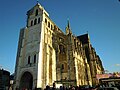 The Basilica with renovations to front entrance
 The Railway Station
 Félix Davin (1807-1836), French poet and journalist


References
- "Répertoire national des élus: les maires". data.gouv.fr, Plateforme ouverte des données publiques françaises (in French). 2 December 2020.
- "Populations légales 2019". The National Institute of Statistics and Economic Studies. 29 December 2021.
- "Données climatiques de la station de Saint-Quentin" (in French). Meteo France. Retrieved January 14, 2016.
- "Climat Picardie" (in French). Meteo France. Retrieved January 12, 2016.
- "Normes et records 1961-1990: Saint-Quentin - Roupy (02) - altitude 98m" (in French). Infoclimat. Retrieved January 14, 2016.
- Des villages de Cassini aux communes d'aujourd'hui: Commune data sheet Saint-Quentin, EHESS. (in French)
- Population en historique depuis 1968, INSEE
- Base Mérimée: L'ancienne collégiale royale, puis église paroissiale, actuellement basilique Saint-Quentin, Ministère français de la Culture. (in French)
- Base Mérimée: Hôtel de ville, Ministère français de la Culture. (in French)
- Base Mérimée: Théâtre municipal, Ministère français de la Culture. (in French)
- "Jumelages". saint-quentin.fr (in French). Saint-Quentin. Retrieved 2019-11-18.
External links
- Official website (in French and English)
- Official website of Saint-Quentin tourism office (in French and English)
- Historical footage of Saint-Quentin in World War I, europeanfilmgateway.eu
Authority control | |
|---|---|
| General | |
| National libraries | |
| Other | |
На других языках
[de] Saint-Quentin
Saint-Quentin (flämisch: Sint-Kwintens) ist eine nordfranzösische Gemeinde im Département Aisne in der Region Hauts-de-France. Sie ist der Hauptort des Arrondissements Saint-Quentin sowie Sitz des Kommunalverbandes Saint-Quentinois.- [en] Saint-Quentin, Aisne
[es] San Quintín (Aisne)
San Quintín (en francés Saint-Quentin) es una ciudad y comuna francesa, situada en el departamento de Aisne, de la región de Alta Francia.[fr] Saint-Quentin
Saint-Quentin (/sɛ̃.kɑ̃.tɛ̃/) est une commune française située dans le département de l'Aisne, en région Hauts-de-France. Comptant la plus importante population du département, dont elle est une sous-préfecture, Saint-Quentin est la neuvième commune la plus peuplée de la région. La ville picarde est située sur la Somme. Les habitants de Saint-Quentin sont les Saint-Quentinois.[ru] Сен-Кантен
Сен-Канте́н (фр. Saint-Quentin [sɛ̃.kɑ̃.tɛ̃], пикард. Saint-Quintin, Saint-Kintin) — город (коммуна) в регионе О-де-Франс, самый крупный в департаменте Эна. Расположен в 107 км к югу от Лилля и в 150 к северо-востоку от Парижа, на правом берегу Соммы у её соединения с каналом Сен-Кантен. В центре города расположена железнодорожная станция Сен-Кантен линии Крей-Жёмон.Другой контент может иметь иную лицензию. Перед использованием материалов сайта WikiSort.org внимательно изучите правила лицензирования конкретных элементов наполнения сайта.
WikiSort.org - проект по пересортировке и дополнению контента Википедии