world.wikisort.org - France
Reuilly-Sauvigny (French pronunciation: [ʁœji soviɲi]) is a commune in the Aisne department in Hauts-de-France in northern France.
This article may be expanded with text translated from the corresponding article in French. (December 2008) Click [show] for important translation instructions.
|
Reuilly-Sauvigny | |
|---|---|
Commune | |
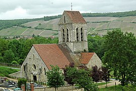
 The church of Reuilly-Sauvigny | |
 Coat of arms | |
Location of Reuilly-Sauvigny  | |
 Reuilly-Sauvigny  Reuilly-Sauvigny | |
| Coordinates: 49°03′32″N 3°33′30″E | |
| Country | France |
| Region | Hauts-de-France |
| Department | Aisne |
| Arrondissement | Château-Thierry |
| Canton | Essômes-sur-Marne |
| Intercommunality | Région de Château-Thierry |
| Government | |
| • Mayor (2020–2026) | Daniel Saroul[1] |
| Area 1 | 6.54 km2 (2.53 sq mi) |
| Population | 192 |
| • Density | 29/km2 (76/sq mi) |
| Time zone | UTC+01:00 (CET) |
| • Summer (DST) | UTC+02:00 (CEST) |
| INSEE/Postal code | 02645 /02850 |
| Elevation | 62–241 m (203–791 ft) (avg. 67 m or 220 ft) |
| 1 French Land Register data, which excludes lakes, ponds, glaciers > 1 km2 (0.386 sq mi or 247 acres) and river estuaries. | |
Geography
The village is located in Condé-en-Brie, in the south of the Aisne department, bordering on the Marne department. About 10 kilometres to the east of the commune is Château-Thierry, which is located on a hillside in Marne.
History
Two surrounding fords meant it was easiest to cross la Marne at the top of the commune, making it a strategic point during the two World wars, during which Reuilly was very heavily damaged.
Heraldry
The Reuilly-Sauvigny coat of arms is emblazoned with: Green with a golden sword, three lioncubs stitched on a silver waving fabric
Sights
- Église Saint Blaise, dating back to the 13th century
Population
| Year | Pop. | ±% p.a. |
|---|---|---|
| 1968 | 155 | — |
| 1975 | 153 | −0.19% |
| 1982 | 163 | +0.91% |
| 1990 | 189 | +1.87% |
| 1999 | 213 | +1.34% |
| 2007 | 234 | +1.18% |
| 2012 | 223 | −0.96% |
| 2017 | 201 | −2.06% |
| Source: INSEE[3] | ||
See also
References
- "Répertoire national des élus: les maires". data.gouv.fr, Plateforme ouverte des données publiques françaises (in French). 2 December 2020.
- "Populations légales 2019". The National Institute of Statistics and Economic Studies. 29 December 2021.
- Population en historique depuis 1968, INSEE
Wikimedia Commons has media related to Reuilly-Sauvigny.
На других языках
[de] Reuilly-Sauvigny
Reuilly-Sauvigny ist eine französische Gemeinde mit 192 Einwohnern (Stand: 1. Januar 2019) im Département Aisne in der Region Hauts-de-France (frühere Region: Picardie). Die Gemeinde gehört zum Arrondissement Château-Thierry und ist Teil des Kantons Essômes-sur-Marne (früher: Condé-en-Brie).- [en] Reuilly-Sauvigny
[ru] Рёйи-Совиньи
Рёйи́-Совиньи́ (фр. Reuilly-Sauvigny) — коммуна во Франции, находится в регионе Пикардия. Департамент коммуны — Эна. Входит в состав кантона Эссом-сюр-Марн. Округ коммуны — Шато-Тьерри.Текст в блоке "Читать" взят с сайта "Википедия" и доступен по лицензии Creative Commons Attribution-ShareAlike; в отдельных случаях могут действовать дополнительные условия.
Другой контент может иметь иную лицензию. Перед использованием материалов сайта WikiSort.org внимательно изучите правила лицензирования конкретных элементов наполнения сайта.
Другой контент может иметь иную лицензию. Перед использованием материалов сайта WikiSort.org внимательно изучите правила лицензирования конкретных элементов наполнения сайта.
2019-2025
WikiSort.org - проект по пересортировке и дополнению контента Википедии
WikiSort.org - проект по пересортировке и дополнению контента Википедии