world.wikisort.org - France
Landrethun-le-Nord (French pronunciation: [lɑ̃dʁətœ̃ lə nɔʁ]; West Flemish: Landerten) is a commune in the Pas-de-Calais department in the Hauts-de-France region of France.[2]
Landrethun-le-Nord
Landerten | |
|---|---|
Commune | |
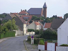
 A general view of Landrethun-le-Nord | |
 Coat of arms | |
Location of Landrethun-le-Nord  | |
 Landrethun-le-Nord  Landrethun-le-Nord | |
| Coordinates: 50°50′53″N 1°47′05″E | |
| Country | France |
| Region | Hauts-de-France |
| Department | Pas-de-Calais |
| Arrondissement | Boulogne-sur-Mer |
| Canton | Desvres |
| Intercommunality | CC Terre des Deux Caps |
| Government | |
| • Mayor (2020–2026) | Michel Delmaire |
| Area 1 | 7.7 km2 (3.0 sq mi) |
| Population | 1,268 |
| • Density | 160/km2 (430/sq mi) |
| Time zone | UTC+01:00 (CET) |
| • Summer (DST) | UTC+02:00 (CEST) |
| INSEE/Postal code | 62487 /62250 |
| Elevation | 57–133 m (187–436 ft) (avg. 116 m or 381 ft) |
| 1 French Land Register data, which excludes lakes, ponds, glaciers > 1 km2 (0.386 sq mi or 247 acres) and river estuaries. | |
Geography
A farming village situated some 13 miles (21 km) northeast of Boulogne, at the junction of the D243 and D231 roads.
History
The area was severely bombed during 1944 as the Germans chose this commune to host the V-3 cannon launch site during World War II.
Population
| Year | Pop. | ±% p.a. |
|---|---|---|
| 1968 | 625 | — |
| 1975 | 744 | +2.52% |
| 1982 | 707 | −0.73% |
| 1990 | 853 | +2.37% |
| 1999 | 906 | +0.67% |
| 2007 | 1,118 | +2.66% |
| 2012 | 1,237 | +2.04% |
| 2017 | 1,299 | +0.98% |
| Source: INSEE[3] | ||
Places of interest
- The church of St.Martin, dating from the twentieth century.
- The Second World War Fortress of Mimoyecques.
See also
References
- "Populations légales 2019". The National Institute of Statistics and Economic Studies. 29 December 2021.
- INSEE commune file
- Population en historique depuis 1968, INSEE
Wikimedia Commons has media related to Landrethun-le-Nord.
Текст в блоке "Читать" взят с сайта "Википедия" и доступен по лицензии Creative Commons Attribution-ShareAlike; в отдельных случаях могут действовать дополнительные условия.
Другой контент может иметь иную лицензию. Перед использованием материалов сайта WikiSort.org внимательно изучите правила лицензирования конкретных элементов наполнения сайта.
Другой контент может иметь иную лицензию. Перед использованием материалов сайта WikiSort.org внимательно изучите правила лицензирования конкретных элементов наполнения сайта.
2019-2025
WikiSort.org - проект по пересортировке и дополнению контента Википедии
WikiSort.org - проект по пересортировке и дополнению контента Википедии