world.wikisort.org - France
Longvilliers (French pronunciation: [lɔ̃vilje] (![]() listen); until 1997 Longvillers) is a commune in the Pas-de-Calais department in the Hauts-de-France region of France.[2]
listen); until 1997 Longvillers) is a commune in the Pas-de-Calais department in the Hauts-de-France region of France.[2]
Longvilliers | |
|---|---|
Commune | |
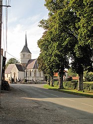
 The church of Longvilliers | |
 Coat of arms | |
Location of Longvilliers  | |
 Longvilliers  Longvilliers | |
| Coordinates: 50°32′40″N 1°43′42″E | |
| Country | France |
| Region | Hauts-de-France |
| Department | Pas-de-Calais |
| Arrondissement | Montreuil |
| Canton | Étaples |
| Intercommunality | CA Deux Baies en Montreuillois |
| Government | |
| • Mayor (2020–2026) | Philippe Petit |
| Area 1 | 10.99 km2 (4.24 sq mi) |
| Population | 253 |
| • Density | 23/km2 (60/sq mi) |
| Time zone | UTC+01:00 (CET) |
| • Summer (DST) | UTC+02:00 (CEST) |
| INSEE/Postal code | 62527 /62630 |
| Elevation | 19–120 m (62–394 ft) (avg. 40 m or 130 ft) |
| 1 French Land Register data, which excludes lakes, ponds, glaciers > 1 km2 (0.386 sq mi or 247 acres) and river estuaries. | |
Geography
Longvilliers is situated 5 miles (9 km) north of Montreuil-sur-Mer on the D146 road and in the Dordonne river valley. With a population of little over 250, it retains the character and atmosphere of the French countryside.[original research?] There are no shops, but it is near enough to Frencq (5 km), Montreuil-sur-Mer (9 km) and Étaples (10 km). The area around offers views and walks in the countryside.[citation needed]
Population
| Year | Pop. | ±% p.a. |
|---|---|---|
| 1968 | 297 | — |
| 1975 | 263 | −1.72% |
| 1982 | 243 | −1.12% |
| 1990 | 244 | +0.05% |
| 1999 | 250 | +0.27% |
| 2007 | 229 | −1.09% |
| 2012 | 263 | +2.81% |
| 2017 | 247 | −1.25% |
| Source: INSEE[3] | ||
Places of interest
- The fifteenth-century church.
- Ruins of the 16th-century château.
- Vestiges of a cistercian abbey from the twelfth century.
- Remains of the manor of Tatéville, of 1586.
See also
References
- "Populations légales 2019". The National Institute of Statistics and Economic Studies. 29 December 2021.
- INSEE commune file
- Population en historique depuis 1968, INSEE
Wikimedia Commons has media related to Longvilliers (Pas-de-Calais).
На других языках
[de] Longvilliers (Pas-de-Calais)
Longvilliers ist eine französische Gemeinde mit 253 Einwohnern (Stand 1. Januar 2019) im Département Pas-de-Calais in der Region Hauts-de-France (vor 2016 Nord-Pas-de-Calais). Sie gehört zum Arrondissement Montreuil und zum Kanton Étaples. Die Einwohner werden Longvillois genannt.- [en] Longvilliers, Pas-de-Calais
Текст в блоке "Читать" взят с сайта "Википедия" и доступен по лицензии Creative Commons Attribution-ShareAlike; в отдельных случаях могут действовать дополнительные условия.
Другой контент может иметь иную лицензию. Перед использованием материалов сайта WikiSort.org внимательно изучите правила лицензирования конкретных элементов наполнения сайта.
Другой контент может иметь иную лицензию. Перед использованием материалов сайта WikiSort.org внимательно изучите правила лицензирования конкретных элементов наполнения сайта.
2019-2025
WikiSort.org - проект по пересортировке и дополнению контента Википедии
WikiSort.org - проект по пересортировке и дополнению контента Википедии