world.wikisort.org - France
Hermaville (French pronunciation: [ɛʁmavil]) is a commune in the Pas-de-Calais department in the Hauts-de-France region of France.[3]
Hermaville | |
|---|---|
Commune | |
 An aerial view of Hermaville | |
 Coat of arms | |
Location of Hermaville  | |
 Hermaville  Hermaville | |
| Coordinates: 50°19′24″N 2°35′14″E | |
| Country | France |
| Region | Hauts-de-France |
| Department | Pas-de-Calais |
| Arrondissement | Arras |
| Canton | Avesnes-le-Comte |
| Intercommunality | CC Campagnes de l'Artois |
| Government | |
| • Mayor (2020–2026) | Michel Accart[1] |
| Area 1 | 6.32 km2 (2.44 sq mi) |
| Population | 533 |
| • Density | 84/km2 (220/sq mi) |
| Time zone | UTC+01:00 (CET) |
| • Summer (DST) | UTC+02:00 (CEST) |
| INSEE/Postal code | 62438 /62690 |
| Elevation | 85–142 m (279–466 ft) (avg. 94 m or 308 ft) |
| 1 French Land Register data, which excludes lakes, ponds, glaciers > 1 km2 (0.386 sq mi or 247 acres) and river estuaries. | |
Geography
A farming village situated 8 miles (13 km) west of Arras, at the junction of the D54 and the D74 roads.
Population
| Year | 1962 | 1968 | 1975 | 1982 | 1990 | 1999 | 2006 |
|---|---|---|---|---|---|---|---|
| Population | 315 | 329 | 313 | 402 | 456 | 455 | 536 |
| From the year 1962 on: No double counting—residents of multiple communes (e.g. students and military personnel) are counted only once. | |||||||
Places of interest
- The church of St. Georges, dating from the seventeenth century.
- The chateau, dating from the eighteenth century.
- Traces of an old castle, destroyed in 1640 by the French.
See also
References
- "Répertoire national des élus: les maires". data.gouv.fr, Plateforme ouverte des données publiques françaises (in French). 2 December 2020.
- "Populations légales 2019". The National Institute of Statistics and Economic Studies. 29 December 2021.
- INSEE commune file
External links
| Wikimedia Commons has media related to Hermaville. |
 Saint Georges church in winter
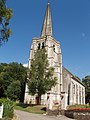 The church in summer
 A niche over the church porch
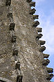 Unusual features on the spire
 The Salignac-Fénelon family crypt
 The farm of Saint Georges
 A millstone
 The village hall


This Arras arrondissement, Pas-de-Calais geographical article is a stub. You can help Wikipedia by expanding it. |
Текст в блоке "Читать" взят с сайта "Википедия" и доступен по лицензии Creative Commons Attribution-ShareAlike; в отдельных случаях могут действовать дополнительные условия.
Другой контент может иметь иную лицензию. Перед использованием материалов сайта WikiSort.org внимательно изучите правила лицензирования конкретных элементов наполнения сайта.
Другой контент может иметь иную лицензию. Перед использованием материалов сайта WikiSort.org внимательно изучите правила лицензирования конкретных элементов наполнения сайта.
2019-2026
WikiSort.org - проект по пересортировке и дополнению контента Википедии
WikiSort.org - проект по пересортировке и дополнению контента Википедии