world.wikisort.org - France
Frévent (French pronunciation: [fʁevɑ̃]) is a commune in the Pas-de-Calais department in the Hauts-de-France region of France.[3]
Frévent | |
|---|---|
Commune | |
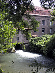
 Blondel watermill, housing the Wintenberger Museum | |
 Coat of arms | |
Location of Frévent  | |
 Frévent  Frévent | |
| Coordinates: 50°16′38″N 2°17′20″E | |
| Country | France |
| Region | Hauts-de-France |
| Department | Pas-de-Calais |
| Arrondissement | Arras |
| Canton | Saint-Pol-sur-Ternoise |
| Intercommunality | CC Ternois |
| Government | |
| • Mayor (2020–2026) | Jean-François Théret[1] |
| Area 1 | 15.23 km2 (5.88 sq mi) |
| Population | 3,423 |
| • Density | 220/km2 (580/sq mi) |
| Demonym(s) | Fréventins |
| Time zone | UTC+01:00 (CET) |
| • Summer (DST) | UTC+02:00 (CEST) |
| INSEE/Postal code | 62361 /62270 |
| Elevation | 62–145 m (203–476 ft) (avg. 79 m or 259 ft) |
| 1 French Land Register data, which excludes lakes, ponds, glaciers > 1 km2 (0.386 sq mi or 247 acres) and river estuaries. | |
Geography
A farming town situated in the valley of the Canche river, 20 miles (32 km) west of Arras, at the junction of the D946, the D939 and the D941 roads.
History
The year 1137 saw the establishment of a Cistercian abbey by the Count de Saint-Pol at the hamlet of Cercamp. The town was invaded in 1537 by the French, and the castle was burned down in 1543 by the Duke of Vendôme. Frévent was partially destroyed by Allied bombing in 1944 during the Second World War.
Population
The inhabitants are called Fréventins.
| Year | Pop. | ±% p.a. |
|---|---|---|
| 1968 | 4,531 | — |
| 1975 | 4,322 | −0.67% |
| 1982 | 4,217 | −0.35% |
| 1990 | 4,121 | −0.29% |
| 1999 | 3,952 | −0.46% |
| 2007 | 3,745 | −0.67% |
| 2012 | 3,702 | −0.23% |
| 2017 | 3,570 | −0.72% |
| Source: INSEE[4] | ||
Places of interest
- The church of St. Hilaire, dating from the sixteenth century.
- The church of St. Vaast, dating from the twentieth century.
- The chateau at Cercamp, dating from the nineteenth century.
- The abbey and park at Cercamp.
- A former flour mill.
- The Louis Ducatel Museum, housing works of the painter Louis Ducatel, local archaeology, costumes and sculptures.
- The Wintenberger Museum, with a history of flour mills and a collection of tools and farm equipment.
See also
References
- "Répertoire national des élus: les maires". data.gouv.fr, Plateforme ouverte des données publiques françaises (in French). 2 December 2020.
- "Populations légales 2019". The National Institute of Statistics and Economic Studies. 29 December 2021.
- INSEE commune file
- Population en historique depuis 1968, INSEE
Wikimedia Commons has media related to Frévent.
На других языках
- [en] Frévent
[ru] Фреван
Фреван (фр. Frévent) — коммуна во Франции, регион О-де-Франс, департамент Па-де-Кале, округ Аррас, кантон Сен-Поль-сюр-Тернуаз. Расположена в 32 км к западу от Арраса, в 15 км от национальной автомагистрали N25, на обоих берегах реки Канш.Текст в блоке "Читать" взят с сайта "Википедия" и доступен по лицензии Creative Commons Attribution-ShareAlike; в отдельных случаях могут действовать дополнительные условия.
Другой контент может иметь иную лицензию. Перед использованием материалов сайта WikiSort.org внимательно изучите правила лицензирования конкретных элементов наполнения сайта.
Другой контент может иметь иную лицензию. Перед использованием материалов сайта WikiSort.org внимательно изучите правила лицензирования конкретных элементов наполнения сайта.
2019-2025
WikiSort.org - проект по пересортировке и дополнению контента Википедии
WikiSort.org - проект по пересортировке и дополнению контента Википедии