world.wikisort.org - USA
Fairfield is a city in and the county seat of Solano County, California, in the North Bay sub-region of the San Francisco Bay Area. It is generally considered the midpoint between the cities of San Francisco and Sacramento, approximately 40 miles (64 km) from the city center of each city, approximately 40 miles (64 km) from the city center of Oakland, less than 19 miles (31 km) from Napa Valley, 16 miles (26 km) from the Carquinez Bridge, and 14 miles (23 km) from the Benicia Bridge. Fairfield was founded in 1856 by clippership captain Robert H. Waterman, and named after his former hometown of Fairfield, Connecticut.
This article's lead section may be too short to adequately summarize the key points. (September 2021) |
Fairfield, California | |
|---|---|
Sign in Downtown Fairfield | |
 Seal | |
 Location of Fairfield in Solano County, California. | |
 Fairfield Location in California  Fairfield Location in the United States | |
| Coordinates: 38°15′28″N 122°3′15″W | |
| Country | United States |
| State | California |
| County | Solano |
| Incorporated | December 12, 1903[1] |
| Government | |
| • Type | Council-manager[2] |
| • Mayor | Harry T. Price[3] |
| • State senator | Bill Dodd (D)[4] |
| • Assemblymember | Lori Wilson (D)[4] |
| • U. S. rep. | John Garamendi (D)[5] |
| Area | |
| • Total | 41.39 sq mi (107.21 km2) |
| • Land | 41.14 sq mi (106.55 km2) |
| • Water | 0.26 sq mi (0.66 km2) 6.95% |
| Elevation | 13 ft (4 m) |
| Population (2020)[8] | |
| • Total | 119,881 |
| • Rank | 2nd in Solano County 53rd in California |
| • Density | 2,900/sq mi (1,100/km2) |
| Time zone | UTC−8 (Pacific) |
| • Summer (DST) | UTC−7 (PDT) |
| ZIP codes[9] | 94533–94535 |
| Area code | 707 |
| FIPS code | 06-23182 |
| GNIS feature IDs | 1656005, 2410474 |
| Website | www |
It is the home of Travis Air Force Base and the headquarters of Jelly Belly. With a population of 119,881 at the 2020 census, it is slightly smaller in population than Vallejo. Other nearby cities include Suisun City, Vacaville, Rio Vista, Benicia, and Napa.
Geography
According to the United States Census Bureau, the city has a total area of 37.6 square miles (97 km2), of which, 34.4 square miles (89 km2) of it is land and 3.2 square miles (8.3 km2) of it is water. The total area is 5.65% water.
The city is located within the California Coastal Ranges. The city is centered directly north of the Suisun Bay and northeast of the San Pablo Bay. Much of the Suisun Bay contains the Suisun Marsh, the largest saltwater marsh on the west coast of the United States.
The city includes one hospital, NorthBay Medical Center, a 154-bed advanced medical facility that also features a level II Trauma Center.
History
According to the City of Fairfield website,[10] Native Americans, such as those from the Ion culture, settled in the Rockville and Green Valley areas. Artifacts that have been found from some of the earliest human inhabitants of the Fairfield area are dated to be around five to six thousand years old, making them some of the oldest Native American settlements in Northern California.
The first European contact came in 1810 when the Spanish army was ordered to attack the Suisun Indians. In 1835 the Mexican General Vallejo was so magnanimous in victory over the Indian Chief Sem Yeto that the chief later became his ally in conflicts against other tribes. In 1837 the Indian Chief Solano received the Rancho Suisun Mexican land grant. This grant eventually came into the hands of a clipper ship captain from Fairfield, Connecticut named Robert H. Waterman. He not only parceled out the town in 1856, but also, in a commercially shrewd move, entered Fairfield in the race for Solano County seat in 1858, and won it from Benicia. As an inducement he granted 16 acres (6.5 ha) of land for the construction of county buildings. In 1903 Fairfield was incorporated as a city.
In August 2020, parts of Fairfield were evacuated due to the Hennessey Fire, which resulted in the burning of over 315,000 acres (127,476 ha) in five counties, including in nearby Vacaville.[11]
Demographics
| Historical population | |||
|---|---|---|---|
| Census | Pop. | %± | |
| 1870 | 329 | — | |
| 1880 | 424 | 28.9% | |
| 1910 | 834 | — | |
| 1920 | 1,008 | 20.9% | |
| 1930 | 1,131 | 12.2% | |
| 1940 | 1,312 | 16.0% | |
| 1950 | 3,118 | 137.7% | |
| 1960 | 14,968 | 380.1% | |
| 1970 | 44,146 | 194.9% | |
| 1980 | 58,099 | 31.6% | |
| 1990 | 77,211 | 32.9% | |
| 2000 | 96,178 | 24.6% | |
| 2010 | 105,321 | 9.5% | |
| 2020 | 119,881 | 13.8% | |
| U.S. Decennial Census[12] | |||
2010
The 2010 United States Census[13] reported that Fairfield had a population of 105,322. The population density was 2,798.5 inhabitants per square mile (1,080.5/km2). The racial makeup of Fairfield was 48,407 (46.0%) White, 16,586 (15.7%) African American, 869 (0.8%) Native American, 15,700 (14.9%) Asian (9.1% Filipino, 1.8% Indian, 1.0% Chinese, 0.6% Vietnamese, 0.6% Japanese, 0.4% Korean, 0.3% Laotian, 0.2% Thai, 0.1% Pakistani), 1,149 (1.1%) Pacific Islander, 13,301 (12.6%) from other races, and 9,309 (8.8%) from two or more races. Hispanic or Latino of any race were 28,789 persons (27.3%); 21.2% of Fairfield was Mexican, 1.1% Puerto Rican, 1.0% Salvadoran, 0.5% Nicaraguan, 0.3% Guatemalan, 0.2% Cuban, and 0.2% Peruvian.
The Census reported that 102,832 people (97.6% of the population) lived in households, 1,221 (1.2%) lived in non-institutionalized group quarters, and 1,268 (1.2%) were institutionalized.
There were 34,484 households, out of which 14,725 (42.7%) had children under the age of 18 living in them, 18,461 (53.5%) were opposite-sex married couples living together, 5,203 (15.1%) had a female householder with no husband present, 2,179 (6.3%) had a male householder with no wife present. There were 2,052 (6.0%) unmarried opposite-sex partnerships, and 237 (0.7%) same-sex married couples or partnerships. 6,802 households (19.7%) were made up of individuals, and 2,500 (7.2%) had someone living alone who was 65 years of age or older. The average household size was 2.98. There were 25,843 families (74.9% of all households); the average family size was 3.42.
The population was spread out, with 28,499 people (27.1%) under the age of 18, 11,246 people (10.7%) aged 18 to 24, 28,917 people (27.5%) aged 25 to 44, 25,884 people (24.6%) aged 45 to 64, and 10,775 people (10.2%) who were 65 years of age or older. The median age was 33.7 years. For every 100 females, there were 97.0 males. For every 100 females age 18 and over, there were 94.6 males.
There were 37,184 housing units at an average density of 988.0 per square mile (381.5/km2), of which 20,835 (60.4%) were owner-occupied, and 13,649 (39.6%) were occupied by renters. The homeowner vacancy rate was 2.5%; the rental vacancy rate was 7.1%. 61,652 people (58.5% of the population) lived in owner-occupied housing units and 41,180 people (39.1%) lived in rental housing units.
2000
As of the census[14] of 2000, there were 96,178 people, 30,870 households, and 24,016 families residing in the city. The population density was 986.3/km2 (2,554.2/mi2). There were 31,792 housing units at an average density of 326.0/km2 (844.3/mi2). The racial makeup of the city was 56.21% White, 15.02% Black or African American, 0.77% Native American, 10.89% Asian, 0.93% Pacific Islander, 8.77% from other races, and 7.41% from two or more races. 18.77% of the population were Hispanic or Latino of any race.
There were 30,870 households, out of which 43.1% had children under the age of 18 living with them, 58.4% were married couples living together, 14.2% had a female householder with no husband present, and 22.2% were non-families. 17.0% of all households were made up of individuals, and 5.5% had someone living alone who was 65 years of age or older. The average household size was 2.98 and the average family size was 3.33.
In the city, the population was spread out, with 29.8% under the age of 18, 11.1% from 18 to 24, 31.3% from 25 to 44, 18.8% from 45 to 64, and 9.0% who were 65 years of age or older. The median age was 31 years. For every 100 females, there were 99.1 males. For every 100 females age 18 and over, there were 97.4 males.
The median income for a household in the city was $51,151, and the median income for a family was $55,503. Males had a median income of $38,544 versus $30,616 for females. The per capita income for the city was $20,617. 9.3% of the population and 7.1% of families were below the poverty line. Out of the total population, 12.1% of those under the age of 18 and 5.2% of those 65 and older were living below the poverty line.
Climate
Fairfield has a hot-summer Mediterranean climate (Köppen Csa). Summers have hot afternoons with cool nights with a lengthy dry period, whereas winters see frequent rainfall with mild to cool temperatures.
| Climate data for Fairfield, California, 1991–2020 normals, extremes 1950–present | |||||||||||||
|---|---|---|---|---|---|---|---|---|---|---|---|---|---|
| Month | Jan | Feb | Mar | Apr | May | Jun | Jul | Aug | Sep | Oct | Nov | Dec | Year |
| Record high °F (°C) | 76 (24) |
80 (27) |
89 (32) |
98 (37) |
111 (44) |
111 (44) |
114 (46) |
111 (44) |
117 (47) |
104 (40) |
87 (31) |
78 (26) |
117 (47) |
| Mean maximum °F (°C) | 66.8 (19.3) |
72.8 (22.7) |
78.9 (26.1) |
87.2 (30.7) |
93.6 (34.2) |
102.8 (39.3) |
104.1 (40.1) |
103.7 (39.8) |
100.8 (38.2) |
92.5 (33.6) |
78.2 (25.7) |
67.3 (19.6) |
106.7 (41.5) |
| Average high °F (°C) | 56.6 (13.7) |
61.6 (16.4) |
66.4 (19.1) |
71.3 (21.8) |
77.8 (25.4) |
85.4 (29.7) |
89.6 (32.0) |
89.2 (31.8) |
86.9 (30.5) |
78.2 (25.7) |
65.6 (18.7) |
56.7 (13.7) |
73.8 (23.2) |
| Daily mean °F (°C) | 48.5 (9.2) |
52.2 (11.2) |
55.9 (13.3) |
59.6 (15.3) |
65.0 (18.3) |
70.8 (21.6) |
73.8 (23.2) |
73.6 (23.1) |
71.7 (22.1) |
65.2 (18.4) |
55.4 (13.0) |
48.4 (9.1) |
61.7 (16.5) |
| Average low °F (°C) | 40.4 (4.7) |
42.9 (6.1) |
45.4 (7.4) |
47.9 (8.8) |
52.2 (11.2) |
56.1 (13.4) |
57.9 (14.4) |
58.0 (14.4) |
56.6 (13.7) |
52.3 (11.3) |
45.2 (7.3) |
40.1 (4.5) |
49.6 (9.8) |
| Mean minimum °F (°C) | 30.8 (−0.7) |
34.4 (1.3) |
36.8 (2.7) |
39.0 (3.9) |
44.7 (7.1) |
48.9 (9.4) |
52.3 (11.3) |
52.8 (11.6) |
49.3 (9.6) |
44.4 (6.9) |
35.8 (2.1) |
29.9 (−1.2) |
28.2 (−2.1) |
| Record low °F (°C) | 18 (−8) |
24 (−4) |
29 (−2) |
29 (−2) |
35 (2) |
39 (4) |
40 (4) |
40 (4) |
39 (4) |
32 (0) |
21 (−6) |
15 (−9) |
15 (−9) |
| Average precipitation inches (mm) | 4.68 (119) |
4.97 (126) |
3.31 (84) |
1.47 (37) |
0.74 (19) |
0.19 (4.8) |
0.00 (0.00) |
0.03 (0.76) |
0.08 (2.0) |
1.11 (28) |
2.55 (65) |
5.40 (137) |
24.53 (623) |
| Average precipitation days (≥ 0.01 in) | 10.4 | 10.0 | 9.4 | 5.1 | 3.2 | 0.8 | 0.0 | 0.2 | 0.6 | 2.7 | 6.5 | 10.1 | 59 |
| Source: NOAA[15](September record high)[16] | |||||||||||||
Industry and major employers
Fairfield has a diversified economy, with government, manufacturing, health care, retail, professional and commercial construction sectors.[17] Anheuser-Busch operates a large regional Budweiser brewery, Clorox produces bleach products, and the Jelly Belly Candy Company confects its specialty jelly beans in Fairfield.[17] Partnership HealthPlan of California, an insurer, is based in Fairfield.
Top employers
According to the city's 2021 Annual Comprehensive Financial Report,[18] the top employers in the city are:
| # | Employer | # of Employees |
|---|---|---|
| 1 | Travis Air Force Base | 12,864 |
| 2 | County of Solano | 3,133 |
| 3 | NorthBay Medical Center | 2,824 |
| 4 | Fairfield-Suisun Unified School District | 2,235 |
| 5 | City of Fairfield | 602 |
| 6 | Jelly Belly | 426 |
| 7 | Paradise Valley Estates | 401 |
| 8 | FedEx Ground | 396 |
| 9 | Walmart | 369 |
| 10 | Partnership Health Plan | 350 |
Government and politics
There are five city councilmembers, which include the vice-Mayor, and Mayor. Councilmembers are elected at large for four-year, staggered terms. Elections are held in November of even-numbered years. Beginning in November 2020, city council elections in Fairfield will be conducted by district, with six district seats and an at-large mayoral seat for a total of seven council seats.[19]
Schools


- Area high schools:
- Angelo Rodriguez High School (Early College program)
- Armijo High School (International Baccalaureate program)
- Fairfield High School
- Sem Yeto High School (at Fairfield High School)
- Sem Yeto Satellite (at Armijo High School)
- Vanden High School
- Area middle schools:
- B. Gale Wilson Middle School
- Crystal Middle School
- Grange Middle School
- Golden West Middle School
- Green Valley Middle School
Area alternative schools and other programs:
- Fairfield-Suisun Adult School (Bransford location)
- H. Glenn Richardson Education Complex (DELTA and SIGMA Programs operated by SCOE)
- Independent Study Program (located at Sullivan Interagency Youth Services Center)
- Mary Bird Early Education Center (opening 2016–2017 school year)
- Matt Garcia Career & College Academy
- Public Safety Academy (Amy Blanc location; Grades 5-12)
- State Preschool Programs (Anna Kyle, Bransford, Fairview locations)
- Sullivan Interagency Youth Services Center (joint effort by FSUSD and the City of Fairfield/Fairfield Police Department)
- Travis Community Day School
- Travis Education Center
Area elementary schools:
- Anna Kyle Elementary School
- Center Elementary School
- Cleo Gordon Elementary School
- Cordelia Hills Elementary School
- David Weir K-8 Preparatory Academy
- Dover Academy for International Studies (K-8) (opening 2016–2017 school year)
- Sheldon Academy of Innovative Learning (K-8) (1:1 Technology focus)
- Fairview Elementary School
- Holy Spirit School (Catholic Private School K-8)
- K. I. Jones Elementary School (GATE Magnet Site)
- Laurel Creek Elementary School
- Nelda Mundy Elementary School
- Oakbrook Academy of the Arts (Visual & Performing Arts focus)
- Rolling Hills Elementary School
- Scandia Elementary School
- Suisun Valley K-8 School
- Tolenas Elementary School
- Travis Elementary School
Vanden High School, Golden West Middle School, Travis Education Center, Travis Community Day School, Center Elementary School, Scandia Elementary School, and Travis Elementary School are part of the Travis Unified School District (TUSD), and serve Travis Air Force Base (TAFB) as well as parts of Fairfield and Vacaville. Golden Hills Community School is part of the Solano County Office of Education (SCOE). All others are part of the Fairfield-Suisun Unified School District (FSUSD).
Universities and colleges nearby: the California Maritime Academy (CSU), UC Davis, UC Berkeley, Sacramento State, CSU East Bay, Sonoma State, St. Mary's College, University of Phoenix and Brandman University. The main campus of Solano Community College is located in Fairfield—as well as satellite campuses of University of Phoenix, Brandman University, InterCoast Colleges, and Embry Riddle Aeronautical University (at Travis AFB).
Recreation

Downtown Fairfield offers shopping, community festivals and entertainment.
- Parks
- Rockville Hills Regional Park
- The Park is located on Rockville Road approximately 3/4 of a mile from the corner of Suisun Valley and Rockville Roads. Allows bicycling, hiking, and provides walking trails.
- Fairfield Linear Park
- The Linear Park stretches through the city along a former railroad right-of-way. Picnic tables and play equipment can be found along the route. Runners, walkers, bicyclists, and families enjoy this park.
- Alan Witt Park
- Contains a brand new Aquatics Complex, the Fairfield Sports Center, and Fairfield-Suisun Rotary Skate Park. The new Aquatics Complex includes water slides, toddler play area, youth play pool, lap swimming, indoor activity pool, and a "lazy river" current for water walking or floating. The park also offers tennis courts, a recreation building, picnic area, ball fields, basketball courts, volleyball courts, a skate park, and horse shoe pits. Restroom facilities are available.
- Dover Park
- Sunrise Park
- Ridgeview Park
- Laurel Creek Park
- Contains softball fields, Little League baseball fields, a soccer field, a large picnic area with built in grills, a park for small children and a park for grown children, and is next to Laurel Creek Elementary School, which has outdoor basketball courts.
- Wood Creek Park
Fairfield is home to three golf courses, two public and one private (located in unincorporated area East of Fairfield, North of TAFB for use by military personnel). Paradise Valley and Rancho Solano Golf Courses, both public, are rated in the Zagat Survey of "America's Best Golf Courses," rated 3+1⁄2 stars by Golf Digest Magazine in 2010 and voted #1 and #2 golf courses in Solano County for consecutive years.
Transportation
Interstate 80 passes through Fairfield, connecting San Francisco to the southwest and Sacramento to the northeast. Interstate 680 begins its journey south through the eastern cities of the Bay Area to San Jose. State Route 12 connects Fairfield with Napa to the west, and Rio Vista to the east.
The Fairfield-Vacaville railroad station on Peabody Rd serves the communities of Fairfield/Suisun and Vacaville. The station opened in November 2017.[20] The station is served by Capitol Corridor trains operated by Amtrak California.[21] Additionally, the Suisun-Fairfield station in Suisun City serves the central Solano area. Greyhound utilizes this station for service to the Fairfield-Suisun area as well.
The Fairfield Transportation Center is the main hub for commuters via bus as well as vanpools and park-and-ride to the Sacramento area and the San Francisco Bay Area. There is connecting bus service to Sacramento and to BART stations in El Cerrito and Concord/Walnut Creek, as well as intercity to Vacaville, Vallejo, Davis, Napa, and Rio Vista.
Sister city relations
 - Nirasaki, Yamanashi, Japan[22]
Notable people
- Sasha Banks, professional wrestler for WWE
- Brad Bergesen, starting pitcher for the MLB Baltimore Orioles[23]
- Desmond Bishop, Super Bowl Champion former starting middle linebacker for the NFL Green Bay Packers, Graduated from Fairfield High School class of 2002
- Deone Bucannon, starting safety for the NFL Arizona Cardinals, Graduated from Vanden High School class of 2010
- Cat Cora starred in the television hit series Iron Chef America
- Chris Daly, former San Francisco supervisor
- Jacob Duran, professional Kickboxing, UFC and boxing cutman/Actor appeared in Rocky Balboa & Creed 1,2
- Huck Flener, MLB Pitcher, graduated from Armijo High School
- Augie Galan, MLB All-Star outfielder, lived and died in Fairfield
- Quinton Ganther, NFL free agent, graduated from Fairfield High School class of 2002
- Luis Grijalva, professional runner representing Guatemala, Olympian, graduated from Armijo High School
- Kathleen Hicks, 35th US Deputy Secretary of Defense, born in Fairfield
- Susan Hutchison, Chair of the Washington State Republican Party, former television news journalist
- James-Michael Johnson, NFL linebacker
- Stevie Johnson, starting NFL wide receiver for the San Diego Chargers
- Lee Kohler, musician and leader of the band This World
- Linda Mabalot, filmmaker and activist who founded the Los Angeles Asian Pacific Film Festival
- Pat Morita, Oscar-nominated actor best known as Mr. Miyagi from Karate Kid, longtime Fairfield resident, graduated from Armijo High School
- CC Sabathia, MLB starting pitcher for the New York Yankees and a resident of the Fairfield area
- Alan Sanchez, WBC Continental America's Welterweight Boxing Champion fighting out of Fairfield
- Tony Sanchez (American football), former American College Football coach and player
- Chester See, singer, songwriter, producer, prior host of Disney 365 with over one million subscribers on his YouTube channel as of 2013
- Tracy K. Smith, U.S. Poet Laureate, Pulitzer prize winner
- Anthony Swofford, writer of war movie Jarhead (2005)
- Jason Verrett, NFL cornerback for the San Francisco 49ers
- Dominic Wynn Woods, aka Sage the Gemini, rapper, singer, songwriter, and record producer
Gallery
 Texas Street in Downtown
 The Solano County Government Center in Downtown Fairfield
 Military C-5 Aircraft from Travis Air Force Base takes off in Sierra Leone
 Solano County courthouse tower in parking lot
 Edwards Theatre sign at Solano Town Center Mall in Fairfield, California
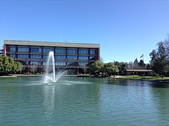 The Solano County Library in Fairfield
 Jelly Belly Headquarters - Fairfield, California
 Fairfield, California downtown


References
- "California Cities by Incorporation Date". California Association of Local Agency Formation Commissions. Archived from the original (Word) on November 3, 2014. Retrieved August 25, 2014.
- "City Government". City of Fairfield, CA. Archived from the original on December 26, 2018. Retrieved October 12, 2014.
- "City Council". City of Fairfield, CA. Archived from the original on January 23, 2016. Retrieved October 12, 2014.
- "Statewide Database". UC Regents. Retrieved November 5, 2014.
- "California's 3rd Congressional District - Representatives & District Map". Civic Impulse, LLC. Retrieved March 9, 2013.
- "2019 U.S. Gazetteer Files". United States Census Bureau. Retrieved July 1, 2020.
- "Fairfield". Geographic Names Information System. United States Geological Survey, United States Department of the Interior. Retrieved October 11, 2014.
- "Fairfield (city) QuickFacts". United States Census Bureau. Retrieved April 10, 2021.
- "ZIP Code(tm) Lookup". United States Postal Service. Retrieved November 9, 2014.
- "About Fairfield". Archived from the original on December 30, 2010. Retrieved January 7, 2011.
- "Hennessey Fire Information". CAL FIRE. Retrieved August 17, 2020.
- "Census of Population and Housing". Census.gov. Retrieved June 4, 2015.
- "2010 Census Interactive Population Search: CA - Fairfield city". U.S. Census Bureau. Archived from the original on July 15, 2014. Retrieved July 12, 2014.
- "U.S. Census website". United States Census Bureau. Retrieved 2008-01-31.
- "NOWData - NOAA Online Weather Data". National Oceanic and Atmospheric Administration. Retrieved June 26, 2022.
- "Extreme Temperatures Around the World Twitter". Retrieved September 6, 2022.
- Zuckerman, Sam (June 24, 2011). "Fairfield balances on the edge as housing prices plunge". The San Francisco Chronicle.
- "Fact sheet" (PDF). www.fairfield.ca.gov. 2021. Retrieved January 10, 2022.
- "City of Fairfield, CA - City Council". www.fairfield.ca.gov.
- "Fairfield Train Station Specific Plan". City of Fairfield. Retrieved November 13, 2017.
- Metropolitan Transportation Commission (December 1, 2008). "MTC Closes Funding Gap for New Fairfield-Vacaville Train Station". Archived from the original on December 7, 2008. Retrieved 2008-12-02.
- "City of Fairfield, CA - Sister City Program". City of Fairfield. Retrieved July 27, 2017.
- "Brad Bergesen Stats". Baseball Almanac. Retrieved December 3, 2012.
External links
 Fairfield, California travel guide from Wikivoyage
- Official website

- Fairfield-Suisun Chamber of Commerce
| Bodies of water |
|  |
|---|---|---|
| Counties | ||
| Major cities | ||
| Cities and towns 100k–250k | ||
| Cities and towns 50k–99k | ||
| Cities and towns 25k–50k | ||
| Cities and towns 10k–25k | ||
| Sub-regions |
| |
| ||
Municipalities and communities of Solano County, California, United States | ||
|---|---|---|
County seat: Fairfield | ||
| Cities |  | |
| CDPs | ||
| Unincorporated communities |
| |
| Ghost town |
| |
| ||
State of California | |
|---|---|
Sacramento (capital) | |
| Topics |
|
| Regions |
|
| Metro regions |
|
| Counties |
|
| Most populous cities | |
Places adjacent to Fairfield, California | ||||||||||||||||
|---|---|---|---|---|---|---|---|---|---|---|---|---|---|---|---|---|
| ||||||||||||||||
Authority control | |
|---|---|
| General | |
| National libraries | |
| Other | |
На других языках
[de] Fairfield (Kalifornien)
Fairfield ist eine Stadt im Solano County im US-Bundesstaat Kalifornien, Vereinigte Staaten, mit 105.446 Einwohnern (Stand 2006) und Sitz der County-Verwaltung. Das Stadtgebiet hat eine Größe von 97,6 km². Die Stadt liegt auf halber Strecke zwischen San Francisco und Sacramento und hat etwas weniger Einwohner als Vallejo, die andere Großstadt im County. Andere Städte in der Nähe sind Suisun City, Vacaville, Rio Vista, Benicia und Napa.- [en] Fairfield, California
[ru] Фэрфилд (Калифорния)
Фэ́рфилд (англ. Fairfield) — город в США в штате Калифорния, центр округа Солано. Расположен между городами Сан-Франциско и Сакраменто. Площадь — 97,475 км²[2].Другой контент может иметь иную лицензию. Перед использованием материалов сайта WikiSort.org внимательно изучите правила лицензирования конкретных элементов наполнения сайта.
WikiSort.org - проект по пересортировке и дополнению контента Википедии