world.wikisort.org - USA
Redding is the economic and cultural capital of the Shasta Cascade region of Northern California and the county seat of Shasta County. Redding lies along the Sacramento River, 162 miles (261 km) north of Sacramento, and 120 miles (190 km) south of California's northern border with Oregon. Its population is 95,542 as of the 2022 census, up from 89,861 from the 2010 census.
Redding, California | |
|---|---|
| City of Redding | |
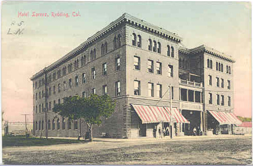
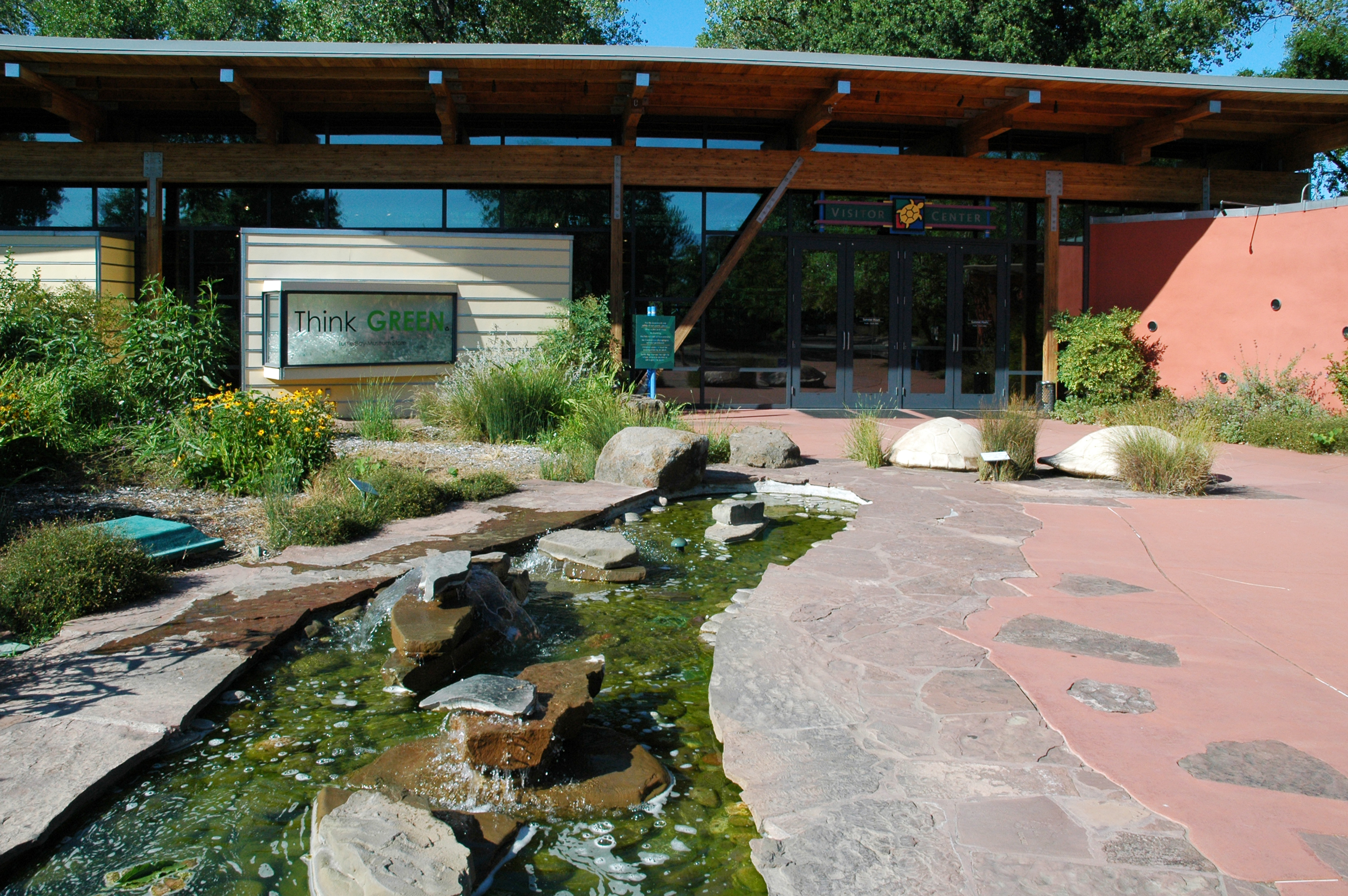
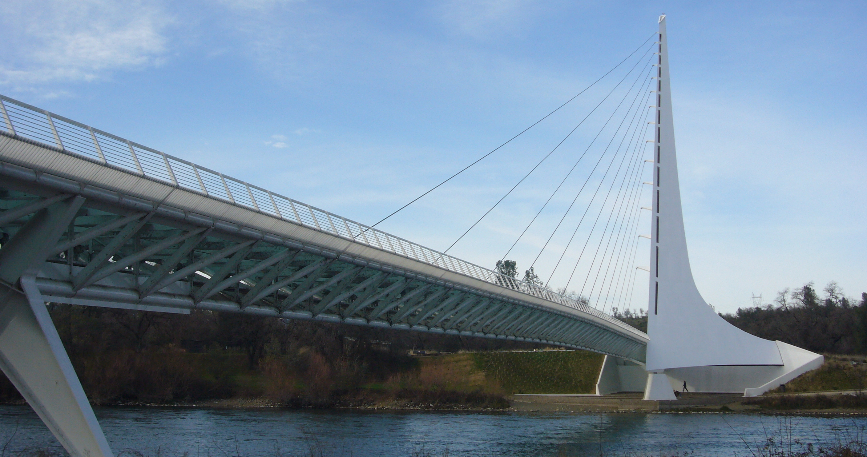     Top: Sundial Bridge at Turtle Bay; middle: Cascade Theatre, Hotel Lorenz; bottom: Old City Hall, Pine Street School | |
 Flag  Seal | |
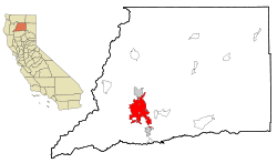 Location of Redding in Shasta County, California | |
 Redding Location in the United States  Redding Redding (the United States) | |
| Coordinates: 40°35′N 122°22′W | |
| Country | United States |
| State | California |
| County | Shasta |
| Incorporated | October 4, 1887 |
| Founded by | Pierson B. Reading |
| Government | |
| • Type | Council-manager |
| • City council | Mayor Kristen Schreder Vice Mayor Michael Dacquisto Erin Resner Julie Winter Mark Mezzano |
| • City manager | Barry Tippin |
| Area | |
| • Total | 61.17 sq mi (158.44 km2) |
| • Land | 59.65 sq mi (154.48 km2) |
| • Water | 1.53 sq mi (3.96 km2) 2.50% |
| Elevation | 564 ft (172 m) |
| Population (2020) | |
| • Total | 93,611 |
| • Rank | 82nd in California |
| • Density | 1,500/sq mi (590/km2) |
| Demonym | Reddingite |
| Time zone | UTC−8 (Pacific Time Zone) |
| • Summer (DST) | UTC−7 (PDT) |
| ZIP codes | 96001–96003, 96049, 96099 |
| Area code | 530 |
| FIPS code | 06-59920 |
| GNIS feature IDs | 277582, 2411531 |
| Website | Official website |
Etymology
During the Gold Rush, the area that now comprises Redding was called Poverty Flats.[3] In 1868 the first land agent for the Central Pacific Railroad, a former Sacramento politician named Benjamin Bernard Redding, bought property in Poverty Flats on behalf of the railroad so that it could build a northern terminus there. In the process of building the terminus, the railroad also built a town in the same area, which they named Redding in honor of Benjamin Redding.
In 1874 there was a dispute over the name by local legislators and it was changed for a time to Reading, in order to honor Pierson B. Reading, who arrived in the area in 1843, owned the Buenaventura land grant on which Redding sits, and had died only a few years before, in 1868. The name was officially changed back to Redding by 1880.[4][5]
History
Indigenous culture
Before European settlers came to the area, it was inhabited by a tribe of Native Americans called the Wintu. At their height, the Wintu had as many as 239 villages in the Shasta County area.[6]
Spanish and Mexican eras
Although Europeans had been to California as early as 1542, when Juan Cabrillo sailed to what is now the San Diego Bay, the indigenous natives were probably the only inhabitants of far Northern California region until Russian fur trappers came through the area in 1815.
The first European settlement in the area was established in 1844 by Pierson B. Reading, an early California pioneer who received a Rancho Buena Ventura Mexican land grant for 26,632 acres (10,778 ha) that is now covered by Redding and Cottonwood, California. At the time, it was the northernmost nonnative settlement in California.
Gold Rush era
During the Gold Rush, 49ers found gold to the north on Rock, Middle and Salt creeks, near Shasta, California, and to the south along Oregon and Olney creeks but the area that is now Redding was poor placer gold ground and called Poverty Flats. In 1868 the first land agent for the Central Pacific Railroad, a former Sacramento politician named Benjamin B. Redding, bought property in Poverty Flats on behalf of the railroad for a northern terminus, which the tracks reached in 1872. In the process of building the terminus, the railroad also built the town of Redding which was officially incorporated on October 4, 1887. In 1888, Redding won the county seat from Shasta.[7]
20th century

In the early twentieth century the town's economic growth was spurred by the significant copper and iron mineral extraction industry nearby. The mining industry eventually declined, causing the economy and population to falter by 1920. It recovered in the thirties as the economy boomed due to the construction of Shasta Dam to the northwest. The building of the dam, which was completed in 1945, caused Redding's population to nearly double, also spurring the growth and development of other towns in the area.[8]

Redding continued to grow steadily in the 1950s due to the region's growing lumber industry and tourism brought about by the newly completed dam. The constructions of Whiskeytown and Keswick dams also helped boost the economy by bringing new workers to the area. Interstate 5 was built during the sixties and seventies, which added to development and tourism in the region.
Growth in Redding during the 1960s and 1970s was further spurred by the annexation of an area east of the Sacramento River that included the unincorporated community of Enterprise; the residents voted to support the annexation primarily to acquire less expensive electricity via Redding's municipal utility, which receives power from the dam.
During the 1970s, the lumber industry suffered from decline. In the early 1990's Lumber mills in the area closed down due to the preservation of the living habitat of the Spotted Owl. This heavily impacted the Redding area. The economy picked up, due to a retail and housing boom in the late 1980s that continued until the mid-1990s.
21st century
In 2017, the city adopted a new flag after holding a redesign contest.[9]
The 21st century has also seen a number of devastating wildfires near and in Redding. In 1999, the Jones Fire destroyed over 100 structures, followed by the Bear Fire in 2004. In late July 2018, the Carr Fire in Shasta County seriously impacted the Redding area with the destruction of at least 1,100[10] buildings, with several thousand more threatened, 38,000 people instructed to evacuate and 6 deaths.[11] Most recently, the Fawn Fire in 2021 also resulted in the evacuation of over 4,000 people and the destruction of 185 buildings.
Geography
According to the United States Census Bureau, the city has a total area of 61.2 square miles (159 square kilometers). 59.6 square miles (154 km2) of it is land, and 1.5 square miles (3.9 km2) of it (2.50%) is beneath water.

Redding is located at the very northwestern end of the Central Valley, which transitions into the Cascade foothills. The city is surrounded by mountains to the north, east, and west and fertile farm land to the south. Outermost parts of the city are part of the Cascade foothills, whereas southern and central areas are in the Sacramento Valley.[citation needed]
The elevation in Redding is 495 feet (151 meters) on average, whereas anywhere to the north, east, or west of downtown ranges between 550 feet (170 m) and 800 feet (240 m) feet. Southern portions range between 400 feet (120 m) and 500 feet (150 m).

The Shasta Dam on the Sacramento River provides a considerable level of flood protection for Redding. The dam is capable of controlling flows up to 79,000 cubic feet (7,300 cubic meters) per second. The flow rate exceeded this threshold in both 1970 and 1974.[12]
Soils in and around town are composed mostly of clay or gravelly loam texture, with red or brown mineral horizons. They are slightly or moderately acidic in their natural state.[13]
There are several rare and endangered species in Redding and its immediate vicinity. The Redding Redevelopment Plan EIR notes the California State listed endangered species, slender Orcutt grass (Orcuttia tenuis), occurs in eastern Redding near the municipal airport, where vernal pools are known to exist. This endemic grass is a Federal Candidate for listing and is endangered throughout its range, confined to several populations, and seriously threatened by agriculture, overgrazing, and residential development. Vernal pools provide the preferred habitat for this plant, which the California Native Plant Society considers a rare and endangered species. These same vernal pools also support federally protected species such as the federally threatened vernal pool fairy shrimp (Branchinecta lynchi).
Climate

Redding has a hot-summer Mediterranean climate (Köppen: Csa), with very hot, dry summers and cool, wet winters. Redding is known for very high summer temperatures, despite being located just north of the 40th Parallel North. Winter (October–April) provides the most precipitation of any season in Redding—the weather tends to be either rainy or foggy and at times, snow occurs. While summers are mostly hot and dry, thunderstorms are not uncommon. The average daily maximum temperature in July stays near 100 °F (37.8 °C). The highest official recorded temperature in Redding was 118 °F (48 °C) on July 20, 1988, recorded at the nearby Redding Regional Airport and the most recent of three occasions; however, some residents say they recall a high temperature of 121 in the summer of 1981 and even just recently, 126 in the summer of 2020.[14] Redding has an average possible sunshine of 88%, the second-highest percentage (after Yuma, Arizona) of any US city.[15]
Summer overnight lows are unusually warm by Sacramento Valley standards and average warmer than coastal towns' daytime highs. The warmest night annually averages 79 °F (26 °C).[14] Since the station opened in 1986, the hottest night was 86 °F (30 °C) in June 2004.[14] Redding's warm summer days and nights compared to areas further south are a result of a greater distance to maritime influences than the lower end of the valley.
Redding occasionally receives snow, though it has received as much as 23 inches (58 centimeters) of snow in a single storm, occurring on December 4–7, 1909 and December 22–24, 1968, including 16 in (41 cm) on December 23, 1968, the most in any calendar day on record.[14] It rarely gets sleet or freezing rain. Frost occurs commonly in December through February, less often in March or November. In spring, rain is common. The city is located near the foothills of the Cascade and Klamath mountain ranges and it therefore gets much more rain than most places in the Sacramento Valley; temperature differentials between land and sea cause moist air from the latter to flow over the southern Sacramento valley during the summer months, producing intense heat in Redding. The direction of this winds switches from the north and east in the summer, as hot, high-pressure air flows from land to sea, making the area very dry. Tornadoes are extremely rare; flooding occurs only around the area near the Sacramento River. The coldest temperature recorded in Redding was 16 °F (−9 °C) on January 17, 2012, and December 9, 2009.[14] The coldest daytime high of the year is averaging 41 °F (5 °C) and the lowest on record is 29 °F (−2 °C) in 1990, which remains the latest year to record an ice day.[14]
| Climate data for Redding Regional Airport, California (1991–2020 normals,[lower-alpha 1] extremes 1893–present[lower-alpha 2]) | |||||||||||||
|---|---|---|---|---|---|---|---|---|---|---|---|---|---|
| Month | Jan | Feb | Mar | Apr | May | Jun | Jul | Aug | Sep | Oct | Nov | Dec | Year |
| Record high °F (°C) | 87 (31) |
87 (31) |
93 (34) |
98 (37) |
109 (43) |
117 (47) |
118 (48) |
118 (48) |
116 (47) |
106 (41) |
99 (37) |
83 (28) |
118 (48) |
| Mean maximum °F (°C) | 70.5 (21.4) |
74.3 (23.5) |
80.7 (27.1) |
88.0 (31.1) |
97.4 (36.3) |
106.5 (41.4) |
110.5 (43.6) |
108.2 (42.3) |
104.9 (40.5) |
94.9 (34.9) |
79.8 (26.6) |
68.9 (20.5) |
112.0 (44.4) |
| Average high °F (°C) | 57.2 (14.0) |
61.0 (16.1) |
65.7 (18.7) |
71.8 (22.1) |
82.0 (27.8) |
91.9 (33.3) |
99.9 (37.7) |
98.1 (36.7) |
92.3 (33.5) |
79.4 (26.3) |
64.4 (18.0) |
56.0 (13.3) |
76.6 (24.8) |
| Daily mean °F (°C) | 47.5 (8.6) |
50.5 (10.3) |
54.4 (12.4) |
59.4 (15.2) |
68.2 (20.1) |
77.1 (25.1) |
83.4 (28.6) |
81.0 (27.2) |
75.3 (24.1) |
64.8 (18.2) |
52.9 (11.6) |
46.6 (8.1) |
63.4 (17.4) |
| Average low °F (°C) | 37.7 (3.2) |
40.1 (4.5) |
43.2 (6.2) |
47.0 (8.3) |
54.3 (12.4) |
62.4 (16.9) |
67.0 (19.4) |
63.9 (17.7) |
58.2 (14.6) |
50.2 (10.1) |
41.5 (5.3) |
37.2 (2.9) |
50.2 (10.1) |
| Mean minimum °F (°C) | 27.0 (−2.8) |
28.8 (−1.8) |
32.0 (0.0) |
34.5 (1.4) |
42.6 (5.9) |
51.3 (10.7) |
58.0 (14.4) |
56.1 (13.4) |
48.9 (9.4) |
39.1 (3.9) |
29.7 (−1.3) |
25.7 (−3.5) |
23.5 (−4.7) |
| Record low °F (°C) | 16 (−9) |
20 (−7) |
27 (−3) |
28 (−2) |
31 (−1) |
38 (3) |
48 (9) |
44 (7) |
39 (4) |
29 (−2) |
21 (−6) |
16 (−9) |
16 (−9) |
| Average precipitation inches (mm) | 6.04 (153) |
5.48 (139) |
4.62 (117) |
2.41 (61) |
1.81 (46) |
0.75 (19) |
0.07 (1.8) |
0.13 (3.3) |
0.45 (11) |
1.92 (49) |
3.53 (90) |
6.31 (160) |
33.52 (851) |
| Average snowfall inches (cm) | 1.5 (3.8) |
0.2 (0.51) |
0.2 (0.51) |
0.0 (0.0) |
0.2 (0.51) |
0.0 (0.0) |
0.0 (0.0) |
0.0 (0.0) |
0.0 (0.0) |
0.0 (0.0) |
0.0 (0.0) |
2.0 (5.1) |
4.1 (10.43) |
| Average precipitation days (≥ 0.01 in) | 12.2 | 10.9 | 11.7 | 8.1 | 6.1 | 2.9 | 0.5 | 0.6 | 1.4 | 4.7 | 8.8 | 12.6 | 80.6 |
| Source 1: NOAA[14][17] | |||||||||||||
| Source 2: WRCC[18] | |||||||||||||
Demographics
| Historical population | |||
|---|---|---|---|
| Census | Pop. | %± | |
| 1880 | 600 | — | |
| 1890 | 1,821 | 203.5% | |
| 1900 | 2,946 | 61.8% | |
| 1910 | 3,572 | 21.2% | |
| 1920 | 2,962 | −17.1% | |
| 1930 | 4,188 | 41.4% | |
| 1940 | 8,109 | 93.6% | |
| 1950 | 10,256 | 26.5% | |
| 1960 | 12,773 | 24.5% | |
| 1970 | 16,659 | 30.4% | |
| 1980 | 42,103 | 152.7% | |
| 1990 | 66,462 | 57.9% | |
| 2000 | 80,865 | 21.7% | |
| 2010 | 89,861 | 11.1% | |
| 2020 | 93,611 | 4.2% | |
| U.S. Decennial Census[19] | |||

The 2010 United States Census[20] reported that Redding had a population of 89,861. The population density was 1,468.9 inhabitants per square mile (567.1/km2). The racial makeup of Redding was 77,117 (85.8%) White, 1,092 (1.2%) African American, 2,034 (2.3%) Native American, 3,034 (3.4%) Asian, 156 (0.2%) Pacific Islander, 2,307 (2.6%) from other races, and 4,121 (4.6%) from two or more races. There were 7,787 people of Hispanic or Latino origin, of any race (8.7%).
The Census reported that 87,841 people (97.8% of the population) lived in households, 1,138 (1.3%) lived in non-institutionalized group quarters, and 882 (1.0%) were institutionalized.
There were 36,130 households, out of which 11,012 (30.5%) had children under the age of 18 living in them, 16,001 (44.3%) were married couples living together, 4,806 (13.3%) had a female householder with no husband present, 1,984 (5.5%) had a male householder with no wife present. There were 2,570 (7.1%) unmarried opposite-sex partnerships, and 204 (0.6%) same-sex married couples or partnerships. 10,344 households (28.6%) were made up of individuals, and 4,622 (12.8%) had someone living alone who was 65 years of age or older. The average household size was 2.43. There were 22,791 families (63.1% of all households); the average family size was 2.94.
The population was spread out, with 20,518 people (22.8%) under the age of 18, 9,436 people (10.5%) aged 18 to 24, 21,725 people (24.2%) aged 25 to 44, 23,424 people (26.1%) aged 45 to 64, and 14,758 people (16.4%) who were 65 years of age or older. The median age was 38.5 years. For every 100 females, there were 93.8 males. For every 100 females age 18 and over, there were 90.4 males.
There were 38,679 housing units at an average density of 632.3 per square mile (244.1/km2), of which 19,968 (55.3%) were owner-occupied, and 16,162 (44.7%) were occupied by renters. The homeowner vacancy rate was 2.3%; the rental vacancy rate was 6.9%. 48,179 people (53.6% of the population) lived in owner-occupied housing units and 39,662 people (44.1%) lived in rental housing units.
Economy

Redding is the economic hub of the Shasta Cascade region of Northern California.
The Redding Metropolitan Statistical Area (MSA) was recognized as the 29th Most Dynamic MSA in the United States in 2019 by the Walton Family Foundation.[21] Redding was recognized for having a diversified economy with several large employers in different sectors.
Top employers
According to the city's 2016 Comprehensive Annual Financial Report,[22] the top employers in Redding are:
| # | Employer | # of employees |
|---|---|---|
| 1 | Mercy Medical Center | 1,832 |
| 2 | Shasta County | 1,750 |
| 3 | City of Redding | 1,129 |
| 4 | Shasta Regional Medical Center | 856 |
| 5 | CA Transportation Department | 663 |
| 6 | Redding Rancheria | 523 |
| 7 | Wal-Mart | 450 |
| 8 | Shasta Union High School District | 406 |
| 9 | Shasta College | 352 |
| 10 | Blue Shield of California | 330 |
Government

State and federal representation
In the California State Legislature, Redding is in the 1st Senate District, represented by Republican Brian Dahle,[23] and the 1st Assembly District, represented by Republican Megan Dahle.[24]
In the United States House of Representatives, Redding is in California's 1st congressional district, represented by Republican Doug LaMalfa.[25]
Municipal government
The city council is composed of Mayor Erin Resner, Vice Mayor Kristen Schreder, Julie Winter, Michael Dacquisto, and Mark Mezzano.[26][27] The city manager is Barry Tippin.[28]
Redding is a general law city operating under the council-manager form of government.[27]
Parks and recreation


Museums and public art
- Sculpture park at City Hall
- Sundial Bridge at Turtle Bay, by Santiago Calatrava
- Santiago Calatrava sculpture, at Domke Plaza[29]
- Shasta Historical Society
Architecture
- Hotel Lorenz
- Pilgrim Congregational Church
Venues
- Cascade Theatre
- The Dip
- Riverfront Amphitheater
- Old City Hall
- Redding Civic Auditorium[30]
Performing arts
- Riverfront Playhouse
- Axiom Repertory Theater
Education


Higher education
Public
- Shasta College
Private
- National University
- Shasta Bible College and Graduate School
- Simpson University
High schools
Public
- Shasta High School
- Enterprise High School
- Foothill High School
- Pioneer High School
Secondary
- Freedom High School
- University Preparatory School
- North State Independence High School
- Redding Christian High School
- Liberty Christian High School
Charter schools
- Chrysalis Charter School
- Monarch Learning Center
- Stellar Charter School
- Phoenix Charter Academy
- Redding Collegiate Academy
- Redding School of the Arts
- Rocky Point Charter School
- Shasta Charter Academy
Trade schools
- Redding Institute of Technology
- Shasta School of Cosmetology
- CloudWise Academy
Media
- Redding Record Searchlight
- After Five
Television
Radio
Transportation

Major highways
 Interstate 5 runs through the east central portion of Redding.
 CA 299, formerly
  U.S. 299, runs through the western, central, and northeastern parts of the city.
 CA 44 runs through the middle and eastern part of town. Its western terminus is at Market Street (California 273) in downtown Redding.
 CA 273, formerly the Interstate 5 Business Route and also formerly
  U.S. 99, runs through the city.
Rail and bus transportation
Amtrak, the national passenger rail system, provides service to Redding station, operating its Coast Starlight daily in both directions between Seattle, Washington, and Los Angeles, California VA Portland, Oregon; Sacramento, California; Oakland, California; San Jose, California; Santa Barbara, California and all Intermediate station stops. Amtrak California also provides Thruway Motorcoach service to Stockton or Sacramento for connections to the San Joaquins, which serve the San Francisco Bay Area, San Joaquin Valley and the Los Angeles area via bus connections.
Redding provides a city bus transportation system called RABA (Redding Area Bus Authority). RABA provides routes throughout the City of Redding and also provides transportation throughout Redding's suburbs. Transportation is also available by RABA to Burney, by Sage Stage to Alturas and by Trinity Transit to Weaverville.[31] Redding is also served by the intercity bus companies Greyhound and Fronteras del Norte.[citation needed]
Shasta Regional Transportation Agency is developing a weekday commuter bus from Redding to the Sacramento Valley Station.[32]
Air transportation
Air transportation for the Redding area is provided by two general aviation airports. Redding Regional Airport, located south of Redding, has scheduled flights from SkyWest (United Express) and Avelo Airlines. The smaller Benton Airpark is located on the western side of Redding.
Notable people
This list includes notable persons who were born/raised/worked in, lived in, or whose identity was significantly influenced by Redding, as well as music groups that were founded in the area.
- Ashley Parker Angel – recording artist and actor
- David de Berry – theater composer and actor
- Shane Drake – music video director
- Francesca Eastwood – actor
- Rich Eisen – sportscaster
- Kathleen Kennedy – film producer
- Matthew Kennedy – author
- Tom Meyer – professor, speaker, and author
- Kevin Rose – Internet entrepreneur
- Cory Asbury – contemporary Christian singer
- Duffy Bishop – electric blues singer and songwriter
- Brian Johnson - contemporary worship singer and songwriter
- Randy Miller – drummer of The Myriad
- Craig Padilla – ambient electronic musician and film score composer
- Jessica Pratt – singer/ songwriter
- Roy Rogers – guitarist
- Rick Bosetti – professional baseball player
- Greg Cadaret – MLB player
- Mel Hein – football player, 1938 MVP, NFL Hall of Fame inductee
- Paul Howard – former NFL player
- Eddie Machen – heavyweight boxer
- Buck Martinez – professional MLB player, manager, broadcaster
- Matt Nichols – Canadian Football League player
- Ryan O'Callaghan – NFL football player
- Hilary Pecis (born 1979) – artist[33]
- Bill Plummer – MLB player, coach and manager
- Megan Rapinoe – professional soccer player, Olympic gold medalist
- Ricky Ray – football player in the Canadian Football League
- Lynne Roberts – college basketball coach
- Jason Sehorn – former NFL player
- John Strohmayer – former MLB player and high school coach
- Raymond Jacobs – US Marine, said to be in photo of first flag raised on Iwo Jima
- Brian Sandoval – 29th governor of Nevada
- Sam Butcher – artist, Precious Moments, Inc.
- Jeffery Dangl – plant immunologist
- Bill Johnson – Christian minister and evangelist
- Ruggles brothers – stagecoach robbers
- Michael Zagaris – sports and music photographer
See also
- Bethel Church (Redding, California)
Notes
- Mean monthly maxima and minima (i.e. the expected highest and lowest temperature readings at any point during the year or given month) calculated based on data at said location from 1991 to 2020.
- Records for Redding observed at:[16]
- Redding Weather Service Office, January 1893–April 1929
- Benton Field, May 1929–July 1944
- Two differing fire stations, August 1944–August 1986
- Redding Regional Airport since September 1986
References
- "2019 U.S. Gazetteer Files". United States Census Bureau. Retrieved July 1, 2020.
- "Redding". Geographic Names Information System. United States Geological Survey, United States Department of the Interior. Retrieved November 22, 2014.
- Donion, Preston (October 4, 2022). "City of Redding turns 135 years old". KRCR. Retrieved October 6, 2022.
- "How Redding got its Name". Archived from the original on March 28, 2016. Retrieved August 25, 2017.
- Peterson, Edward (1964). In the Shadow of the Mountain, a Short History of Shasta County, California. Redding, California: Edward Peterson. pp. passim. Retrieved July 21, 2020.
- Papers On Wintu Ethnography : 239 Wintu Villages In Shasta County Circa 1850. Redding, CA: Redding Museum and Art Center. 1980.
- "California Cities by Incorporation Date". California Association of Local Agency Formation Commissions. Archived from the original (Word) on November 3, 2014. Retrieved August 25, 2014.
- "Historic Redding California". Retrieved August 27, 2017.
- "City of Redding Flag". Archived from the original on December 27, 2017. Retrieved August 19, 2017.
- "Carr Fire Incident Update 7/29/18 PM" (PDF). Archived from the original (PDF) on July 30, 2018. Retrieved July 30, 2018.
- "'Terrifying' tornadoes of flame leave 2 dead as inferno destroys Californian city of Redding". The Daily Telegraph. London. July 28, 2018. Retrieved July 28, 2018.
- Environmental Impact Report for the Redding Redevelopment Plan, Earth Metrics, City of Redding and California State Clearinghouse Report (1990)
- "Web Soil Survey". Websoilsurvey.nrcs.usda.gov. Retrieved February 28, 2016.
- "NOWData – NOAA Online Weather Data". W2.weather.gov. Retrieved July 16, 2020.
- "NOAA". noaa.gov. Retrieved November 19, 2017.
- "Threaded Station Extremes". Retrieved June 2, 2021.
- "CA REDDING REGIONAL AP". National Oceanic and Atmospheric Administration. Retrieved July 16, 2020.
- "Western Regional Climate Center Data". wrcc.dri.edu. Retrieved September 18, 2022.
- "Census of Population and Housing". Census.gov. Retrieved June 4, 2015.
- "2010 Census Interactive Population Search: CA – Redding city". U.S. Census Bureau. Archived from the original on July 15, 2014. Retrieved July 12, 2014.
- Janiszewski, Erik (June 11, 2019). "PRESS RELEASE: REDDING MSA RECOGNIZED ONCE AGAIN". Shasta EDC. Retrieved April 27, 2020.
- "Comprehensive Annual Financial Report". cityofredding.org. Retrieved December 16, 2017.
- "Senators". State of California. Retrieved March 10, 2013.
- "Members Assembly". State of California. Retrieved March 2, 2013.
- "California's 1st Congressional District - Representatives & District Map". Civic Impulse, LLC. Retrieved March 1, 2013.
- "City Council Information | City of Redding". www.cityofredding.org. Retrieved February 21, 2020.
- "City Council Information". City of Redding. Archived from the original on December 6, 2015. Retrieved November 12, 2016.
- "Redding's City Manager". City of Redding. Archived from the original on February 20, 2015. Retrieved March 7, 2015.
- "New plaza to open at Sundial Bridge in time for Celebrate 10". Redding Record Searchlight. April 30, 2014. Retrieved November 2, 2020.
- https://www.reddingcivic.com/ [bare URL]
- "Modoc County, California : Redding". Sagestage.com. January 30, 2014. Retrieved February 28, 2016.
- "Shasta Intercity Bus Transportation Studies | Shasta Regional Transportation Agency, CA".
- "Hilary Pecis Brings Still-Life Art to Rockefeller Center". www.rockefellercenter.com.
External links
- Official website
- "Redding, California". C-SPAN Cities Tour. May 2017.
Places adjacent to Redding, California | ||||||||||||||||
|---|---|---|---|---|---|---|---|---|---|---|---|---|---|---|---|---|
| ||||||||||||||||
Shasta Cascade | ||
|---|---|---|
| Mountains |  | |
| Bodies of Water | ||
| Rivers | ||
| Incorporated Cities | ||
| Counties | ||
| Parks |
| |
Municipalities and communities of Shasta County, California, United States | ||
|---|---|---|
County seat: Redding | ||
| Cities |  | |
| CDPs |
| |
| Unincorporated communities |
| |
| Indian reservations |
| |
| Ghost towns |
| |
| Footnotes | ‡This populated place also has portions in an adjacent county or counties | |
| ||
Authority control | |
|---|---|
| General | |
| National libraries | |
| Other |
|
На других языках
[de] Redding (Kalifornien)
Redding ist eine Stadt im Shasta County im US-Bundesstaat Kalifornien mit rund 93.611 Einwohnern (Stand 2020) und Sitz der County-Verwaltung. Das Stadtgebiet umfasst eine Fläche von 154,4 Quadratkilometern und ist darüber hinaus ein wichtiger Verkehrsknotenpunkt im nördlichen Teil Kaliforniens abseits der Küste.- [en] Redding, California
[ru] Реддинг (Калифорния)
Ре́ддинг (англ. Redding) — город на севере штата Калифорния, США. Административный центр округа Шаста.Другой контент может иметь иную лицензию. Перед использованием материалов сайта WikiSort.org внимательно изучите правила лицензирования конкретных элементов наполнения сайта.
WikiSort.org - проект по пересортировке и дополнению контента Википедии