world.wikisort.org - USA
Amador County (/ˈæmədɔːr/ (![]() listen)) is a county located in the U.S. state of California, in the Sierra Nevada. As of the 2020 census, the population was 40,474.[4] The county seat is Jackson.[5] Amador County, located within California's Gold Country, is known as "The Heart of the Mother Lode". There is a substantial viticultural industry in the county.
listen)) is a county located in the U.S. state of California, in the Sierra Nevada. As of the 2020 census, the population was 40,474.[4] The county seat is Jackson.[5] Amador County, located within California's Gold Country, is known as "The Heart of the Mother Lode". There is a substantial viticultural industry in the county.
Amador County, California | |
|---|---|
County | |
 The Amador County foothills in April 2007 | |
 Flag  Seal | |
| Nickname: "The Heart of the Mother Lode" | |
 Interactive map of Amador County | |
 Location in the state of California | |
| Country | United States |
| State | California |
| Region | Sierra Nevada |
| Incorporated | May 1, 1854[1] |
| Named for | José María Amador |
| County seat | Jackson |
| Largest city | Ione (population and area) |
| Government | |
| • Type | Council–CAO |
| • Body | Board of Supervisors[2]
|
| • Chair | Jeff Brown |
| • Vice Chair | Linda Rianda |
| • County Administrative Officer | Chuck Iley |
| Area | |
| • Total | 606 sq mi (1,570 km2) |
| • Land | 595 sq mi (1,540 km2) |
| • Water | 11.4 sq mi (30 km2) |
| Highest elevation | 9,414 ft (2,869 m) |
| Population (2020) | |
| • Total | 40,474 |
| • Density | 67/sq mi (26/km2) |
| Time zone | UTC-8 (Pacific Time Zone) |
| • Summer (DST) | UTC-7 (Pacific Daylight Time) |
| Area code | 209 |
| FIPS code | 06-005 |
| GNIS feature ID | 1675841 |
| Website | www |
History


![The former Amador County Courthouse consists of two buildings: the second courthouse (built 1864) and the Hall of Records (1893), that were enclosed and combined in 1939 with an Art Deco exterior.[6]](http://upload.wikimedia.org/wikipedia/commons/a/ab/2009-0724-CA-Jackson-AmadorCtyCourt.jpg)

Amador County was created by the California Legislature on May 11, 1854, from parts of Calaveras and El Dorado counties.[7] It was organized on July 3, 1854.[7] In 1864, part of the county's territory was given to Alpine County.
The county is named for José María Amador, a soldier, rancher, and miner, born in San Francisco in 1794,[8] the son of Sergeant Pedro Amador (a Spanish soldier who settled in California in 1771) and younger brother to Sinforosa Amador.
In 1848, Jose Maria Amador, with several Native Americans, established a successful gold mining camp near the present town of Amador City. In Spanish, the word amador means "one who loves". Some of the Mother Lode's most successful gold mines were located in Amador County, including the Kennedy, Argonaut, and Keystone.
There are numerous gold mines in Amador County including the Argonaut Mine, the Kennedy Mine, the Central Eureka, and the Lincoln. The Kennedy Mine in Jackson was the deepest gold mine of its time. The federal government closed all of the Mother Lode's mines in 1942 because they were considered non-essential to the war effort.[citation needed]
Geography
According to the U.S. Census Bureau, the county has a total area of 606 square miles (1,570 km2), of which 595 square miles (1,540 km2) is land and 11.4 square miles (30 km2) (1.9%) is water.[9] It is the fifth-smallest county in California by land area and second-smallest by total area. Water bodies in the county include Lake Amador, Lake Camanche, Pardee Reservoir, Bear River Reservoir, Silver Lake, Sutter Creek, Cosumnes River, Mokelumne River, and Lake Tabeaud. Thirty-seven miles of the North Fork and main Mokelumne River were added to the California Wild and Scenic Rivers System on June 27, 2018, when Governor Edmund G. "Jerry" Brown signed Senate Bill 854.
Amador County is located approximately 45 miles (72 km) southeast of Sacramento in the part of California known as the Mother Lode, or Gold Country in the Sierra Nevada.
Amador County ranges in elevation from approximately 250 feet (76 m) in the western portion of the county to over 9,000 feet (2,700 m) in the eastern portion of the county, the tallest point being Thunder Mountain. The county is bordered on the north by the Cosumnes River and El Dorado County and on the south by the Mokelumne River and Calaveras County, on the west by Sacramento and San Joaquin Counties, and the east by Alpine County.
Adjacent counties
- El Dorado County – north
- Alpine County – east
- Calaveras County – south
- San Joaquin County – southwest
- Sacramento County – west
National protected area
- Eldorado National Forest (part)
- Mokelumne Wilderness (part)
Demographics
| Historical population | |||
|---|---|---|---|
| Census | Pop. | %± | |
| 1860 | 10,930 | — | |
| 1870 | 9,582 | −12.3% | |
| 1880 | 11,384 | 18.8% | |
| 1890 | 10,320 | −9.3% | |
| 1900 | 11,116 | 7.7% | |
| 1910 | 9,086 | −18.3% | |
| 1920 | 7,793 | −14.2% | |
| 1930 | 8,494 | 9.0% | |
| 1940 | 8,973 | 5.6% | |
| 1950 | 9,151 | 2.0% | |
| 1960 | 9,990 | 9.2% | |
| 1970 | 11,821 | 18.3% | |
| 1980 | 19,314 | 63.4% | |
| 1990 | 30,039 | 55.5% | |
| 2000 | 35,100 | 16.8% | |
| 2010 | 38,091 | 8.5% | |
| 2020 | 40,474 | 6.3% | |
| U.S. Decennial Census[10] 1790–1960[11] 1900–1990[12] 1990–2000[13] 2010[14] 2020[15] | |||
2020 census
| Race / Ethnicity | Pop 2010[14] | Pop 2020[15] | % 2010 | % 2020 |
|---|---|---|---|---|
| White alone (NH) | 30,325 | 29,725 | 79.61% | 73.44% |
| Black or African American alone (NH) | 938 | 1,215 | 2.46% | 3.00% |
| Native American or Alaska Native alone (NH) | 547 | 577 | 1.44% | 1.43% |
| Asian alone (NH) | 396 | 554 | 1.04% | 1.37% |
| Pacific Islander alone (NH) | 63 | 73 | 0.17% | 0.18% |
| Some Other Race alone (NH) | 130 | 249 | 0.34% | 0.62% |
| Mixed Race/Multi-Racial (NH) | 936 | 2,067 | 2.46% | 5.11% |
| Hispanic or Latino (any race) | 4,756 | 6,014 | 12.49% | 14.86% |
| Total | 38,091 | 40,474 | 100.00% | 100.00% |
Note: the US Census treats Hispanic/Latino as an ethnic category. This table excludes Latinos from the racial categories and assigns them to a separate category. Hispanics/Latinos can be of any race.
2011
| Population, race, and income | |||||
|---|---|---|---|---|---|
| Total population[16] | 38,244 | ||||
| White[16] | 33,454 | 87.5% | |||
| Black or African American[16] | 870 | 2.3% | |||
| American Indian or Alaska Native[16] | 889 | 2.3% | |||
| Asian[16] | 529 | 1.4% | |||
| Native Hawaiian or other Pacific Islander[16] | 82 | 0.2% | |||
| Some other race[16] | 1,432 | 3.7% | |||
| Two or more races[16] | 988 | 2.6% | |||
| Hispanic or Latino (of any race)[17] | 4,677 | 12.2% | |||
| Per capita income[18] | $28,030 | ||||
| Median household income[19] | $56,180 | ||||
| Median family income[20] | $69,521 | ||||
Places by population, race, and income
| Place | Type[21] | Population[16] | White[16] | Other[16] [note 1] |
Asian[16] | Black or African American[16] |
Native American[16] [note 2] |
Hispanic or Latino (of any race)[17] |
|---|---|---|---|---|---|---|---|---|
| Amador City | City | 158 | 100.0% | 0.0% | 0.0% | 0.0% | 0.0% | 0.0% |
| Buckhorn | CDP | 2,090 | 98.4% | 1.6% | 0.0% | 0.0% | 0.0% | 5.6% |
| Buena Vista | CDP | 435 | 68.5% | 25.1% | 0.0% | 0.0% | 6.4% | 0.0% |
| Camanche North Shore | CDP | 791 | 96.7% | 3.3% | 0.0% | 0.0% | 0.0% | 16.9% |
| Camanche Village | CDP | 704 | 100.0% | 0.0% | 0.0% | 0.0% | 0.0% | 0.0% |
| Drytown | CDP | 138 | 100.0% | 0.0% | 0.0% | 0.0% | 0.0% | 0.0% |
| Fiddletown | CDP | 121 | 100.0% | 0.0% | 0.0% | 0.0% | 0.0% | 0.0% |
| Ione | City | 7,873 | 70.7% | 14.6% | 2.6% | 9.7% | 2.4% | 25.3% |
| Jackson† | City | 4,626 | 90.7% | 4.8% | 1.2% | 0.8% | 2.5% | 16.6% |
| Kirkwood‡ | CDP | 158 | 96.8% | 0.0% | 0.6% | 2.5% | 0.0% | 0.0% |
| Martell | CDP | 140 | 100.0% | 0.0% | 0.0% | 0.0% | 0.0% | 0.0% |
| Pine Grove | CDP | 2,573 | 93.0% | 5.9% | 1.1% | 0.0% | 0.0% | 7.3% |
| Pioneer | CDP | 1,226 | 82.1% | 2.6% | 0.0% | 0.0% | 15.3% | 0.0% |
| Plymouth | City | 1,055 | 94.0% | 3.2% | 0.6% | 0.0% | 2.2% | 11.7% |
| Red Corral | CDP | 1,757 | 84.4% | 11.8% | 2.3% | 0.2% | 1.4% | 2.9% |
| River Pines | CDP | 578 | 97.1% | 0.0% | 2.9% | 0.0% | 0.0% | 6.9% |
| Sutter Creek | City | 2,497 | 93.4% | 1.5% | 4.8% | 0.0% | 0.3% | 5.3% |
| Volcano | CDP | 184 | 99.4% | 0.0% | 0.6% | 0.0% | 0.0% | 0.0% |
† County seat
‡ Data for Amador County area of this CDP
| Place | Type[21] | Population[22] | Per capita income[18] | Median household income[19] | Median family income[20] |
|---|---|---|---|---|---|
| Amador City | City | 158 | $36,439 | $63,036 | $81,500 |
| Buckhorn | CDP | 2,090 | $31,611 | $50,365 | $54,833 |
| Buena Vista | CDP | 435 | $12,573 | $32,944 | $33,444 |
| Camanche North Shore | CDP | 791 | $31,857 | $58,309 | $79,125 |
| Camanche Village | CDP | 704 | $35,199 | $98,333 | $98,631 |
| Drytown | CDP | 138 | $20,676 | $21,172 | $70,595 |
| Fiddletown | CDP | 121 | $69,702 | $65,192 | $49,766 |
| Ione | City | 7,873 | $14,946 | $72,734 | $79,775 |
| Jackson† | City | 4,626 | $24,945 | $48,631 | $63,028 |
| Kirkwood‡ | CDP | 39 | $14,623 | $7,188 | [23] |
| Martell | CDP | 140 | $23,051 | $50,962 | $90,391 |
| Pine Grove | CDP | 2,573 | $29,918 | $52,917 | $74,048 |
| Pioneer | CDP | 1,226 | $32,153 | $42,917 | $92,600 |
| Plymouth | City | 1,055 | $21,626 | $38,333 | $56,667 |
| Red Corral | CDP | 1,757 | $20,145 | $58,450 | $57,803 |
| River Pines | CDP | 578 | $30,626 | $31,544 | $38,875 |
| Sutter Creek | City | 2,497 | $26,788 | $46,316 | $51,389 |
| Volcano | CDP | 183 | $47,178 | $89,688 | [23] |
† County seat
‡ Data for Amador County area of this CDP
2010
The 2010 United States Census reported that Amador County had a population of 38,091. The racial makeup of Amador County was 33,149 (87.0%) White, 962 (2.5%) African American, 678 (1.8%) Native American, 419 (1.1%) Asian, 77 (0.2%) Pacific Islander, 1,450 (3.8%) from other races, and 1,356 (3.6%) from two or more races. Hispanic or Latino of any race were 4,756 persons (12.5%).[24]
| Place | Type | Total population |
White | African American |
Native American |
Asian | Pacific Islander |
Other races |
Two or more races |
Hispanic or Latino (of any race) |
|---|---|---|---|---|---|---|---|---|---|---|
| Amador County | County | 38,091 | 33,149 | 962 | 678 | 419 | 77 | 1,450 | 1,356 | 4,756 |
| Amador City | City | 185 | 171 | 0 | 4 | 2 | 0 | 2 | 6 | 11 |
| Ione | City | 7,918 | 5,826 | 824 | 173 | 110 | 21 | 678 | 286 | 1,991 |
| Jackson† | City | 4,651 | 4,090 | 32 | 94 | 60 | 4 | 185 | 186 | 520 |
| Plymouth | City | 1,005 | 850 | 3 | 18 | 6 | 2 | 70 | 56 | 183 |
| Sutter Creek | City | 2,501 | 2,272 | 10 | 34 | 65 | 5 | 40 | 75 | 219 |
| Buckhorn | CDP | 2,429 | 2,259 | 9 | 37 | 25 | 4 | 47 | 48 | 168 |
| Buena Vista | CDP | 429 | 365 | 1 | 23 | 0 | 0 | 12 | 28 | 35 |
| Camanche North Shore | CDP | 979 | 860 | 3 | 14 | 12 | 3 | 38 | 49 | 150 |
| Camanche Village | CDP | 847 | 762 | 0 | 9 | 8 | 4 | 31 | 33 | 121 |
| Drytown | CDP | 167 | 153 | 0 | 0 | 1 | 0 | 2 | 11 | 11 |
| Fiddletown | CDP | 235 | 215 | 0 | 5 | 1 | 0 | 8 | 6 | 22 |
| Kirkwood‡ | CDP | 61 | 59 | 0 | 1 | 1 | 0 | 0 | 0 | 2 |
| Martell | CDP | 282 | 234 | 0 | 14 | 0 | 5 | 14 | 15 | 36 |
| Pine Grove | CDP | 2,219 | 2,027 | 9 | 36 | 9 | 6 | 49 | 83 | 202 |
| Pioneer | CDP | 1,094 | 1,017 | 0 | 34 | 1 | 2 | 12 | 28 | 52 |
| Red Corral | CDP | 1,413 | 1,259 | 24 | 15 | 12 | 3 | 33 | 67 | 147 |
| River Pines | CDP | 379 | 324 | 0 | 5 | 4 | 0 | 8 | 38 | 31 |
| Volcano | CDP | 115 | 109 | 0 | 2 | 2 | 0 | 0 | 2 | 7 |
| All others not CDPs (combined) | Others not CDPs | 11,182 | 10,297 | 47 | 160 | 100 | 18 | 221 | 339 | 848 |
† County seat
‡ Data for Amador County area of this CDP
2000 Census
As of the census[25] of 2000, there were 35,100 people, 12,759 households, and 9,071 families residing in the county. The population density was 59 people per square mile (23/km2). There were 15,035 housing units at an average density of 25 per square mile (10/km2). The racial makeup of the county was 85.8% White, 3.9% Black or African American, 1.8% Native American, 1.0% Asian, 0.1% Pacific Islander, 5.0% from other races, and 2.4% from two or more races. 8.9% of the population were Hispanic or Latino of any race. 14.9% were of German, 12.6% English, 11.7% Irish, 8.8% Italian and 7.3% American ancestry according to Census 2000. 93.1% spoke English and 5.1% Spanish as their first language.
There were 12,759 households, out of which 26.2% had children under the age of 18 living with them, 58.9% were married couples living together, 8.7% had a female householder with no husband present, and 28.9% were non-families. 23.9% of all households were made up of individuals, and 11.3% had someone living alone who was 65 years of age or older. The average household size was 2.39 and the average family size was 2.81.
In the county, the population was spread out, with 20.6% under the age of 18, 6.9% from 18 to 24, 26.2% from 25 to 44, 28.3% from 45 to 64, and 18.0% who were 65 years of age or older. The median age was 43 years. For every 100 females there were 122.5 males. For every 100 females age 18 and over, there were 123.4 males.
The median income for a household in the county was $42,280, and the median income for a family was $51,226. Males had a median income of $39,697 versus $28,850 for females. The per capita income for the county was $22,412. About 6.1% of families and 9.2% of the population were below the poverty line, including 13.1% of those under age 18 and 5.4% of those age 65 or over.
Economy
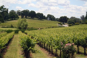
The Shenandoah Valley was once the principal viticultural region of California though not as well known as the Napa Valley AVA or Sonoma Valley AVA viticultural regions.[26] With the discovery of gold, the area quickly became a mecca for those trying to make their fortune. In the process numerous wineries sprouted up, many of whose vineyards are still in use by wineries today. The decline of the California Gold Rush coupled with the onset of Prohibition devastated the wine-making region of Amador County. Today this area has been resurrected and is now home to over 40 different wineries. Amador County is known for its Zinfandel, but many other varietals are produced as well. Amador County has a high percentage of old Zinfandel vines. Some of the Zinfandel vineyards in this county are more than 125 years old[when?], including the original Grandpère vineyard, planted with Zinfandel before 1869 and believed to be the oldest Zinfandel vineyard in America.[27] This 10-acre (40,000 m2) vineyard is home to some of the oldest Zinfandel vines on earth, with proof of their existence dating to 1869 when it was listed as a descriptor on a deed from the U.S. Geological Survey. A grant deed in Amador County records further proves their existence in 1869.[citation needed]
Politics, government, and policing
County Supervisors
The county is governed by a five-person elected Board of Supervisors and a County Administrator. The county seat is Jackson.
Policing
The unincorporated areas of Amador County are patrolled by the county sheriff's department who also operates the county jail and protects the courts. Municipal police departments within the county are at Ione, Jackson, and Sutter Creek.
Voter registration statistics
| Population and registered voters | ||
|---|---|---|
| Total population[16] | 38,244 | |
| Registered voters[28][note 3] | 21,453 | 56.1% |
| Democratic[28] | 6,790 | 31.7% |
| Republican[28] | 9,663 | 45.0% |
| Democratic–Republican spread[28] | -2,873 | -13.3% |
| American Independent[28] | 894 | 4.2% |
| Green[28] | 114 | 0.5% |
| Libertarian[28] | 185 | 0.9% |
| Peace and Freedom[28] | 46 | 0.2% |
| Americans Elect[28] | 0 | 0.0% |
| Other[28] | 78 | 0.4% |
| No party preference[28] | 3,683 | 17.2% |
Cities by population and voter registration
| City | Population[16] | Registered voters[28] [note 3] |
Democratic[28] | Republican[28] | D–R spread[28] | Other[28] | No party preference[28] |
|---|---|---|---|---|---|---|---|
| Amador | 158 | 83.5% | 34.1% | 41.7% | -7.6% | 9.8% | 18.2% |
| Ione | 7,873 | 29.0% | 27.3% | 49.4% | -22.1% | 11.4% | 16.8% |
| Jackson | 4,626 | 55.7% | 32.3% | 42.6% | -10.3% | 11.2% | 18.4% |
| Plymouth | 1,055 | 49.4% | 30.9% | 38.8% | -7.9% | 13.2% | 22.5% |
| Sutter Creek | 2,497 | 68.4% | 35.9% | 41.9% | -6.0% | 9.6% | 16.7% |
Politics
| Year | Republican | Democratic | Third party | |||
|---|---|---|---|---|---|---|
| No. | % | No. | % | No. | % | |
| 2020 | 13,585 | 60.66% | 8,153 | 36.40% | 659 | 2.94% |
| 2016 | 10,485 | 58.37% | 6,004 | 33.42% | 1,474 | 8.21% |
| 2012 | 10,281 | 58.11% | 6,830 | 38.60% | 582 | 3.29% |
| 2008 | 10,561 | 55.94% | 7,813 | 41.38% | 505 | 2.67% |
| 2004 | 11,107 | 62.08% | 6,541 | 36.56% | 243 | 1.36% |
| 2000 | 8,766 | 56.69% | 5,906 | 38.19% | 792 | 5.12% |
| 1996 | 6,870 | 47.54% | 5,868 | 40.60% | 1,714 | 11.86% |
| 1992 | 5,477 | 35.49% | 5,286 | 34.25% | 4,671 | 30.26% |
| 1988 | 6,893 | 55.87% | 5,197 | 42.12% | 248 | 2.01% |
| 1984 | 6,986 | 61.48% | 4,188 | 36.86% | 189 | 1.66% |
| 1980 | 5,401 | 55.85% | 3,191 | 33.00% | 1,078 | 11.15% |
| 1976 | 3,699 | 46.13% | 4,037 | 50.35% | 282 | 3.52% |
| 1972 | 3,533 | 53.40% | 2,705 | 40.89% | 378 | 5.71% |
| 1968 | 2,269 | 42.10% | 2,440 | 45.27% | 681 | 12.63% |
| 1964 | 1,682 | 32.99% | 3,410 | 66.89% | 6 | 0.12% |
| 1960 | 2,175 | 44.51% | 2,690 | 55.04% | 22 | 0.45% |
| 1956 | 2,126 | 49.16% | 2,181 | 50.43% | 18 | 0.42% |
| 1952 | 2,440 | 52.42% | 2,169 | 46.60% | 46 | 0.99% |
| 1948 | 1,578 | 38.84% | 2,334 | 57.45% | 151 | 3.72% |
| 1944 | 1,191 | 37.18% | 1,976 | 61.69% | 36 | 1.12% |
| 1940 | 1,372 | 32.85% | 2,762 | 66.14% | 42 | 1.01% |
| 1936 | 777 | 23.38% | 2,506 | 75.41% | 40 | 1.20% |
| 1932 | 822 | 25.34% | 2,367 | 72.97% | 55 | 1.70% |
| 1928 | 990 | 44.12% | 1,246 | 55.53% | 8 | 0.36% |
| 1924 | 719 | 38.93% | 316 | 17.11% | 812 | 43.96% |
| 1920 | 1,350 | 64.13% | 639 | 30.36% | 116 | 5.51% |
| 1916 | 1,209 | 38.53% | 1,766 | 56.28% | 163 | 5.19% |
| 1912 | 5 | 0.20% | 1,622 | 64.80% | 876 | 35.00% |
| 1908 | 1,035 | 51.88% | 874 | 43.81% | 86 | 4.31% |
| 1904 | 1,279 | 54.45% | 915 | 38.95% | 155 | 6.60% |
| 1900 | 1,384 | 52.64% | 1,209 | 45.99% | 36 | 1.37% |
| 1896 | 1,144 | 44.39% | 1,398 | 54.25% | 35 | 1.36% |
| 1892 | 1,125 | 43.04% | 1,255 | 48.01% | 234 | 8.95% |
| 1888 | 1,373 | 47.48% | 1,429 | 49.41% | 90 | 3.11% |
| 1884 | 1,317 | 47.72% | 1,358 | 49.20% | 85 | 3.08% |
| 1880 | 1,345 | 48.73% | 1,411 | 51.12% | 4 | 0.14% |
Crime
The following table includes the number of incidents reported and the rate per 1,000 persons for each type of offense.
| Population and crime rates | ||
|---|---|---|
| Population[16] | 38,244 | |
| Violent crime[30] | 107 | 2.80 |
| Homicide[30] | 1 | 0.03 |
| Forcible rape[30] | 10 | 0.26 |
| Robbery[30] | 10 | 0.26 |
| Aggravated assault[30] | 86 | 2.25 |
| Property crime[30] | 537 | 14.04 |
| Burglary[30] | 337 | 8.81 |
| Larceny-theft[30][note 4] | 459 | 12.00 |
| Motor vehicle theft[30] | 60 | 1.57 |
| Arson[30] | 2 | 0.05 |
Cities by population and crime rates
| City | Population[31] | Violent crimes[31] | Violent crime rate per 1,000 persons |
Property crimes[31] | Property crime rate per 1,000 persons |
|---|---|---|---|---|---|
| Ione | 7,977 | 10 | 1.25 | 109 | 13.66 |
| Jackson | 4,677 | 38 | 8.12 | 136 | 29.08 |
| Sutter Creek | 2,513 | 7 | 2.79 | 62 | 24.67 |
Education
Due to the low population of the area, there are few schools with small class sizes. In total for public schools, there are two high schools, two junior high schools, and six elementary schools.[32] These numbers are in addition to two independent study schools, one charter school, and one continuing education school for adults. There are no colleges or universities within the county's borders.
In popular culture
"The Luck of Roaring Camp" is a short story by American author Bret Harte. It was first published in the August 1868 issue of the Overland Monthly and helped push Harte to international prominence. Harte lived in this area during his "Gold Rush" period, and possibly based the story in a mining camp on the Mokelumne River.
In the 1993 movie Homeward Bound: The Incredible Journey, a map of Amador County is shown, as well as many other California counties.
Transportation
Major highways
 State Route 16
 State Route 26
 State Route 49
 State Route 88
 State Route 104
 State Route 124
Public transportation
Amador Transit provides service in Jackson and nearby communities. Connections to Calaveras County and Sacramento are additionally provided.
Airport
Amador County Airport is a general aviation airport located near Jackson.
Communities
Cities
- Amador City
- Ione
- Jackson (county seat)
- Plymouth
- Sutter Creek
Unincorporated communities
- Amador Pines[note 5]
- Barton
- Bonnefoy
- Buckhorn[note 5]
- Buena Vista[note 5]
- Camanche North Shore[note 5]
- Camanche Village[note 5]
- Carbondale
- Clinton
- Drytown[note 5]
- Electra
- Enterprise
- Fiddletown[note 5]
- Kirkwood[note 5]
- Kit Carson
- Lockwood[note 5]
- Martell[note 5]
- New Chicago
- Pine Acres
- Pine Grove[note 5]
- Pioneer[note 5]
- Red Corral[note 5]
- River Pines[note 5]
- Roaring Camp
- Scottsville
- Sunnybrook
- Sutter Hill
- Volcano[note 5]
See also
- California State Library – California Room Collection. Amador County Legal Records, 1853–1868.
- List of school districts in Amador County, California
- National Register of Historic Places listings in Amador County, California
- Amador High School
Notes
- Other = Some other race + Two or more races
- Native American = Native Hawaiian or other Pacific Islander + American Indian or Alaska Native
- Percentage of registered voters with respect to total population. Percentages of party members with respect to registered voters follow.
- Only larceny-theft cases involving property over $400 in value are reported as property crimes.
- For statistical purposes, defined by the United States Census Bureau as a census-designated place (CDP).
References
- "Amador County". Geographic Names Information System. United States Geological Survey, United States Department of the Interior. Retrieved February 10, 2015.
- "Board of Supervisors | Amador County".
- "Thunder Mountain". Peakbagger.com. Retrieved February 10, 2015.
- "Amador County, California". United States Census Bureau. Retrieved January 30, 2022.
- "Find a County". National Association of Counties. Archived from the original on May 31, 2011. Retrieved June 7, 2011.
- , Judicial Council of California. Retrieved August 2, 2009.
- Whittle, Syd (September 8, 2008). "1854 · Amador County · 1954". The Historical Marker Database. J. J. Prats. Retrieved May 14, 2012. (historical marker placed by Board of Supervisors and Amador County Historical Society, 1954)
- William Bright; Erwin Gustav Gudde (November 30, 1998). 1500 California place names: their origin and meaning. University of California Press. p. 15. ISBN 978-0-520-21271-8. Retrieved January 20, 2012.
- "2010 Census Gazetteer Files". United States Census Bureau. August 22, 2012. Retrieved September 24, 2015.
- "Census of Population and Housing from 1790-2000". US Census Bureau. Retrieved January 24, 2022.
- "Historical Census Browser". University of Virginia Library. Retrieved September 24, 2015.
- Forstall, Richard L., ed. (March 27, 1995). "Population of Counties by Decennial Census: 1900 to 1990". United States Census Bureau. Retrieved September 24, 2015.
- "Census 2000 PHC-T-4. Ranking Tables for Counties: 1990 and 2000" (PDF). United States Census Bureau. April 2, 2001. Retrieved September 24, 2015.
- "P2 HISPANIC OR LATINO, AND NOT HISPANIC OR LATINO BY RACE - 2010: DEC Redistricting Data (PL 94-171) - Amador County, California". United States Census Bureau.
- "P2 HISPANIC OR LATINO, AND NOT HISPANIC OR LATINO BY RACE - 2020: DEC Redistricting Data (PL 94-171) - Amador County, California". United States Census Bureau.
- U.S. Census Bureau. American Community Survey, 2011 American Community Survey 5-Year Estimates, Table B02001. U.S. Census website. Retrieved October 26, 2013.
- U.S. Census Bureau. American Community Survey, 2011 American Community Survey 5-Year Estimates, Table B03003. U.S. Census website. Retrieved October 26, 2013.
- U.S. Census Bureau. American Community Survey, 2011 American Community Survey 5-Year Estimates, Table B19301. U.S. Census website. Retrieved October 21, 2013.
- U.S. Census Bureau. American Community Survey, 2011 American Community Survey 5-Year Estimates, Table B19013. U.S. Census website. Retrieved October 21, 2013.
- U.S. Census Bureau. American Community Survey, 2011 American Community Survey 5-Year Estimates, Table B19113. U.S. Census website. Retrieved October 21, 2013.
- U.S. Census Bureau. American Community Survey, 2011 American Community Survey 5-Year Estimates. U.S. Census website. Retrieved October 21, 2013.
- U.S. Census Bureau. American Community Survey, 2011 American Community Survey 5-Year Estimates, Table B01003. U.S. Census website. Retrieved October 21, 2013.
- Data unavailable
- "2010 Census P.L. 94-171 Summary File Data". United States Census Bureau.
- "U.S. Census website". United States Census Bureau. Retrieved May 14, 2011.
- Costa, Eric J (January 1, 1994). Old vines: A history of winegrowing in Amador County. Jackson, CA: Cenotto Publications. pp. v, 46. ISBN 0-938121-08-1.
- "Golden Oldies / There's more than just fruit in old-vine Zinfandel – its earthy flavors are history in a bottle – SFGate". SFgate.com. Hearst Communications Inc. July 28, 2005. Retrieved December 14, 2010.
- California Secretary of State. February 10, 2013 – Report of Registration Archived November 3, 2013, at the Wayback Machine. Retrieved October 31, 2013.
- Leip, David. "Dave Leip's Atlas of U.S. Presidential Elections". uselectionatlas.org. Retrieved October 29, 2022.
- Office of the Attorney General, Department of Justice, State of California. Table 11: Crimes – 2009 Archived December 2, 2013, at the Wayback Machine. Retrieved November 14, 2013.
- United States Department of Justice, Federal Bureau of Investigation. Crime in the United States, 2012, Table 8 (California). Retrieved November 14, 2013.
- "Amador County Public Schools". Amadorcoe. Retrieved November 26, 2018.
External links
Places adjacent to Amador County, California | ||||||||||||||||
|---|---|---|---|---|---|---|---|---|---|---|---|---|---|---|---|---|
| ||||||||||||||||
Municipalities and communities of Amador County, California, United States | ||
|---|---|---|
County seat: Jackson | ||
| Cities |  | |
| CDPs | ||
| Other unincorporated communities |
| |
| Ghost towns |
| |
| Footnotes | ‡This CDP also has portions in an adjacent county or counties | |
| ||
State of California | |
|---|---|
Sacramento (capital) | |
| Topics |
|
| Regions |
|
| Metro regions |
|
| Counties |
|
| Most populous cities | |
Authority control | |
|---|---|
| General | |
| National libraries | |
| Other |
|
На других языках
[de] Amador County
Das Amador County[1] ist ein County im US-Bundesstaat Kalifornien. Der Verwaltungssitz (County Seat) ist Jackson. Das County liegt in der Sierra Nevada und ist auch bekannt für seinen Weinanbau (→ siehe die geschützten Herkunftsbezeichnungen California Shenandoah Valley AVA, Fiddletown AVA, Sierra Foothills AVA).- [en] Amador County, California
[ru] Амадор (округ)
А́мадор[1] (англ. Amador) — округ штата Калифорния, расположенный в горах Сьерра-Невада. По данным[2] переписи 2000 года, население Амадора составляет 35 100 человек. Окружной центр — город Джексон.Другой контент может иметь иную лицензию. Перед использованием материалов сайта WikiSort.org внимательно изучите правила лицензирования конкретных элементов наполнения сайта.
WikiSort.org - проект по пересортировке и дополнению контента Википедии