world.wikisort.org - USA
Colorado Springs is a home rule municipality in, and the county seat of El Paso County, Colorado, United States.[1] It is the largest city in El Paso County, with a population of 478,961 at the 2020 United States Census, a 15.02% increase since 2010.[7][9] Colorado Springs is the second-most populous city and the most extensive city in the state of Colorado, and the 40th-most populous city in the United States.[10] It is the principal city of the Colorado Springs, CO Metropolitan Statistical Area and the second-most prominent city of the Front Range Urban Corridor. It is located in east-central Colorado, on Fountain Creek, 70 miles (113 km) south of Denver.
Colorado Springs, Colorado | |
|---|---|
Home rule municipality[1] | |
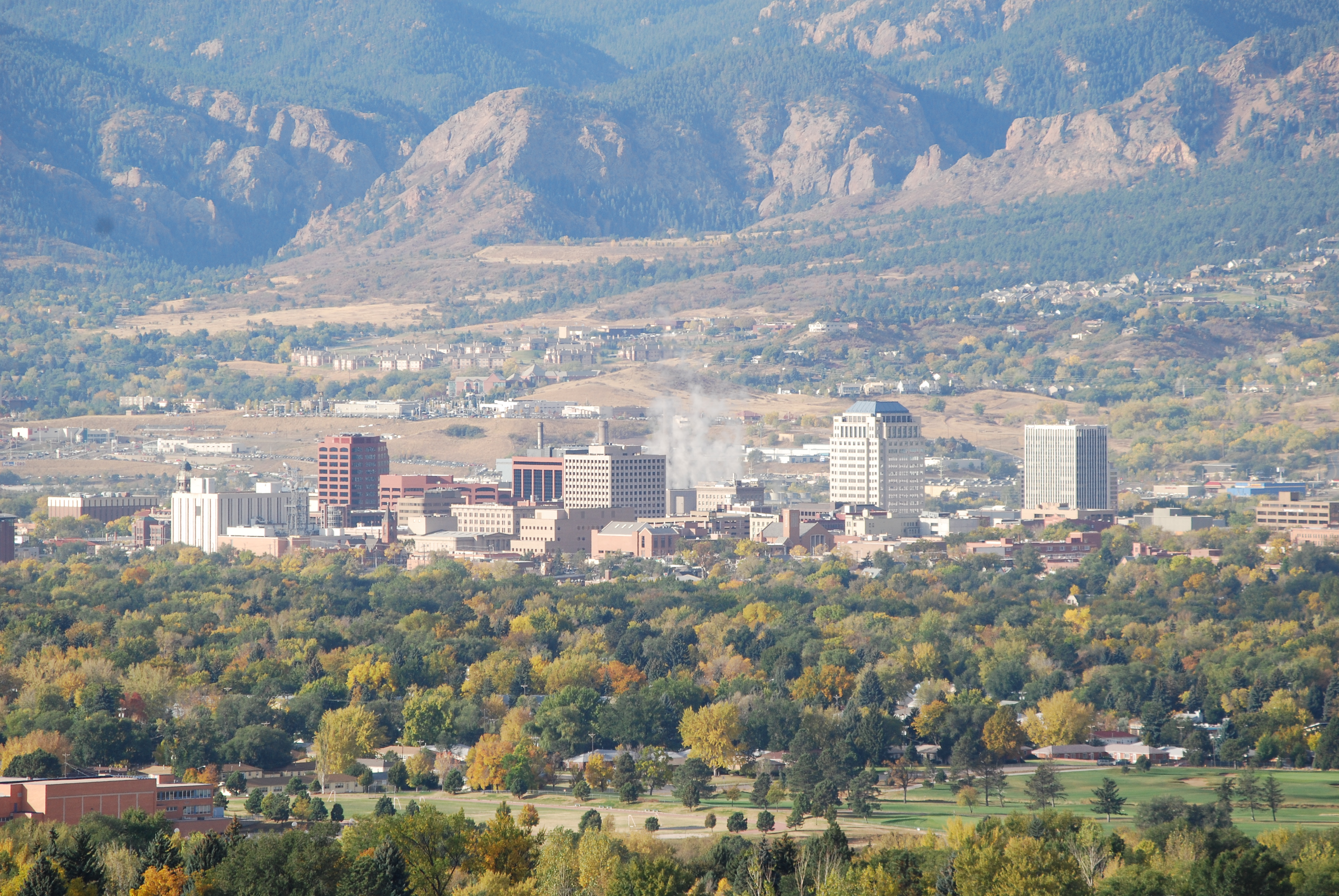 Colorado Springs with the Front Range in the background | |
 Flag | |
| Nicknames: | |
 Location of the City of Colorado Springs in El Paso County, Colorado | |
 Colorado Springs Location of the City of Colorado Springs in the United States | |
| Coordinates: 38°50′02″N 104°49′31″W | |
| Country | |
| State | |
| County | El Paso County seat[5] |
| Incorporated | June 19, 1886[6] |
| Government | |
| • Type | Home rule municipality[1] |
| • Mayor | John Suthers (R)[lower-alpha 1] |
| Area | |
| • Total | 195.761 sq mi (507.019 km2) |
| • Land | 195.399 sq mi (506.082 km2) |
| • Water | 0.362 sq mi (0.937 km2) |
| Population (2020)[7] | |
| • Total | |
| • Rank | 2nd in Colorado 40th in the United States |
| • Metro | 755,105 (79th) |
| • Front Range | 5,055,344 |
| Time zone | UTC−07:00 (MST) |
| • Summer (DST) | UTC–06:00 (MDT) |
| ZIP codes[8] | 80901–80951, 80960, 80962, 80970, 80977, 80995, 80997 |
| Area code | 719 |
| FIPS code | 08-16000 |
| GNIS feature ID | 0204797 |
| Website | coloradosprings |
At 6,035 feet (1,839 m) the city stands over 1 mile (1.6 km) above sea level, though some areas are significantly higher and lower. Colorado Springs is near the base of Pikes Peak, which rises 14,115 feet (4,302.31 m) above sea level on the eastern edge of the Southern Rocky Mountains.
History
The Ute, Arapaho and Cheyenne peoples were the first recorded inhabiting the area which would become Colorado Springs.[11] Part of the territory included in the United States' 1803 Louisiana Purchase, the current city area was designated part of the 1854 Kansas Territory. In 1859, after the first local settlement was established, it became part of the Jefferson Territory on October 24 and of El Paso County on November 28. Colorado City at the Front Range confluence of Fountain and Camp creeks was "formally organized on August 13, 1859"[12] during the Pikes Peak Gold Rush. It served as the capital of the Colorado Territory from November 5, 1861, until August 14, 1862, when the capital was moved to Golden, before it was finally moved to Denver in 1867.[13] So many immigrants from England had settled in Colorado Springs by the early 1870s that Colorado Springs was locally referred to as "Little London."[14] In 1871 the Colorado Springs Company laid out the towns of La Font (later called Manitou Springs) and Fountain Colony, upstream and downstream respectively, of Colorado City.[15] Within a year, Fountain Colony was renamed Colorado Springs and officially incorporated.[16] The El Paso County seat shifted from Colorado City in 1873 to the Town of Colorado Springs.[17] On December 1, 1880, Colorado Springs expanded northward with two annexations.[18][19]
| People |
|---|
|
| Coal mining areas |
|
| Other mining topics |
|
The second period of annexations was during 1889–90, and included Seavey's Addition, West Colorado Springs, East End, and another North End addition.[18] In 1891 the Broadmoor Land Company built the Broadmoor suburb, which included the Broadmoor Casino, and by December 12, 1895, the city had "four Mining Exchanges and 275 mining brokers."[20] By 1898, the city was designated into quadrants by the north-south Cascade Avenue and the east-west Washington/Pikes Peak avenues.[19]: 10
From 1899 to 1901 Tesla Experimental Station operated on Knob Hill,[21] and aircraft flights to the Broadmoor's neighboring fields began in 1919.[22] Alexander Airport north of the city opened in 1925, and in 1927 the original Colorado Springs Municipal Airport land was purchased east of the city.[22]
The city's military presence began during World War II, beginning with Camp Carson (now the 135,000-acre Fort Carson base) that was established in 1941.[23] During the war, the United States Army Air Forces leased land adjacent to the municipal airfield, naming it Peterson Field in December 1942.[24][25]
In November 1950, Ent Air Force Base was selected as the Cold War headquarters for Air Defense Command (ADC). The former WWII Army Air Base, Peterson Field, which had been inactivated at the end of the war, was re-opened in 1951 as a U.S. Air Force base.[26] North American Aerospace Defense Command (NORAD) was established as a hardened command and control center within the Cheyenne Mountain Complex during the Cold War.[27]
Between 1965 and 1968, the University of Colorado Colorado Springs, Pikes Peak State College and Colorado Technical University were established in or near the city.[28][29] In 1977 most of the former Ent AFB became a US Olympic training center. The Libertarian Party was founded within the city in the 1970s.[30]
On October 1, 1981, the Broadmoor Addition,[18] Cheyenne Canon, Ivywild, Skyway, and Stratton Meadows were annexed after the Colorado Supreme Court "overturned a district court decision that voided the annexation". Further annexations expanding the city include the Nielson Addition and Vineyard Commerce Park Annexation in September 2008.[18]
Geography
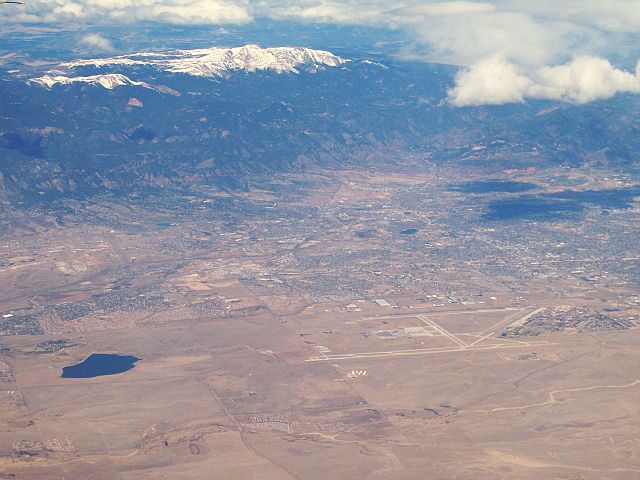
The city lies in a semi-arid Steppe climate region[31] with the Southern Rocky Mountains to the west, the Palmer Divide to the north, high plains further east, and high desert lands to the south when leaving Fountain and approaching Pueblo.[32] Colorado Springs is 69 miles (111 km) or one hour and five minutes south of Denver by car using I-25.[33]
Colorado Springs has the greatest total area of any municipality in Colorado. At the 2020 United States Census, the city had a total area of 125,287 acres (507.019 km2) including 232 acres (0.937 km2) of water.[7]
Metropolitan area
Colorado Springs has many features of a modern urban area such as parks, bike trails, and open spaces. However, it is not exempt from problems that typically plague cities experiencing tremendous growth such as overcrowded roads and highways, crime, sprawl, and government budgetary issues. Many of the problems are indirectly or directly caused by the city's difficulty in coping with the large population growth experienced since 1997, and the annexation of the Banning Lewis Ranch area to accommodate further population growth of 175,000 future residents.[34]
Climate

Colorado Springs has a cooler, dry-winter semi-arid climate (Köppen BSk), and its location just east of the Rocky Mountains affords it the rapid warming influence from chinook winds during winter but also subjects it to drastic day-to-day variability in weather conditions.[35] The city has abundant sunshine year-round, averaging 243 sunny days per year,[36][37] and receives approximately 16.5 inches (419 mm) of annual precipitation. Due to unusually low precipitation for several years after flooding in 1999, Colorado Springs enacted lawn water restrictions in 2002. These were lifted in 2005[32] but permanently reinstated in December 2019.[38]
Colorado Springs is one of the most active lightning strike areas in the United States.[31] This natural phenomenon led Nikola Tesla to select Colorado Springs as the preferred location to build his lab and study electricity.[39]
Seasonal climate

Winters range from mild to moderately cold, with December, the coldest month, averaging 30.8 °F (−0.7 °C); historically January has been the coldest month, but, in recent years, December has had both lower daily maxima and minima.[40] Typically, there are 5.2 nights with sub-0 °F (−18 °C) lows and 23.6 days where the high does not rise above freezing.[41]
Snowfall is usually moderate and remains on the ground briefly because of direct sun, with the city receiving 38 inches (97 cm) per season, although the mountains to the west often receive in excess of triple that amount; March is the snowiest month in the region, both by total accumulation and number of days with measurable snowfall. In addition, 8 of the top 10 heaviest 24-hour snowfalls have occurred from March to May.[41] Summers are warm, with July, the warmest month, averaging 70.9 °F (21.6 °C), and 18 days of 90 °F (32 °C)+ highs annually. Due to the high elevation and aridity, nights are usually relatively cool and rarely does the low remain above 70 °F (21 °C).[41] Dry weather generally prevails, but brief afternoon thunderstorms are common, especially in July and August when the city receives the majority of its annual rainfall, due to the North American monsoon.[42]
The first autumn freeze and the last freeze in the spring, on average, occur on October 2 and May 6, respectively; the average window for measurable snowfall (≥0.1 in or 0.25 cm) is October 21 through April 25. Extreme temperatures range from 101 °F (38 °C) on June 26, 2012 and most recently on June 21, 2016, down to −27 °F (−33 °C) on February 1, 1951, and December 9, 1919.[43]
Climate data
| Climate data for Colorado Springs, Colorado (Airport), 1991–2020 normals,[lower-alpha 2] extremes 1894–present | |||||||||||||
|---|---|---|---|---|---|---|---|---|---|---|---|---|---|
| Month | Jan | Feb | Mar | Apr | May | Jun | Jul | Aug | Sep | Oct | Nov | Dec | Year |
| Record high °F (°C) | 73 (23) |
77 (25) |
81 (27) |
87 (31) |
94 (34) |
101 (38) |
100 (38) |
99 (37) |
98 (37) |
87 (31) |
78 (26) |
77 (25) |
101 (38) |
| Mean maximum °F (°C) | 64.5 (18.1) |
66.2 (19.0) |
72.8 (22.7) |
79.0 (26.1) |
85.8 (29.9) |
93.8 (34.3) |
95.2 (35.1) |
92.7 (33.7) |
88.9 (31.6) |
81.8 (27.7) |
71.6 (22.0) |
64.1 (17.8) |
96.7 (35.9) |
| Average high °F (°C) | 45.0 (7.2) |
46.5 (8.1) |
54.9 (12.7) |
61.0 (16.1) |
70.7 (21.5) |
81.6 (27.6) |
86.5 (30.3) |
83.6 (28.7) |
77.1 (25.1) |
64.7 (18.2) |
52.9 (11.6) |
44.6 (7.0) |
64.1 (17.8) |
| Daily mean °F (°C) | 31.8 (−0.1) |
33.4 (0.8) |
41.1 (5.1) |
47.5 (8.6) |
57.5 (14.2) |
67.2 (19.6) |
72.4 (22.4) |
70.1 (21.2) |
63.0 (17.2) |
50.7 (10.4) |
39.5 (4.2) |
31.7 (−0.2) |
50.5 (10.3) |
| Average low °F (°C) | 18.5 (−7.5) |
20.2 (−6.6) |
27.3 (−2.6) |
34.0 (1.1) |
43.5 (6.4) |
52.8 (11.6) |
58.2 (14.6) |
56.6 (13.7) |
48.9 (9.4) |
36.6 (2.6) |
26.0 (−3.3) |
18.7 (−7.4) |
36.8 (2.7) |
| Mean minimum °F (°C) | −1.4 (−18.6) |
1.4 (−17.0) |
9.6 (−12.4) |
19.3 (−7.1) |
30.1 (−1.1) |
42.5 (5.8) |
50.9 (10.5) |
48.5 (9.2) |
35.6 (2.0) |
19.6 (−6.9) |
7.4 (−13.7) |
−1.6 (−18.7) |
−7.1 (−21.7) |
| Record low °F (°C) | −26 (−32) |
−27 (−33) |
−16 (−27) |
−3 (−19) |
15 (−9) |
27 (−3) |
37 (3) |
34 (1) |
20 (−7) |
−6 (−21) |
−12 (−24) |
−27 (−33) |
−27 (−33) |
| Average precipitation inches (mm) | 0.29 (7.4) |
0.32 (8.1) |
0.79 (20) |
1.45 (37) |
1.99 (51) |
2.27 (58) |
3.12 (79) |
2.96 (75) |
1.35 (34) |
0.77 (20) |
0.37 (9.4) |
0.23 (5.8) |
15.91 (404) |
| Average snowfall inches (cm) | 4.9 (12) |
4.6 (12) |
5.7 (14) |
5.5 (14) |
0.6 (1.5) |
0 (0) |
0 (0) |
0 (0) |
0.2 (0.51) |
2.5 (6.4) |
4.4 (11) |
4.1 (10) |
32.5 (83) |
| Average precipitation days (≥ 0.01 in) | 3.6 | 4.6 | 6.7 | 8.2 | 10.3 | 9.8 | 12.1 | 12.4 | 6.6 | 4.8 | 4.5 | 3.7 | 87.3 |
| Average snowy days (≥ 0.1 in) | 3.9 | 4.4 | 4.9 | 3.6 | 0.6 | 0 | 0 | 0 | 0.3 | 1.7 | 3.7 | 4.0 | 27.1 |
| Mean monthly sunshine hours | 217 | 224 | 279 | 300 | 310 | 330 | 341 | 310 | 270 | 248 | 210 | 217 | 3,256 |
| Source 1: NOAA[41][44][45] | |||||||||||||
| Source 2: Weather-US[46][47][48] | |||||||||||||
Cityscape

Demographics
| Historical population | |||
|---|---|---|---|
| Census | Pop. | %± | |
| 1880 | 4,226 | — | |
| 1890 | 11,140 | 163.6% | |
| 1900 | 21,085 | 89.3% | |
| 1910 | 29,078 | 37.9% | |
| 1920 | 30,105 | 3.5% | |
| 1930 | 33,237 | 10.4% | |
| 1940 | 36,789 | 10.7% | |
| 1950 | 45,472 | 23.6% | |
| 1960 | 70,194 | 54.4% | |
| 1970 | 135,517 | 93.1% | |
| 1980 | 215,105 | 58.7% | |
| 1990 | 281,140 | 30.7% | |
| 2000 | 360,890 | 28.4% | |
| 2010 | 416,427 | 15.4% | |
| 2020 | 478,961 | 15.0% | |
| U.S. Decennial Census | |||

As of the 2020 United States Census, the population of the City of Colorado Springs was 478,961 (40th most populous U.S. city), the population of the Colorado Springs Metropolitan Statistical Area was 755,105 (79th most populous MSA), and the population of the Front Range Urban Corridor was 5,055,344.[7]
As of the April 2010 census,[49] 78.8% of the population of the city was White (non-Hispanic Whites were 70.7% of the population,[50] compared with 86.6% in 1970[51]), 16.1% Hispanic or Latino of any race (compared with 7.4% in 1970), 6.3% Black or African American, 3.0% Asian, 1.0% descended from indigenous peoples of the Americas, 0.3% descended from indigenous Hawaiians and other Pacific islanders, 5.5% of some other race, and 5.1% of two or more races. Mexican Americans made up 14.6% of the city's population, compared with 9.1% in 1990. The median age in the city was 35 years.[52][nb 1]
Economy
Colorado Springs's economy is driven primarily by the military, the high-tech industry, and tourism, in that order. The city is experiencing growth in the service sectors. Its unemployment rate as of June 2022 was 3.5%, a decrease from 6.5% in June 2021. In June 2019, before the COVID-19 pandemic, the unemployment rate was 3.3%.[54] The state's unemployment rate in June 2022 was 3.4%[55] compared to 3.6% for the nation.[56]
Military
As of 2021[update], there are nearly 45,000 active-duty troops in Colorado Springs. There are more than 100,000 veterans and thousands of reservists.[23] The military and defense contractors supply more than 40% of the Pikes Peak region's economy.[23]
Colorado Springs is home to the Peterson Space Force Base, Schriever Space Force Base, Cheyenne Mountain Space Force Station, U.S. Space Command, and Space Operations Command— the largest contingent of space service military installations. They are responsible for intelligence gathering, space operations, and cyber missions.[57]
Peterson Space Force Base is responsible for the North American Aerospace Defense Command (NORAD) and the United States Northern Command (USNORTHCOM) headquarters,[27] Space Operations Command, and Space Deltas 2, 3, and 7.[57] Located at Peterson is the 302nd Airlift Wing, an Air Force Reserve unit, that transports passengers and cargo and fights wildfires.[57]
Schriever Space Force Base is responsible for Joint Task Force-Space Defense and Space Deltas 6, 8, and 9.[57] The NORAD and USNORTHCOM Alternate Command Center is located at the Cheyenne Mountain Complex.[27] Within the mountain complex, the Cheyenne Mountain Space Force Station has been operated by Space Operations Command.[27] On January 13, 2021, the Air Force announced a new permanent home for Space Command, moving it from Colorado Springs to Huntsville, Alabama in 2026, but the decision could be reversed by Congress.[23][58][lower-alpha 3]

Army divisions are trained and stationed at Fort Carson. The United States Air Force Academy was established after World War II, on land donated by the City of Colorado Springs.[23]
Defense industry
The defense industry forms a significant part of the Colorado Springs economy, with some of the city's largest employers being defense contractors.[62] Some defense corporations have left or downsized city campuses, but slight growth has been recorded. Significant defense corporations in the city include Northrop Grumman, Boeing, General Dynamics, L3Harris Technologies, SAIC, ITT, Lockheed Martin, and Bluestaq.[63][64][65][66] The Space Foundation is based in Colorado Springs.[67]
High-tech industry
A large percentage of Colorado Springs's economy is still based on manufacturing high-tech and complex electronic equipment. The high-tech sector in the Colorado Springs area has decreased its overall presence from 2000 to 2006 (from around 21,000 to around 8,000), with notable reductions in information technology and complex electronic equipment.[68] Current trends project the high-tech employment ratio will continue to decrease.[69][70][71][72][needs update]
High-tech corporations with connections to the city include: Verizon Business, a telecommunications firm, at its height had nearly 1300 employees in 2008.[73] Hewlett-Packard still has some sales, support, and SAN storage engineering center for the computer industry.[74][75][76] Storage Networking Industry Association is the home of the SNIA Technology Center.[77] Keysight Technologies, spun off in 2014 from Agilent,[78] which was itself spun off from HP in 1999 as an independent, publicly traded company,[79] has its oscilloscope research and development division based in Colorado Springs. Intel had 250 employees in 2009.[80] The Intel facility is now used for the centralized unemployment offices, social services, El Paso county offices, and a bitcoin mining facility.[81] Microchip Technology (formerly Atmel), is a chip fabrication organization.[82] The Apple Inc. facility was sold to Sanmina-SCI in 1996.[83]
Culture and contemporary life
Tourism

Almost immediately following the arrival of railroads beginning in 1871, the city's location at the base of Pikes Peak and the Rocky Mountains made it a popular tourism destination. Tourism is the third largest employer in the Pikes Peak region, accounting for more than 16,000 jobs.[84] In 2018, 23 million day and overnight visitors came to the area, contributing $2.4 billion in revenue.[85]
Colorado Springs has more than 55 attractions and activities in the area,[86] including Garden of the Gods park, United States Air Force Academy, the ANA Money Museum, Cheyenne Mountain Zoo, Colorado Springs Fine Arts Center at Colorado College, Old Colorado City, The National Museum of World War II Aviation, and the U.S. Olympic & Paralympic Training Center.[87] In 2020, the U.S. Olympic & Paralympic Museum opened;[88] the Flying W Ranch Chuckwagon Dinner & Western Show reopened in 2020.[89] A new Pikes Peak Summit Complex opened at the 14,115-foot summit in 2021.[90] The Manitou and Pikes Peak Railway also reopened in 2021.[91]
The downtown Colorado Springs Visitor Information Center offers free area information to leisure and business travelers.[86] The Cultural Office of the Pikes Peak Region (COPPeR), also downtown, supports and advocates for the arts throughout the Pikes Peak Region. It operates the PeakRadar website to communicate city events.[92]
Annual cultural events
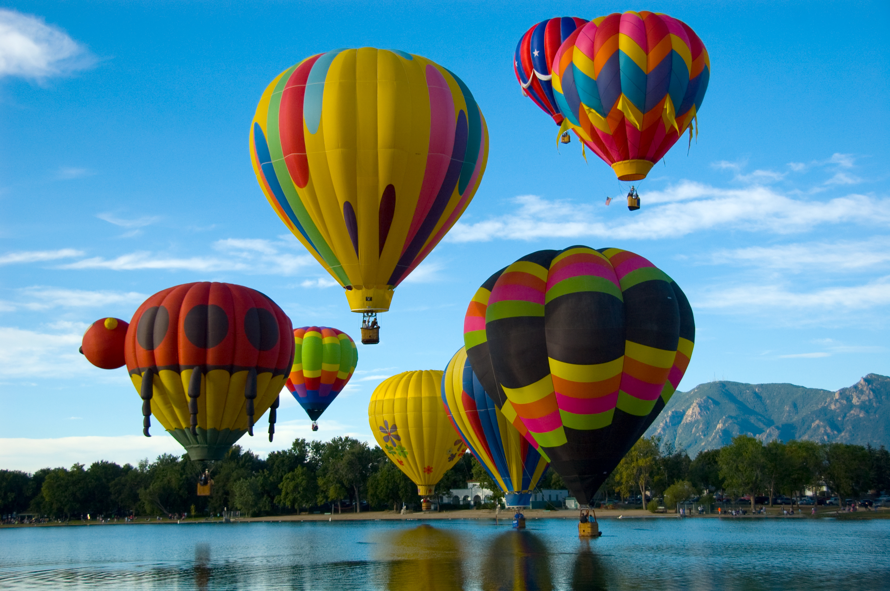
Colorado Springs is home to the annual Colorado Springs Labor Day Lift Off, a hot air balloon festival that takes place over Labor Day weekend at the city's Memorial Park.[93]
Other annual events include: a comic book convention and science fiction convention called GalaxyFest in February,[94] a pride parade called PrideFest in July,[95] the Greek Festival, the Pikes Peak Ascent and Marathon, and the Steers & Beers Whiskey and Beer Festival in August,[96][97][98] and the Emma Crawford Coffin Races and Festival in nearby Manitou Springs and Arts Month in October.[99][100]
The Colorado Springs Festival of Lights Parade is held the first Saturday in December.[101] The parade is held on Tejon Street in Downtown Colorado Springs.[102]
Breweries
In 2017, Colorado had the third-most craft breweries at 348.[103] Breweries and microbreweries have become popular in Colorado Springs, which hosts over 30 of them.[104][105]
Religious institutions
Although houses of worship of almost every major world religion are within the city, Colorado Springs has in particular attracted a large influx of Evangelical Christians and Christian organizations in recent years. At one time Colorado Springs was the national headquarters for 81 different religious organizations, earning the city the tongue-in-cheek nicknames "the Evangelical Vatican"[106] and "The Christian Mecca."
Religious groups with regional or international headquarters in Colorado Springs include:
- Association of Christian Schools International[107]
- Biblica[108]
- Children's HopeChest[109]
- Community Bible Study[110]
- Compassion International[111]
- David C. Cook/Integrity Music[112]
- Development Associates International[113]
- Engineering Ministries International[114]
- Family Talk[115]
- Focus on the Family[116]
- Global Action[117]
- HCJB[118]
- Hope & Home[119]
- The Navigators[120]
- One Child Matters[121]
- Roman Catholic Diocese of Colorado Springs[122]
- VisionTrust[123]
- WAY-FM Media Group[124]
- Young Life[125]
Marijuana
Although Colorado voters approved Colorado Amendment 64, a constitutional amendment in 2012 legalizing retail sales of marijuana for recreational purposes, the Colorado Springs city council voted not to permit retail shops in the city, as was allowed in the amendment.[126] Medical marijuana outlets continue to operate in Colorado Springs.[127] In 2015, there were 91 medical marijuana clinics in the city, which reported sales of $59.6 million in 2014, up 11 percent from the previous year but without recreational marijuana shops.[128] On April 26, 2016, Colorado Springs city council decided to extend the current six-month moratorium to eighteen months with no new licenses to be granted until May 2017. A scholarly paper suggested the city will give up $25.4 million in tax revenue and fees if the city continues to thwart the industry from opening within the city limits.[129][130] As of March 1, 2018, there were 131 medical marijuana centers and no recreational cannabis stores.[131] As of 2019 Colorado Springs is still one of seven towns that have only allowed for medical marijuana.[132]
In popular culture
Colorado Springs has been the subject of or setting for many books, movies and television shows, and is a frequent backdrop for political thrillers and military-themed stories because of its many military installations and vital importance to the United States' continental defense. Notable television series using the city as a setting include Dr. Quinn, Medicine Woman, Homicide Hunter and the Stargate series Stargate SG-1, as well as the films WarGames, The Prestige, and BlacKkKlansman.[133]
In a North Korean propaganda video released in April 2013, Colorado Springs was inexplicably singled out as one of four targets for a missile strike. The video failed to pinpoint Colorado Springs on the map, instead showing a spot somewhere in Louisiana.[134]
Sports
Olympic sports
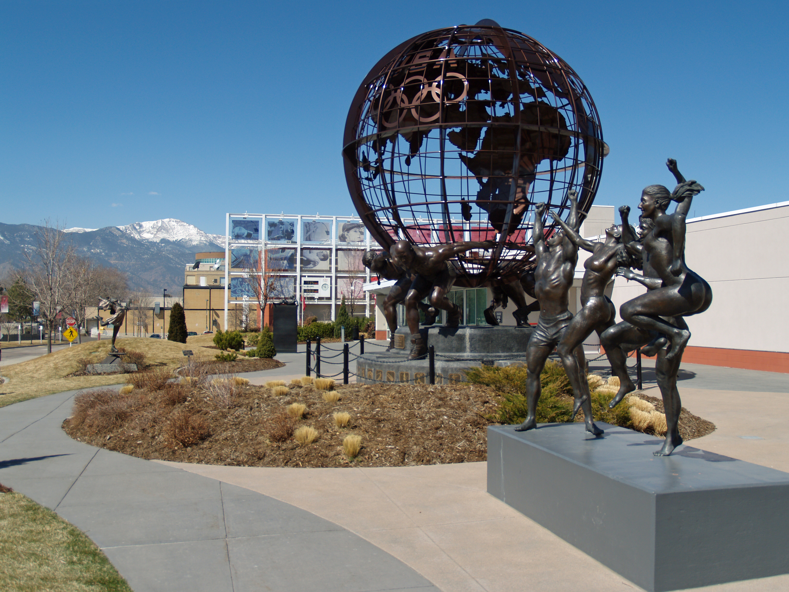
Colorado Springs, dubbed Olympic City USA, is home to the United States Olympic Training Center and the headquarters of the United States Olympic Committee and the United States Anti-Doping Agency.[135]
Further, over 50 national sports organizations (non-Olympic) headquarter in Colorado Springs. These include the National Strength and Conditioning Association, Sports Incubator, a various non-Olympic Sports (such as USA Ultimate), and more.[136]
Colorado Springs and Denver hosted the 1962 World Ice Hockey Championships.[nb 2]
The city has a long association with the sport of figure skating, having hosted the U.S. Figure Skating Championships six times and the World Figure Skating Championships five times. It is home to the World Figure Skating Museum and Hall of Fame and the Broadmoor Skating Club, a notable training center for the sport. In recent years, the Broadmoor World Arena has hosted skating events such as Skate America and the Four Continents Figure Skating Championships.[137]
Baseball
The Colorado Springs Snow Sox professional baseball team is based in Colorado Springs. The team is a member of the Pecos League, an independent baseball league which is not affiliated with Major or Minor League Baseball.[138][139]
Pikes Peak International Hill Climb
The Pikes Peak International Hill Climb (PPIHC), also known as The Race to the Clouds, is an annual invitational automobile and motorcycle hill climb to the summit of Pikes Peak, every year on the last Sunday of June.[140] The highway wasn't completely paved until 2011.[141]
Local professional teams
| Name | Sport | Founded | League | Venue | Ref |
|---|---|---|---|---|---|
| Colorado Springs Switchbacks FC | Soccer | 2015 | USL Championship | Weidner Field | [142] |
| Rocky Mountain Vibes | Baseball | 2019 | Pioneer League | UCHealth Park | [143] |
Local collegiate teams
The local colleges feature many sports teams. Notable among them are several nationally competitive NCAA Division I teams: United States Air Force Academy (Falcons) Football, Basketball and Hockey[144] and Colorado College (Tigers) Hockey, and Women's Soccer.[145]
Rodeo
Colorado Springs was the original headquarters of the Professional Bull Riders (PBR) from its founding in 1992 until 2005, when the organization was moved to Pueblo.[146]
Parks, trails and open space
The city's Parks, Recreation and Cultural Services manage 136 neighborhood parks, eight community parks, seven regional parks, and five sports complexes, totaling 9,000 acres (3,600 ha). They also manage 500 acres (200 ha) of trails, of which 160 miles (260 km) are park trails and 105 miles (169 km) are urban. There are 5,000 acres (2,000 ha) of open space in 48 open-space areas.[147]
Parks
![Ackerman Overlook, near United States Air Force Academy off Interstate 25 in Colorado Springs, is named for Jasper D. Ackerman (1896–1988), a banker and rancher.[148]](http://upload.wikimedia.org/wikipedia/commons/e/ef/Ackerman_Overlook%2C_Colo_Spgs.%2C_CO_IMG_5631.JPG)

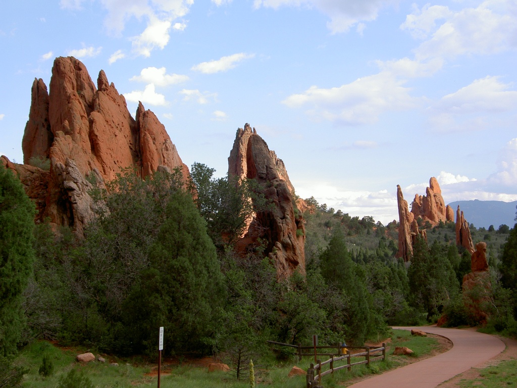
Garden of the Gods is on Colorado Springs's western edge. It is a National Natural Landmark, with 300 foot (91 m) red/orange sandstone rock formations often viewed against a backdrop of the snow-capped Pikes Peak. This park is free to the public and offers many recreational opportunities, such as hiking, rock climbing, cycling, horseback riding and tours.[149] It offers a variety of annual events, one of the most popular of which is the Starlight Spectacular, a recreational bike ride held every summer to benefit the Trails and Open Space Coalition of Colorado Springs.[150]
Colorado Springs has several major city parks, such as Palmer Park, America the Beautiful Park in downtown Colorado Springs, Memorial Park, which includes many sports fields, an indoor swimming pool and skating rink, a skateboard bowl and two half-pipes, and Monument Valley Park, which has walking and biking paths, an outdoor swimming pool and pickleball courts.[151] Monument Valley Park also has Tahama Spring, the original spring in Colorado Springs.[152][153] Austin Bluffs Park affords a place of recreation in eastern Colorado Springs. El Paso County Regional Parks include Bear Creek Regional Park, Bear Creek Dog Park, Fox Run Regional Park and Fountain Creek Regional Park and Nature Center.[154] Ponderosa pine (Pinus ponderosa),[155][156] Gambel oak (Quercus gambelii),[157][158] narrowleaf yucca (Yucca angustissima, syn. Yucca glauca)[159] and prickly pear cactus (Opuntia macrorhiza).[160]
Trails
Three trails, the New Santa Fe Regional Trail, Pikes Peak Greenway and Fountain Creek Regional Trail, form a continuous path from Palmer Lake, through Colorado Springs, to Fountain, Colorado. The majority of the trail between Palmer Lake and Fountain is a soft surface breeze gravel trail. A major segment of the trail within the Colorado Springs city limits is paved. The trails, except Monument Valley Park trails, may be used for equestrian traffic. Motorized vehicles are not allowed on the trails. Many of the trails are interconnected, having main spine trails, like the Pikes Peak Greenway, that lead to secondary trails.[161][162][163]
Government

On November 2, 2010, Colorado Springs voters adopted a council-strong mayor form of government. The City of Colorado Springs transitioned to the new system of government in 2011. Under the council-strong mayor system of government, the mayor is the chief executive and the city council is the legislative branch. The mayor is a full-time elected position and not a member of the council. The council has nine members, six of whom represent one of six equally populated districts each. The remaining three members are elected at-large.[164]
Colorado Springs City Hall was built from 1902 to 1904 on land donated by W. S. Stratton.[165]
City Council
The Colorado Springs City Council consists of nine elected officials, six of whom represent districts and three of whom represent the city at-large.[166]
- District 1 – Dave Donelson
- District 2 – Randy Helms – Council President Pro-Tem
- District 3 – Stephannie Fortune
- District 4 – Yolanda Avila
- District 5 – Nancy Henjum
- District 6 – Mike O'Malley
- At-Large – Bill Murray
- At-Large – Tom Strand – Council President
- At-Large – Wayne Williams
Politics
In 2017 Caleb Hannan wrote in Politico that Colorado Springs was "staunchly Republican", "a right-wing counterweight to liberal Boulder", and that a study ranked it "the fourth most conservative city in America".[167] In the 2016 presidential election, Donald Trump's margin of victory in El Paso County was 22 points. That year Hannan wrote that downtown Colorado Springs had a different political vibe from the overall area's and that there were "superficial signs of changing demographics".[167] In 2020 the shift toward the political center continued as the incumbent Republican, Donald Trump, edged out Democrat Joe Biden by only 10.8% in El Paso County [168]
Education
Primary and secondary education
|
Public schools The public education in the city is divided into several school districts:
|
Private schools
|
In addition the state of Colorado runs the Colorado School for the Deaf and Blind, a residential school for people up to age 21 and established in 1874, in the city.[179]
Higher education

State institutions offering bachelors and graduate degree programs in Colorado Springs include University of Colorado Colorado Springs (UCCS) with more than 12,000 students,[180] and, Pikes Peak State College which offers mostly two-year degree associate degrees.[181] The United States Air Force Academy is a federal institution offering bachelor degrees for officer candidates.[182]
Private non-profit institutions include Colorado College established in 1874 with about 2,000 undergraduates.[183] Colorado Christian University has its Colorado Springs Center in the city.[184]
Private for-profit institutions include Colorado Technical University whose main campus is in Colorado Springs and IntelliTec College a technical training school.
Transportation
Major highways and roads
Interstate highways
Colorado Springs is primarily served by one interstate highway. I-25 runs north and south through Colorado, and traverses the city for nearly 18 miles (29 km), entering the city south of Circle Drive and exiting north of North Gate Boulevard. In El Paso County it is known as Ronald Reagan Highway.[nb 3]
State and U.S. highways
A number of state and U.S. highways serve the city. State Highway 21 is a major east side semi-expressway from Black Forest to Fountain, known locally and co-signed as Powers Boulevard. State Highway 83 runs north–south from central Denver to northern Colorado Springs. State Highway 94 runs east–west from western Cheyenne County to eastern Colorado Springs where it terminates at US 24. US 24 is a major route through the city and county, providing access to Woodland Park via Ute Pass to the west and downtown, Nob Hill and numerous suburbs to the east. It is co-signed with Platte Ave after SH 21 and originally carried local traffic through town. The Martin Luther King Jr Bypass runs from I-25 near Circle Drive along Fountain Blvd to SH 21, then east again. State Highway 115 begins in Cañon City, traveling north along the western edge of Fort Carson; when it reaches the city limits it merges with Nevada Avenue, a signed Business Route of US 85. US 85 and SH 115 are concurrent between Lake Avenue and I-25. US 85 enters the city at Fountain and was signed at Venetucci Blvd, Lake Avenue, and Nevada Avenue[nb 4] at various points in history; however most of US 85 is concurrent with I-25 and is not signed.
County and city roads
In November 2015, voters in Colorado Springs overwhelmingly passed ballot measure 2C, dedicating funds from a temporary sales tax increase to much needed road and infrastructure improvements over five years. This temporary increase is estimated to bring in approximately $50 million annually, which will be used solely to improve roads and infrastructure. The ballot measure passed by a margin of approximately 65–35%.[189]
In 2004, the voters of Colorado Springs and El Paso County established the Pikes Peak Rural Transportation Authority.[190]
In early 2010, the city of Colorado Springs approved an expansion of the northernmost part of Powers Boulevard in order to create an Interstate 25 bypass commonly referred to as the Copper Ridge Expansion.[191][nb 5]
Airport
Colorado Springs Airport (COS; ICAO: KCOS) has been in operation since 1925. It is the second-largest commercial airport in the state, after Denver International Airport (DEN; ICAO: KDEN). It covers 7,200 acres (2,900 ha) of land at an elevation of approximately 6,200 feet (1,900 m). COS is considered to be a joint-use civilian and military airport, as Peterson Space Force Base is a tenant of the airport.[193] It has three paved runways: 17L/35R is 13,501 by 150 feet (4,115 by 46 m), the runway 17R/35L is 11,022 by 150 feet (3,360 by 46 m) and the runway 13/31 is 8,270 by 150 feet (2,521 by 46 m).[194] The airport handled 817,000 passengers from October 2020–October 2021,[195] and is served by American, Delta, Frontier, Southwest, and United.[196]
Bicycling

In April 2018, the Colorado Springs City Council approved a Bike Master Plan.[197] The vision of the city's Bike Master Plan is "a healthy and vibrant Colorado Springs where bicycling is one of many transportation options for a large portion of the population, and where a well-connected and well-maintained network of urban trails, single-track, and on-street infrastructure offers a bicycling experience for present and future generations that is safe, convenient, and fun for getting around, getting in shape, or getting away." Bike lanes in Colorado Springs have not been deployed without controversy. According to The Gazette, their readers "have mixed feelings for new bike lanes."[198] In December 2016, the City removed a bike lane along Research Parkway due to overwhelming opposition; an online survey found that 80.5% of respondents opposed the bike lane.[199] The Gazette has stated that since the Bike Master Plan was adopted by City Council, "no issue has elicited more argument in The Gazette pages," and due to this immense public interest, on February 25, 2019, The Gazette hosted a town hall meeting called "Battle of the Bike Lanes."[200][201]
Walkability
A 2011 study by Walk Score ranked Colorado Springs 34th most walkable of fifty largest U.S. cities.[202]

Mountain Metropolitan Transit
Mountain Metropolitan Transit (MMT) is testing Battery Electric Buses (BEB), and if the buses perform well, the agency plans to acquire its first three BEBs in 2021 using funds from the Volkswagen emissions scandal and resulting lawsuit and settlement.[203] On April 22, 2022, Mountain Metro unveiled four new all-electric Proterra ZX5 buses to be added to their fleet.[204] The new buses join their current fleet of 67 clean diesel buses. They are funded by the Colorado Department of Transportation Division of Transit and Rail Settlement Transit Bus Replacement Program, Volkswagen Diesel Emission Settlement trust, and Federal transit Administration 5339(b) Buses and Bus Facilities Program grant.[205] The Proterra ZX5 buses run 220 to 330 miles on a single charge, and cost $1.2 million per bus.[206]
Mountain Metro Mobility
Mountain Metro Mobility is an Americans with Disabilities Act (ADA) federally mandated complementary ADA paratransit service, which provides demand-response service for individuals with mobility needs that prevent them from using the fixed-route bus system.[207][208]
Mountain Metro Rides
Mountain Metro Rides offers alternative transportation options to residents of the Pikes Peak Region. The program is designed to reduce congestion and pollution by encouraging people to commute by carpool, vanpool, bicycling or walking.[209]
Bustang
Bustang provides intercity transportation to Colorado Springs. It is part of the South and Outrider lines, which connect to Denver and to Lamar. There is an additional line that connects Colorado Springs directly to the Denver Tech Center.[210]
Notable people
Sister cities
![Bishkek mayor Arstanbek Nogoev presents a gift for Colorado Springs mayor Lionel Rivera to a US airman at Manas Air Base, in a ceremony aimed at reviving ties between the two sister cities.[211]](http://upload.wikimedia.org/wikipedia/commons/7/7c/ArstanbekNogoev.jpg)
Colorado Springs' sister cities are:[212]
 Fujiyoshida, Yamanashi, Japan (1962)
 Kaohsiung, Taiwan (1983)
 Smolensk, Smolensk Oblast, Russia (1993)
 Bishkek, Kyrgyzstan (1994)
 Nuevo Casas Grandes, Chihuahua, Mexico (1996)
 Canterbury-Bankstown, Sydney, New South Wales, Australia (1999)
 Olympia, Peloponnese, Greece (2014)
Colorado Springs's sister city organization began when it became partners with Fujiyoshida. The torii gate erected to commemorate the relationship stands at the corner of Bijou Street and Nevada Avenue, and is one of the city's most recognizable landmarks. The torii gate, crisscrossed bridge and shrine, in the median between Platte and Bijou Streets downtown, were a gift to Colorado Springs, erected in 1966 by the Rotary Club of Colorado Springs to celebrate the friendship between the two communities. A plaque near the torii gate states that "the purpose of the sister city relationship is to promote understanding between the people of our two countries and cities". The Fujiyoshida Student exchange program has become an annual event.[213]
In 2006 and 2010, the Bankstown TAP (Talent Advancement Program) performed with the Youth Symphony and the Colorado Springs Children's Chorale as part of the annual "In Harmony" program.[213] A notable similarity between Colorado Springs and its sister cities is their geographic positions: three of the seven cities are near the foot of a major mountain or mountain range, as is Colorado Springs.[214]
See also
- Media in Colorado Springs, Colorado
- Colorado
- Bibliography of Colorado
- Index of Colorado-related articles
- Outline of Colorado
- List of counties in Colorado
- List of municipalities in Colorado
- List of places in Colorado
- List of statistical areas in Colorado
- Front Range Urban Corridor
- South Central Colorado Urban Area
- Colorado Springs, CO Metropolitan Statistical Area
- Tuberculosis treatment in Colorado Springs
Notes
- As of the census[53] of 2000 (limited only to the city limits and not including the very diverse Fort Carson area which many view as being a part of the Colorado Springs metropolitan area), there were 360,890 people, 141,516 households, and 93,117 families residing in the city. The population density was 1,942.9 inhabitants per square mile (750.2/km2). There were 148,690 housing units at an average density of 800.5 per square mile (309.1/km2). The racial makeup of the city was 80.7% White, 6.6% African American, 0.9% Native American, 2.8% Asian, 0.2% Pacific Islander, 5.0% from other races, and 3.9% from two or more races. 12.0% of the population were Hispanic or Latino of any race. There were 141,516 households, out of which 34.0% had children under the age of 18 living with them, 51.5% were married couples living together, 10.6% had a female householder with no husband present, and 34.2% were non-families. 27.0% of all households were made up of individuals, and 6.9% had someone living alone who was 65 years of age or older. The average household size was 2.50 and the average family size was 3.06. In the city, the population was spread out, with 26.5% under the age of 18, 10.3% from 18 to 24, 32.8% from 25 to 44, 20.8% from 45 to 64, and 9.6% who were 65 years of age or older. The median age was 34 years. For every 100 females, there were 97.8 males. For every 100 females age 18 and over, there were 95.2 males. (Note: City statistics do not include the demographic influence of five local military bases). The median income for a household in the city was $45,081, and the median income for a family was $53,478. Males had a median income of $36,786 versus $26,427 for females. The per capita income for the city was $22,496. About 6.1% of families and 8.7% of the population were below the poverty line, including 10.8% of those under age 18 and 7.2% of those age 65 or over.
- This nullifies a popular Canadian claim that the 2008 IIHF World Championships in Quebec City and Halifax marked the first time this event was organized on the American continent. However, the 2008 event was the first World Championship on the American continent in which NHL players were eligible to compete.
- In order to combat congestion the Colorado Department of Transportation widened the Interstate 25 corridor throughout the city from four lanes (two in each direction) to six lanes in a program called COSMIX. Ultimately, the plan is to make the interstate eight lanes through the city when funding becomes available.[185] Work has been completed to expand Interstate 25 from 4 to 6 lanes between Woodmen Road (exit 149, the northern terminus for the COSMIX project) and Monument (exit 161).[186][187]
- In addition, there were plans to develop a "Front Range Toll Road", a privately owned turnpike, which would begin south of Pueblo and end around Fort Collins. This toll road would allow rail and truck traffic to avoid the more highly traveled parts of I-25 along the Front Range. Initially, the project had support but has since been highly contested because of the need to condemn the land of many private citizens, through the use of eminent domain, to make room for the corridor.[188]
- The project developers also have hopes of increasing business at the future I-25 Powers Boulevard connection by building a 2.8 million cu ft (79 thousand m3) shopping mall on the East side of the Powers exit.[191] Developers hope to have the project finished by 2013, but have a deadline of 2018.[192]
- The mayor of Colorado Springs is officially nonpartisan; party affiliation is for informational purposes only.
- Mean monthly maxima and minima (i.e. the expected highest and lowest temperature readings at any point during the year or given month) calculated based on data at said location from 1991 to 2020.
- Political leaders in Colorado plan to ask President Biden's administration to review the merits of the decision.[59] Huntsville also has to pass an environmental review before the decision is final.[60] Air Force documents show Alabama ranked higher than Colorado in 11 of 21 comparisons used by the government in seeking the best site for the new U.S. Space Command's permanent headquarters. In the Space Command headquarters comparison, Alabama ranks in top third in nine of the 21 categories. Colorado ranks in the top third in five categories. Alabama ranks in bottom third in three of the 21 categories and Colorado ranks in bottom third in 10 of the 21 categories.[61]
References
- "Active Colorado Municipalities". Colorado Department of Local Affairs. Retrieved October 16, 2021.
- "Olympic City USA". City of Colorado Springs. Retrieved June 1, 2017.
- "Summer in the Springs". City of Colorado Springs. Retrieved June 1, 2017.
- "Best of the Springs". The Gazette. Colorado Springs. January 29, 2016. Retrieved June 1, 2017.
- "Colorado Counties". State of Colorado, Colorado Department of Local Affairs, Division of Local Government. Retrieved January 25, 2021.
- "Colorado Municipal Incorporations". State of Colorado, Department of Personnel & Administration, Colorado State Archives. December 14, 2008. Retrieved September 2, 2007.
- "QuickFacts Colorado Springs city, Colorado; United States". United States Census Bureau, United States Department of Commerce. August 12, 2021. Retrieved September 12, 2021.
- "ZIP Code Lookup". United States Postal Service. Archived from the original (JavaScript/HTML) on September 3, 2007. Retrieved September 7, 2007.
- "2020 Population and Housing State Data". United States Census Bureau. Retrieved August 22, 2021.
- "Annual Estimates of the Resident Population for Incorporated Places of 50,000 or More, Ranked by July 1, 2018 Population: April 1, 2010 to July 1, 2018". United States Census Bureau, Population Division. Archived from the original on February 13, 2020. Retrieved May 23, 2019.
- "Colorado Springs History and Heritage". Visit Colorado Springs. Retrieved May 24, 2013.
- "El Paso County". History Colorado. Archived from the original on December 4, 2013.
Platted by his Colorado Springs Company in 1876 [sic] Manitou Springs retains its winding roads, spa, and many of its grand hotels and residences. Of the approximately 1001 buildings, 752 are considered to be contributing... Miramont Castle...housed a sanitarium operated by the Sisters of Mercy.
{{cite web}}: CS1 maint: bot: original URL status unknown (link) (in 1916, the Sisters of Mercy operated the Montcalm Sanitarium). - Smiley, Jerome Constant (1913). Semi-centennial History of the State of Colorado. Brookhaven Press. pp. 367–369. ISBN 978-1-4035-0045-8.
- The Rocky Mountain Region edited by Rick Newby pg. 108
- Harrison, Deborah (2012). Manitou Springs. Arcadia Publishing. ISBN 9780738595962. Retrieved February 27, 2014.
- "Downtown Historic Survey". City of Colorado Springs. Archived from the original on February 3, 2015. Retrieved February 27, 2014.
- Capace, Nancy (March 1, 1999). Encyclopedia of Colorado (Google books). North American Book Dist LLC. p. 173. ISBN 978-0-403-09813-2. Retrieved May 23, 2013.
- "annexdata.xls" (XLS) (spreadsheet). SpringsGov.com. Retrieved October 27, 2013.
- Directory of Colorado Springs (PDF) (almanac), The Out West Printing and Stationery Co., 1898, archived from the original (PDF) on November 12, 2013, retrieved November 5, 2013,
SANATARIUMS ... St. Francis Hospital—On Institute Heights, east end of Pike's Peak avenue, near Knob Hill street car line ... Pike's Peak Camp, No. 5 (Pacific jurisdiction)--Meets in K. of P. Hall every Tuesday evening
- "Colorado's Mining Craze" (PDF). The New York Times. December 2, 1895. Retrieved November 12, 2013.
- Report of the Commission on the Colorado Springs Union Depot (available at PPLD Special Collections and the Colorado College Tutt Library)
- Hartman, James Edward (June 28, 1996). Original Colorado Springs Municipal Airport (NRHP Inventory—Nomination Form).
Contributing 4...Non-contributing 1 ... Nichols Field and the Pine Valley Air Strip were located on north Nevada Avenue. ... In 1942 the hangar was purchased by the City of Colorado Springs. The Air Force began leasing the [Broadmoor] hangar as a storage area in 1958. ... 1951 • Facility usage is re-leased to the Military (383 acres) for the 4600 Air Base Group (Jan.). ... 1966...The City of Colorado Springs renegotiates with Air Force total of 992 acres (until June 30, 2066).
- Roeder, Tom (October 18, 2021). "Colorado Springs at 150 years | The military's impact on growth and development". The Gazette. Retrieved April 1, 2022.
- Prinzo (c. 1945), [description of sites used by 2nd Photo Grp] (document with quotation)
- Colorado Springs, Colorado City and Manitou City Directory. Vol. XIII. The R. L. Polk Directory Co. 1916.
Pike's Peak Ocean-to-Occan Highway
- Mueller, Robert (1989). "Active Air Force Bases Within the United States of America on 17 September 1982". Air Force Bases (Report). Office of Air Force History. I. ISBN 0-912799-53-6.
- "North American Aerospace Defense Command > About NORAD > Cheyenne Mountain Air Force Station". North American Aerospace Defense Command. Retrieved April 1, 2022.
- Hellmann, Paul T (November 1, 2004). Historical Gazetteer of the United States (Google books). Taylor & Francis. p. 129. ISBN 978-0-203-99700-0. Retrieved May 23, 2013.
- Annual Report to Congress of the Federal Board for Vocational Education (Report). Retrieved November 29, 2013.
- Sydney Herdle – The Daily Collegian. "A guide to the major platforms of the Libertarian Party". psu.edu.
- "Colorado Springs – SKYbrary Aviation Safety".
- "City of Colorado Springs – Drought". November 3, 2010. Archived from the original on December 1, 2010. Retrieved November 3, 2010.
- "Distance between Denver, CO and Colorado Springs, CO". www.distance-cities.com. Retrieved February 1, 2020.
- "Another strange twist in Banning Lewis Ranch bankruptcy". Colorado Springs Gazette. Archived from the original on February 27, 2017. Retrieved February 27, 2017.
- "Colorado Climate Center – Climate of Colorado". Climate.colostate.edu. Archived from the original on July 3, 2012. Retrieved July 13, 2012.
- "Colorado Springs, Colorado Climate". BestPlaces. Retrieved October 28, 2015.
- "Colorado sunshine is more myth than science". The Denver Post. January 3, 2012. Archived from the original on October 31, 2015. Retrieved October 28, 2015.
- "New "water-wise" rules now in effect". Colorado Springs. January 22, 2020. Archived from the original on July 13, 2021. Retrieved July 13, 2021.
- "Tesla, Life and Legacy". pbs.org. Retrieved April 10, 2014.
- "Colorado Springs". Climate-zone.com. Retrieved September 15, 2010.
- "NowData – NOAA Online Weather Data". National Oceanic and Atmospheric Administration. Retrieved September 3, 2019.
- "Evolution of the North American Monsoon". DRI Desert Research Institute. Archived from the original on February 27, 2017. Retrieved February 27, 2017.
- climateSpy.com. "Colorado Springs, CO climate in February". climatespy.com. Archived from the original on February 27, 2017. Retrieved February 27, 2017.
- "Station Name: CO COLORADO SPRINGS MUNI AP". National Oceanic and Atmospheric Administration. Retrieved March 13, 2019.
- "Summary of Monthly Normals 1991–2020". National Oceanic and Atmospheric Administration. Retrieved May 9, 2021.
- "Monthly weather forecast and climate Colorado Springs, CO". Weather Atlas. Retrieved July 9, 2020.
- "Station Name: CO COLORADO SPRINGS MUNI AP". Weather Atlas. Retrieved July 9, 2020.
- Candelaria, Esteban (June 17, 2021). "Colorado Springs hits 100 degrees, marking milestone". Retrieved September 15, 2021.
- Bureau, U.S. Census. "American FactFinder – Results". factfinder2.census.gov. Archived from the original on February 12, 2020. Retrieved April 5, 2020.
- "Colorado Springs (city), Colorado". State & County QuickFacts. U.S. Census Bureau. Archived from the original on May 31, 2012.
- "Race and Hispanic Origin for Selected Cities and Other Places: Earliest Census to 1990". U.S. Census Bureau. Archived from the original on August 12, 2012.
- "Detailed tables". U.S. Census Bureau. Retrieved September 15, 2010.
- "U.S. Census website". United States Census Bureau. Retrieved January 31, 2008.
- "Databases, Tables & Calculators by Subject - Colorado Springs, CO Metropolitan Statistical Area". Bureau of Labor Statistics Data. September 5, 2022. Archived from the original on September 5, 2022. Retrieved September 5, 2022.
- "Press Release: Colorado Employment Situation – June 2022 | Department of Labor & Employment". cdle.colorado.gov. Retrieved September 5, 2022.
- geosolinc.com (September 5, 2022). "U.S. Bureau of Labor Statistics". U.S. Gov. Retrieved September 5, 2022.
- Bitton, David (August 27, 2021). "New missions equal new names for Peterson, Schriever and Cheyenne Mountain military installations". The Gazette. Retrieved April 1, 2022.
- "US Space Command site to be located in Huntsville, Alabama". January 13, 2021.
- "Chamber of Commerce and state officials fight to keep U.S. Space Command in Colorado Springs". January 22, 2021.
- Jones, Dustin (January 13, 2021). "U.S. Space Command Headquarters May Land in Alabama". NPR.
- "Opposition grows to putting Space Command HQ in Alabama". April 2, 2021.
- "Colorado Springs Gazette". Archived from the original on January 8, 2008.
- "Bluestaq-an-overnight-success-in-military-contracting".
- Gazette, Colorado Springs (February 14, 2009). "Boeing adds jobs in Colorado Springs – The Denver Post". Retrieved February 27, 2017.
- "General Dynamics subsidiary shutters 60-person office in Colorado Springs". Colorado Springs Gazette. Retrieved February 27, 2017.
- "Harris Corp. helping small Colorado Springs defense contractor grow into bigger role". Colorado Springs Gazette. Retrieved February 27, 2017.
- "Moon Rock has Landed at Space Foundation Discovery Center in Colorado Springs". June 15, 2013.
- "2006–2007 Southern Colorado Economic Forum Publication". p. 18. Archived from the original on May 14, 2008. Retrieved September 15, 2010.
- SCEF – Southern Colorado Economic Forum Archived May 14, 2008, at the Wayback Machine
- "A barren Garden of the Gods". EETimes.com. Archived from the original on September 29, 2007. Retrieved October 5, 2009.
- Heilman, Wayne (July 18, 2008). "Colorado jobless rate at its highest since 2005 | percent, rate, colorado". Colorado Springs Gazette. Archived from the original on October 7, 2008. Retrieved October 5, 2009.
- Heilman, Wayne (August 30, 2008). "Manufacturing, tech jobs slipping away from Springs | manufacturing, springs, technology". Colorado Springs Gazette. Archived from the original on September 7, 2008. Retrieved October 5, 2009.
- Wayne Heilman gazette.com September 19, 2008 email
- Laden, Rich (June 20, 2008). "HP plans to open centers in Arkansas, New Mexico| springs, colorado, new". Colorado Springs Gazette. Archived from the original on February 17, 2009. Retrieved October 5, 2009.
- Heilman, Wayne (June 25, 2008). "HP to 800 Springs workers: Move to New Mexico or lose jobs | center, springs, employees". Colorado Springs Gazette. Archived from the original on October 11, 2008. Retrieved October 5, 2009.
- Heilman, Wayne (June 27, 2008). "HP to IT workers: Move to Fort Collins or lose job | move, workers, employees". Colorado Springs Gazette. Retrieved October 5, 2009. [permanent dead link]
- "SNIA | Advancing Storage and Information Technology". www.snia.org.
- Drake, Michele. "Agilent Technologies Spins Off Its Electronic Measurement Business, Keysight Technologies". Agilent Technologies, Inc. Agilent Technologies, Inc. Retrieved April 12, 2021.
- "Agilents shares soar on first day". Money. November 18, 1999. Retrieved February 1, 2020.
- Heilman, Wayne (July 28, 2008). "1,000 Intel workers will get job-hunting help | intel, help, workers". Colorado Springs Gazette. Archived from the original on August 9, 2008. Retrieved October 5, 2009.
- "Comprehensive Annual Financial Report for the year ended December 31, 2010" (PDF). Budget Administration, Finance Division El Paso County, Colorado. 2011. Retrieved November 30, 2021.[permanent dead link]
- Wayne Heilman (December 15, 2008). "Atmel lays off 245 employees in Springs | atmel, employees, company". Colorado Springs Gazette. Retrieved October 5, 2009. [permanent dead link]
- [dead link]
- "DOLA Planning and Management Region 4 Socioeconomic Profile" (PDF). State Demography Office.
- Longwoods Staff (June 1, 2019). "Longwoods Travel Research – Pikes Peak Region".
- "Colorado Springs Vacation & Tourism Information – Colorado Springs Colorado". Visitcos.com. Retrieved August 31, 2012.
- Leslie Weddell (May 21, 2000), "There's more to Colorado Springs than just that beautiful mountain", The Gazette, Colorado Springs
- Rich, Laden. "Olympic Museum now slated for 2020 opening". The Gazette. Retrieved January 18, 2020.
- Stanton, Billie (June 29, 2019). "Flying W Ranch to soar once more in Colorado Springs". The Gazette. Retrieved January 18, 2020.
- "Officials Break Ground on New Pikes Peak Summit Complex". GE Johnson Construction Company. Retrieved January 18, 2020.
- Evan Ochsner (July 2, 2021). "Updated Cog Railway and new summit house officially open at Pikes Peak". The Gazette. Colorado Springs. Retrieved July 10, 2021.
- Culture Office of the Pikes Peak Region Overview. Retrieved July 12, 2011.
- "The Colorado Springs Convention & Visitors Bureau". Visit Colorado Springs. Retrieved February 17, 2021.
- "GalaxyFest". GalaxyFest. Archived from the original on February 16, 2019. Retrieved February 15, 2019.
- "Colorado Springs PrideFest". Colorado Springs PrideFest. Retrieved February 7, 2019.
- Greek Festival, retrieved February 7, 2019
- The Pikes Peak Ascent and Marathon, retrieved February 7, 2019
- Steers and Beers Whiskey and Beer Festival, archived from the original on February 9, 2019, retrieved February 7, 2019
- Emma Crawford Coffin Races and Festival, retrieved February 7, 2019
- Arts Month, retrieved February 7, 2019
- "Colorado Springs Festival of Lights". The Colorado Springs Festival of Lights. Retrieved February 7, 2019.
- Hancock, A. (December 6, 2019). "Festival of Lights Parade to be bigger than ever; 50,000 expected in downtown Colorado Springs". The Gazette.
- Mapped & Ranked: The States with the Most Craft Breweries in 2017, October 10, 2018, retrieved February 7, 2019
- A map of Colorado Springs area breweries, distilleries, wineries and cider products, Colorado Springs Independent, retrieved February 7, 2019 [permanent dead link]
- Colorado Springs Breweries, Colorado Brewery List, retrieved February 7, 2019
- Ridgeway, James (January 15, 2010). "Day eight Sunday morning in the 'evangelical Vatican'". The Guardian. London. Retrieved April 30, 2010.
- Contact ASCI Archived August 27, 2013, at the Wayback Machine
- "Biblica – The International Bible Society". biblica.com. May 13, 2016. Archived from the original on May 9, 2012. Retrieved August 23, 2013.
- "Contact us – Children's Hopechest". hopechest.org. Archived from the original on September 1, 2013. Retrieved August 23, 2013.
- "Community Bible Study".
- "Contact Compassion International". compassion.com.
- "About David C. Cook". Archived from the original on September 7, 2013. Retrieved August 24, 2013.
- "Development Associates International – Promoting Servant Leadership". DAI.
- "eMi – Contact Us". emiusa.org. Archived from the original on September 7, 2013. Retrieved August 23, 2013.
- "Dr. James Dobson's Family Talk". drjamesdobson.org.
- "How do I contact Focus on the Family?". custhelp.com. Archived from the original on December 9, 2013. Retrieved August 24, 2013.
- "Home". Global Action.
- "Reach Beyond". hcjb.org. Archived from the original on July 27, 2013. Retrieved August 24, 2013.
- "Hope & Home – Foster Care Colorado Springs". Hope & Home – Foster Care Colorado Springs.
- "Making Disciples: Using Everything I Have – The Navigators". navigators.org. January 25, 2016.
- "One Child Matters". onechildmatters.org. Archived from the original on August 24, 2013. Retrieved August 23, 2013.
- "Home – Diocese of Colorado Springs". diocs.org.
- "Products Archive – VisionTrust". VisionTrust. Archived from the original on August 29, 2012. Retrieved August 23, 2013.
- "WAY Media Network Services". WAY Media Network Services.
- Contact Young Life Archived August 20, 2013, at the Wayback Machine
- Martinez, Michael (December 28, 2013). "10 things to know about Colorado's recreational marijuana shops – CNN". CNN.
- "Pot may be legal in Colorado, but it can't be purchased in most large cities" Archived April 10, 2016, at the Wayback Machine, Tacoma News Tribune, March 16, 2016.
- "Medical marijuana industry still growing in Colorado Business comparison El Paso County Medical Society policy statement on marijuana use". Op/Ed. The Gazette.
- "Inside a wild week in weed for Colorado Springs". The Cannabist. July 27, 2017. Retrieved March 4, 2018.
- "The Economic Impact of Allowing Retail Marijuana Establishments in Colorado Springs" (PDF). Daniels School of Business, University of Denver. Miller Chair of Applied Economics – via documentcloud.org.
- "Archived copy" (PDF). Archived from the original (PDF) on March 4, 2018. Retrieved March 4, 2018.
{{cite web}}: CS1 maint: archived copy as title (link) - Fuego, Herbert (January 29, 2019). "Ask a Stoner: How Many Towns in Colorado Still Ban Weed Sales?". Westword. Retrieved November 18, 2019.
- "26 Things People From Colorado Springs Have To Explain To Out-Of-Towners". Movoto. Retrieved October 14, 2016.
- "Video: North Korea threatens to strike Colorado Springs but doesn't know where it is". The Washington Post. April 12, 2013. Retrieved May 8, 2013.
- "Olympic City USA | Colorado Springs". coloradosprings.gov. Retrieved October 14, 2016.
- "Colorado Springs Sports Industry Competitive Advantages" (PDF). Colorado Springs Business Alliance. Archived from the original (PDF) on September 12, 2015. Retrieved September 6, 2016.
- "Team USA". Team USA Home. Retrieved February 23, 2016.
- "The Colorado Springs SnowSox coming to our area-From the Sidelines". The Tribune. January 12, 2021.
- "Give a big welcome to CO Springs new baseball team, the Snow Sox". fox21news.com. June 15, 2021.
- "What is the PPIHC?". Pikes Peak International Hill Climb. Retrieved November 27, 2019.
- "Paving completed on Pike's Peak road, 13 years after Sierra Club suit". The Denver Post. September 30, 2011.
- "City of Colorado Springs Parks Department Unanimously Approves Sand Creek Stadium Renaming to Switchbacks Stadium". March 7, 2016. Archived from the original on May 3, 2016. Retrieved August 20, 2016.
- "New Name on Tap for Colorado Springs Pioneer League Team". Ballpark Digest. June 13, 2018. Retrieved June 14, 2018.
- "goairforcefalcons.com". goairforcefalcons.com. Air Force Academy Athletics Official Athletic Site – Football. Archived from the original on October 12, 2016. Retrieved October 14, 2016.
- "Varsity Athletics • Colorado College". coloradocollege.edu. Archived from the original on October 18, 2016. Retrieved October 14, 2016.
- "Professional Bull Riders – PBR National Headquarters move to Pueblo, Colorado". Professional Bull Riders. Archived from the original on January 19, 2019. Retrieved April 27, 2018.
- "Parks, Trails and Open Spaces". City of Colorado Springs. Archived from the original on July 25, 2013. Retrieved May 23, 2013.
- Colorado historical marker, Interstate 25, Colorado Springs, Colorado
- "Garden of the Gods Park". City of Colorado Springs. Retrieved January 18, 2020.
- "Starlight Spectacular". coloradosprings.gov. May 18, 2017. Archived from the original on January 19, 2018. Retrieved December 22, 2018.
- "Community Parks". City of Colorado Springs. Archived from the original on April 28, 2013. Retrieved May 22, 2013.
- "Used Spring 33 Years Ago". Colorado Springs Gazette. December 26, 1904. p. 5.
- "New Pavilion at Tahama Spring" (PDF). Sunday Gazette and Telegraph. May 16, 1926. Retrieved October 20, 2018.
- "Parks and Recreation – El Paso County Community Services". Communityservices.elpasoco.com. Retrieved November 22, 2021.
- Recommended Trees for Colorado Front Range Communities, p. 11, s.v. Ponderosa pine
- Kaufmann, M. R.; Huckaby, L. S.; Gleason, P., (2000), Ponderosa pine in the Colorado Front Range: long historical fire and tree recruitment intervals and a case for landscape heterogeneity. In: Neuenschwander, Leon F.; Ryan, Kevin C., tech. eds. Proceedings from the Joint Fire Science Conference and Workshop: Crossing the Millennium: Integrating spatial technologies and ecological principles for a new age in fire management; Boise, Idaho, June 15–17, 1999. Moscow, Idaho: University of Idaho: 153–160.
- Colorado State University (Fact Sheet), Gambel oak (Quercus gambelii)
- Low-Water Native Plants for Colorado Gardens: Front Range and Foothills, p. 14
- USDA (United States Department of Agriculture), Yucca angustissima Engelm. ex Trel.
- Low-Water Native Plants for Colorado Gardens: Front Range and Foothills, p. 14
- "Trails and hking in Colorado Springs". City of Colorado Springs. Archived from the original on May 17, 2013. Retrieved May 23, 2013.
- "Pikes Peak Greenway Trail". City of Colorado Springs. Archived from the original on August 22, 2013. Retrieved May 22, 2013.
- "Pikes Peak Greenway Trail Map, and its submaps". City of Colorado Springs. Archived from the original on January 31, 2013. Retrieved May 22, 2013.
- "Mayor-Council Form of Government". Archived from the original on December 22, 2015.
- "1904 – Colorado Springs City Hall – Colorado Springs, CO – Dated Buildings and Cornerstones on". Waymarking.com. December 5, 2009. Retrieved May 8, 2013.
- "City Council Members". Archived from the original on January 18, 2021. Retrieved January 14, 2021.
- Hannan, Caleb (June 30, 2017). "The Short, Unhappy Life of a Libertarian Paradise". Politico. Retrieved May 13, 2020.
- "Colorado Election Results 2020". Politico. Retrieved November 30, 2021.
- "School Listing". Unified Catholic Schools - Diocese of Colorado Springs. Retrieved June 18, 2022.
- "St. Mary's High School". www.smpirates.org. Retrieved June 18, 2022.
- "Fountain Valley School of Colorado". U.S. News & World Report. Retrieved June 18, 2022.
- "The Colorado Springs School homepage". Retrieved September 15, 2010.
- "The Colorado Springs School". U.S. News & World Report. Retrieved June 18, 2022.
- Rabey, Steve (May 1, 2022). "Colorado Springs Christian Schools celebrates 50 years". Colorado Springs Gazette. Retrieved June 11, 2022.
- "Colorado Springs Christian Schools". www.cscslions.org. Retrieved June 18, 2022.
- "About ECA | Evangelical Christian Academy". Retrieved June 18, 2022.
- "About - Pikes Peak Christian School". www.ppcseagles.org. Retrieved June 18, 2022.
- "Pikes Peak Christian School". Retrieved June 18, 2022.
- "The Colorado School for the Deaf and the Blind - CSPM". www.cspm.org. Retrieved June 18, 2022.
- "Home | UCCS". www.uccs.edu. Retrieved September 16, 2022.
- "About | Pikes Peak State College". www.pikespeak.edu. Retrieved September 17, 2022.
- "About". United States Air Force Academy. Retrieved September 17, 2022.
- "Colorado College". US News & World Report. Retrieved September 17, 2022.
- "Colorado Springs Center". www.ccu.edu. Retrieved September 17, 2022.
- "Litter Removal Program". Colorado Department of Transportation's (CDOT). Archived from the original on January 14, 2010. Retrieved September 15, 2010.
- "I-25 North Design Build (Colorado Springs) – CDOT". Coloradodot.info. Archived from the original on January 26, 2013. Retrieved January 19, 2013.
- Zubeck, Pam (December 29, 2012). "I-25 widening project coming soon | IndyBlog". Csindy.com. Archived from the original on January 3, 2013. Retrieved January 19, 2013.
- "?". Archived from the original on March 3, 2014.
- "El Paso County Clerk and Recorder". 2015 Coordinated Election Results. Archived from the original on December 16, 2015. Retrieved February 10, 2016.
- "PPRTA Homepage". Pprta.com. September 28, 2009. Retrieved October 5, 2009.
- Sealover, Ed (February 3, 2011). "For the love of a road; Colorado Springs Independent, The (Colorado Springs)". csindy.com. Archived from the original on July 8, 2011. Retrieved February 9, 2011.
- Sealover, Ed (May 13, 2010). "Copper Ridge takes a step; Colorado Springs Independent, The (Colorado Springs) | Find Articles". csindy.com. Archived from the original on July 8, 2011. Retrieved February 9, 2011.
- "About the Airport". FLY COS. October 9, 2015.
- "AirportIQ 5010". AirportIQ 5010. Archived from the original on February 3, 2019. Retrieved May 5, 2019.
- "Bureau of Transportation Statistics: Colorado Springs, CO: City of Colorado Springs Municipal (COS)". Bureau of Transportation Statistics TranStats. October 2021. Archived from the original on April 17, 2021. Retrieved January 19, 2022.
- "Nonstop Route Map". Colorado Springs. October 13, 2015. Retrieved January 20, 2022.
- Bike Master Plan, City of Colorado Springs, July 27, 2016, retrieved February 26, 2019
- Bike Master Plan, City of Colorado Springs, retrieved February 26, 2019
- "Colorado Springs terminating disputed bike lane project", The Gazette, retrieved February 26, 2019
- "Battle of the Bike Lanes in Colorado Springs: A Community Conversation", The Gazette, retrieved February 26, 2019
- WATCH: Battle of the bike lanes in Colorado Springs, a community conversation, KKTV, retrieved February 26, 2019
- "2011 City and Neighborhood Rankings". Walk Score. 2011. Retrieved August 28, 2011.
- "Mountain Metro testing electric buses in Colorado Springs". KRDO News. October 15, 2019. Retrieved November 22, 2021.
- "Mountain Metro adds electric buses to its fleet". Colorado Springs. April 21, 2022. Retrieved April 25, 2022.
- "Mountain Metro fleet boasts new electric buses". FOX21 News Colorado. April 22, 2022. Retrieved April 25, 2022.
- rich.laden@gazette.com, Rich Laden. "Battery-powered electric buses added to Colorado Springs mass transit system". Colorado Springs Gazette. Retrieved April 25, 2022.
- "Mountain Metro Mobility". Colorado Springs. February 27, 2014. Retrieved May 25, 2020.
- "Colorado's Mountain Metropolitan Transit Wins Transit Agency Of The Year". Colorado Springs, CO Patch. October 29, 2019. Retrieved May 25, 2020.
- "Metro Rides — Alternative Commuting". Colorado Springs. December 5, 2018. Retrieved May 25, 2020.
- "Bustang Routes | Denver Bus | Colorado Springs Bus Routes". Bustang. Retrieved April 6, 2020.
- Nathaniel, Daniel (March 19, 2007). "Manas Airmen reunite sister cities Bishkek, Colorado Springs". Air Force Link. United States: Department of Defense. Archived from the original on October 11, 2007. Retrieved October 18, 2007.
- "Colorado Springs Sister Cities International". coloradosprings.gov. City of Colorado Springs. April 30, 2018. Retrieved November 30, 2020.
- "TOMODACHI NAJAS Grassroots Exchange ProgramーColorado Springs and Fujiyoshida". TOMODACHI. Retrieved April 19, 2020.
- "City of Colorado Springs – Topic Pages". Springsgov.com. July 6, 2007. Archived from the original on May 14, 2008. Retrieved October 5, 2009.
External links
 Definitions from Wiktionary
 Media from Commons
 News from Wikinews
 Quotations from Wikiquote
 Texts from Wikisource
 Textbooks from Wikibooks
 Resources from Wikiversity
- City of Colorado Springs website
- CDOT map of the City of Colorado Springs
- Visit Colorado Springs official website
| ||
| General topics |
| |
| Culture |
| |
| Government |
| |
| Attractions |
| |
| Emergency services |
| |
| Education |
| |
| Transportation |
| |
| Media |
| |
| Sports |
| |
| Neighborhoods and historic places | ||
| Military |
| |
| ||
Municipalities and communities of El Paso County, Colorado, United States | ||
|---|---|---|
County seat: Colorado Springs | ||
| Cities |  | |
| Towns | ||
| CDPs | ||
| Unincorporated communities | ||
| Ghost towns |
| |
| Footnotes | ‡This populated place also has portions in an adjacent county or counties | |
| ||
Authority control | |
|---|---|
| General | |
| National libraries | |
| Other |
|
На других языках
[de] Colorado Springs
Colorado Springs ist mit 478.961 Einwohnern (Volkszählung 2020, U.S. Census Bureau)[2] die zweitgrößte Stadt des US-Bundesstaates Colorado und liegt rund 100 km südlich von Denver an den östlichen Ausläufern der Rocky Mountains am Fuß des Pikes Peak. Sie stellt den Verwaltungssitz von El Paso County und beheimatet verschiedene militärische Einrichtungen der US-Luftwaffe, die neben Unternehmen der Hochtechnologie-Branche wichtigster Arbeitgeber im Umland der Stadt ist.- [en] Colorado Springs, Colorado
[ru] Колорадо-Спрингс
Колора́до-Спрингс (англ. Colorado Springs) — город в центральной части США, в штате Колорадо, административный центр округа Эль-Пасо. Расположен в восточной части штата, в 98 км южнее столицы штата Денвера на восточных отрогах Скалистых гор.Другой контент может иметь иную лицензию. Перед использованием материалов сайта WikiSort.org внимательно изучите правила лицензирования конкретных элементов наполнения сайта.
WikiSort.org - проект по пересортировке и дополнению контента Википедии