world.wikisort.org - USA
Prowers County is a county located in the U.S. state of Colorado. As of the 2020 census, the population was 11,999.[1] The county seat is Lamar.[2] The county is named in honor of John Wesley Prowers, a leading pioneer in the lower Arkansas River valley region.
Prowers County | |
|---|---|
U.S. county | |
 Prowers County Courthouse in Lamar | |
 Location within the U.S. state of Colorado | |
 Colorado's location within the U.S. | |
| Coordinates: 37°58′N 102°24′W | |
| Country | |
| State | |
| Founded | April 11, 1889 |
| Named for | John W. Prowers |
| Seat | Lamar |
| Largest city | Lamar |
| Area | |
| • Total | 1,644 sq mi (4,260 km2) |
| • Land | 1,638 sq mi (4,240 km2) |
| • Water | 5.9 sq mi (15 km2) 0.4%% |
| Population | |
| • Estimate (2020) | 11,999 |
| • Density | 7.3/sq mi (2.8/km2) |
| Time zone | UTC−7 (Mountain) |
| • Summer (DST) | UTC−6 (MDT) |
| Congressional district | 4th |
| Website | www |
Geography
According to the U.S. Census Bureau, the county has a total area of 1,644 square miles (4,260 km2), of which 1,638 square miles (4,240 km2) is land and 5.9 square miles (15 km2) (0.4%) is water.[3]
Adjacent counties
- Kiowa County (north)
- Greeley County, Kansas (northeast)
- Hamilton County, Kansas (east)
- Stanton County, Kansas (southeast/Central Time border)
- Baca County (south)
- Bent County (west)
Major Highways
 U.S. Highway 50
 U.S. Highway 287
 U.S. Highway 385
 U.S. Highway 400
 State Highway 89
 State Highway 196
Trails and byways
- American Discovery Trail
- Santa Fe Trail National Scenic Byway
Antipode
Prowers County is home of the Antipode of the Indian Ocean island of Île Amsterdam and that island's settlement, La Roche Godon, making it one of the few places in the continental United States with a non-oceanic antipode.[4][5] The center of Ile Amsterdam is at 37.8332° S, 77.5505° E; the antipode, 37.8332° N and 102.4495° W is about 10 miles southeast of Lamar.
Demographics
| Historical population | |||
|---|---|---|---|
| Census | Pop. | %± | |
| 1890 | 1,969 | — | |
| 1900 | 3,766 | 91.3% | |
| 1910 | 9,520 | 152.8% | |
| 1920 | 13,845 | 45.4% | |
| 1930 | 14,762 | 6.6% | |
| 1940 | 12,304 | −16.7% | |
| 1950 | 14,836 | 20.6% | |
| 1960 | 13,296 | −10.4% | |
| 1970 | 13,258 | −0.3% | |
| 1980 | 13,070 | −1.4% | |
| 1990 | 13,347 | 2.1% | |
| 2000 | 14,483 | 8.5% | |
| 2010 | 12,551 | −13.3% | |
| 2020 | 11,999 | −4.4% | |
| U.S. Decennial Census[6] 1790-1960[7] 1900-1990[8] 1990-2000[9] 2010-2020[1] | |||
At the 2010 census there were 12,551 people, 4,935 households, and 3,351 families living in the county. The population density was 7.6 people per square mile (2.9/km2). There were 5,942 housing units at an average density of 3.6 per square mile (1.4/km2). The racial makeup of the county was 81.0% White, 0.5% Black or African American, 0.9% Native American, 0.3% Asian, 0.0% Pacific Islander, 14.7% from other races, and 2.6% from two or more races. 35.2% of the population were Hispanic or Latino of any race.[10] Of the 4,935 households 49.5% were married couples living together, 12.6% had a female householder with no husband present, and 32.1% were non-families. 28.3% of households were one person and 11.5% were one person aged 65 or older. The average household size was 2.48 and the average family size was 3.04.
The age distribution was 27.1% under the age of 18, 9.3% from 18 to 24, 22.7% from 25 to 44, 26.3% from 45 to 64, and 14.6% 65 or older. The median age was 36.7 years. For every 100 females there were 97.7 males. For every 100 females age 18 and over, there were 93.1 males.
The median household income was $33,969 and the median family income was $47,052. Males working full-time and year-round had a median income of $32,359 versus $28,727 for females. The per capita income for the county was $18,429. About 18.7% of families and 22.1% of the population were below the poverty line, including 30.8% of those under age 18 and 13.1% of those age 65 or over.
Politics
Like all of the High Plains, Prowers County is majority Republican. It has not been carried by a Democratic presidential nominee since Jimmy Carter in 1976.
| Year | Republican | Democratic | Third party | |||
|---|---|---|---|---|---|---|
| No. | % | No. | % | No. | % | |
| 2020 | 4,008 | 72.07% | 1,458 | 26.22% | 95 | 1.71% |
| 2016 | 3,531 | 70.39% | 1,186 | 23.64% | 299 | 5.96% |
| 2012 | 3,230 | 66.42% | 1,519 | 31.24% | 114 | 2.34% |
| 2008 | 3,043 | 65.94% | 1,487 | 32.22% | 85 | 1.84% |
| 2004 | 3,392 | 71.49% | 1,308 | 27.57% | 45 | 0.95% |
| 2000 | 3,026 | 66.89% | 1,361 | 30.08% | 137 | 3.03% |
| 1996 | 2,504 | 53.83% | 1,745 | 37.51% | 403 | 8.66% |
| 1992 | 2,371 | 44.10% | 1,770 | 32.92% | 1,236 | 22.99% |
| 1988 | 2,978 | 56.34% | 2,207 | 41.75% | 101 | 1.91% |
| 1984 | 3,501 | 68.71% | 1,467 | 28.79% | 127 | 2.49% |
| 1980 | 3,115 | 59.77% | 1,669 | 32.02% | 428 | 8.21% |
| 1976 | 2,578 | 46.13% | 2,861 | 51.20% | 149 | 2.67% |
| 1972 | 3,272 | 61.58% | 1,860 | 35.01% | 181 | 3.41% |
| 1968 | 2,741 | 49.07% | 2,329 | 41.69% | 516 | 9.24% |
| 1964 | 2,044 | 35.11% | 3,759 | 64.57% | 19 | 0.33% |
| 1960 | 3,567 | 59.15% | 2,457 | 40.75% | 6 | 0.10% |
| 1956 | 3,350 | 57.61% | 2,460 | 42.30% | 5 | 0.09% |
| 1952 | 3,978 | 65.13% | 2,087 | 34.17% | 43 | 0.70% |
| 1948 | 2,505 | 49.63% | 2,497 | 49.47% | 45 | 0.89% |
| 1944 | 2,796 | 58.71% | 1,948 | 40.91% | 18 | 0.38% |
| 1940 | 3,115 | 56.87% | 2,309 | 42.16% | 53 | 0.97% |
| 1936 | 2,432 | 43.91% | 2,896 | 52.28% | 211 | 3.81% |
| 1932 | 2,568 | 44.85% | 3,020 | 52.74% | 138 | 2.41% |
| 1928 | 3,228 | 71.50% | 1,216 | 26.93% | 71 | 1.57% |
| 1924 | 2,564 | 59.21% | 1,042 | 24.06% | 724 | 16.72% |
| 1920 | 2,650 | 65.00% | 1,247 | 30.59% | 180 | 4.42% |
| 1916 | 1,683 | 40.48% | 2,168 | 52.14% | 307 | 7.38% |
| 1912 | 928 | 29.05% | 1,042 | 32.62% | 1,224 | 38.32% |
Communities
City
Towns
Unincorporated Community
Historic sites
- Granada Relocation Center National Historic District
- Santa Fe National Historic Trail
- Camp Amache
- Lamar station
Gallery
 Former Atchison, Topeka, and Santa Fe railroad locomotive on display in Lamar
 Horses grazing east of Holly in Prowers County
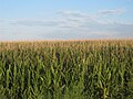 Cornfields flourish after a heavy rain in Prowers County, August 1, 2010


See also
- Outline of Colorado
- Index of Colorado-related articles
- National Register of Historic Places listings in Prowers County, Colorado
References
- "State & County QuickFacts". United States Census Bureau. Retrieved September 5, 2021.
- "Find a County". National Association of Counties. Retrieved June 7, 2011.
- "US Gazetteer files: 2010, 2000, and 1990". United States Census Bureau. February 12, 2011. Retrieved April 23, 2011.
- "Antipodes Map (AKA Tunnel Map)". www.findlatitudeandlongitude.com.
- "United States Antipodes". www.weathergraphics.com.
- "U.S. Decennial Census". United States Census Bureau. Retrieved June 10, 2014.
- "Historical Census Browser". University of Virginia Library. Retrieved June 10, 2014.
- "Population of Counties by Decennial Census: 1900 to 1990". United States Census Bureau. Retrieved June 10, 2014.
- "Census 2000 PHC-T-4. Ranking Tables for Counties: 1990 and 2000" (PDF). United States Census Bureau. Retrieved June 10, 2014.
- "U.S. Census website". United States Census Bureau. Retrieved February 28, 2018.
- Leip, David. "Dave Leip's Atlas of U.S. Presidential Elections". uselectionatlas.org. Retrieved May 26, 2017.
Notes
External links
- Prowers County Government website
- Colorado County Evolution by Don Stanwyck
- Colorado Historical Society
Places adjacent to Prowers County, Colorado | ||||||||||||||||
|---|---|---|---|---|---|---|---|---|---|---|---|---|---|---|---|---|
| ||||||||||||||||
Municipalities and communities of Prowers County, Colorado, United States | ||
|---|---|---|
County seat: Lamar | ||
| City |  | |
| Towns | ||
| Unincorporated communities |
| |
| ||
Denver (capital) | |
| Topics |
|
| Society |
|
| Cities |
|
| Counties |
|
| Regions |
|
Authority control | |
|---|---|
| General | |
| National libraries | |
На других языках
[de] Prowers County
Das Prowers County[3] ist ein County im Osten des US-Bundesstaats Colorado. Der Verwaltungssitz (County Seat) ist die größte Stadt des Countys, Lamar.- [en] Prowers County, Colorado
[ru] Проуэрс
Про́уэрс[1] (англ. Prowers County) — округ в штате Колорадо, США. Официально образован в 1889 году. По состоянию на 2010 год, численность населения составляла 12 551 человек.Другой контент может иметь иную лицензию. Перед использованием материалов сайта WikiSort.org внимательно изучите правила лицензирования конкретных элементов наполнения сайта.
WikiSort.org - проект по пересортировке и дополнению контента Википедии