world.wikisort.org - USA
Las Animas County is a county located in the U.S. state of Colorado. As of the 2020 census, the population was 14,555.[1] The county seat is Trinidad.[2] The county takes its name from the Mexican Spanish name of the Purgatoire River, originally called El Río de las Ánimas Perdidas en el Purgatorio, which means "River of the Lost Souls in Purgatory."[3]
Las Animas County | |
|---|---|
County | |
 Las Animas County Courthouse in Trinidad | |
 Location within the U.S. state of Colorado | |
 Colorado's location within the U.S. | |
| Coordinates: | |
| Country | |
| State | |
| Founded | February 9, 1866 |
| Named for | Purgatoire River |
| Seat | Trinidad |
| Area | |
| • Total | 4,775 sq mi (12,370 km2) |
| • Land | 4,773 sq mi (12,360 km2) |
| • Water | 2.7 sq mi (7 km2) 0.06% |
| Population (2020) | |
| • Total | 14,555 |
| Time zone | UTC−7 (Mountain) |
| • Summer (DST) | UTC−6 (MDT) |
| Area code | 719 |
| Website | lasanimascounty |

Geography
According to the U.S. Census Bureau, the county has a total area of 4,775 square miles (12,370 km2), of which 4,773 square miles (12,360 km2) is land and 2.7 square miles (7.0 km2) (0.06%) is water.[4] It is the largest county by area in Colorado.
Adjacent counties
- Otero County - north
- Pueblo County - north
- Bent County - northeast
- Baca County - east
- Union County, New Mexico - south
- Colfax County, New Mexico - southwest
- Costilla County- west
- Huerfano County - northwest
Major highways
 Interstate 25
 I-25 BL
 I-25 BS
 U.S. Highway 160
 U.S. Highway 350
 State Highway 12
 State Highway 109
 State Highway 389
Protected areas
- Comanche National Grassland
- Lake Dorothey State Wildlife Area
- James M. John State Wildlife Area
- San Isabel National Forest
- Spanish Peaks Wilderness
- Fishers Peak State Park
- Trinidad Lake State Park
Historic trails and landmarks
- Mesa de Maya
- Raton Pass National Historic Landmark
- Santa Fe National Historic Trail
- Trinidad State History Museum
Scenic byways
- Highway of Legends Scenic Byway
- Santa Fe Trail National Scenic Byway
Demographics
| Historical population | |||
|---|---|---|---|
| Census | Pop. | %± | |
| 1870 | 4,276 | — | |
| 1880 | 8,903 | 108.2% | |
| 1890 | 17,208 | 93.3% | |
| 1900 | 21,842 | 26.9% | |
| 1910 | 33,643 | 54.0% | |
| 1920 | 38,975 | 15.8% | |
| 1930 | 36,008 | −7.6% | |
| 1940 | 32,369 | −10.1% | |
| 1950 | 25,902 | −20.0% | |
| 1960 | 19,983 | −22.9% | |
| 1970 | 15,744 | −21.2% | |
| 1980 | 14,897 | −5.4% | |
| 1990 | 13,765 | −7.6% | |
| 2000 | 15,207 | 10.5% | |
| 2010 | 15,507 | 2.0% | |
| 2020 | 14,555 | −6.1% | |
| U.S. Decennial Census[5] 1790-1960[6] 1900-1990[7] 1990-2000[8] 2010-2020[1] | |||
At the 2000 census there were 15,207 people, 6,173 households, and 4,092 families living in the county. The population density was 3 people per square mile (1/km2). There were 7,629 housing units at an average density of 2 per square mile (1/km2). The racial makeup of the county was 82.63% White, 0.39% Black or African American, 2.54% Native American, 0.37% Asian, 0.20% Pacific Islander, 10.03% from other races, and 3.83% from two or more races. 41.45% of the population were Hispanic or Latino of any race.[9] Of the 6,173 households 28.80% had children under the age of 18 living with them, 49.90% were married couples living together, 11.60% had a female householder with no husband present, and 33.70% were non-families. 29.70% of households were one person and 14.30% were one person aged 65 or older. The average household size was 2.40 and the average family size was 2.97.
The age distribution was 24.20% under the age of 18, 7.90% from 18 to 24, 24.00% from 25 to 44, 25.90% from 45 to 64, and 18.00% 65 or older. The median age was 41 years. For every 100 females there were 95.80 males. For every 100 females age 18 and over, there were 93.70 males.
The median household income was $28,273 and the median family income was $34,072. Males had a median income of $27,182 versus $20,891 for females. The per capita income for the county was $16,829. About 14.00% of families and 17.30% of the population were below the poverty line, including 20.00% of those under age 18 and 17.20% of those age 65 or over.
Politics
A Democratic stronghold since the days of Franklin Roosevelt after having been solidly Republican during the "system of 1896" like the rest of Hispanic Colorado, Las Animas County has seen a strong trend toward the Republican Party in recent elections. Hillary Clinton's 2016 performance was the worst by a Democrat since John W. Davis in 1924. She was also the first Democrat to lose the county since George McGovern in 1972. In 2020, Joe Biden became the first Democrat to win the presidency without the county since Woodrow Wilson in 1912.
| Year | Republican | Democratic | Third party | |||
|---|---|---|---|---|---|---|
| No. | % | No. | % | No. | % | |
| 2020 | 4,284 | 53.81% | 3,497 | 43.93% | 180 | 2.26% |
| 2016 | 3,710 | 54.62% | 2,650 | 39.01% | 433 | 6.37% |
| 2012 | 3,263 | 47.55% | 3,445 | 50.20% | 154 | 2.24% |
| 2008 | 3,086 | 45.64% | 3,562 | 52.68% | 113 | 1.67% |
| 2004 | 3,196 | 48.48% | 3,300 | 50.06% | 96 | 1.46% |
| 2000 | 2,569 | 42.16% | 3,243 | 53.22% | 282 | 4.63% |
| 1996 | 1,905 | 31.53% | 3,611 | 59.76% | 526 | 8.71% |
| 1992 | 1,739 | 26.47% | 3,847 | 58.56% | 983 | 14.96% |
| 1988 | 2,162 | 34.15% | 4,075 | 64.37% | 94 | 1.48% |
| 1984 | 2,992 | 44.38% | 3,670 | 54.43% | 80 | 1.19% |
| 1980 | 2,917 | 39.37% | 4,117 | 55.57% | 375 | 5.06% |
| 1976 | 2,615 | 36.45% | 4,459 | 62.15% | 101 | 1.41% |
| 1972 | 3,659 | 52.59% | 3,222 | 46.31% | 76 | 1.09% |
| 1968 | 2,499 | 33.30% | 4,602 | 61.33% | 403 | 5.37% |
| 1964 | 1,833 | 21.68% | 6,591 | 77.97% | 29 | 0.34% |
| 1960 | 2,989 | 30.74% | 6,704 | 68.96% | 29 | 0.30% |
| 1956 | 5,290 | 50.80% | 5,099 | 48.96% | 25 | 0.24% |
| 1952 | 4,467 | 40.74% | 6,446 | 58.79% | 51 | 0.47% |
| 1948 | 3,452 | 30.79% | 7,586 | 67.67% | 172 | 1.53% |
| 1944 | 4,179 | 37.87% | 6,800 | 61.63% | 55 | 0.50% |
| 1940 | 4,859 | 35.53% | 8,766 | 64.10% | 50 | 0.37% |
| 1936 | 3,333 | 24.49% | 10,220 | 75.08% | 59 | 0.43% |
| 1932 | 3,651 | 28.35% | 8,964 | 69.61% | 262 | 2.03% |
| 1928 | 5,367 | 44.74% | 6,459 | 53.85% | 169 | 1.41% |
| 1924 | 5,698 | 48.68% | 2,758 | 23.56% | 3,250 | 27.76% |
| 1920 | 4,707 | 51.19% | 4,167 | 45.31% | 322 | 3.50% |
| 1916 | 3,511 | 38.81% | 5,300 | 58.58% | 236 | 2.61% |
| 1912 | 4318 | 43.82% | 3,604 | 36.57% | 1,932 | 19.61% |
Communities


City
Towns
Census-designated places
Unincorporated communities
Ghost towns
See also
- Outline of Colorado
- Index of Colorado-related articles
- Colorado census statistical areas
- National Register of Historic Places listings in Las Animas County, Colorado
References
- "State & County QuickFacts". United States Census Bureau. Retrieved September 5, 2021.
- "Find a County". National Association of Counties. Retrieved June 7, 2011.
- Gannett, Henry (1905). The Origin of Certain Place Names in the United States. U.S. Government Printing Office. p. 182.
- "US Gazetteer files: 2010, 2000, and 1990". United States Census Bureau. February 12, 2011. Retrieved April 23, 2011.
- "U.S. Decennial Census". United States Census Bureau. Retrieved June 8, 2014.
- "Historical Census Browser". University of Virginia Library. Retrieved June 8, 2014.
- "Population of Counties by Decennial Census: 1900 to 1990". United States Census Bureau. Retrieved June 8, 2014.
- "Census 2000 PHC-T-4. Ranking Tables for Counties: 1990 and 2000" (PDF). United States Census Bureau. Archived (PDF) from the original on March 27, 2010. Retrieved June 8, 2014.
- "U.S. Census website". United States Census Bureau. Retrieved May 14, 2011.
- Leip, David. "Dave Leip's Atlas of U.S. Presidential Elections". uselectionatlas.org. Retrieved May 26, 2017.
External links
Places adjacent to Las Animas County, Colorado | ||||||||||||||||
|---|---|---|---|---|---|---|---|---|---|---|---|---|---|---|---|---|
| ||||||||||||||||
Municipalities and communities of Las Animas County, Colorado, United States | ||
|---|---|---|
County seat: Trinidad | ||
| City | 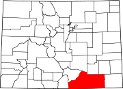 | |
| Towns | ||
| CDPs | ||
| Unincorporated communities | ||
| Ghost towns | ||
| ||
Authority control | |
|---|---|
| General | |
| National libraries | |
| Other | |
На других языках
[de] Las Animas County
Las Animas County[1] (kurz: Las Animas) ist ein County im Bundesstaat Colorado der Vereinigten Staaten. Im Jahr 2000 betrug die Bevölkerung 15.207 Einwohner. Der Verwaltungssitz (County Seat) ist Trinidad.- [en] Las Animas County, Colorado
[it] Contea di Las Animas
La contea di Las Animas in inglese Las Animas County è una contea dello Stato del Colorado, negli Stati Uniti. La popolazione al censimento del 2000 era di 15 207 abitanti. Il capoluogo di contea è Trinidad.[ru] Лас-Анимас (округ)
Лас-А́нимас[1] (англ. Las Animas County) — округ в штате Колорадо, США. Является самым большим в штате и третьим по величине округом в США.Другой контент может иметь иную лицензию. Перед использованием материалов сайта WikiSort.org внимательно изучите правила лицензирования конкретных элементов наполнения сайта.
WikiSort.org - проект по пересортировке и дополнению контента Википедии