world.wikisort.org - USA
Holyoke is the home rule municipality that is the county seat and the most populous municipality of Phillips County, Colorado, United States.[6] The city population was 2,346 at the 2020 United States Census.[3]
Holyoke, Colorado | |
|---|---|
Home rule municipality[1] | |
 The Phillips County Courthouse in Holyoke, 2013. | |
| Motto(s): "It's not what you show, it's what you grow." | |
 Location of the City of Holyoke in Phillips County, Colorado. | |
 Holyoke Location of the City of Holyoke in the United States. | |
| Coordinates: 40°34′55″N 102°18′4″W | |
| Country | |
| State | |
| County | Phillips County[1] |
| City | Holyoke[1] |
| Incorporated | May 31, 1888[2] |
| Government | |
| • Type | Home Rule Municipality[1] |
| • Mayor | Orville Tonsing |
| Area | |
| • Total | 2.476 sq mi (6.414 km2) |
| • Land | 2.470 sq mi (6.396 km2) |
| • Water | 0.007 sq mi (0.018 km2) |
| Elevation | 3,750 ft (1,143 m) |
| Population (2020)[3] | |
| • Total | 2,346 |
| • Density | 950/sq mi (370/km2) |
| Time zone | UTC−07:00 (MST) |
| • Summer (DST) | UTC−06:00 (MDT) |
| ZIP code[5] | 80734 |
| Area code | 970 |
| FIPS code | 08-37270 |
| GNIS feature ID | 0182823 |
| Website | Holyoke CoC |
History
The city is named after Holyoke, Massachusetts, which is itself named for Elizur Holyoke, a 17th-century explorer.[7]
Geography

Holyoke is located at 40°34′55″N 102°18′4″W (40.582002, -102.301056).[8]
At the 2020 United States Census, the town had a total area of 1,585 acres (6.414 km2) including 4.4 acres (0.018 km2) of water.[3]
Climate
According to the Köppen Climate Classification system, Holyoke has a cold semi-arid climate, abbreviated "BSk" on climate maps.
| Climate data for Holyoke, Colorado, 1991–2020 normals, extremes 1897–present | |||||||||||||
|---|---|---|---|---|---|---|---|---|---|---|---|---|---|
| Month | Jan | Feb | Mar | Apr | May | Jun | Jul | Aug | Sep | Oct | Nov | Dec | Year |
| Record high °F (°C) | 76 (24) |
80 (27) |
89 (32) |
91 (33) |
99 (37) |
110 (43) |
110 (43) |
107 (42) |
105 (41) |
98 (37) |
88 (31) |
80 (27) |
110 (43) |
| Mean maximum °F (°C) | 64.0 (17.8) |
68.0 (20.0) |
77.6 (25.3) |
84.0 (28.9) |
90.7 (32.6) |
97.5 (36.4) |
100.3 (37.9) |
98.1 (36.7) |
94.6 (34.8) |
86.9 (30.5) |
75.4 (24.1) |
64.9 (18.3) |
101.8 (38.8) |
| Average high °F (°C) | 41.6 (5.3) |
44.2 (6.8) |
54.1 (12.3) |
61.8 (16.6) |
70.9 (21.6) |
82.5 (28.1) |
88.0 (31.1) |
86.2 (30.1) |
78.6 (25.9) |
65.2 (18.4) |
52.5 (11.4) |
42.3 (5.7) |
64.0 (17.8) |
| Daily mean °F (°C) | 27.2 (−2.7) |
29.4 (−1.4) |
38.4 (3.6) |
46.4 (8.0) |
56.7 (13.7) |
67.8 (19.9) |
73.3 (22.9) |
71.1 (21.7) |
62.6 (17.0) |
49.0 (9.4) |
37.0 (2.8) |
27.6 (−2.4) |
48.9 (9.4) |
| Average low °F (°C) | 12.7 (−10.7) |
14.5 (−9.7) |
22.7 (−5.2) |
31.1 (−0.5) |
42.5 (5.8) |
53.1 (11.7) |
58.6 (14.8) |
56.0 (13.3) |
46.6 (8.1) |
32.9 (0.5) |
21.4 (−5.9) |
13.0 (−10.6) |
33.8 (1.0) |
| Mean minimum °F (°C) | −6.2 (−21.2) |
−3.1 (−19.5) |
6.8 (−14.0) |
19.0 (−7.2) |
29.1 (−1.6) |
43.6 (6.4) |
51.9 (11.1) |
48.0 (8.9) |
34.4 (1.3) |
18.1 (−7.7) |
6.5 (−14.2) |
−4.3 (−20.2) |
−13.0 (−25.0) |
| Record low °F (°C) | −27 (−33) |
−36 (−38) |
−23 (−31) |
−4 (−20) |
8 (−13) |
30 (−1) |
37 (3) |
36 (2) |
16 (−9) |
−12 (−24) |
−12 (−24) |
−35 (−37) |
−36 (−38) |
| Average precipitation inches (mm) | 0.32 (8.1) |
0.51 (13) |
0.86 (22) |
1.92 (49) |
2.83 (72) |
2.76 (70) |
2.75 (70) |
2.39 (61) |
1.40 (36) |
1.23 (31) |
0.52 (13) |
0.44 (11) |
17.93 (456.1) |
| Average snowfall inches (cm) | 4.5 (11) |
6.1 (15) |
4.4 (11) |
3.7 (9.4) |
0.2 (0.51) |
0.0 (0.0) |
0.0 (0.0) |
0.0 (0.0) |
0.2 (0.51) |
1.9 (4.8) |
3.9 (9.9) |
5.5 (14) |
30.4 (76.12) |
| Average precipitation days (≥ 0.01 in) | 3.1 | 5.0 | 5.5 | 8.5 | 10.6 | 9.3 | 9.4 | 7.9 | 5.9 | 5.8 | 3.8 | 3.6 | 78.4 |
| Average snowy days (≥ 0.1 in) | 2.7 | 4.0 | 2.9 | 1.8 | 0.2 | 0.0 | 0.0 | 0.0 | 0.1 | 1.0 | 2.3 | 3.3 | 18.3 |
| Source 1: NOAA[9] | |||||||||||||
| Source 2: National Weather Service[10] | |||||||||||||
Demographics
| Historical population | |||
|---|---|---|---|
| Census | Pop. | %± | |
| 1890 | 649 | — | |
| 1900 | 451 | −30.5% | |
| 1910 | 659 | 46.1% | |
| 1920 | 1,205 | 82.9% | |
| 1930 | 1,226 | 1.7% | |
| 1940 | 1,150 | −6.2% | |
| 1950 | 1,558 | 35.5% | |
| 1960 | 1,555 | −0.2% | |
| 1970 | 1,640 | 5.5% | |
| 1980 | 2,092 | 27.6% | |
| 1990 | 1,931 | −7.7% | |
| 2000 | 2,261 | 17.1% | |
| 2010 | 2,313 | 2.3% | |
| 2020 | 2,346 | 1.4% | |
| U.S. Decennial Census | |||
As of the census[11] of 2000, there were 2,261 people, 896 households, and 594 families residing in the city. The population density was 1,300.3 inhabitants per square mile (502.0/km2). There were 980 housing units at an average density of 563.6 per square mile (217.6/km2). The racial makeup of the city was 89.61% White, 0.04% African American, 0.31% Native American, 0.57% Asian, 8.09% from other races, and 1.37% from two or more races. Hispanic or Latino of any race were 20.39% of the population.
There were 896 households, out of which 34.4% had children under the age of 18 living with them, 57.9% were married couples living together, 6.3% had a female householder with no husband present, and 33.7% were non-families. 30.6% of all households were made up of individuals, and 16.0% had someone living alone who was 65 years of age or older. The average household size was 2.47 and the average family size was 3.11.
In the city, the population was spread out, with 28.3% under the age of 18, 6.4% from 18 to 24, 26.6% from 25 to 44, 20.1% from 45 to 64, and 18.7% who were 65 years of age or older. The median age was 38 years. For every 100 females, there were 90.2 males. For every 100 females age 18 and over, there were 86.7 males.
The median income for a household in the city was $30,984, and the median income for a family was $36,970. Males had a median income of $30,500 versus $17,455 for females. The per capita income for the city was $15,697. About 12.0% of families and 14.6% of the population were below the poverty line, including 21.1% of those under age 18 and 8.4% of those age 65 or over.
Notable residents
- Greg Brophy (b. 1966), former state senator
- Bill Brundige (1948–2018), American football defensive end
- Mike Groene (b. 1955), politician
- Dorothy Horrell (b. 1951), Chancellor of University of Colorado Denver
- Charles B. Timberlake (1854–1941), U.S. Congressman from Colorado
See also
- Colorado
- Bibliography of Colorado
- Index of Colorado-related articles
- Outline of Colorado
- List of counties in Colorado
- List of municipalities in Colorado
- List of places in Colorado
- Patricia (Pat) Hepinstall, one of the first women to fly to Antarctica
- W. E. Heginbotham House
References
- "Active Colorado Municipalities". Colorado Department of Local Affairs. Retrieved December 28, 2021.
- "Colorado Municipal Incorporations". State of Colorado, Department of Personnel & Administration, Colorado State Archives. 2004-12-01. Retrieved 2007-09-02.
- "QuickFacts for Colorado". United States Census Bureau. Retrieved December 28, 2021.
- "US Board on Geographic Names". United States Geological Survey. 2007-10-25. Retrieved 2008-01-31.
- "ZIP Code Lookup". United States Postal Service. Archived from the original (JavaScript/HTML) on November 4, 2010. Retrieved October 6, 2007.
- "Find a County". National Association of Counties. Archived from the original on 2011-05-31. Retrieved 2011-06-07.
- Gannett, Henry (1905). The Origin of Certain Place Names in the United States. Govt. Print. Off. pp. 159.
- "US Gazetteer files: 2010, 2000, and 1990". United States Census Bureau. 2011-02-12. Retrieved 2011-04-23.
- "U.S. Climate Normals Quick Access". National Oceanic and Atmospheric Administration. Retrieved August 8, 2022.
- "NOAA Online Weather Data". National Weather Service. Retrieved August 8, 2022.
- "U.S. Census website". United States Census Bureau. Retrieved 2008-01-31.
External links
Municipalities and communities of Phillips County, Colorado, United States | ||
|---|---|---|
County seat: Holyoke | ||
| City | 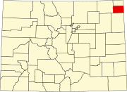 | |
| Towns | ||
| CDP | ||
| ||
Authority control | |
|---|---|
| General | |
| National libraries | |
На других языках
[de] Holyoke (Colorado)
Holyoke ist der County Seat des Phillips County im US-Bundesstaat Colorado. 2010 hatte Holyoke 2313 Einwohner.- [en] Holyoke, Colorado
Другой контент может иметь иную лицензию. Перед использованием материалов сайта WikiSort.org внимательно изучите правила лицензирования конкретных элементов наполнения сайта.
WikiSort.org - проект по пересортировке и дополнению контента Википедии