world.wikisort.org - USA
The City of Salida (/səˈlaɪdə/ sə-LY-də; Spanish: [saˈliða], "exit") is the Statutory city that is the county seat and the most populous municipality of Chaffee County, Colorado, United States.[7] The population was 5,666 at the 2020 census.[8]
Salida, Colorado | |
|---|---|
Statutory city[1] | |
| City of Salida[1] | |
 The Arkansas River Walk in downtown Salida. | |
| Nickname: Heart of the Rockies | |
| Motto(s): "Union, Justice, Safety" | |
 Location of the City of Salida in Chaffee County, Colorado. | |
 Salida Location of the City of Salida in the United States. | |
| Coordinates: 38°31′53″N 105°59′46″W | |
| Country | |
| State | |
| County | Chaffee County[2] |
| City | Salida[1] |
| Founded | 1880 |
| Incorporated | March 23, 1891[3] |
| Government | |
| • Type | Statutory city[1] |
| Area | |
| • Total | 2.77 sq mi (7.17 km2) |
| • Land | 2.77 sq mi (7.17 km2) |
| • Water | 0.00 sq mi (0.00 km2) |
| Elevation | 7,083 ft (2,159 m) |
| Population (2010) | |
| • Total | 5,236 |
| • Estimate (2019)[5] | 6,082 |
| • Density | 2,197.25/sq mi (848.23/km2) |
| Time zone | UTC−7 (Mountain (MST)) |
| • Summer (DST) | UTC−6 (MDT) |
| ZIP codes[6] | 81201, 81227 (PO Box), 81237 |
| Area code | 719 |
| FIPS code | 08-67280 |
| GNIS feature ID | 0204758 |
| Website | Official website |
History
A post office has been in operation at Salida since 1881.[9] Salida meaning "exit" in Spanish, the community was named on account of its location near where the Arkansas River flows out of the valley and into Bighorn Sheep Canyon, upstream from the Royal Gorge.[10]
 Map of Salida, 1882
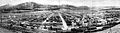 Panoramic View of Salida, 1910
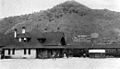 Salida Depot, 1910


Geography
According to the United States Census Bureau, the city has a total area of 2.77 square miles (7.2 km2), and the Arkansas River, which runs through the town, is the major source of water for local agriculture.
The Sawatch Range runs north and south and is located roughly 10 miles (16 km) west of Salida. The Mosquito Range parallels the Sawatch Range to the east, forming the Upper Arkansas Valley, and the southern terminus of the range, just east of Salida, is known locally as the Arkansas Hills. Methodist Mountain, which is a major feature on Salida's southern horizon, is the northernmost mountain in the Sangre de Cristo Mountains. To the north of Salida is the Upper Arkansas Valley and the town of Buena Vista.
U.S. Route 50 runs along the southern edge of the city and leads east down the Arkansas River 58 miles (93 km) to Cañon City; to the west it leads 4 miles (6 km) to Poncha Springs and 63 miles (101 km) over the Continental Divide to Gunnison. Canon City and Pueblo lie to the east.
Climate
According to the Köppen climate classification, Salida has a Cold semi-arid climate (BSk)
| Climate data for Salida, Colorado (1981–2010) | |||||||||||||
|---|---|---|---|---|---|---|---|---|---|---|---|---|---|
| Month | Jan | Feb | Mar | Apr | May | Jun | Jul | Aug | Sep | Oct | Nov | Dec | Year |
| Average high °F (°C) | 43.3 (6.3) |
45.5 (7.5) |
52.6 (11.4) |
60.5 (15.8) |
70.3 (21.3) |
80.0 (26.7) |
85.2 (29.6) |
82.0 (27.8) |
75.2 (24.0) |
64.6 (18.1) |
51.9 (11.1) |
42.5 (5.8) |
62.8 (17.1) |
| Average low °F (°C) | 12.1 (−11.1) |
15.2 (−9.3) |
21.0 (−6.1) |
27.8 (−2.3) |
35.6 (2.0) |
42.2 (5.7) |
48.3 (9.1) |
46.6 (8.1) |
38.5 (3.6) |
28.6 (−1.9) |
20.3 (−6.5) |
12.6 (−10.8) |
29.1 (−1.6) |
| Average precipitation inches (mm) | 0.29 (7.4) |
0.30 (7.6) |
0.59 (15) |
0.94 (24) |
0.89 (23) |
0.65 (17) |
1.24 (31) |
1.61 (41) |
0.78 (20) |
0.95 (24) |
0.34 (8.6) |
0.30 (7.6) |
8.89 (226) |
| Average snowfall inches (cm) | 5.5 (14) |
5.2 (13) |
7.2 (18) |
6.0 (15) |
2.1 (5.3) |
0.0 (0.0) |
0.0 (0.0) |
0.0 (0.0) |
0.1 (0.25) |
4.5 (11) |
6.9 (18) |
5.3 (13) |
42.9 (109) |
| Source: NOAA[11] | |||||||||||||
Demographics
| Historical population | |||
|---|---|---|---|
| Census | Pop. | %± | |
| 1890 | 2,586 | — | |
| 1900 | 3,722 | 43.9% | |
| 1910 | 4,425 | 18.9% | |
| 1920 | 4,689 | 6.0% | |
| 1930 | 5,065 | 8.0% | |
| 1940 | 4,969 | −1.9% | |
| 1950 | 4,553 | −8.4% | |
| 1960 | 4,560 | 0.2% | |
| 1970 | 4,355 | −4.5% | |
| 1980 | 4,870 | 11.8% | |
| 1990 | 4,737 | −2.7% | |
| 2000 | 5,504 | 16.2% | |
| 2010 | 5,236 | −4.9% | |
| 2019 (est.) | 6,082 | [5] | 16.2% |
| U.S. Decennial Census[12] | |||
At the 2000 census there were 5,504 people, 2,504 households, and 1,449 families living in the city. The population density was 2,480.1 inhabitants per square mile (957.6/km2). There were 2,748 housing units at an average density of 1,238.3 per square mile (478.1/km2). The racial makeup of the city was 92.66% White, 0.05% African American, 1.44% Native American, 0.38% Asian, 0.02% Pacific Islander, 3.29% from other races, and 2.16% from two or more races. Hispanic or Latino of any race were 10.76%.[13]
Of the 2,504 households 25.0% had children under the age of 18 living with them, 45.9% were married couples living together, 8.6% had a female householder with no husband present, and 42.1% were non-families. 35.9% of households were one person and 15.4% were one person aged 65 or older. The average household size was 2.15 and the average family size was 2.80.
The age distribution was 21.4% under the age of 18, 6.3% from 18 to 24, 27.5% from 25 to 44, 24.2% from 45 to 64, and 20.6% 65 or older. The median age was 42 years. For every 100 females, there were 94.6 males. For every 100 females age 18 and over, there were 92.7 males.
The median household income was $28,790 and the median family income was $38,240. Males had a median income of $30,447 versus $20,867 for females. The per capita income for the city was $17,252. About 9.2% of families and 14.8% of the population were below the poverty line, including 23.7% of those under age 18 and 13.7% of those age 65 or over.
Education
The city is served by Salida Public Schools. There are two public high schools, Salida High School and Horizons Exploratory Academy; and three middle schools, Salida Middle School, Salida Montessori Charter School, and the Crest Academy. Colorado Mountain College also has a campus in Salida.
Infrastructure
Health care
Salida and Chaffee County are served by the Heart of the Rockies Regional Medical Center, located on the north side of Town on Rush Drive.
Transportation
Salida is part of Colorado's Bustang network. It is on both the Alamosa-Pueblo and the Gunnison-Denver Outrider lines.[14]
Culture
The Salida Downtown Historic District was added to the National Register of Historic Places in 1984 and is the largest historic district in Colorado.[15] On March 30, 2012, downtown Salida was named one of two inaugural Certified Creative Districts in Colorado.[16] Salida is also home to the Shavano Chapter of the Columbine Poets of Colorado, which is affiliated with the National Federation of State Poetry Societies (NFSPS). The group organizes workshops and festivals and offers poetry contests for both adults and students.[17] On March 30, 2012, Colorado by Colorado Creative Industries, a division of the State’s Office of Economic Development and International Trade, announced that the City of Salida’s historic downtown was selected as one of only two inaugural “Certified Creative Districts” in Colorado.[18]
Notable people
- Sally Blane, actress
- Louie Croft Boyd, Superintendent of Nurses, Rio Grande Hospital
- Chris Guccione, Major League Baseball umpire
- Kent Haruf, novelist
- Ruth Hinshaw Spray, peace activist
See also
- Outline of Colorado
- Index of Colorado-related articles
- State of Colorado
- Colorado cities and towns
- Colorado municipalities
- Colorado counties
- Colorado cities and towns
References
- "Active Colorado Municipalities". State of Colorado, Colorado Department of Local Affairs, Division of Local Government. Retrieved January 31, 2021.
- "Colorado Counties". State of Colorado, Colorado Department of Local Affairs, Division of Local Government. Retrieved January 31, 2021.
- "Colorado Municipal Incorporations". State of Colorado, Department of Personnel & Administration, Colorado State Archives. 2004-12-01. Retrieved 2007-09-02.
- "2019 U.S. Gazetteer Files". United States Census Bureau. Retrieved July 1, 2020.
- "Population and Housing Unit Estimates". United States Census Bureau. May 24, 2020. Retrieved May 27, 2020.
- "ZIP Code Lookup". United States Postal Service. Archived from the original (JavaScript/HTML) on September 3, 2007. Retrieved January 1, 2008.
- "Find a County". National Association of Counties. Retrieved 2011-06-07.
- "U.S. Census Bureau QuickFacts: Salida city, Colorado". www.census.gov. Retrieved 2022-01-06.
- "Post offices". Jim Forte Postal History. Retrieved 9 July 2016.
- Dawson, John Frank. Place names in Colorado: why 700 communities were so named, 150 of Spanish or Indian origin. Denver, CO: The J. Frank Dawson Publishing Co. p. 44.
- "NOWData - NOAA Online Weather Data". National Oceanic and Atmospheric Administration. Retrieved May 5, 2013.
- "Census of Population and Housing". Census.gov. Retrieved June 4, 2015.
- "U.S. Census website". United States Census Bureau. Retrieved 2008-01-31.
- "Bustang Schedule". RideBustang. CDOT.
- "Salida National Historic District". Buena Vista & Salida, Colorado Vacation. 2017-12-13. Retrieved 2021-11-19.
- "Salida Creative District Strategic Plan » Salida Creative District". Retrieved 2021-11-19.
- "Who Are The Columbine Poets?". Retrieved 28 October 2020.
- "About the Salida Creative District » Salida Creative District". Retrieved 2022-01-06.
External links
Municipalities and communities of Chaffee County, Colorado, United States | ||
|---|---|---|
County seat: Salida | ||
| City | 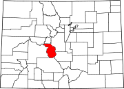 | |
| Towns | ||
| CDPs | ||
| Unincorporated communities | ||
| ||
Authority control | |
|---|---|
| General | |
| National libraries | |
| Other | |
На других языках
[de] Salida (Colorado)
Salida ist eine Kleinstadt im US-Bundesstaat Colorado. Sie liegt im zentralen Teil des Staates in einem weiten Tal des Arkansas, das von der Sawatch-, der Sangre de Cristo- sowie der Mosquito Range umschlossen wird.- [en] Salida, Colorado
Другой контент может иметь иную лицензию. Перед использованием материалов сайта WikiSort.org внимательно изучите правила лицензирования конкретных элементов наполнения сайта.
WikiSort.org - проект по пересортировке и дополнению контента Википедии