world.wikisort.org - USA
Ordway is a Statutory Town in and the county seat of Crowley County, Colorado, United States, that is also the most populous community in the county.[7] The population was 1,080 at the 2010 census.[8]
Ordway, Colorado | |
|---|---|
Town | |
 Main Street in Ordway, June 2017 | |
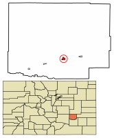 Location of Ordway in Crowley County, Colorado. | |
| Coordinates: 38°13′11″N 103°45′26″W | |
| Country | |
| State | |
| County[1] | Crowley County Seat |
| Incorporated (town) | September 4, 1900[2] |
| Government | |
| • Type | Statutory Town[1] |
| Area | |
| • Total | 0.77 sq mi (2.00 km2) |
| • Land | 0.77 sq mi (2.00 km2) |
| • Water | 0.00 sq mi (0.00 km2) |
| Elevation | 4,311 ft (1,314 m) |
| Population (2010) | |
| • Total | 1,080 |
| • Estimate (2019)[5] | 1,054 |
| • Density | 1,367.06/sq mi (527.57/km2) |
| Time zone | UTC-7 (Mountain (MST)) |
| • Summer (DST) | UTC-6 (MDT) |
| ZIP code[6] | 81063 |
| Area code | 719 |
| FIPS code | 08-56145 |
| GNIS feature ID | 0203804 |
| Website | www |
History
A post office called Ordway has been in operation since 1890.[9] The community was named after George N. Ordway, a Denver politician.[10]
Geography
Ordway is located in south-central Crowley County at 38°13′11″N 103°45′26″W (38.219633, -103.757264).[11] State Highway 96 runs along the southern edge of the town, leading west 49 miles (79 km) to Pueblo and east 60 miles (97 km) to Eads. Highway 71 runs along the eastern edge of the town and leads south 11 miles (18 km) to U.S. Route 50 near Rocky Ford and north 75 miles (121 km) to Interstate 70 at Limon.
According to the United States Census Bureau, Ordway has a total area of 0.8 square miles (2.1 km2), all of it land.
Demographics
| Historical population | |||
|---|---|---|---|
| Census | Pop. | %± | |
| 1900 | 138 | — | |
| 1910 | 705 | 410.9% | |
| 1920 | 1,186 | 68.2% | |
| 1930 | 1,139 | −4.0% | |
| 1940 | 1,150 | 1.0% | |
| 1950 | 1,290 | 12.2% | |
| 1960 | 1,254 | −2.8% | |
| 1970 | 1,017 | −18.9% | |
| 1980 | 1,135 | 11.6% | |
| 1990 | 1,025 | −9.7% | |
| 2000 | 1,248 | 21.8% | |
| 2010 | 1,080 | −13.5% | |
| 2019 (est.) | 1,054 | [5] | −2.4% |
| U.S. Decennial Census[12] | |||
As of the census[13] of 2000, there were 1,248 people, 485 households, and 317 families residing in the town. The population density was 1,613.4 inhabitants per square mile (622.9/km2). There were 543 housing units at an average density of 702.0 per square mile (271.0/km2). The racial makeup of the town was 84.78% White, 0.40% African American, 2.48% Native American, 0.40% Asian, 9.21% from other races, and 2.72% from two or more races. Hispanic or Latino of any race were 31.25% of the population.
There were 485 households, out of which 33.6% had children under the age of 18 living with them, 45.2% were married couples living together, 14.8% had a female householder with no husband present, and 34.6% were non-families. 31.5% of all households were made up of individuals, and 17.5% had someone living alone who was 65 years of age or older. The average household size was 2.47 and the average family size was 3.09.
In the town, the population was spread out, with 28.8% under the age of 18, 8.6% from 18 to 24, 24.4% from 25 to 44, 19.8% from 45 to 64, and 18.5% who were 65 years of age or older. The median age was 37 years. For every 100 females, there were 90.5 males. For every 100 females age 18 and over, there were 82.2 males.
The median income for a household in the town was $23,967, and the median income for a family was $29,107. Males had a median income of $25,139 versus $26,607 for females. The per capita income for the town was $14,334. About 20.0% of families and 21.4% of the population were below the poverty line, including 26.8% of those under age 18 and 13.4% of those age 65 or over.
See also
- List of municipalities in Colorado
References
- "Active Colorado Municipalities". State of Colorado, Department of Local Affairs. Archived from the original on 2009-12-12. Retrieved 2007-09-01.
- "Colorado Municipal Incorporations". State of Colorado, Department of Personnel & Administration, Colorado State Archives. 2004-12-01. Retrieved 2007-09-02.
- "2019 U.S. Gazetteer Files". United States Census Bureau. Retrieved July 1, 2020.
- "US Board on Geographic Names". United States Geological Survey. 2007-10-25. Retrieved 2008-01-31.
- "Population and Housing Unit Estimates". United States Census Bureau. May 24, 2020. Retrieved May 27, 2020.
- "ZIP Code Lookup". United States Postal Service. Archived from the original (JavaScript/HTML) on November 4, 2010. Retrieved November 28, 2007.
- "Find a County". National Association of Counties. Archived from the original on May 31, 2011. Retrieved 2011-06-07.
- "Geographic Identifiers: 2010 Demographic Profile Data (G001): Ordway town, Colorado". U.S. Census Bureau, American Factfinder. Archived from the original on February 12, 2020. Retrieved June 24, 2014.
- "Post offices". Jim Forte Postal History. Retrieved 6 July 2016.
- Dawson, John Frank. Place names in Colorado: why 700 communities were so named, 150 of Spanish or Indian origin. Denver, CO: The J. Frank Dawson Publishing Co. p. 38.
- "US Gazetteer files: 2010, 2000, and 1990". United States Census Bureau. 2011-02-12. Retrieved 2011-04-23.
- "Census of Population and Housing". Census.gov. Retrieved June 4, 2015.
- "U.S. Census website". United States Census Bureau. Retrieved 2008-01-31.
External links
Municipalities and communities of Crowley County, Colorado, United States | ||
|---|---|---|
County seat: Ordway | ||
| Towns |  | |
| ||
Другой контент может иметь иную лицензию. Перед использованием материалов сайта WikiSort.org внимательно изучите правила лицензирования конкретных элементов наполнения сайта.
WikiSort.org - проект по пересортировке и дополнению контента Википедии