world.wikisort.org - USA
The Town of Pagosa Springs (Ute language: Pagwöösa, Navajo language: Tó Sido Háálį́) is a home rule municipality that is the county seat, the most populous community, and the only incorporated municipality in Archuleta County, Colorado, United States.[1][7] The population was 1,727 at the 2010 census.[8] Approximately 65 percent of the land in Archuleta County is either San Juan National Forest, Weminuche and South San Juan Wilderness areas, or Southern Ute Indian reservation land.
Pagosa Springs, Colorado | |
|---|---|
Town | |
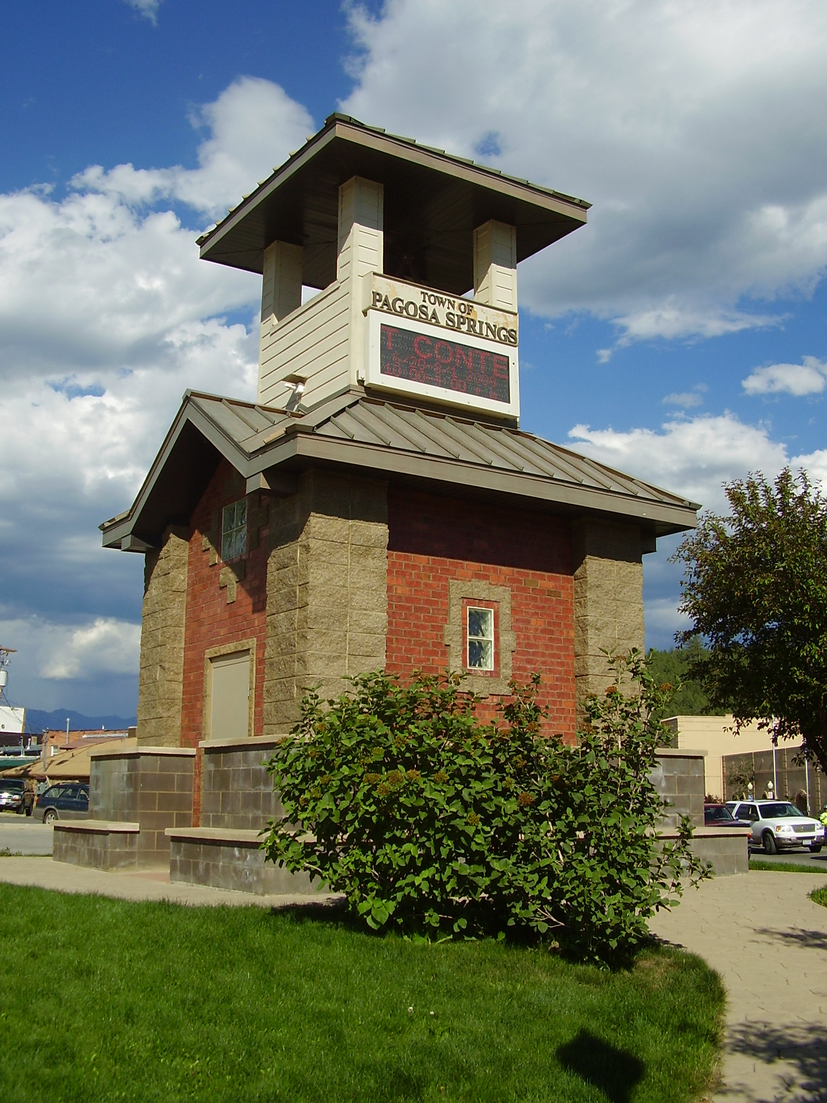 Tower at Pagosa Springs | |
 Location of Pagosa Springs in Archuleta County, Colorado. | |
| Coordinates: 37°16′5″N 107°1′28″W | |
| Country | |
| State | |
| County[1] | Archuleta County Seat |
| Incorporated (town) | March 18, 1891[2] |
| Government | |
| • Type | Home rule municipality[1] |
| • Mayor | Shari Pierce |
| Area | |
| • Total | 5.06 sq mi (13.10 km2) |
| • Land | 5.03 sq mi (13.04 km2) |
| • Water | 0.03 sq mi (0.07 km2) |
| Elevation | 7,126 ft (2,172 m) |
| Population (2010) | |
| • Total | 1,727 |
| • Estimate (2019)[5] | 2,085 |
| • Density | 414.27/sq mi (159.94/km2) |
| Time zone | UTC-7 (Mountain (MST)) |
| • Summer (DST) | UTC-6 (MDT) |
| ZIP Codes[6] | 81147, 81157 (PO Box) |
| Area code | 970 |
| FIPS code | 08-56860 |
| GNIS feature ID | 0184338 |
| Website | visitpagosasprings |
Pagosa Springs and the surrounding county are both experiencing a substantial influx of second-home owners; a 2006 property assessment indicates that 60% of area private properties are owned by non-residents.
Pagosa Springs is located approximately 35 miles (56 km) north of the New Mexico border, at 7,126 feet (2,172 m) above sea level on the Western Slope of the Continental Divide. This combination of high desert plateau and the Rocky Mountains to the north and east creates an unusually mild climate, especially in the summer months. Pagosa sees around 300 days of sun each year, as well as four distinct seasons.[9]
The town is located in the upper San Juan Basin, surrounded by the 3-million-acre (4,700 sq mi; 12,000 km2) San Juan National Forest, and adjacent to the largest wilderness area in the state of Colorado, the Weminuche Wilderness.
The town is named for a system of sulfur springs, Pagosa hot springs, located there, which includes the world's deepest geothermal hot spring.[10] The "Mother" spring feeds primitive and developed hot springs located on the upper banks of the San Juan River, which flows through town. The primitive springs are freely accessible to the public, but are generally not for entering or interacting with because of the extreme water temperature. Developed springs feed soaking pools that are hosted by three privately-owned soaking locations within town.[11] The water from the "Mother" spring is approximately 144 °F (62 °C).
History
Local indigenous people used the hot springs for centuries; the area was considered "sacred ground". In Navajo cosmology, Pagosa Springs is the place where the People (Diné) emerged from their Fourth World underground to the Fifth World, this one, as Aileen O'Bryan records in The Dîné: Origin Myths of the Navaho Indians.[12] In 1859, a white settler "discovered" the springs and exploited them. In 1881, a bathhouse was first built there for paying customers.[13]
The Ute people called the sulfur-rich mineral springs Pah gosah, which is commonly translated in modern documents as "healing waters"; a Ute elder once translated the phrase as "water (pah) that has a bad smell (gosah)."[14]
After the Civil War, the United States government considered building a convalescent hospital in Pagosa Springs. However, the hospital project was cancelled, and the lands platted by the U.S. Army were sold to private parties who capitalized on the thermal mineral springs. Along the banks of the San Juan river, simple wooden bathhouses were constructed.[14]

In the late 1880s, Dr. Mary Fisher ventured west from Chicago to found a medical and healing practice in Pagosa Springs. The medical center in the town is named in her honor.[15][16]
In the 1930s, Cora Woods built a geothermal swimming pool and several small cabins on the Northeast corner of land she purchased from Bill Lynn, a local entrepreneur. There were a total of 23 cabins with no electricity, dirt floors, wood stoves, and oak iceboxes. In the 1950s, the Giordano family purchased the property from Cora Woods. The Giordanos were European coal miners who had settled in the Walsenburg, Colorado area. They dug additional geothermal wells, and built an enclosed bathhouse next to the thermal water swimming pool.[14]
In the 1980s, Pagosa Springs received federal funding from the Department of Energy to drill two geothermal wells to heat buildings in the small downtown area of the town. In the 1990s, the town built a new pipeline and municipal bridge to deliver mineral springs water to a new resort.[14]
Geography
Pagosa Springs is located 47 miles (75 km) east of Durango. The San Juan River flows through the middle of town.[17]
According to the United States Census Bureau, the town has a total area of 4.88 square miles (12.64 km2), of which 4.85 square miles (12.57 km2) is land and 0.027 square miles (0.07 km2), or 0.53%, is water.[8] The area around Pagosa Springs has numerous large waterfalls, including Treasure Falls to the east of town off of Hwy 160 just past the Wolf Creek Pass summit.
Climate
| Climate data for Pagosa Springs, CO (2000-2015 normals) | |||||||||||||
|---|---|---|---|---|---|---|---|---|---|---|---|---|---|
| Month | Jan | Feb | Mar | Apr | May | Jun | Jul | Aug | Sep | Oct | Nov | Dec | Year |
| Average high °F (°C) | 37.9 (3.3) |
42.6 (5.9) |
49.2 (9.6) |
59.2 (15.1) |
68.3 (20.2) |
78.3 (25.7) |
83.1 (28.4) |
80.7 (27.1) |
74.3 (23.5) |
63.7 (17.6) |
49.7 (9.8) |
39.6 (4.2) |
60.6 (15.9) |
| Average low °F (°C) | 1.4 (−17.0) |
7.0 (−13.9) |
15.9 (−8.9) |
23.9 (−4.5) |
30.2 (−1.0) |
36.3 (2.4) |
45.2 (7.3) |
44.6 (7.0) |
36.6 (2.6) |
26.3 (−3.2) |
15.4 (−9.2) |
5.0 (−15.0) |
24.0 (−4.4) |
| Average precipitation inches (mm) | 1.97 (50) |
1.42 (36) |
1.60 (41) |
1.36 (35) |
1.20 (30) |
0.95 (24) |
1.88 (48) |
2.52 (64) |
1.85 (47) |
2.29 (58) |
1.39 (35) |
1.78 (45) |
20.22 (514) |
| Average snowfall inches (cm) | 26.4 (67) |
18.9 (48) |
15.1 (38) |
5.5 (14) |
0.9 (2.3) |
0 (0) |
0 (0) |
0 (0) |
0.1 (0.25) |
3.2 (8.1) |
10.0 (25) |
21.2 (54) |
101.5 (258) |
| [citation needed] | |||||||||||||
Demographics
| Historical population | |||
|---|---|---|---|
| Census | Pop. | %± | |
| 1880 | 223 | — | |
| 1900 | 367 | — | |
| 1910 | 669 | 82.3% | |
| 1920 | 1,032 | 54.3% | |
| 1930 | 804 | −22.1% | |
| 1940 | 1,591 | 97.9% | |
| 1950 | 1,379 | −13.3% | |
| 1960 | 1,374 | −0.4% | |
| 1970 | 1,360 | −1.0% | |
| 1980 | 1,331 | −2.1% | |
| 1990 | 1,207 | −9.3% | |
| 2000 | 1,591 | 31.8% | |
| 2010 | 1,727 | 8.5% | |
| 2019 (est.) | 2,085 | [5] | 20.7% |
| U.S. Decennial Census[18] | |||
As of the census[19] of 2000, there were 1,591 people, 633 households, and 415 families residing in the town. The population density was 363.1 inhabitants per square mile (140.2/km2). There were 746 housing units at an average density of 170.2 per square mile (65.7/km2). The racial makeup of the town was 74.61% White, 0.50% African American, 2.20% Native American, 0.25% Asian, 18.73% from other races, and 3.71% from two or more races. Hispanic or Latino of any race were 43.18% of the population.
There were 633 households, out of which 32.4% had children under the age of 18 living with them, 46.1% were married couples living together, 13.6% had a female householder with no husband present, and 34.4% were non-families. 27.8% of all households were made up of individuals, and 10.3% had someone living alone who was 65 years of age or older. The average household size was 2.48 and the average family size was 3.07.
In the town, the population was spread out, with 27.6% under the age of 18, 9.4% from 18 to 24, 26.9% from 25 to 44, 24.8% from 45 to 64, and 11.3% who were 65 years of age or older. The median age was 37 years. For every 100 females, there were 96.4 males. For every 100 females age 18 and over, there were 94.3 males.
The median income for a household in the town was $29,469, and the median income for a family was $33,831. Males had a median income of $24,125 versus $21,406 for females. The per capita income for the town was $15,355. About 11.9% of families and 14.1% of the population were below the poverty line, including 14.6% of those under age 18 and 21.1% of those age 65 or over.
Education
Archuleta County School District 50-JT operates the community's public schools.[20] Pagosa Springs High School is the comprehensive high school.
Recreation
Other recreational activities in the area include downhill and cross country skiing at nearby Wolf Creek ski area, and snowmobiling in the surrounding National Forest. Summertime activities include fishing, hiking, and rafting. The area is also a popular destination for hunters, who harvest elk, deer, and other game animals.[citation needed]
In popular culture
"Downtown Pagosa Springs" was the final destination for a duo of truckers in the 1975 country song "Wolf Creek Pass" by C. W. McCall. From Wolf Creek pass to town, U.S. Highway 160 goes through a vertical drop of 3,730 feet (1,140 m), and is described in the song as "hairpin county and switchback city".[21][citation needed]
Gallery
 Hot springs soaking pools on the San Juan River
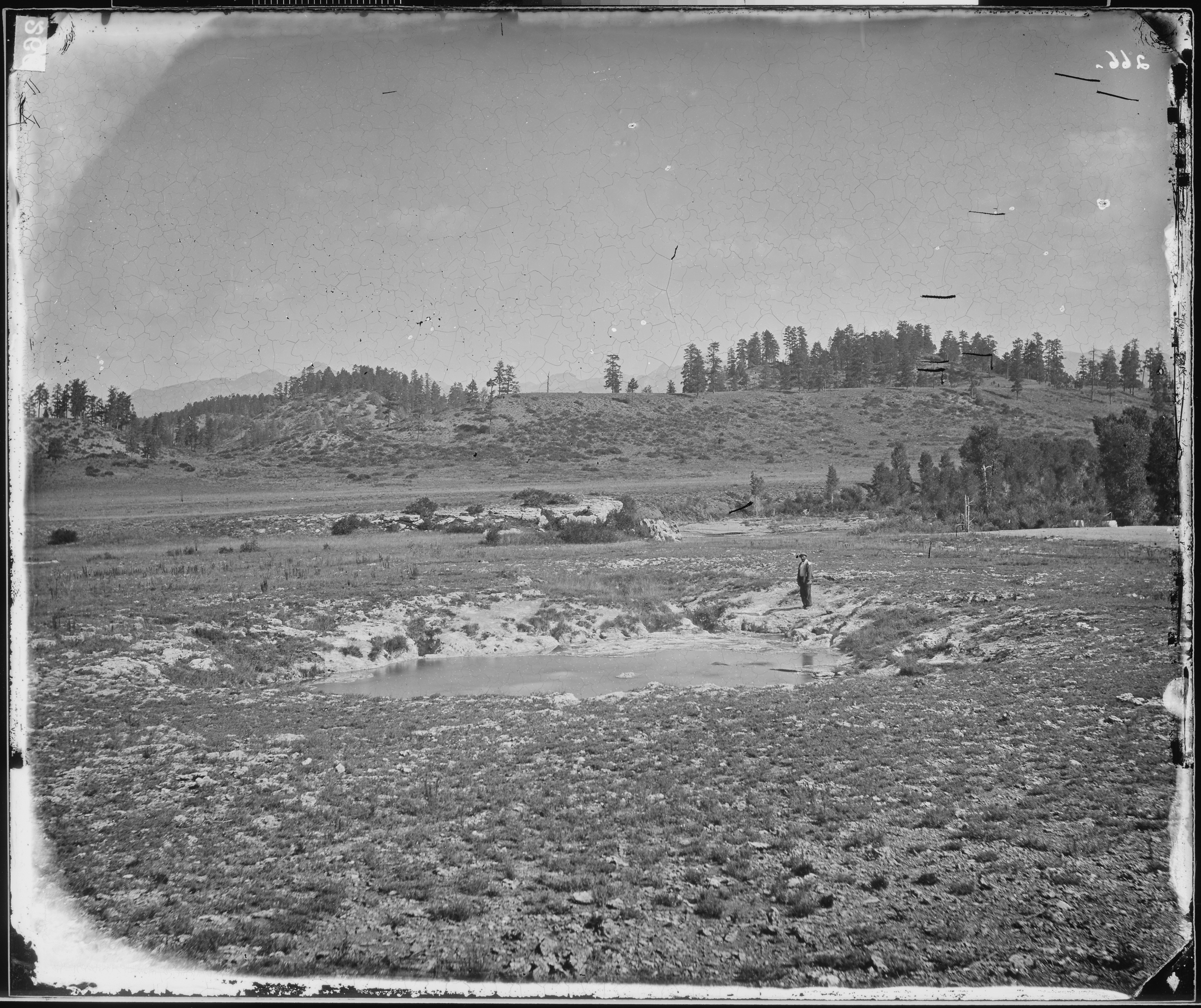
 The hot springs for which Pagosa Springs, Colorado is named, 1874
 The Mother Spring, thermal mineral spring
 Sign for Pagosa Springs
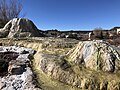 Two of the many hot springs in Pagosa Springs
 Pagosa Springs Museum


See also
- Outline of Colorado
- Index of Colorado-related articles
- State of Colorado
- Colorado cities and towns
- Colorado municipalities
- Colorado counties
- Colorado cities and towns
References
- "Active Colorado Municipalities". State of Colorado, Department of Local Affairs. Archived from the original on 2009-12-12. Retrieved 2007-09-01.
- "Colorado Municipal Incorporations". State of Colorado, Department of Personnel & Administration, Colorado State Archives. 2004-12-01. Retrieved 2007-09-02.
- "2019 U.S. Gazetteer Files". United States Census Bureau. Retrieved July 1, 2020.
- "US Board on Geographic Names". United States Geological Survey. 2007-10-25. Retrieved 2008-01-31.
- "Population and Housing Unit Estimates". United States Census Bureau. May 24, 2020. Retrieved May 27, 2020.
- "ZIP Code Lookup". United States Postal Service. Archived from the original (JavaScript/HTML) on September 3, 2007. Retrieved December 1, 2007.
- "Find a County". National Association of Counties. Retrieved 2011-06-07.
- "Geographic Identifiers: 2010 Demographic Profile Data (G001): Pagosa Springs town, Colorado". U.S. Census Bureau, American Factfinder. Archived from the original on February 12, 2020. Retrieved May 6, 2013.
- "Pagosa Weather | Pagosa Daily Post News Events & Video for Pagosa Springs Colorado".
- "Colorado claims deepest geothermal hot spring record | Guinness World Records". 14 September 2011.
- "Pagosa Springs Harnesses Geothermal Energy for More Than Hot Springs". Visit Pagosa Springs. Retrieved 30 August 2021.
- O'Bryan, Aileen (1956). The Dîné: Origin Myths of the Navaho Indians. Smithsonian Bureau of American Ethnology; Bulletin 163. pp. 12, n. 44. Retrieved 29 January 2022.
- Retzler, Kathryn (2005). "Pagosa Springs - Healing Waters". San Juan Silver Stage; San Juan Publishing Group.
- "EDITORIAL: Taking the Heat, Part Two | Pagosa Daily Post News Events & Video for Pagosa Springs Colorado".
- Vance, Norm; Terry, Kate (18 May 2020). "Dr. Mary Fisher: Pagosa's Historic Heroine". Pagosa Springs Journal.
- "About the Pagosa Springs Medical Center". Pagosa Springs Medical Center. Retrieved 23 November 2021.
- "San Juan River at Pagosa Springs, Colorado". National Water Information System. USGS. Retrieved 30 August 2021.
- "Census of Population and Housing". Census.gov. Retrieved June 4, 2015.
- "U.S. Census website". United States Census Bureau. Retrieved 2008-01-31.
- "2020 CENSUS - SCHOOL DISTRICT REFERENCE MAP: Archuleta County, CO" (PDF). U.S. Census Bureau. Retrieved 2022-07-12.
- "C.W. McCall – Wolf Creek Pass Lyrics | Genius Lyrics".
External links
- Visit Pagosa Springs, The official website for Pagosa Springs visitor information
- Town of Pagosa Springs, The official website for The Town of Pagosa Springs
- The Pagosa Springs Journal, daily news
- Pagosa.com, commercial site
- Pagosa Springs Community Development Corporation
- Archuleta School District #50 JT
Municipalities and communities of Archuleta County, Colorado, United States | ||
|---|---|---|
County seat: Pagosa Springs | ||
| Town |  | |
| CDP | ||
| Unincorporated communities | ||
| Indian reservation |
| |
| Footnotes | ‡This populated place also has portions in an adjacent county or counties | |
| ||
Denver (capital) | ||
| Topics |
|  |
| Society |
| |
| Cities |
| |
| Counties |
| |
| Regions |
| |
Authority control | |
|---|---|
| General | |
| National libraries | |
| Other | |
На других языках
[de] Pagosa Springs
Pagosa Springs ist eine Stadt im Archuleta County im US-Bundesstaat Colorado der Vereinigten Staaten mit 1727 Einwohnern (Stand: 2010) und Sitz der County-Verwaltung. Die geographischen Koordinaten sind 39,91° Nord, 104,98° West. Das Einzugsgebiet der Stadt beträgt 11,4 km².- [en] Pagosa Springs, Colorado
Другой контент может иметь иную лицензию. Перед использованием материалов сайта WikiSort.org внимательно изучите правила лицензирования конкретных элементов наполнения сайта.
WikiSort.org - проект по пересортировке и дополнению контента Википедии