world.wikisort.org - USA
Hoehne is an unincorporated town, a post office, and a census-designated place (CDP) located in and governed by Las Animas County, Colorado, United States. The Hoehne post office has the ZIP Code 81046 (post office boxes).[3] At the United States Census 2010, the population of the Hoehne CDP was 111.[4]
Hoehne, Colorado | |
|---|---|
Census Designated Place | |
 County Road 40.6 in Hoehne. | |
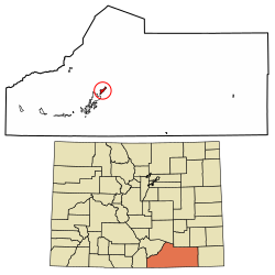 Location of the Hoehne CDP in Las Animas County, Colorado. | |
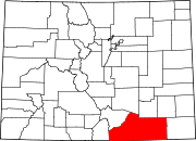
 Hoehne Location of the Hoehne CDP in the United States. | |
| Coordinates: 37°16′53″N 104°23′21″W[1] | |
| Country | |
| State | |
| County | Las Animas County |
| Founded | 1859 |
| Government | |
| • Type | unincorporated town |
| Area | |
| • Total | 3.107 sq mi (8.046 km2) |
| • Land | 3.107 sq mi (8.046 km2) |
| • Water | 0.000 sq mi (0.000 km2) |
| Elevation | 5,738 ft (1,749 m) |
| Population (2010) | |
| • Total | 111 |
| • Density | 36/sq mi (14/km2) |
| Time zone | UTC-7 (MST) |
| • Summer (DST) | UTC-6 (MDT) |
| ZIP Code[3] | 81046 |
| Area code(s) | 719 |
| GNIS feature[2] | Hoehne CDP |
History
Hoehne was founded by German immigrant William Hoehne in 1859 in what was then the Territory of New Mexico. He is credited with founding the Hoehne Ditch Company and introducing the first mill and threshing machine into the area.[5] William Hoehne farmed 1,000 acres (400 ha), planting strawberries, apples, and cherries. Hoehne is still a farming community, but the focus has shifted from fruits to alfalfa and grass hay.
The population of Hoehne today is slightly more than 100 people. But during its heyday, the town boasted a hotel, a train depot called "Hoehnes", a blacksmith, a Catholic church, and several stores. The train depot was retired in 1967 and was moved twice - the second time to its current location in Texas Creek, where it was restored to its original condition.[6] The Hoehnes train depot sign is still visible today at the original depot location.
Hoehne is located near the Santa Fe Trail, and a historical marker is located approximately one mile north of the town on County Road 42.0.
Geography
Hoehne is located in west-central Las Animas County on high ground north of the Purgatoire River. It is 11 miles (18 km) northeast of Trinidad, the county seat.
The Hoehne CDP has an area of 1,988 acres (8.046 km2), all land.[1]
Demographics
The United States Census Bureau initially defined the Hoehne CDP for the United States Census 2010.
| Year | Pop. | ±% |
|---|---|---|
| 2010 | 111 | — |
| 2020 | — | |
| Source: United States Census Bureau | ||
Notable residents
- Ventura Tenario, known as Chief Little Wolf, professional wrestler in USA, Australia, and New Zealand.
See also
- Outline of Colorado
- Index of Colorado-related articles
- State of Colorado
- Colorado cities and towns
- Colorado census designated places
- Colorado counties
- Colorado cities and towns
References
- "State of Colorado Census Designated Places - BAS20 - Data as of January 1, 2020". United States Census Bureau. Retrieved December 23, 2020.
- "U.S. Board on Geographic Names: Domestic Names". United States Geological Survey. Retrieved December 23, 2020.
- "Look Up a ZIP Code". United States Postal Service. Retrieved December 23, 2020.
- "2010: DEC Summary File 1". United States Census Bureau. Retrieved December 23, 2020.
- MacArthur, Mildred Sherwood. A History of the German element in the state of Colorado. Cornell University, 1914, p.24.
- Werkema, Evan. "Santa Fe Surviving Depots: Colorado". Last revised October 4, 2004.
External links
 Definitions from Wiktionary
 Media from Commons
 News from Wikinews
 Quotations from Wikiquote
 Texts from Wikisource
 Textbooks from Wikibooks
 Resources from Wikiversity
Municipalities and communities of Las Animas County, Colorado, United States | ||
|---|---|---|
County seat: Trinidad | ||
| City |
|  |
| Towns | ||
| CDPs | ||
| Unincorporated communities | ||
| Ghost towns | ||
| ||
Другой контент может иметь иную лицензию. Перед использованием материалов сайта WikiSort.org внимательно изучите правила лицензирования конкретных элементов наполнения сайта.
WikiSort.org - проект по пересортировке и дополнению контента Википедии