world.wikisort.org - USA
Weston is an unincorporated town, a post office, and a census-designated place (CDP) located in and governed by Las Animas County, Colorado, United States. The Weston post office has the ZIP Code 81091.[3] At the United States Census 2010, the population of the Weston CDP was 55, while the population of the 81091 ZIP Code Tabulation Area was 812 including adjacent areas.[4]
Weston, Colorado | |
|---|---|
Census Designated Place | |
 Weston Supply and U.S. Post Office in Weston. | |
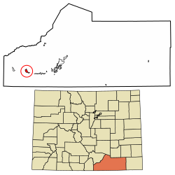 Location of the Weston CDP in Las Animas County, Colorado. | |
 Weston Location of the Weston CDP in the United States. | |
| Coordinates: 37°08′45″N 104°52′06″W[1] | |
| Country | |
| State | |
| County | Las Animas County |
| Government | |
| • Type | unincorporated town |
| Area | |
| • Total | 3.099 sq mi (8.026 km2) |
| • Land | 3.099 sq mi (8.026 km2) |
| • Water | 0.000 sq mi (0.000 km2) |
| Elevation | 7,054 ft (2,150 m) |
| Population (2010) | |
| • Total | 55 |
| • Density | 18/sq mi (7/km2) |
| Time zone | UTC-7 (MST) |
| • Summer (DST) | UTC-6 (MDT) |
| ZIP Code[3] | 81091 |
| Area code | 719 |
| GNIS feature[2] | Weston CDP |
History
The Weston Post Office has been in operation since 1889.[5] The community was named after A. J. Weston, a local pioneer.[6]
There is an old church at Vigil Plaza, near Weston.
There is a different old church dating from 1866 or 1867, and a cemetery, about three miles east, at Medina Plaza. These were listed on the National Register of Historic Places in 2019 as Our Lady of Guadalupe Church and Medina Cemetery.
Geography
Weston sits in the valley of the Purgatoire River, on the north side of the river, near where the South Fork joins the main stem. Colorado State Highway 12 passes through the community, leading east (downriver) 22 miles (35 km) to Trinidad, the county seat, and west 11 miles (18 km) to Stonewall Gap.
The Weston CDP has an area of 1,983 acres (8.026 km2), all land.[1]
Demographics
The United States Census Bureau initially defined the Weston CDP for the United States Census 2010.
| Year | Pop. | ±% |
|---|---|---|
| 2010 | 55 | — |
| 2020 | — | |
| Source: United States Census Bureau | ||
See also
- Outline of Colorado
- Index of Colorado-related articles
- State of Colorado
- Colorado cities and towns
- Colorado census designated places
- Colorado counties
- Colorado cities and towns
References
- "State of Colorado Census Designated Places - BAS20 - Data as of January 1, 2020". United States Census Bureau. Retrieved December 23, 2020.
- "U.S. Board on Geographic Names: Domestic Names". United States Geological Survey. Retrieved December 23, 2020.
- "Look Up a ZIP Code". United States Postal Service. Retrieved December 23, 2020.
- "2010: DEC Summary File 1". United States Census Bureau. Retrieved December 23, 2020.
- "Post offices". Jim Forte Postal History. Retrieved 11 July 2016.
- Dawson, John Frank. Place Names in Colorado: Why 700 Communities Were So Named, 150 of Spanish or Indian Origin. Denver, CO: The J. Frank Dawson Publishing Co. p. 51.
External links
 Definitions from Wiktionary
 Media from Commons
 News from Wikinews
 Quotations from Wikiquote
 Texts from Wikisource
 Textbooks from Wikibooks
 Resources from Wikiversity
- Weston @ Colorado.com
- Weston @ UncoverColorado.com
- Weston @ SouthernColorado.info
- Las Animas County website
Municipalities and communities of Las Animas County, Colorado, United States | ||
|---|---|---|
County seat: Trinidad | ||
| City | 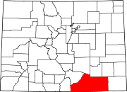 | |
| Towns | ||
| CDPs | ||
| Unincorporated communities | ||
| Ghost towns | ||
| ||
Другой контент может иметь иную лицензию. Перед использованием материалов сайта WikiSort.org внимательно изучите правила лицензирования конкретных элементов наполнения сайта.
WikiSort.org - проект по пересортировке и дополнению контента Википедии