world.wikisort.org - Japan
Hachijō (八丈町, Hachijō-machi) is a town located in Hachijō Subprefecture, Tokyo Metropolis, Japan. As of 1 June 2016[update], the town had an estimated population of 7,516, and a population density of 104 persons per km². Its total area is 72.23 square kilometres (27.89 sq mi). Electric power for the town is provided by a geothermal power station and by a wind farm.
This article needs additional citations for verification. (September 2016) |
Hachijō
八丈町 | |
|---|---|
Town | |
 Hachijōjima as viewed from Noboryu peak | |
 Flag  Seal | |
 Location of Hachijō in Tokyo Metropolis | |
 Hachijō | |
| Coordinates: 33°06′34.2″N 139°47′27.2″E | |
| Country | Japan |
| Region | Kantō |
| Prefecture | Tokyo Metropolis |
| First official recorded | 1156 AD |
| Town settled | April 1, 1955 |
| Government | |
| • Mayor | Tomonari Yamashita (from November 2011) |
| Area | |
| • Total | 72.23 km2 (27.89 sq mi) |
| Population (June 2016) | |
| • Total | 7,516 |
| • Density | 104/km2 (270/sq mi) |
| Time zone | UTC+9 (Japan Standard Time) |
| Phone number | 04996-2-1121 |
| Address | 2345-1, Ōkagō, Hachijō-machi, Tōkyō-to 100-1498 |
| Climate | Cfa |
| Website | www |
| Symbols | |
| Bird | Izu thrush |
| Fish | Flying fish |
| Flower | Strelitzia |
| Tree | Pygmy date palm |
Geography
Hachijō covers the islands of Hachijō-jima and Hachijō-kojima, two of the islands in the Izu archipelago in the Philippine Sea, 228 kilometres (142 mi) south of central Tokyo. Warmed by the Kuroshio Current, the town has a warmer and wetter climate than central Tokyo. All of the town's residents live on the island of Hachijō-jima.
Neighboring municipalities
- Tokyo Metropolis
Population
The population of Hachijō as of 2015[update] was 7613.[1]
 | |||||||||||||||||||||||||||||||
| Comparison of Population Distribution between Hachijō-jima and Japanese National Average | Population Distribution by Age and Sex in Hachijō-jima | ||||||||||||||||||||||||||||||
■Hachijō-jima ■Japan (average) |
■Male ■Female | ||||||||||||||||||||||||||||||
| |||||||||||||||||||||||||||||||
| 2015 Census, Ministry of Internal Affairs and Communications - Statistics Department | |||||||||||||||||||||||||||||||
Climate
| Climate data for Hachijō-jima (1991−2020 normals, extremes 1906−present) | |||||||||||||
|---|---|---|---|---|---|---|---|---|---|---|---|---|---|
| Month | Jan | Feb | Mar | Apr | May | Jun | Jul | Aug | Sep | Oct | Nov | Dec | Year |
| Record high °C (°F) | 21.5 (70.7) |
21.9 (71.4) |
22.7 (72.9) |
26.3 (79.3) |
27.4 (81.3) |
30.4 (86.7) |
34.2 (93.6) |
34.8 (94.6) |
33.2 (91.8) |
31.0 (87.8) |
26.3 (79.3) |
24.6 (76.3) |
34.8 (94.6) |
| Average high °C (°F) | 12.9 (55.2) |
13.5 (56.3) |
15.8 (60.4) |
18.9 (66.0) |
21.8 (71.2) |
24.1 (75.4) |
27.7 (81.9) |
29.6 (85.3) |
27.6 (81.7) |
23.8 (74.8) |
20.0 (68.0) |
15.6 (60.1) |
20.9 (69.6) |
| Daily mean °C (°F) | 10.1 (50.2) |
10.4 (50.7) |
12.5 (54.5) |
15.8 (60.4) |
18.8 (65.8) |
21.3 (70.3) |
25.2 (77.4) |
26.5 (79.7) |
24.5 (76.1) |
21.0 (69.8) |
16.9 (62.4) |
12.7 (54.9) |
18.0 (64.4) |
| Average low °C (°F) | 7.6 (45.7) |
7.5 (45.5) |
9.3 (48.7) |
12.9 (55.2) |
16.2 (61.2) |
19.4 (66.9) |
23.3 (73.9) |
24.3 (75.7) |
22.3 (72.1) |
18.7 (65.7) |
14.2 (57.6) |
9.9 (49.8) |
15.5 (59.9) |
| Record low °C (°F) | −1.8 (28.8) |
−2.0 (28.4) |
0.0 (32.0) |
4.5 (40.1) |
8.3 (46.9) |
11.5 (52.7) |
15.6 (60.1) |
16.7 (62.1) |
14.7 (58.5) |
10.4 (50.7) |
5.9 (42.6) |
0.3 (32.5) |
−2.0 (28.4) |
| Average precipitation mm (inches) | 201.7 (7.94) |
205.5 (8.09) |
296.5 (11.67) |
215.2 (8.47) |
256.7 (10.11) |
390.3 (15.37) |
254.1 (10.00) |
169.5 (6.67) |
360.5 (14.19) |
479.1 (18.86) |
277.4 (10.92) |
200.2 (7.88) |
3,306.7 (130.17) |
| Average rainy days | 14.1 | 13.7 | 16.3 | 12.9 | 12.7 | 15.3 | 10.5 | 10.8 | 15.0 | 16.5 | 14.0 | 14.3 | 166.1 |
| Average relative humidity (%) | 68 | 69 | 71 | 77 | 84 | 91 | 92 | 87 | 86 | 82 | 74 | 69 | 79 |
| Mean monthly sunshine hours | 84.9 | 87.8 | 124.5 | 139.4 | 148.5 | 87.1 | 137.3 | 185.9 | 139.6 | 107.1 | 102.6 | 100.4 | 1,445.1 |
| Source 1: JMA[2] | |||||||||||||
| Source 2: JMA[3] | |||||||||||||
History
During the Edo period, Hachijōjima was known as a place of exile for convicts. This practice ended in the Meiji period, and the island residents developed an economy based on fishing, sericulture, and agriculture. Hachijō Subprefecture was organized on April 1, 1908, and included the villages of Mitsune, Nakanogo, Kashitate, Sueyoshi and Ōkago. The villages of Toruchi and Utsuki on Hachijōkojima were organized on May 3, 1947. The five villages of Hachijōjima merged on October 1, 1954 to form the village of Hachijō. On April 1, 1955, the two villages of Hachijōkojima also merged with the village of Hachijō, which was promoted to town status. However, in March 1966, the residents of Hachijōkojima voted to abandon their island, citing the inaccessibility of basic public services and economic difficulties, and Hachijōkojima became a deserted island from June 1969.
Economy
Fishing and tourism are the mainstays of the economy of Hachijō.
Education
The town government operates three public elementary and three public junior high schools.[4]
Junior high schools:
- Fuji Junior High School (富士中学校)
- Mihara Junior High School (三原中学校)
- Okago Junior High School (大賀郷中学校)
Elementary schools:
- Mihara Elementary School (三原小学校)
- Mitsune Elementary School (三根小学校)
- Okago Elementary School (大賀郷小学校)
The Tōkyō Metropolitan Government Board of Education operates Hachijō High School.[5]
Transportation
Hachijōjima is accessible both by aircraft and by ferry. A pedestrian ferry leaves Tōkyō once every day at 10 p.m., and arrives at Hachijōjima at 9:00 a.m. the following day. Air travel to Hachijojima Airport takes 45 minutes from Tōkyō International Airport (Haneda).
Sister city relations
 - Maui County, Hawaii, United States
Gallery
 Hachijōjima (right) and Hachijōkojima (left)
 typical stone walls
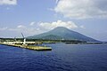 Sokodo Harbor


See also
- Runin: Banished, a 2004 film about convicts exiled to Hachijōjima, and their attempts to escape.
- Battle Royale, a controversial 2000 film filmed on the neighbouring, uninhabited island, Hachijō-kojima, although not set there.
References
- 人口 八丈町 (PDF) (in Japanese). Hachijō. March 1, 2018. Archived (PDF) from the original on April 13, 2018. Retrieved March 14, 2018.
- 観測史上1~10位の値(年間を通じての値). JMA. Retrieved February 17, 2022.
- 気象庁 / 平年値(年・月ごとの値). JMA. Retrieved February 17, 2022.
- "教育課からのお知らせ" (in Japanese). Hachijo. Retrieved 2022-11-05.
- 東京都立八丈高等学校 [Tokyo Tōritsu Hachijō High School] (in Japanese). 東京都教育委員会 (Tokyo Metropolitan Board of Education). Archived from the original on March 9, 2018. Retrieved March 8, 2018.
External links
- Hachijō Town Official Website (in Japanese)
- The Anchor Pub in Hachijō Town
Authority control | |
|---|---|
| General | |
| National libraries | |
| Scientific databases | |
| Other |
|
На других языках
- [en] Hachijō, Tokyo
[es] Hachijō (Tokio)
Hachijō (八丈町, Hachijō-machi?) es un pueblo que se encuentra en Tokio, Japón; específicamente en la zona de las islas Izu.[fr] Hachijō
Hachijō (八丈町, Hachijō-machi?) est un bourg de la sous-préfecture de Hachijō, dans la préfecture de Tokyo au Japon.[it] Hachijō
Hachijō (八丈町?) è una cittadina giapponese facente parte dell'omonima Sottoprefettura di Hachijō, il cui territorio ricade sotto la giurisdizione del Governo Metropolitano di Tokyo.[ru] Хатидзё (посёлок)
Хатидзё (яп. 八丈町 Хатидзё:-мати) — посёлок в Японии, находящийся в округе Хатидзё префектуры Токио. Площадь посёлка составляет 72,62 км²[1], население — 7048 человек (1 октября 2020)[2], плотность населения — 97,05 чел./км².Другой контент может иметь иную лицензию. Перед использованием материалов сайта WikiSort.org внимательно изучите правила лицензирования конкретных элементов наполнения сайта.
WikiSort.org - проект по пересортировке и дополнению контента Википедии