world.wikisort.org - India
Bardhaman (/ˈbɔːrdəˌmɑːn/, Bengali: [ˈbɔrˌd̪ʱo.man]) is a city and a municipality in the state of West Bengal, India. It is the headquarters of Purba Bardhaman district, having become a district capital during the period of British rule. Burdwan, an alternative name for the city, has remained in use since then.
Bardhaman
Burdwan | |
|---|---|
City | |
 Burdwan City at night | |
| Nickname: Royal Heritage City of West Bengal | |
 Bardhaman  Bardhaman  Bardhaman | |
| Coordinates: 23°14′N 87°52′E | |
| Country | |
| State | |
| District | Purba Bardhaman |
| Government | |
| • Type | Municipality |
| • Body |
|
| • Chairman | Paresh Chandra Sarkar[1] |
| • Vidhan Sabha MLA | No. 260 Bardhaman Dakshin: Khokan Das (AITC) |
| • Lok Sabha MP | No. 39 Bardhaman–Durgapur: S. S. Ahluwalia (BJP) |
| Area | |
| • City | 26.30 km2 (10.15 sq mi) |
| • Metro | 157.62 km2 (60.86 sq mi) |
| Elevation | 30 m (100 ft) |
| Population (2011)[4] | |
| • City | 347,016 |
| • Density | 13,000/km2 (34,000/sq mi) |
| • Metro | 407,000 |
| Languages | |
| • Official | Bengali[5][6] |
| • Additional official | English[6] |
| Time zone | UTC+5:30 (IST) |
| PIN | 713101, 713102, 713103, 713104 713141,713149. |
| Telephone code | +91-342 |
| Vehicle registration | WB-42 |
| Website | burdwanmunicipality |
Etymology
The history of Burdwan is known from about 5000 BC (the Mesolithic or Late Stone Age).[citation needed] The origin of this name dates back to the sixth century BCE and is ascribed to Vardhamāna or Mahāvīra (599-527 BCE), the 24th Tīrthāṅkara of Jainism, who spent some time in Astikagrama, according to the Jain scripture of Kalpa Sūtra. This place was renamed as Vardhamana in his honour.
History
During the period of Jahangir this place was named Badh-e-dewan (district capital). The city owes its historical importance to being the headquarters of the Maharajas of Burdwan, the premier noblemen of lower Bengal, whose rent-roll was upwards of 300,000. Bardhaman Raj was founded in 1657 by Sangam Rai, of a Hindu Khatri family of Kotli in Lahore, Punjab, whose descendants served in turn the Mughal Emperors and the British government. The East Indian Railway from Howrah was opened in 1855. The great prosperity of the raj was due to the excellent management of Maharaja Mahtab Chand (died 1879), whose loyalty to the government especially during the "Hul" (Santhal rebellion) of 1855-56 and the Indian rebellion of 1857 was rewarded with the grant of a coat of arms in 1868 and the right to a personal salute of 13 guns in 1877. Maharaja Bijaychand Mahtab (born 1881), who succeeded his adoptive father in 1888, earned great distinction by the courage with which he risked his life to save that of Sir Andrew Fraser, the lieutenant-governor of Bengal, on the occasion of the attempt to assassinate him made by freedom fighters of Bengal on 7 November 1908.[7]
Mahtab Chand Bahadur and later Bijoy Chand Mahtab struggled their best to make this region culturally, economically and ecologically healthier. The chief educational institution was the Burdwan Raj College, which was entirely supported out of the maharaja's estate. Sadhak Kamalakanta as composer of devotional songs and Kashiram Das as a poet and translator of the great Mahabharata were possibly the best products of such an endeavour. Pratap Chandra Roy was the publisher of the first translation in the world to translate Mahabharata in English (1883–1896).[8] The society at large also continued to gain the fruits. We find, among others, the great rebel poet Kazi Nazrul Islam and Kala-azar-famed U. N. Brahmachari as the relatively recent illustrious sons of this soil. Batukeshwar Dutt an Indian revolutionary and independence fighter in the early 1900s was born on 18 November 1910 in a village Oari in Burdwan district. He is best known for having exploded a few bombs, along with Bhagat Singh, in the Central Legislative Assembly in New Delhi on 8 April 1929. The city became an important centre of North-Indian classical music as well.
Geography
R: temple, mosque, P: park, F: facility, C: university, college, museum, H: historical site
Owing to space constraints in the small map, the actual locations in a larger map may vary slightly
Location
The region has an average elevation of 40 metres (131 ft). The city is situated 1100 km from New Delhi and a little less than 100 km north-west of Kolkata on the Grand Trunk Road (National Highway 19) and Eastern Railway. The chief rivers are the Damodar and the Banka.[9]
The first epigraphic reference to the name of this place occurs in a sixth-century AD copper plate found in Mallasarul village under Galsi Police Station. Archeological evidences suggest that this region, forming a major part of Radh Bengal, could be traced even back to 4000 BCE.

Police stations
Burdwan police station has jurisdiction over Bardhaman municipal area and Burdwan I and Burdwan II CD Blocks. The area covered is 192.15 km2. There are out posts at Barabazar, Muradpur, Keshabganj, Nutanganj and Birhata.2[10][11]
Women police station Burdwan has jurisdiction over Bardhaman municipal area and Burdwan I and Burdwan II CD Blocks. The area covered is 192.15 km.[10][11]
Demographics
| Year | Pop. | ±% |
|---|---|---|
| 1951 | 76,000 | — |
| 1961 | 109,000 | +43.4% |
| 1971 | 144,000 | +32.1% |
| 1981 | 170,000 | +18.1% |
| 1991 | 246,000 | +44.7% |
| 2001 | 287,000 | +16.7% |
| 2011 | 347,016 | +20.9% |
| Source: [13] | ||
In the 2011 census, Bardhaman Urban Agglomeration had a population of 347,016, out of which 177,055 were males and 169,961 were females. 25,069 people were between the ages of 0–6 years. Effective literacy rate for the 7+ population was 88.62%.[4]
Climate
The Köppen Climate Classification sub-type for this climate is "Aw" (tropical savanna climate).
| Climate data for Burdwan, India | |||||||||||||
|---|---|---|---|---|---|---|---|---|---|---|---|---|---|
| Month | Jan | Feb | Mar | Apr | May | Jun | Jul | Aug | Sep | Oct | Nov | Dec | Year |
| Average high °C (°F) | 26.0 (78.8) |
27.5 (81.5) |
34.5 (94.1) |
37.4 (99.4) |
32.6 (90.7) |
34.9 (94.9) |
32 (90) |
32.3 (90.1) |
32.4 (90.3) |
32.0 (89.6) |
28.0 (82.4) |
26.0 (78.8) |
31.32 (88.38) |
| Average low °C (°F) | 12.0 (53.6) |
15 (59) |
20 (68) |
24.9 (76.8) |
25.9 (78.6) |
26.0 (78.8) |
25 (77) |
25 (77) |
25 (77) |
24.7 (76.5) |
17.5 (63.5) |
12.5 (54.5) |
21 (70) |
| Average precipitation mm (inches) | 18 (0.7) |
38 (1.5) |
33 (1.3) |
48 (1.9) |
130 (5) |
240 (9.6) |
350 (13.7) |
310 (12.3) |
290 (11.4) |
160 (6.2) |
28 (1.1) |
5.1 (0.2) |
1,650 (64.9) |
| Average rainy days | 4 | 3 | 4 | 6 | 10 | 18 | 23 | 22 | 18 | 11 | 3 | 1 | 123 |
| Source: Weather2[14] | |||||||||||||
Culture
This section does not cite any sources. (March 2014) |
Burdwan has a multi-cultural heritage. The deuls (temples of rekha type) found here are reminiscent of Bengali Hindu architecture. The old temples bear signs of Hinduism, mostly belonging to the Sakta and Vaishnava followers.
The Kankaleswari Kali is also located in the city of Burdwan. Burdwan experienced and survived numerous violent conflicts, mainly due to Mughal, Pashtun and Maratha invaders. The city of Bardhaman was visited by notables of the Delhi Sultanate from Raja Todarmal to Daud Karnani, from Sher Afghan and Kutub-ud-din to Ajimuswan to the future Mughal emperor Shah Jahan while he was still a rebel. Bardhaman also has a number of Bengali Christians, and although they are a minority, there are many churches in the city.
Foods
- Sitabhog and Mihidana are two famous sweets of Burdwan, introduced first in honour of the Raj family.[citation needed]
- Shaktigarh's langcha is another local speciality for Shaktigarh in the eastern part of Burdwan City.[citation needed]
Transport
Road
- The Grand Trunk Road runs across the city; NH 19 (old numbering NH 2) bypasses the city. South Bengal State Transport Corporation (SBSTC) and private operators operate buses from Arambag, Asansol, Baharampur, Bankura, Bolpur, Esplanade, Kirnahar, Purulia, Saltlake and Tarakeswar. It takes around 2–21⁄2 hours. Bardhaman is well connected by bus with numerous places all around. Most of the buses arrive and leave from Alisha Bus Stand and Nababhat Bus Stand. Burdwan also has a facility of bus service known as Town Service which connects different areas within the city.
- Sadarghat Road also connects Bardhaman with Bankura (indirectly) and Hooghly (directly) district.
Rail
- The main Howrah-Delhi rail track passes through Bardhaman, and the city is served by Bardhaman railway station. The Howrah Rajdhani Express (via Patna) has a scheduled stop at Bardhaman. One can take a local train from Howrah to reach in two hrs. One can also travel along the Sahibganj Loop, which branches off, one station after Bardhaman. The narrow gauge line to Katwa was upgraded to broad gauge in 2013, up to Balgona, which has been extended to Katwa.
Rickshaws
- Cycle rickshaws and E-Rickshaws (Toto) are available for travel within the city.
- Also available mini bus within city and surrounding. Intracity connector by SBSTC under JNNURM project has been provided.
- Ola's bike service is also active in the city.
Education
University
The University of Burdwan was formally inaugurated on 15 June 1960 by Sukumar Sen, its first Vice-chancellor. It was after the abolition of the Zamindari system in the fifties that Uday Chand Mahtab, the last representative of the Burdwan Raj, left almost his entire property in Burdwan to the state government. This, coupled with the initiative of the then Chief Minister of West Bengal, Bidhan Chandra Roy, facilitated the establishment of this university. Presently, the administrative works are mostly done at the Rajbati (the palace of Barddhamana Maharaja) campus; on the other hand, academic activities centre on the Golapbag campus. With social responsibilities in mind, the university actively patronised the construction of a science centre and the Meghnad Saha Planetarium.
Colleges
- Burdwan Dental College and Hospital
- Burdwan Homoeopathic Medical College & Hospital
- Burdwan Medical College
- Burdwan Raj College
- Maharajadhiraj Uday Chand Women's College
- M.B.C. Institute of Engineering and Technology
- University Institute of Technology, Burdwan University
- Vivekananda Mahavidyalaya
- St. Xavier's College, Burdwan
Schools
- Burdwan CMS High School (Main), B. C. Road - West Bengal Board
- Burdwan Municipal Girls' High School - West Bengal Board
- Burdwan Municipal High School - established in 1883 by Debendranath Tagore
- St. Xaviers School - CISCE
- Kendriya Vidyalaya Burdwan - CBSE
Places of interest
 Sarbamangala Temple
 108 Shiva Temple
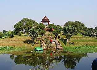 Hawa Mahal (Golapbag)
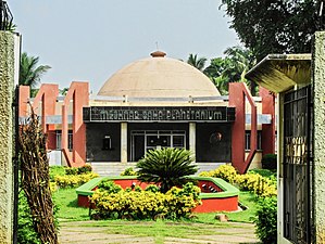 Meghnad Saha Planetarium, Golapbag, Bardhaman
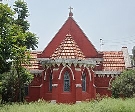 Christ Church
 Damodar River
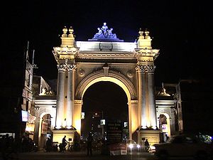 Curzon Gate
 Inside view of the palace of Burdwan Maharaja
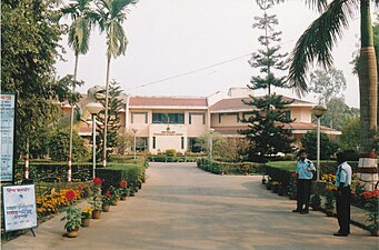 Science Centre
 Maa Kankaleshwari at her temple
 Mazar of Sufi Pir Baharam Sakka
 Damodareshwar Shiva Temple, Damodarpally, Burdwan
 Burdwan Arcade
 Damodar River


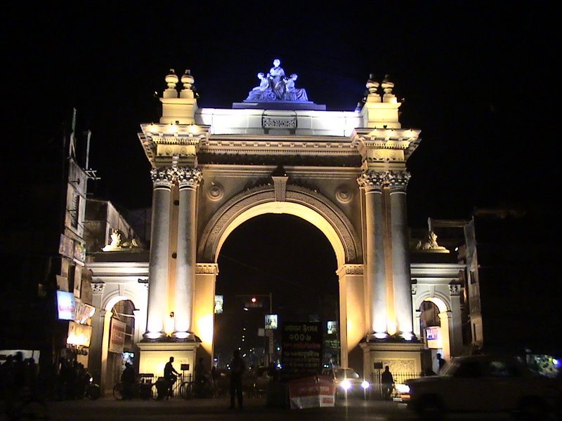


- Curzon Gate – the Curzon Gate was built in 1902–1903, for the coronation of Maharaja Bijay Chand Mahatab. The former royal palace is located a kilometer from the gate.[15][16] The pomp and grandeur of Lord Curzon's visit to Bardhaman in 1904 established the name of the gate as Curzon Gate. It is also known as Bijay Toran.[15][17]
- Tombs of Sher Afgan and Qutbuddin Khan Koka - Mehr-un-Nissa, then wife of Sher Afgan, jagirdar of Bardhaman, was once a resident of Bardhaman. It is said that the Mughal emperor Jahangir had fallen in love with her and was determined to marry her. He tried to get her with the help of his foster-brother and subahdar of Bengal, Qutbuddin Khan Koka. Sher Afgan died during a fight with Qutbuddin Khan Koka, who also was killed. Both were buried side by side at Bardhaman in 1607 (or 1610 according to some sources), in the same place as Pir Baharam Sikka, a Persian Sufi saint. Mehr-un-Nissa ultimately emerged as the Empress Nur Jahan.[18][19]
- Rajbari – the palace of the Bardhaman Raj family, was built by Mahatabchand in the 19th century, at a site that is earlier believed to have a Mughal fort. The Rajbari was built by the Kolkata-based Burn and Company. The main hall has many valuable paintings.[17] Uday Chand Mahtab handed over the Rajbati to the state government. It now houses the administrative offices of the University of Burdwan.[20]
- Golapbag, Ramna Bagan and Deer Park – Golapbag was developed as a botanical and zoological garden in the 19th century. It contained lakes for boating and Hawa Mahal. Several academic sections of the University of Burdwan are located there. Ramna Bagan once had a Brahmo Samaj. It now has a deer park.[17]
- Sarbamangala temple - the temple of Sarbamangala, the presiding deity of the Bardhaman Raj and believed to have been found on the sand-bed of the Damodar River.[19] It is a navaratna temple with a nata mandir that has a terracotta Durga panel.[17]
- Bardhamaneswar Shiva temple - the Shiva temple has a huge idol.[19] Many believe that the Shiva lingam in the temple was established by Chand Sadagar of Manasamangal fame.[17]
- Kamalakanta Kalibari - it is a Kali temple associated with the poet-devotee Sadhak Kamalakanta.[19]
- 108 Shiva temple complex - the Shiva temple complex, constructed by Maharani Bishnu Kumari, at Nawabhat, near Bardhaman, has a picturesque setting.[19] The temple complex, built in 1788, fell into disrepairs and was thoroughly renovated by the Birla Public Welfare Trust.[17]
- Kankaleshwari Mandir – the temple at Kanchanagar, has a deity resembling a human skeleton.[19] It is a navaratna temple with terracotta carvings. The idol is that of a six feet tall eight armed goddess Chamunda.[17]
- Tomb of Khwaja Anwar Berh - the tomb of the Mughal warrior, buried at Poddarhat in 1315 Hijri, is a fine example of Mughal architecture.[17][19]
- Shershahi Kalo Masjid- the mosque in the Puratan Chak (Payrakhana Road) area was built during the reign of Sher Shah Suri.[17]
- Shahi Jumma Masjid- the mosque with three minarets is a historical structure erected behind the Rajbati by Azim-ush-Shan, grandson of Aurangzeb and then subahdar of Bengal, Bihar and Odisha.[17][19]
- Burdwan Science Centre- a high standard science museum near the university campus.[19]
- Meghnad Saha Planetarium- inaugurated in 1994, the main instrument was a gift from the Government of Japan to the University of Burdwan. The second planetarium in the state, built to international standards, it is named after the Indian scientist Meghnad Saha. Located near Golapbag, it has arrangement for six shows daily with 90 seats in each show. It is closed on Mondays.[17][19]
- Birhata Kalibari (Boro Maa): The temple of 10 feet sculpture of goddess Kali made up of touchstone. The goddess is known locally as Boro Maa. The locality had been named after this temple as Kali Bazar. The temple has two parts bisected by a lane. One part contains Kali Mandir and the other, Durga Mandir.
- Christ Church: Christ Church Bardhaman is a very church in Bardhaman near "Curzon Gate".
- Town Hall : The Town Hall was built sometime between 1890 and 1894 and was handed to the Municipality of Bardhaman to help them preserve the remnants of Lala Bansogopal Nandey.[21] The municipality board restored the hall in 1990 to its present form of 2400 square feet from its earlier form of 704 square feet with a seating capacity of 485 seats.[22]
References
- "Burdwan Municipality". www.burdwanmunicipality.gov.in. Retrieved 30 December 2020.
- "Burdwan Municipality - Area of Populations". burdwanmunicipality.gov.in. Retrieved 24 November 2020.
- "Burdwan Development Authority". www.bdaburdwan.org. Retrieved 1 February 2021.
- "Urban Agglomerations/Cities having population 1 lakh and above" (PDF). Provisional Population Totals, Census of India 2011. Retrieved 21 October 2011.
- "52nd Report of the Commissioner for Linguistic Minorities in India" (PDF). Nclm.nic.in. Ministry of Minority Affairs. p. 85. Archived from the original (PDF) on 25 May 2017. Retrieved 28 August 2019.
- "Fact and Figures". Wb.gov.in. Retrieved 28 August 2019.
- One or more of the preceding sentences incorporates text from a publication now in the public domain: Chisholm, Hugh, ed. (1911). "Burdwan". Encyclopædia Britannica. Vol. 4 (11th ed.). Cambridge University Press. p. 811.
- Kisari Mohan Ganguli tr. (1883). "Translator's Preface". The Mahabharata Book 1: Adi Parva. p. xii.
- "Maps, Weather, and Airports for Barddhaman, India". fallingrain.com. Retrieved 25 July 2016.
- "District Statistical Handbook 2014 Bardhaman". Tables 2.1, 2.2. Department of Statistics and Programme Implementation, Government of West Bengal. Archived from the original on 21 January 2019. Retrieved 23 September 2018.
- "Purba Bardhaman District Police". Police Station. West Bengal Police. Archived from the original on 27 September 2018. Retrieved 23 September 2018.
- "C-1 Population By Religious Community - Bardhaman (M)". Retrieved 17 August 2020.
- "Barddhaman, India Metro Area Population 1950-2020".
- "Weather2". Weather2. 2013. Retrieved on 6 October 2013.
- "Census of India 2011: District Census Handbook, Barddhaman, Series-20, Part-XIIB" (PDF). Motif. Diretorate of Census Operations, West Bengal. Retrieved 10 March 2017.
- "Curzon Gate, Bardhaman". Weekend Destinations. Holidify. Retrieved 10 March 2017.
- Chattopadhyay, Akkori, Bardhaman Jelar Itihas O Lok Sanskriti (History and Folk lore of Bardhaman District.), (in Bengali), Vol II, pages 565-576, Radical Impression. ISBN 81-85459-36-3
- Ghosh, Binoy, Paschim Banger Sanskriti, (in Bengali), part I, 1976 edition, pages 103-104, Prakash Bhaban
- "Purba Bardhaman district". Tourism. District Administration. Retrieved 12 February 2019.
- "The University of Burdwan". History of Burdwan University. BU. Retrieved 3 March 2019.
- "Burdwan Municipality". Retrieved 11 April 2021.
- "Town Hall, Bardhaman". Trawel. Retrieved 11 April 2021.
External links
- Burdwan Town, The Imperial Gazetteer of India, 1909, v. 9, p. 102.
- Official website of Bardhaman District
- Official website of MGNREGS Cell, Bardhaman District
- Bardhaman Utsav (Annual cultural programme of Bardhaman)
- Bardhaman Municipality
- Bardhaman darshan (Official tourism website)
Cities, towns and locations in Purba Bardhaman district, Burdwan division | ||||||||||
|---|---|---|---|---|---|---|---|---|---|---|
| Cities, municipal and census towns |
|  | ||||||||
| Locations other than cities and towns |
| |||||||||
| Related topics |
| |||||||||
На других языках
[de] Bardhaman
Bardhaman (auch Barddhaman; Bengalisch: .mw-parser-output .Beng{font-size:110%}বর্ধমান, Bardhamān; früher engl. Burdwan) ist eine Stadt im indischen Bundesstaat Westbengalen. Sie hat etwa 330.000 Einwohner und ist Verwaltungssitz des Distrikts Bardhaman.- [en] Bardhaman
[ru] Бардхаман
Ба́рдхаман (англ. Bardhaman), или Бурдван (англ. Burdwan) — город в индийском штате Западная Бенгалия. Административный центр округа Бардхаман. Средняя высота над уровнем моря — 39 метров. Расположен в 1100 км от Дели и в менее чем 100 км к северо-западу от Калькутты. По данным всеиндийской переписи 2011 года, в городе проживало 347 016 человек[1].Другой контент может иметь иную лицензию. Перед использованием материалов сайта WikiSort.org внимательно изучите правила лицензирования конкретных элементов наполнения сайта.
WikiSort.org - проект по пересортировке и дополнению контента Википедии