world.wikisort.org - India
Jukhia is a village and a gram panchayat in the Bhagabanpur II CD block in the Contai subdivision of the Purba Medinipur district in the state of West Bengal, India.
Jukhia | |
|---|---|
Village | |
 Jukhia Location in West Bengal, India  Jukhia Jukhia (India) | |
| Coordinates: 21.982713°N 87.764136°E | |
| Country | |
| State | West Bengal |
| District | Purba Medinipur |
| Population (2011) | |
| • Total | 4,291 |
| Languages | |
| • Official | Bengali, English |
| Time zone | UTC+5:30 (IST) |
| PIN | 721430 |
| Telephone/STD code | 03228 |
| Lok Sabha constituency | Kanthi |
| Vidhan Sabha constituency | Bhagabanpur |
| Website | purbamedinipur |
Geography
M: municipal city/ town, CT: census town, R: rural/ urban centre, H: historical/ religious centre, S: port, sea-beach
Owing to space constraints in the small map, the actual locations in a larger map may vary slightly
Location
Jukhia is located at 21.982713°N 87.764136°E.
Urbanisation
93.55% of the population of Contai subdivision live in the rural areas. Only 6.45% of the population live in the urban areas and it is considerably behind Haldia subdivision in urbanization, where 20.81% of the population live in urban areas.[1]
Note: The map alongside presents some of the notable locations in the subdivision. All places marked in the map are linked in the larger full screen map.
Demographics
According to the 2011 Census of India, Jukhia had a total population of 4,291, of which 2,226 (52%) were males and 2,065 (48%) were females. There were 462 persons in the age range of 0–6 years. The total number of literate persons in Jukhia was 3,524 (92.03% of the population over 6 years).[2]
Education
The nearest college, Mugberia Gangadhar Mahavidyalaya at Mugberia, near Bhupatinagar was established in 1964. In addition to the courses in arts, science and commerce, it offers degree and post-graduate courses in physical education.[3][4]
Culture
David J. McCutchion mentions the Radha-Govinda temple as a West Bengal navaratna temple with turrets having curved ridging, measuring 31’ 6” square, and having been built in 1891–1901, rebuilt reincorporating terracotta carvings. The place is mentioned as Dheloa, possibly a neighbouring village with a similar name.[5]
Jukhia picture gallery
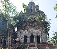 Radha Govinda temple
 Decorations in Radha Govinda temple
 Decorations in Radha Govinda temple
 Decorations in Radha Govinda temple


Healthcare
Bhupatinagar Mugberia Rural Hospital at Bhupatinagar (with 30 beds) is the major government medical facility in Bhagabanpur II CD block[6]
References
- "District Statistical Handbook 2014 Purba Medinipur". Table 2.2. Department of Planning and Statistics, Government of West Bengal. Archived from the original on 21 January 2019. Retrieved 22 April 2019.
- "CD block Wise Primary Census Abstract Data(PCA)". West Bengal – District-wise CD blocks. Registrar General and Census, India. Retrieved 16 August 2020.
- "Mugberia Gangadhar Mahavidyalaya". Mugberia Gangadhar Mahavidyalaya. Archived from the original on 10 October 2016. Retrieved 10 November 2016.
- "Mugberia Gangadhar Mahavidyalaya". College Admission. Retrieved 10 November 2016.
- McCutchion, David J., Late Mediaeval Temples of Bengal, first published 1972, reprinted 2017, page 52. The Asiatic Society, Kolkata, ISBN 978-93-81574-65-2
- "Health & Family Welfare Department". Health Statistics. Government of West Bengal. Retrieved 27 March 2019.
External links
| Wikimedia Commons has media related to Jukhia, Bhagabanpur II CD block. |
Cities, towns, locations and neighbourhoods in Purba Medinipur District, Medinipur division | ||||||||||
|---|---|---|---|---|---|---|---|---|---|---|
| Cities, municipal and census towns |
|  | ||||||||
| Locations other than cities and towns |
| |||||||||
| Neighbourhoods |
| |||||||||
| Related topics |
| |||||||||
Другой контент может иметь иную лицензию. Перед использованием материалов сайта WikiSort.org внимательно изучите правила лицензирования конкретных элементов наполнения сайта.
WikiSort.org - проект по пересортировке и дополнению контента Википедии