world.wikisort.org - India
Mainaguri is a town and a municipality in the Jalpaiguri Sadar subdivision of the Jalpaiguri district in the state of West Bengal, India.[4] It is known as the "Gateway of the Dooars" and is a regionally significant tourist destination for "Jalpesh Temple" of Lord Shiva and nearby Gorumara National Park.
Maynaguri | |
|---|---|
Town | |
 | |
| Nickname: Gateway of Dooars | |
 Maynaguri Location in West Bengal, India  Maynaguri Maynaguri (India)  Maynaguri Maynaguri (Asia) | |
| Coordinates: 26.564°N 88.820°E | |
| Country | |
| State | West Bengal |
| District | Jalpaiguri |
| Government | |
| • Type | Municipality, Panchayat Samiti |
| • Body |
|
| • Chairman | Ananta Deb Adhikari |
| • Sabhapati | Sibam Roy Basunia |
| Area | |
| • Total | 12.38 km2 (4.78 sq mi) |
| Elevation | 84 m (276 ft) |
| Population (2011) | |
| • Total | 45,045 |
| • Density | 3,600/km2 (9,400/sq mi) |
| Languages | |
| • Official | Bengali[1][2] |
| • Additional official | English[1] |
| Time zone | UTC+5:30 (IST) |
| PIN | 735224[3] |
| Vehicle registration | WB |
| Lok Sabha constituency | Jalpaiguri |
| Vidhan Sabha constituency | Maynaguri |
Geography
CT: census town, R: rural/ urban centre, N: neighbourhood, C: cantonment, NP: national park/ wildlife sanctuary, TE: tea estate
Abbreviations used in names – TG for Tea Garden (town/village), TE for Tea Estate, JRS: junction railway station
Owing to space constraints in the small map, the actual locations in a larger map may vary slightly
Area overview
The map alongside shows the alluvial floodplains south of the outer foothills of the Himalayas. The area is mostly flat, except for low hills in the northern portions.[5][6] It is a primarily rural area with 62.01% of the population living in rural areas and a moderate 37.99% living in the urban areas.[7][8] Tea gardens in the Dooars and Terai regions produce 226 million kg or over a quarter of India's total tea crop.[9][10] Some tea gardens were identified in the 2011 census as census towns or villages.[11] Such places are marked in the map as CT (census town) or R (rural/ urban centre). Specific tea estate pages are marked TE.
Note: The map alongside presents some of the notable locations in the subdivision. All places marked in the map are linked in the larger full screen map.
Location
Mainaguri is located at 26.57°N 88.82°E.[12] It has an average elevation of 84 metres (275 feet).
Mainaguri is about 10 km north-east of Jalpaiguri and 50 km from Siliguri. Local attractions include Jalpesh Temple, Gorumara National Park and Chapramari Wildlife Sanctuary. The nearest airport is Civil Enclave Bagdogra, and the nearest railway station is New Mainaguri.[13]
Five roads connect Mainaguri with
- Siliguri, Jalpaiguri (West)
- Alipurduar, Cooch Behar (East)
- Changrabandha, Mathabhanga (South)
- Malbazar, Lataguri (North)
- Ramsai (North-west).[14]
Civic administration
Maynaguri is mainly governed by Maynaguri municipality. Maynaguri covers wards spread across Madhabdanga-I and Maynaguri panchayats and parts of Khagrabari-I and Domohoni-I panchayats of Maynaguri block.[15]
Police station
Mainaguri police has jurisdiction over Maynaguri CD block.[16]
CD block HQ
Headquarters of Maynaguri CD block is at Mainaguri.[17]
Demographics
According to the 2011 Census of India, Mainaguri had a total population of 30,490 of which 15,487 (51%) were males and 15,003 (49%) were females. There were 2,951 persons in the age range of 0 to 6 years. The total number of literate people in Mainaguri was 24,408 (88.63% of the population over 6 years).[18]
As of 2001[update] India census,[19] Mainaguri had a population of 27,086. Males constitute 51% of the population and females 49%. Mainaguri has an average literacy rate of 75%, higher than the national average of 59.5%: male literacy is 80%, and female literacy is 70%. In Mainaguri, 11% of the population is under 6 years of age.
In 2021, Maynaguri municipality was formed comprising Maynaguri census town and Madhabdanga-I and Maynaguri panchayats and parts of Khagrabari-I and Domohoni-I panchayats of Maynaguri block. The population of the new municipality was 45,045.
Infrastructure

According to the District Census Handbook 2011, Jalpaiguri, Mainaguri covered an area of 12.38 km2. Among the civic amenities, it had 28 km roads with open drains, the protected water supply involved overhead tanks, uncovered wells. It had 3,458 domestic electric connections, 518 road lighting points. Among the medical facilities it had 1 hospital, 3 dispensaries/ health centres, 30 medicine shops. Among the educational facilities it had 12 primary schools, 5 middle schools, 5 secondary schools, 5 senior secondary schools. It had 4 recognised shorthand, typewriting and vocational training centre, 24 non-formal education centres (Sarva Shiksha Abhiyan), 1 special school for the disabled. Among the social, recreational and cultural facilities it had 1 cinema theatre, 1 auditorium/ community hall, 1 public library. Three important commodities it produced were: furniture, jute yarn, tea. It had branches of 2 nationalised banks, 1 private commercial bank and 1 cooperative bank.[20]
Education
- Maynaguri College is affiliated by North Bengal University.
- Maynaguri Government Polytechnic College.
Radhika Library, has been operating here since 1910. Radhikanath Nandi who was the Deputy Collector of the Khasmahal office at Mainaguri, helped to begin the library. At the beginning, 1 anna was decided as the monthly fees of the library. It used to be a rural library. It was upgraded as town library on 1 March 1983. It has more than 14,000 books and around 600 members.[21]
Transport
Road:

The main mode of transport in the area is roadways. Most of the places are well connected by roads and to rest of India. National Highway 27 (India) is the main highway of the area. Regular bus services provided by North Bengal State Transport Corporation and Assam State Transport Corporation and other private parties run between all important places of the area. Share jeeps and maxi-taxies are quite popular in the area.
Rail:

Mainaguri lies in the Northeast Frontier Railway zone of the Indian Railways. There are railway links to the rest of the country directly and via Kolkata. The major railway junction of New Jalpaiguri (Code:NJP) is 45 km from the town. New Mainaguri railway station (NMX) serves the town directly. Another rail station of this city is Maynaguri Road Railway Station (MYGD). It is about 5 km from the city. Maynaguri Road station is an important station of Malbazar-Changrabandha. Previously it was known as Doars railway. Mainaguri Road station is also 'Y' connected with New Maynaguri and New Domohoni rail station.
Places of interest

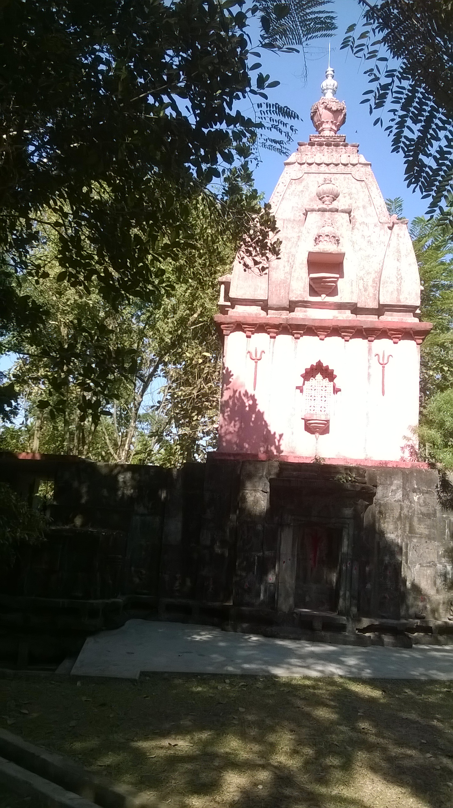
Jalpesh Temple
The Jalpesh Temple is approximately 3 kilometres from away Mainaguri 26°31′32″N 88°52′1″E, and is dedicated to Lord Jalpeshwar (Siva). The temple was built in a style akin to Islamic architecture. Inside the temple, there is a Shivling called 'Anadi'. Mahashivaratri is the main festival celebrated in this temple, which is 126 feet high and 120 feet wide.[22] Pilgrims come during Sravani Mela in July–August and during the fair of Jalpesh Mela in February–March to offer special puja to Siva. After worshipping, devotees, whose number reach approximately 1.2 million, collect water from River Teesta and walk barefoot 15 kilometres to the temple.[23]
Jalpesh Temple was founded by Bisu Singh of Cooch Behar in A.D. 1524. His son, Maharaja Narayan, rebuilt the temple in A.D. 1563. Pran Narayan in turn rebuilt the temple in A.D. 1663[24]
Other places
- Jatileswar Temple(dedicated to Lord Jatileshwara or Lord Shiva)
- Bateshwar Temple
- Mahakal Temple
- Ramsai Wildlife(Gorumara National Park)
- Khuksiya Park
- Maynaguri Shishu Uddyan
- Maynaguri Football field
Culture
Festivals
Various festivals are celebrated throughout the year. Kali Puja of Mainaguri is renowned. It also celebrates Eid and Christmas Day with similar pompousness.
Sports and entertainment
Mainaguri has a famous playground (Known as Mainaguri Football Ground) where several football tournaments are held every year.
Other than that several fairs like Boishakhi Mela, Mela during Durga Puja, book fair, one yearly cultural function organised by local clubs is also held. This ground is an inseparable part of the people of Mainaguri.
Healthcare
Maynaguri Rural Hospital, with 60 beds at Mainaguri, is the major government medical facility in the Maynaguri CD block.[25]
References
- "Fact and Figures". Wb.gov.in. Retrieved 14 August 2019.
- "52nd Report of the Commissioner for Linguistic Minorities in India" (PDF). Nclm.nic.in. Ministry of Minority Affairs. p. 85. Archived from the original (PDF) on 25 May 2017. Retrieved 14 August 2019.
- "Maynaguri Pin Code, Search Maynaguri JALPAIGURI PinCode". www.citypincode.in. Retrieved 10 February 2020.
- "Two new civic bodies for Jalpaiguri and Alipurduar districts".
- Debnath, S. (2010). The Dooars in Historical Transition (PDF). Shiv Mandir: N. L. Publishers.
- Dinerstein, E., Loucks, C. (2001). "Terai-Duar savanna and grasslands". Terrestrial Ecoregions. World Wildlife Fund.
- "Jalpaiguri". District Profile. District administration. Retrieved 13 July 2020.
- "District Statistical Handbook 2014 Jalpaiguri". Tables 2.2, 2.4b. Department of Planning and Statistics, Government of West Bengal. Retrieved 13 July 2020.
- "Tea Growing Regions". Dooars and Terai. Indian Tea Association. Retrieved 13 July 2020.
- "Dooars-Terai". Tea Board India. Retrieved 13 July 2020.
- "2011 Census – Primary Census Abstract Data Tables". West Bengal – District-wise. Registrar General and Census Commissioner, India. Retrieved 13 July 2020.
- "Maps, Weather, and Airports for Mainaguri, India". www.fallingrain.com. Retrieved 10 February 2020.
- "Mainaguri in Mainaguri India". www.india9.com. Retrieved 10 February 2020.
- "Mainaguri Pincode". citypincode.in. Retrieved 19 May 2014.
- "পুরসভার মর্যাদা পেল দু'জেলার দুই শহর".
- "District Statistical Handbook 2014 Jalpaiguri". Tables 2.1, 2.2. Department of Statistics and Programme Implementation, Government of West Bengal. Retrieved 2 July 2020.
- "District Census Handbook, Jalpaiguri, Series 20, Part XIIA" (PDF). Census of India 2011, Fifth page, map of Jalpaiguri district. Directorate of Census Operations, West Bengal. Retrieved 2 July 2020.
- "2011 Census – Primary Census Abstract Data Tables". West Bengal – District-wise. Registrar General and Census Commissioner, India. Retrieved 2 July 2020.
- "Census of India 2001: Data from the 2001 Census, including cities, villages and towns (Provisional)". Census Commission of India. Archived from the original on 16 June 2004. Retrieved 1 November 2008.
- "District Census Handbook Jalpaiguri, Census of India 2011, Series 20, Part XII A" (PDF). Section II Town Directory, Pages 451-453: Statement I: Status and Growth History, Pages 454-455: Statement II: Physical Aspects and Location of Towns, Pages 456-457: Statement III: Civic and other Amenities, Pages 458-459: Statement IV: Medical Facilities 2009, Pages 460—463: Statement V: Educational, Recreational and Cultural Facilities, Pages 464: Statement VI:Industry and Banking. Directorate of Census Operations V, West Bengal. Retrieved 26 June 2020.
- "Town Library Automation " Radhika Library". Retrieved 10 February 2020.
- "Jalpesh Shiva Temple in Jalpaiguri India". www.india9.com. Retrieved 10 February 2020.
- "Tourist Places in North Bengal | North Bengal Tourism". www.north-bengal.com. Retrieved 10 February 2020.
- "Cooch Behar Government: Royal History : Book of Facts and Events". Archived from the original on 23 October 2018. Retrieved 26 October 2008.
- "Health & Family Welfare Department" (PDF). Health Statistics – Rural Hospitals. Government of West Bengal. Retrieved 2 July 2020.
Cities, towns and locations in Jalpaiguri district | |||||
|---|---|---|---|---|---|
| Cities, municipal and census towns |
| ||||
| Locations other than cities and towns |
| ||||
| Specific Tea Estates |
| ||||
| Related Topics |
| ||||
Другой контент может иметь иную лицензию. Перед использованием материалов сайта WikiSort.org внимательно изучите правила лицензирования конкретных элементов наполнения сайта.
WikiSort.org - проект по пересортировке и дополнению контента Википедии