world.wikisort.org - India
Arambagh is a town and a municipality in Hooghly district in the state of West Bengal, India. It is the headquarters of Arambagh subdivision.[3]
This article needs additional citations for verification. (April 2011) |
Arambagh | |
|---|---|
Town | |
 Arambagh Location in West Bengal, India  Arambagh Arambagh (India) | |
| Coordinates: 22.88°N 87.78°E | |
| Country | |
| State | West Bengal |
| District | Hooghly district |
| Government | |
| • Type | Municipality |
| • Body | Arambagh Municipality |
| • Municipality Chairman | Swapan Nandi |
| Area | |
| • Total | 117.20 km2 (45.25 sq mi) |
| Elevation | 15 m (49 ft) |
| Population (2011)[2] | |
| • Total | 66,175 |
| • Density | 560/km2 (1,500/sq mi) |
| Languages | |
| • Official | Bengali, English |
| Time zone | UTC+5:30 (IST) |
| PIN | 712601 |
| Telephone code | +91 (0) 3211 |
| Vehicle registration | WB-16A*-**** |
| Lok Sabha constituency | Arambag |
| Vidhan Sabha constituency | Arambag |
Geography
M: municipal city/ town, R: rural/ urban centre, H: historical/ religious centre
Owing to space constraints in the small map, the actual locations in a larger map may vary slightly
Location
Arambagh is located at 22.88°N 87.78°E. It has an average elevation of 15 metres (118 feet). The town is situated on the link Road (state highway-2) 81Km north-west of Kolkata, 27 Km north-west of Tarakeswar, 39 Km south-east of Bardhaman. It is located on the bank of the Dwarakeswar River.
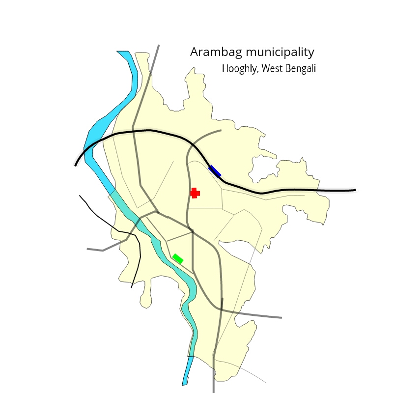
Area overview
The Arambagh subdivision, presented in the map alongside, is divided into two physiographic parts – the Dwarakeswar River being the dividing line. The western part is upland and rocky – it is extension of the terrain of neighbouring Bankura district. The eastern part is flat alluvial plain area. The railways, the roads and flood-control measures have had an impact on the area.[4] The area is overwhelmingly rural with 94.77% of the population living in rural areas and 5.23% of the population living in urban areas.[5]
Note: The map alongside presents some of the notable locations in the subdivision. All places marked in the map are linked in the larger full screen map.
Climate
The maximum temperature during summer rises up to 42 °C (2016) while minimum temperature during winter comes down to 8 °C. Average annual rainfall is 1600 millimetres.
Demographics
According to the 2011 Census of India, Arambagh had a total population of 66,175 of which 33,443 (51%) were males and 32,732 (49%) were females. Population in the age range 0–6 years was 6,522. The total number of literate persons in Arambagh was 48,338 (81.03% of the population over 6 years).[2]
As of 2001[update] India census,[6] Arambagh had a population of 66,175. Males constitute 62% of the population and females 38%. Arambagh has an average literacy rate of 82%, higher than the national average of 59.5%; with 79% male literacy and 58% of female literacy. 17% of the population is under 6 years of age.
Civic administration

Police station
Arambagh police station has jurisdiction over Arambagh municipal area and Arambagh CD block.[7][8] The headquarters of Arambagh CD block are located at Arambagh.[9]
Economics
This is a rice and potato agricultural area with several rice mills and cold storages.[10]Many Top branded companies set up their business in Arambagh.
History


Arambagh sub-division was formed in 1879. It was known as Jahanabad Sub-Division as the headquarters of the sub-division was the town of Jahanabad.Bankim Chandra Chattopadhyay was the first Sub-Divisional Officer of Arambagh. On 19 April 1900 the name was changed from Jahanabad to Arambagh, which means "the garden of ease and comfort". Other prominent figures from the district were:
- Rammohan Roy – Reformer. He was Ambassador of Mughal Emperor.
- Prafulla Chandra Sen – Freedom fighter, Chief Minister of W.B.
- Ramkrishna Parmahnsa - Indian Hindu mystic and saint during the 19th century Bengal. Kamarpukur was his birthplace.
- Prasanna Kumar Sarbadhikary – First Patiganit (arithmetic book in Bengali) writer.
- Nandlal Maity - Writer of history of mathematics in Bengali in three volume.
- Narayan Ch Ghosh - Defined the term Folkmathematics - mathematics that is manifestation of folk life.
Education
Libraries
Two government sponsored public libraries are situated in Arambagh. Raja Rammohan Roy Pathagar-o- Sanskriti Parishad is the oldest and most popular library of this area. Another library is Arambagh Sub Divisional library. Besides these two, there are many other public libraries in the surrounding area.
CBSE affiliated Schools

- Arambagh Vivekananda Academy (CBSE)
- Jawahar Navodaya Vidyalaya, Hooghly
CISCE (ICSE/ISC) Schools
- Sarada Vidyapith, but the school is not affiliated.
Kids Star Play School for ages 2 to 6, cares childs holistic development.
West Bengal Board affiliated schools

Pearl Rosary School is the most renowned school in the locality. The school is affiliated to WBBSE and WBCHSE. The school is an authorised study centre of National Institute of Open Schooling (NIOS), Govt of India.
- Kapsit High School, Kapsit, Arambagh, Hooghly
- Batanal Union High School
- Arambag High School
- Kalipur Swamiji High School
- Pearl Rosary School
- Bajua High School
- Arambagh Girls High School
- Kanpur Krishnabati Vivekananda Institution
- Parul Ramkrishna Sarada High School
- Arambagh Boys Primari School
- Basanta Prathamik Vidhyalaya
- K.B.Roy High School
- Saraswati Sishu Mandir, Balibela
- Tirol High School, Tirol
- Gourhati Haradas Institution
- Golta High School
- Golta Nimna Buniadi Vidyalaya
- Joyrampur Netaji High School
- Muthadanga R.K. High School
- Pirijpur Hamidannesa Vidyapith
- Bhurkunda High School (H.S)
- Naisarai High School
- Nirvoipur Badalkona Giya Nilkantha Sikshanikaten
- Uttor Badalkona Prathomik Bidyaloy
- Hatbasantapur Hara Parbbati Institution (H.S.)
- Goghat High School (HS)
- Bengai High School
- Shaikhpur High School, Uttar Rasulpur, Hooghly
- Karui P.C High School (H.S) Karui, arambagh, hooghly, 712615
- Baradongal R N Institution (H.S), Baradongal, Hooghly, 712617
- Kumursha Sital Chandra Dey Vidyamandir (H.S), Kumursha, Hooghly, 712616
- Saora Union High School, Saora, hooghly
- Ghoshpur Union Netaji Vidyapith, Ghoshpur, Hooghly
- Gourhati Haradas Institution
- Raghunathput Saradamoni Valika Vidyalaya
- Ghasua Janata High School
- Mayal K.C. Roy Institution
- Thakuranichak Union High School
- Thakuranichak BBD Institution
- Dhanyaghori High School, Bandar
- Ghoradaha Sudhanya Charan High School
- Pole P.C.Sen High School
- Bengejola High School
- Ramnagar Atul Vidyalaya
- Madhurpur High School
- Patul Ganeshbazar High School(HS)
- Radhaballavpur High School
- Balarampur Primary School
- Mohanpur Primary School
- Khudiram Child Learning Centre (primary school)
- Anandamarga School (primary school), Rabindrapally, Arambagh
- Sisu Guchho (primary school)
- Kashinath Primary School
- Nirvoipur Primary School
- Chandibati Primary School
- Basudevpur Parul Jr. Basic School
- Dihibayra Primary School
- Haripur Sayedia Primary School
- Kamarpukur Ramakrishna Mission Multipurpose School
- Garh Mandaran High School
- Dakshin Rasulpur High School (H.S)
- Paschim Ghoshpur Ramkrishna Bidyapith (H.S)
General degree colleges
- Aghorekamini Prakashchandra Mahavidyalaya, Bengai, Goghat II CD Block
- Arambagh Girls' College, Arambagh
- Kabikankan Mukundaram Mahavidyalaya, Keshabpur, Arambagh CD Block
- Netaji Mahavidyalaya, Kalipur, Arambagh
- Rabindra Mahavidyalaya, Champadanga, Pursurah
- Raja Rammohan Roy Mahavidyalaya, Radhanagore, Khanakul I CD Block
- Sri Ramkrishna Sarada Vidyamahapith, Kamarpukur, Goghat II CD Block
Polytechnic
- ITI-Bengai, Goghat
- Arambagh Government Polytechnic, Arambagh
See also
References
- "Arambagh Municipality". Hooghly district information. Hooghly district authorities. Archived from the original on 20 July 2017. Retrieved 14 July 2017.
- "2011 Census – Primary Census Abstract Data Tables". West Bengal – District-wise. Registrar General and Census Commissioner, India. Retrieved 15 June 2016.
- District-wise list of statutory towns Archived 27 September 2007 at the Wayback Machine
- "District Census Handbook: Hugli, Series-20, Part XIIA" (PDF). Physiography, Page 17-19. Directorate of Census Operations, West Bengal, 2011. Retrieved 25 September 2020.
- "District Statistical Handbook 2014 Hooghly". Table 2.2, 2.4(a). Department of Planning and Statistics, Government of West Bengal. Retrieved 25 September 2020.
- "Census of India 2001: Data from the 2001 Census, including cities, villages and towns (Provisional)". Census Commission of India. Archived from the original on 16 June 2004. Retrieved 1 November 2008.
- "District Statistical Handbook 2014 Hooghly". Tables 2.1, 2.2. Department of Statistics and Programme Implementation, Government of West Bengal. Archived from the original on 21 January 2019. Retrieved 15 October 2018.
- "Hooghly District Police". West Bengal Police. Archived from the original on 5 July 2017. Retrieved 20 June 2017.
- "District Census Handbook: Hugli, Series-20, Part XIIA" (PDF). Map of Hooghly district with CD Block HQs and Police Stations (on the fifth page). Directorate of Census Operations, West Bengal, 2011. Retrieved 20 June 2017.
- "List of functioning Cold Storage of West Bengal District wise as on 18.01.07". West Bengal State Marketing Board. Archived from the original on 22 January 2009. Retrieved 28 January 2009.
На других языках
[de] Arambag
Arambag, auch Arambagh, ist eine Stadt im indischen Bundesstaat Westbengalen.- [en] Arambag
Другой контент может иметь иную лицензию. Перед использованием материалов сайта WikiSort.org внимательно изучите правила лицензирования конкретных элементов наполнения сайта.
WikiSort.org - проект по пересортировке и дополнению контента Википедии