world.wikisort.org - India
Alipur is a village in Chanditala I community development block of Srirampore subdivision in Hooghly district in the Indian state of West Bengal.[1]
Alipur | |
|---|---|
Village | |
 Alipur Location in West Bengal, India  Alipur Alipur (India) | |
| Coordinates: 22.7130601°N 88.18873°E | |
| Country | |
| State | West Bengal |
| District | Hooghly |
| Government | |
| • Body | Gram panchayat |
| Population (2011) | |
| • Total | 3,091 |
| Languages | |
| • Official | Bengali, English |
| Time zone | UTC+5:30 (IST) |
| ISO 3166 code | IN-WB |
| Vehicle registration | WB |
| Lok Sabha constituency | Serampore |
| Vidhan Sabha constituency | Chanditala |
| Website | wb |
Geography
Alipur is located at 22.7130601°N 88.18873°E.
Gram panchayat
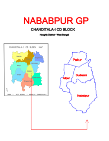
Villages and census towns in Nababpur gram panchayat are: Alipur, Dudhkalmi, Nababpur and Pakur.[2]
Demographics
As per 2011 Census of India, Alipur had a total population of 3,091 of which 1,585 (51%) were males and 1,506 (49%) were females. Population below 6 years was 302. The total number of literates in Alipur was 2,467 (88.45% of the population over 6 years).[3]
References
- "banglarbhumi.gov.in". WEST BENGAL ->HUGLI(হুগলী) ->CHANDITALA-I (চণ্ডীতলা-১) Mouza Information. Government of West Bengal. Archived from the original on 22 December 2016. Retrieved 6 October 2018.
- "Pakur". Indian Village Directory. Retrieved 12 October 2018.
- "C.D. Block Wise Primary Census Abstract Data(PCA)". 2011 census: West Bengal – District-wise CD Blocks. Registrar General and Census Commissioner, India. Retrieved 7 October 2018.
Cities, towns and locations in Hooghly district | |||||||||
|---|---|---|---|---|---|---|---|---|---|
| Cities, municipalities and census towns |
| ||||||||
| Locations other than cities and towns |
| ||||||||
| Neighbourhoods |
| ||||||||
| Related topics |
| ||||||||
This article about a location in the Hooghly district of West Bengal is a stub. You can help Wikipedia by expanding it. |
Текст в блоке "Читать" взят с сайта "Википедия" и доступен по лицензии Creative Commons Attribution-ShareAlike; в отдельных случаях могут действовать дополнительные условия.
Другой контент может иметь иную лицензию. Перед использованием материалов сайта WikiSort.org внимательно изучите правила лицензирования конкретных элементов наполнения сайта.
Другой контент может иметь иную лицензию. Перед использованием материалов сайта WikiSort.org внимательно изучите правила лицензирования конкретных элементов наполнения сайта.
2019-2026
WikiSort.org - проект по пересортировке и дополнению контента Википедии
WikiSort.org - проект по пересортировке и дополнению контента Википедии