world.wikisort.org - India
Dhuliyan is a municipality town in the Jangipur subdivision of Murshidabad district in the state of West Bengal, India. It is located between the Ganges and the Hooghly River.
Dhuliyan
Dhulian | |
|---|---|
Town | |
 Ganga River in Dhulian | |
 Dhuliyan Location in West Bengal, India  Dhuliyan Dhuliyan (India) | |
| Coordinates: 24.681°N 87.954°E | |
| Country | |
| State | West Bengal |
| District | Murshidabad |
| Dhulian | 1909 |
| Government | |
| • Type | Federal democracy |
| • Administrative Division | Malda |
| Area | |
| • Total | 6.25 km2 (2.41 sq mi) |
| Elevation | 4 m (13 ft) |
| Population (2011)[1] | |
| • Total | 95,713 |
| • Density | 15,000/km2 (40,000/sq mi) |
| Languages | |
| • Official | Bengali, English |
| Time zone | UTC+5:30 (IST) |
| PIN | 742202 |
| Telephone code | +91-3485 |
| Vehicle registration | WB58, WB94 |
| Lok Sabha constituency | Maldaha Dakshin |
| Vidhan Sabha constituency | Samserganj |
| Website | http://dhuliyanmunicipality.in |
| murshidabad | |
Dhuliyan has been mentioned as an inland water transport (IWT) trading point between Murshidabad and the city of Rajshahi in Bangladesh. Low-cost barges could ply the Ganges river, called Padma in downstream Bangladesh, exchanging goods and reducing smuggling. This proposal has not been agreed to yet by the two countries. Old Dhulian Railway station under the Ganga River near Lalpur, Present Railway station name Dhulian Ganga .
Geography
M: municipal town, CT: census town, R: rural/ urban centre, F: Facility
Abbreviation- TPS: Thermal Power Station
Owing to space constraints in the small map, the actual locations in a larger map may vary slightly
Location
Dhuliyan has an average elevation of 4 metres (13 feet).
Dhuliyan is surrounded by Farakka (to the north), Aurangabad (to the South) Pakur (to the West) and Ganga River - (to the East). Malda district and Chapai Nababganj of Bangladesh lies to the east across the river. Dhuliyan lies on the right bank of the Ganga river.
Dhuliyan includes Dhuliyan Bazar, Jafrabad, Tinpakuria, Kankuria, Ratanpur, House Nagar, Anup Nagar & Dakbanglow area.
Area overview
Jangipur subdivision is crowded with 52 census towns and as such it had to be presented in two location maps. One of the maps can be seen alongside. The subdivision is located in the Rarh region that is spread over from adjoining Santhal Pargana division of Jharkhand. The land is slightly higher in altitude than the surrounding plains and is gently undulating.[2][3] The river Ganges, along with its distributaries, is prominent in both the maps. At the head of the subdivision is the 2,245 m long Farakka Barrage, one of the largest projects of its kind in the country.[4] Murshidabad district shares with Bangladesh a porous international border which is notoriously crime prone (partly shown in this map).[5] The subdivision has two large power plants - the 2,100 MW Farakka Super Thermal Power Station and the 1,600 MW Sagardighi Thermal Power Station.[6][7] According to a 2016 report, there are around 1,000,000 (1 million/ ten lakh) workers engaged in the beedi industry in Jangipur subdivision. 90% are home-based and 70% of the home-based workers are women.[8][9][10] As of 2013, an estimated 2.4 million people reside along the banks of the Ganges alone in Murshidabad district. Severe erosion occurs along the banks.[11]
Note: The two maps present some of the notable locations in the subdivision. All places marked in the maps are linked in the larger full screen maps.
Effects of the Ganges erosion
Dhuliyan town has to face the burnt of erosion repeatedly due to its proximity to the Ganges. The town has shifted westward at least five kms from its original location.
During 1952-53 the old Dhuliyan town was completely washed away by the river. Dhuliyan and its adjoining areas were greatly affected in mid 1970s when about 50,000 people became homeless. The encroaching river wiped out 50 mouzas and engulfed about 10,000 hectares of fertile land.[12][13] In August 2020, this region again faced erosion which washed away dwelling places, temples, schools, litchi and mango orchards and agricultural lands along the right bank nearly after 50 years. It affected namely Dhanghora, Dhusaripara and Natun Shibpur villages of Samserganj block.[14]
Demographics
The Dhulian Municipality has population of 95,706 of which 47,635 are males while 48,071 are females as per report released by Census India 2011. The literacy rate is 63.03%. Male literacy is around 69.15% while female literacy is 56.98%.[15]
In the 2011 Census of India, Dhuliyan Urban Agglomeration had a population of 239,022, out of which 119,151 were males and 119,871 were females.[16]
As of 2001[update] India census,[17] Dhulian had a population of 72,906 of which males are 36524 and females are 36382. Dhulian had an average literacy rate of 39%. Male literacy was 48% and female literacy was 31%.
Civic administration
Police station
Samserganj police station, located in Dhulian, has jurisdiction over Samserganj CD block.[18]
CD block HQ
The headquarters of Samserganj CD block are located at Dhulian.[19]
Infrastructure
According to the District Census Handbook, Murshidabad, 2011, Dhulian covered an area of 6.25 km2. It had 131.95 km roads with open drains. The protected water-supply involved overhead tank, tap water from untreated source, hand pump. It had 6,071 domestic electric connections, 1 road lighting point. Among the medical facilities it had 1 hospital, 5 dispensaries/ health centres, 2 charitable hospitals/ nursing homes, 23 medicine shops. Among the educational facilities, it had 50 primary schools, 3 secondary schools, 3 senior secondary schools in town, 1 general degree college at Tarapar 3.5 km away. It had 4 recognised shorthand, typewriting & vocational training institutes, 1 non-formal education centre (Sarva Shiksha Abhiyan). Among the social, recreational & cultural facilities it had 1 public library, 1 reading room. It produced beedi, knitted products, pottery. It had the branch offices of 2 nationalised banks, 1 agricultural credit society, 1 non-agricultural credit society.[20]
Transport
Barharwa–Azimganj–Katwa loop incl. Nalhati–Azimganj branch line | ||||||||||||||||||||||||||||||||||||||||||||||||||||||||||||||||||||||||||||||||||||||||||||||||||||||||||||||||||||||||||||||||||||||||||||||||||||||||||||||||||||||||||||||||||||||||||||||||||||||||||||||||||||||||||||||||||||||||||||||||||||||||||||||||||||||||||||||||||||||||||||||||||||||||||||||||||||||||||||||||||||||||||||||||||||||||||||||||||||||||||||||||||||||||||||||||||||||||||||||||||||||||||||||||||||||||||||||||||||||||||||||||||||||||||||||||||||||||||||||||||||||||||||||||||||||||||||||||
|---|---|---|---|---|---|---|---|---|---|---|---|---|---|---|---|---|---|---|---|---|---|---|---|---|---|---|---|---|---|---|---|---|---|---|---|---|---|---|---|---|---|---|---|---|---|---|---|---|---|---|---|---|---|---|---|---|---|---|---|---|---|---|---|---|---|---|---|---|---|---|---|---|---|---|---|---|---|---|---|---|---|---|---|---|---|---|---|---|---|---|---|---|---|---|---|---|---|---|---|---|---|---|---|---|---|---|---|---|---|---|---|---|---|---|---|---|---|---|---|---|---|---|---|---|---|---|---|---|---|---|---|---|---|---|---|---|---|---|---|---|---|---|---|---|---|---|---|---|---|---|---|---|---|---|---|---|---|---|---|---|---|---|---|---|---|---|---|---|---|---|---|---|---|---|---|---|---|---|---|---|---|---|---|---|---|---|---|---|---|---|---|---|---|---|---|---|---|---|---|---|---|---|---|---|---|---|---|---|---|---|---|---|---|---|---|---|---|---|---|---|---|---|---|---|---|---|---|---|---|---|---|---|---|---|---|---|---|---|---|---|---|---|---|---|---|---|---|---|---|---|---|---|---|---|---|---|---|---|---|---|---|---|---|---|---|---|---|---|---|---|---|---|---|---|---|---|---|---|---|---|---|---|---|---|---|---|---|---|---|---|---|---|---|---|---|---|---|---|---|---|---|---|---|---|---|---|---|---|---|---|---|---|---|---|---|---|---|---|---|---|---|---|---|---|---|---|---|---|---|---|---|---|---|---|---|---|---|---|---|---|---|---|---|---|---|---|---|---|---|---|---|---|---|---|---|---|---|---|---|---|---|---|---|---|---|---|---|---|---|---|---|---|---|---|---|---|---|---|---|---|---|---|---|---|---|---|---|---|---|---|---|---|---|---|---|---|---|---|---|---|---|---|---|---|---|---|---|---|---|---|---|---|---|---|---|---|---|---|---|---|---|---|---|---|---|---|---|---|---|---|---|---|---|---|---|---|---|---|---|---|---|---|---|---|---|---|---|---|---|---|---|---|---|---|---|---|---|---|---|---|---|---|---|---|---|---|---|---|---|---|---|---|---|---|---|---|---|---|---|---|---|---|---|---|---|---|---|---|---|---|---|---|---|---|---|---|---|---|---|---|---|---|---|---|---|---|---|---|---|---|---|---|
| ||||||||||||||||||||||||||||||||||||||||||||||||||||||||||||||||||||||||||||||||||||||||||||||||||||||||||||||||||||||||||||||||||||||||||||||||||||||||||||||||||||||||||||||||||||||||||||||||||||||||||||||||||||||||||||||||||||||||||||||||||||||||||||||||||||||||||||||||||||||||||||||||||||||||||||||||||||||||||||||||||||||||||||||||||||||||||||||||||||||||||||||||||||||||||||||||||||||||||||||||||||||||||||||||||||||||||||||||||||||||||||||||||||||||||||||||||||||||||||||||||||||||||||||||||||||||||||||||
Dhulian Ganga railway station is situated in Malda railway division of Barharwa–Azimganj–Katwa loop line.
National Highway 12 (old no. NH 34) passes through Dhulian town.
Education
College
Nur Mohammad Smriti Mahavidyalaya was established in 2008 at Dhulian. It has Bengali, English, History, Sociology and Education departments.[21][22]
Schools
- Kanchantala Jagabandhu Diamond Jubilee Institution (Est 1897)
- Dhuliyan Balika Vidyalaya
- Dhuliyan Bani Chand Agarwala Balika Vidyalaya
- Dhuliyan High Madrasah
- Dhuliyan Krishna Kumar Santosh Kumar Smriti Vidyapith
- Dhuliyan Netaji Sishu Bikash Academy (H.S.)
- Dighri High School (H.S.)
- House Nagar High Madrasah (H.S)
- Saheb Nagar High School (H.S)
- Jaykrishnapur Ajimuddin Biswas Smriti Vidyapith
- Chachanda Basudebpur Jaladipur High School (H.S)
- Samsherganj government model school (Circus field)
- Rahmani Academy (Dhuliyan Branch of Al-Ameen Mission Trust)
- Gyan Sanchay Academy (In Collaboration with Al-Ameen Mission Trust)
- The Future Shining Academy
- Holyfaith Academy (Affiliated to CISCE)
- Novel Academy
- Al-Hera Academy
- Rising Sun Convent School
- Luther institutions
Culture
Dhuliyan stands on the bank of the Ganges, which has been changing its course regularly. A large part of the town has been ravaged and new areas have come up. Dhuliyan Rajbari has escaped the fury of the river and boasts of a 300 year old Durga Puja.[23][24]
Dhuliyan picture gallery
 Dhuliyan Rajbari
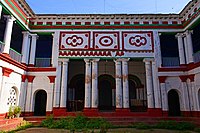 Dhuliyan Rajbari


Healthcare
- Anupnagar Rural Hospital, with 30 beds, is a major government facility in Samserganj (community development block).[25]
- Dhuliyan Diagnostic & Healthcare Pvt Ltd. (DDH)
- Tarapur Central Hospital for beedi workers at Tarapur, run by BWWF
See also
- River bank erosion along the Ganges in Malda and Murshidabad districts
References
- "Dhuliyan Info".
- "District Census Handbook: Murshidabad, Series 20 Part XII A" (PDF). Physiography, Page 13. Directorate of Census Operations, West Bengal, 2011. Retrieved 24 July 2017.
- "Murshidabad". Geography. Murshidabad district authorities. Retrieved 24 July 2017.
- "Farakka Barrage Project". FBP. Retrieved 12 September 2017.
- "Child labour, illness & lost childhoods, India's tobacco industry". Edge of Humanity Magazine, 27 December 2020. Retrieved 13 July 2021.
- "Power Generation". Farakka. NTPC. Retrieved 7 August 2016.
- "The West Bengal Power Development Corporation Limited". Sagardighi Thermal Power Project. WBPDCL. Retrieved 15 August 2017.
- Kar, Sunirmal. "Child workers in household industry: a study of beedi industry in Murshidabad district of West Bengal" (PDF). Viswa Bharati University thesis, page 5. Shodhganga. Retrieved 28 August 2017.
- "The 'Poor man's cigarette'". Gurvinder Singh. The Statesman, 22 January 2017. Retrieved 28 August 2017.
- "Beedi workers of Jangipur hold key". Indrani Dutta. The Hindu, 1 May 2009. Retrieved 28 August 2017.
- "Types and sources of floods in Murshidabad, West Bengal" (PDF). Swati Mollah. Indian Journal of Applied Research, February 2013. Archived from the original (PDF) on 20 August 2017. Retrieved 5 September 2017.
- Banerjee, Manisha. "A Report on the Impact of Farakka Barrage on the Human Fabric, November 1999" (PDF). The social impact of erosion, pp 13-14. South Asia Network On Dams, Rivers and People, New Delhi: 110 088 India. Retrieved 5 September 2017.
- "River bank erosion and environmental neo-refugees: A case study of Murshidabad district in West Bengal, India | International Journal of Current Research". www.journalcra.com. Retrieved 2 March 2022.
- "[Photos] Erosion along Ganga's riverbanks in West Bengal finds new victims". Mongabay-India. 2 November 2020. Retrieved 2 March 2022.
- "Dhuliyan::Municipality". dhuliyanmunicipality.in. Retrieved 27 May 2020.
- "Urban Agglomerations/Cities having population 1 lakh and above" (PDF). www.censusindia.gov.in. Retrieved 27 May 2020.
- "Census of India 2001: Data from the 2001 Census, including cities, villages and towns (Provisional)". Census Commission of India. Archived from the original on 16 June 2004. Retrieved 1 November 2008.
- "District Statistical Handbook 2014 Murshidabad". Table 2.1. Department of Statistics and Programme Implementation, Government of West Bengal. Archived from the original on 29 July 2017. Retrieved 17 May 2017.
- "District Census Handbook: Murshidabad, Series 20 Part XII A" (PDF). Map of Murshidabad with CD Block HQs and Police Stations (on the fourth page). Directorate of Census Operations, West Bengal, 2011. Retrieved 27 August 2017.
- "District Census Handbook Murshidabad, Census of India 2011, Series 20, Part XII A" (PDF). Section II Town Directory, Pages 981-987: Statement I: Growth History, Pages 990-993: Statement III: Civic & Other Amenities, Pages 993-995: Statement IV: Medical Facilities 2009, Pages 995-1001 Section V: Educational, Recreational and Cultural Facilities; Pages 1 001- 1002: Statement VI: Industry & Banking. Directorate of Census Operations, West Bengal. Retrieved 26 June 2021.
- "Nur Mohammad Smriti Mahavidyalaya". NMSM. Retrieved 12 September 2017.
- "Nur Mohammad Smriti Mahavidyalaya". College Admission. Retrieved 12 September 2017.
- "General Assurance Society Ltd vs Chandumull Jain And Anr on 7 February, 1966". Indian Kanoon. Retrieved 27 July 2021.
- "১৩দিন ধরে চলে মূর্শিদাবাদের ধূলিয়ান রাজবাড়ির ৩০০ বছরের পুরনো পুজো (300 years old puja at Dhuliyan Rajabari goes on 13 days)". in Bengali. One India. Retrieved 27 July 2021.
- "Health & Family Welfare Department". Health Statistics. Government of West Bengal. Retrieved 19 September 2017.
Cities, towns and locations in Murshidabad district, Malda division | |||||||||||
|---|---|---|---|---|---|---|---|---|---|---|---|
| Cities, municipal and census towns |  | ||||||||||
| Locations other than cities and towns |
| ||||||||||
| Neighbourhoods | |||||||||||
| Related topics |
| ||||||||||
Murshidabad district topics | |||||||||||
|---|---|---|---|---|---|---|---|---|---|---|---|
| General |
| | |||||||||
| History |
| ||||||||||
| Subdivisions | |||||||||||
| Municipalities |
| ||||||||||
| Community development blocks |
| ||||||||||
| Rivers | |||||||||||
| Transport |
| ||||||||||
| Railway stations | |||||||||||
| Institutes of higher learning |
| ||||||||||
| Lok Sabha constituencies |
| ||||||||||
| Vidhan Sabha constituencies | |||||||||||
| Former Vidhan Sabha constituencies | |||||||||||
| Villages | |||||||||||
| See also |
| ||||||||||
This article about a location in the Murshidabad district of West Bengal is a stub. You can help Wikipedia by expanding it. |
На других языках
[de] Dhulian
Dhulian ist eine Stadt im indischen Bundesstaat Westbengalen.- [en] Dhuliyan
[ru] Дхулиян
Дхулиян (англ. Dhulian, бенг. ধুলিয়ান) — город и муниципалитет в округе Муршидабад, штат Западная Бенгалия. Расположен в 305 км к северу от Калькутты, между реками Ганг и Хугли, на высоте 4 метра над уровнем моря. По данным переписи 2011 года население городской агломерации Дхулиян составляло 239 022 человека. Уровень грамотности равнялся 60,06 %.[2] Основной язык населения — бенгали.Другой контент может иметь иную лицензию. Перед использованием материалов сайта WikiSort.org внимательно изучите правила лицензирования конкретных элементов наполнения сайта.
WikiSort.org - проект по пересортировке и дополнению контента Википедии