world.wikisort.org - India
Panchrol is a village and a gram panchayat in the Egra I CD block in the Egra subdivision of the Purba Medinipur district in the state of West Bengal, India.
Panchrol | |
|---|---|
Village | |
 Panchrol Location in West Bengal, India  Panchrol Panchrol (India) | |
| Coordinates: 21.8331°N 87.4527°E | |
| Country | |
| State | West Bengal |
| District | Purba Medinipur |
| Population (2011) | |
| • Total | 5,615 |
| Languages | |
| • Official | Bengali, English |
| Time zone | UTC+5:30 (IST) |
| PIN | 721447 |
| Telephone/STD code | 03229 |
| Lok Sabha constituency | Midnapore |
| Vidhan Sabha constituency | Egra |
| Website | purbamedinipur |
History
In the Egra copper plate inscription recovered at Panchrol, it is mentioned that Ekatakaksha was an administrative centre during the rule of Shashanka.[1]
Geography
M: municipal city/ town, CT: census town, R: rural/ urban centre, H: historical/ religious centre.
Owing to space constraints in the small map, the actual locations in a larger map may vary slightly
Location
Panchrol is located at 21.8331°N 87.4527°E.
Urbanisation
96.96% of the population of Egra subdivision live in the rural areas. Only 3.04% of the population live in the urban areas, and that is the lowest proportion of urban population amongst the four subdivisions in Purba Medinipur district.[2]
Note: The map alongside presents some of the notable locations in the subdivision. All places marked in the map are linked in the larger full screen map.
Demographics
According to the 2011 Census of India, Panchrol had a total population of 5,615, of which 2913 (52%) were males and 2,702 (48%) were females. There were 543 persons in the age range of 0–6 years. The total number of literate persons in Panchrol was 4,425 (87.24% of the population over 6 years).[3]
Culture
David J. McCutchion mentions:[4]
- The Sharabhuja temple as a large Chandni or dalan type with verandah on three or more sides, measuring 27’ 3” x 42’ 9”, with terracotta and stucco work, belonging to the mid-19th century.
- The Madana Mohana temple belongs to the same category, measuring 24’ 3” x 39’ 7”, largely plain, belonging to the mid-19th century.
- The Vrindavanjiu temple belongs to the same category, measuring 24’ 3” x 25” 3”, with terracotta and stucco work, built in 1909.
- The Radha Vinoda temple is flat-roofed with smooth rekha superstructure, measuring 25” x 35’ 2”, with rich stucco work, built possibly in 1816. The upper rekha deul has a porch with cornice and straight ridging.
Panchrol picture gallery
 Radha Binoda temple
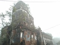 Radha Binoda temple
 Sharabhuja Gauranga temple
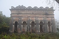 Sharabhuja Gauranga temple
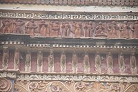 Terracotta relief at Gauranga temple
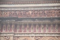 Terracotta relief at Gauranga temple
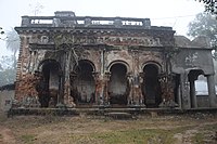 Madan Mohan temple
 Madan Mohan temple


Healthcare
There is a primary health centre at Kasabagola, PO Panchrol (with 2 beds).[5]
References
- "The Lost Capitals and Places". Ekatakaksha. Dandabhukti. Retrieved 15 August 2020.
- "District Statistical Handbook 2014 Purba Medinipur". Table 2.2. Department of Planning and Statistics, Government of West Bengal. Retrieved 15 August 2020.
- "CD block Wise Primary Census Abstract Data(PCA)". West Bengal – District-wise CD blocks. Registrar General and Census, India. Retrieved 15 August 2020.
- McCutchion, David J., Late Mediaeval Temples of Bengal, first published 1972, reprinted 2017, pages 65, 66. The Asiatic Society, Kolkata, ISBN 978-93-81574-65-2
- "Health & Family Welfare Department". Health Statistics. Government of West Bengal. Retrieved 15 August 2020.
External links
| Wikimedia Commons has media related to Panchrol, Egra I CD block. |
Cities, towns, locations and neighbourhoods in Purba Medinipur District, Medinipur division | ||||||||||
|---|---|---|---|---|---|---|---|---|---|---|
| Cities, municipal and census towns |
|  | ||||||||
| Locations other than cities and towns |
| |||||||||
| Neighbourhoods |
| |||||||||
| Related topics |
| |||||||||
Другой контент может иметь иную лицензию. Перед использованием материалов сайта WikiSort.org внимательно изучите правила лицензирования конкретных элементов наполнения сайта.
WikiSort.org - проект по пересортировке и дополнению контента Википедии