world.wikisort.org - Bangladesh
Pirojpur (Bengali: পিরোজপুর) is a district (zilla) in southern-western Bangladesh. It is a part of Barisal Division.[2]
This article needs additional citations for verification. (October 2009) |
Pirojpur
পিরোজপুর | |
|---|---|
District | |
| Pirojpur District | |
 Floating fields in Baithakatha village. | |
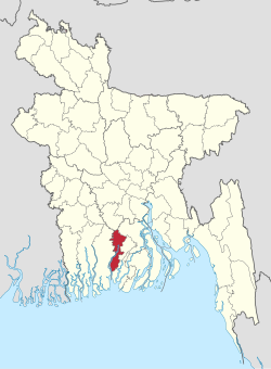 Location of Pirojpur in Bangladesh | |
 Expandable map of Pirojpur District | |
| Coordinates: 22.58°N 89.97°E | |
| Country | |
| Division | Barisal Division |
| Government | |
| • Deputy Commissioner | Abu Ali Md. Shazzad Hossain |
| Area | |
| • Total | 1,277.80 km2 (493.36 sq mi) |
| Population (2022 census) | |
| • Total | 1,198,193 |
| • Density | 940/km2 (2,400/sq mi) |
| Demonym(s) | Pirojpuri, Firozpuri |
| Time zone | UTC+06:00 (BST) |
| Postal code | 8500 |
| HDI (2018) | 0.672[1] medium · 2nd of 21 |
Etymology
According to myth, the second son of Subedar Shah Shuja, Firoz Shah, died in this area, and the area became known subsequently as 'Firozpur'. In time, the pronunciation 'Firozpur' slowly muted to 'Pirozpur' and later 'Pirojpur'.[3]
Geography
Most of the land is low-lying and the soil is fertile. There are small forests. Nesarabad is known for its business centre and also for the Sundori tree (a kind of mangrove) that grows there.
Rivers
Gabkhan, Baleshwar, Damodar, Kocha, Pona, Kochakhali, Kaliganga, Sandha, Doratana etc. are big and known rivers.
The Baleshwar, the river that is situated to the east of Sunder Bans splits into two parts, but this is getting smaller and smaller day by day. One is known as Doratana which flows through Bagerhat and the other and mightier one is known as Kacha which flows through Bhandaria. Then it has an offshoot Baleshwar which later meets with Doratana and falls into Kaliganga near Mativanga, Najirpur. And Kocha splits into two river Kaliganga and Sandha. Kaliganga flows to the north meets with Baleshwar and flow to further north. and Sandha flows to the east. Later Sandha coalesce with Arial Khan and falls into the Meghna.
Demographics
| Year | Pop. | ±% p.a. |
|---|---|---|
| 1974 | 823,787 | — |
| 1981 | 947,420 | +2.02% |
| 1991 | 1,063,185 | +1.16% |
| 2001 | 1,111,068 | +0.44% |
| 2011 | 1,113,257 | +0.02% |
| Sources:[4] | ||
Pirojpur District had a population of 1,113,257 according to the 2011 Bangladesh census, of which 548,228 were males and 565,029 females. 930,626 (83.59%) were rural and 182,631 (16.41%) were urban. The literacy rate was 64.85%: 65.04% for males and 64.68% for females.[4]
Religion
| Religion | Population (1941)[5]: 100–101 | Percentage (1941) | Population (2011)[4] | Percentage (2011) |
|---|---|---|---|---|
| Islam |
388,000 | 60.23% | 925,895 | 83.17% |
| Hinduism |
255,748 | 39.70% | 186,865 | 16.79% |
| Others [lower-alpha 2] | 477 | 0.07% | 497 | 0.04% |
| Total Population | 644,225 | 100% | 1,113,257 | 100% |
Islam is the predominant religion in the district, along with a large Hindu minority. But similar to other districts in the Barisal division, the minority Hindu population have not only seen a decline in their share of population, but also their absolute numbers, in the 2001-2011 period. The percentage share of Hindus is the largest in Nazirpur Upazila and the lowest in Zianagar Upazila.[4]
There are 3,087 mosques and 1,051 temples.[6]
Administration
The subdivision (then a mohokooma, now a zilla) of Pirojpur was created on 28 October 1859 Pirojpur district was formed on 1 March 1984 and the municipality was formed in 1885. The area of Pirojpur is 1277.80 km2. It is under Barisal Division. There are three municipalities in Pirojpur named Pirojpur, Bhandaria, Mathbaria. There are seven upazilas (sub districts) in Pirojpur district: Pirojpur Sadar, Bhandaria, Mathbaria, Indurkani, Nazirpur, Nesarabad and Kawkhali. Of these, Mathbaria is the largest (353.25 km2; it occupies 27.01% of the total area of the district). Kawkhali is the smallest (79.65 km2). Pirojpur District also contains 52 unions, 390 mauzas and 648 villages.[7]
- Chairman of Zilla Porishod : Mahiuddin Maharaj[8]
- Deputy Commissioner (DC) : Abu Ali Mohammad Sajjad Hossain[9]
Borders
Pirojpur District is bordered by Barisal and Gopalganj districts to the north, Barguna district to the south, Jhalokati and Barguna districts to the east, Bagerhat district and The Sundarbans, the world's largest mangrove forest to the west.
Sub-districts (Upazillas)
There are seven Sub-districts in Pirojpur and their population are given below:[10]
| Upazillas | Population |
|---|---|
| Bhandaria | 164,618 |
| Kawkhali | 70,515 |
| Mathbaria | 262,841 |
| Nazirpur | 180,408 |
| Nesarabad | 212,232 |
| Pirojpur Sadar | 163,470 |
| Indurkani | 77,674 |
Transportation
Buses
There are two bus terminals in Pirojpur, Pirojpur Bus terminal and Pirojpur Old Bus Terminal. Many Bus company connect Pirojpur to other districts like Dhaka and many more.
Riverine
Launches, steamers and boats are used for travelling on the rivers. The local port is called Hoolarhaat Launch Station (ghaat)serving as the primary port for Pirojpur. It is situated some 5 km east to the Pirojpur town and the river port stands on Kaliganga. Beside it is the steamer wharf. Launches destined to Dhaka and other parts of the country regularly start from here.
Tourist attractions

- Tasmima Villa, Bhandaria
- Bhandaria Thana Echo Park, Bhandaria
- Aman Ullah Collage, (Baridara Complex), Khatalia Road, Bhandaria.
- Minister Bari Mosque, Bhandaria.
- Kuriana Floating Market
- Kuriana Guava Garden
- Momin Mosque
- Chanmari Shooting Spot
- Pirojpur River View Eco Park (locally known as DC Park)
- Rayerkathi Raaj Bari
- Horinpala River View Eco Park, Telikhali Union, Mathbaria
Economy
Agriculture is the main source of income for rural people here. There are also other sources of income which are mainly city based. They are given below:
- Agriculture 50.82%
- Commerce 18.71%
- Service 7.69%
- Non-agricultural labour 5.75%
- Transport and communication 2.16%,
- Religious service 1.61%
- Construction 1.36%
- Rent and remittance 0.95%
- Industry 0.78%
- Others 10.17%
Agricultural products
Paddy, Jute, Sugar Cane, Wheat, Guava, Banana, Coconut, Hog-plum, Betel Leaf, Betel Nuts are the chief Agricultural Products produced here.[11]
Media
Print media:
- Manobkantha (national)
- Sangbad (national)
- Prothom Alo (national)
- Kaler Kantho (national)
- Samakal (national)
- Dainik Janakantha (national)
- Jugantor (national)
- Pirojpurer Kotha (local)
Notable people
- Ahsan Habib
- Anwar Hossain Manju
- Delwar Hossain Sayeedi
- Hatem Ali Jamadar, member of the Bengal Legislative Assembly
- Jewel Aich
- Jannatul Ferdous Oishee, model, was born at Matibhanga village and completed her HSC in Nazirpur.[12]
- Khalid Hassan Milu[citation needed]
- Tofazzal Hossain Manik Miah
- SM Rezaul Karim
See also
- Pirojpur
- Districts of Bangladesh
Notes
- Pirojpur subdivision of Bakerganj district excluding thanas of Banaripara, Bamna, Pathargata
- Including Jainism, Christianity, Buddhism, Zoroastrianism, Judaism, Ad-Dharmis, or not stated
References
- "Sub-national HDI - Area Database - Global Data Lab". hdi.globaldatalab.org. Retrieved 18 March 2020.
- Nupu, Ranjan Baksi (2012). "Pirojpur District". In Islam, Sirajul; Jamal, Ahmed A. (eds.). Banglapedia: National Encyclopedia of Bangladesh (Second ed.). Asiatic Society of Bangladesh.
- "The Daily Ittefaq" (in Bengali).
- "Bangladesh Population & Housing Census-2011, Zila Report: Pirojpur" (PDF). Bangladesh Bureau of Statistics.
- "CENSUS OF INDIA, 1941 VOLUME VI BENGAL PROVINCE" (PDF). Retrieved 13 August 2022.
- "Pirojpur District at a glimpse". 28 August 2019.
- "Pirojpur District at a glimpse". 28 August 2019.
- "Zilla Porishod Chairman Information". Pirojpur Zilla. 10 August 2019.
- "Deputy Commissioner Profile". Pirojpur Zilla. 10 August 2019.
- 2011 Census of Population
- "Natural Assets in Pirojpur". 28 August 2019.
- "IELTS can wait, right now I want to act more: Oishee". The Business Standard. 15 January 2022.
| Upazila/Thana: | ||
|---|---|---|
| Barisal Division |
|  |
|---|---|---|
| Chittagong Division | ||
| Dhaka Division | ||
| Khulna Division | ||
| Mymensingh Division | ||
| Rajshahi Division | ||
| Rangpur Division | ||
| Sylhet Division | ||
Authority control | |
|---|---|
| General |
|
| National libraries | |
На других языках
[de] Pirojpur (Distrikt)
Der Distrikt Pirojpur (bengalisch পিরোজপুর জেলা, Pirojapur jelā) ist ein Verwaltungsdistrikt im südwestlichen Bangladesch, der innerhalb der Division Barishal liegt. Der Distrikt hat 1.113.257 Einwohner (Volkszählung 2011).- [en] Pirojpur District
[ru] Пироджпур (округ)
Пироджпур (бенг. পিরোজপুর জেলা, англ. Pirojpur District) — округ на юге Бангладеш, в области Барисал. Образован в 1984 году. Административный центр — город Пироджпур. Площадь округа — 1308 км². По данным переписи 2001 года население округа составляло 1 126 525 человек. Уровень грамотности взрослого населения составлял 55,8 %, что выше среднего уровня по Бангладеш (43,1 %). Религиозный состав населения: мусульмане — 79,01 %, индуисты — 20,91 %.Другой контент может иметь иную лицензию. Перед использованием материалов сайта WikiSort.org внимательно изучите правила лицензирования конкретных элементов наполнения сайта.
WikiSort.org - проект по пересортировке и дополнению контента Википедии