world.wikisort.org - USA
Bismarck (/ˈbɪzmɑːrk/) is the capital of the U.S. state of North Dakota and the county seat of Burleigh County.[3] It is the state's second-most populous city, after Fargo. The city's population was 73,622 in the 2020 census,[4] while its metropolitan population was 133,626. In 2020, Forbes magazine ranked Bismarck as the seventh fastest-growing small city in the United States.[5][6]
This article needs additional citations for verification. (December 2021) |
Bismarck, North Dakota | |
|---|---|
State capital city | |
| City of Bismarck | |
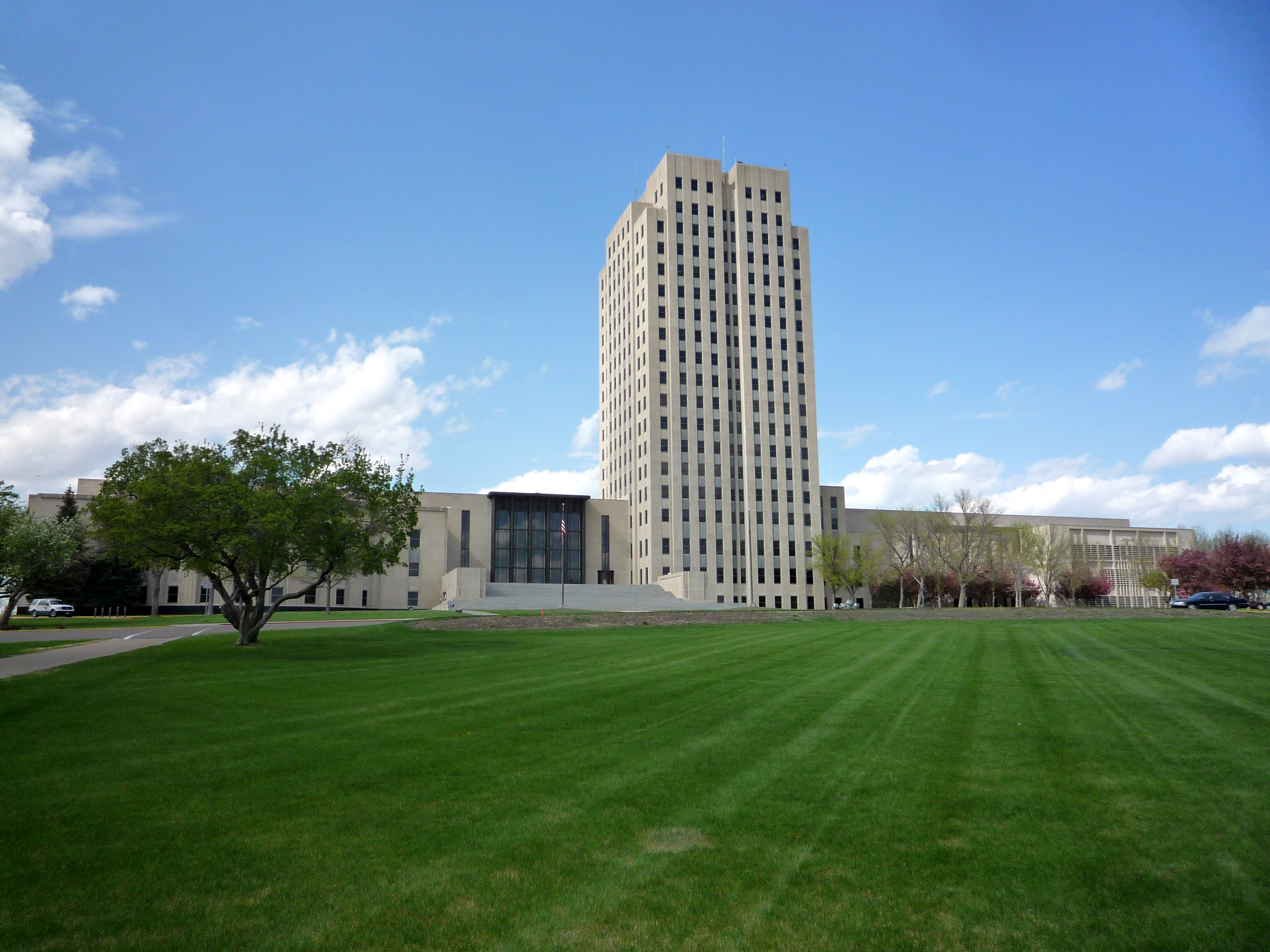 North Dakota State Capitol | |
 Flag | |
 Location within Burleigh County in North Dakota | |
 Bismarck Location within the United States | |
| Coordinates: 46°48′30″N 100°47′1″W | |
| Country | United States |
| State | North Dakota |
| County | Burleigh |
| Founded | May 14, 1872 |
| Named for | Otto von Bismarck |
| Government | |
| • Mayor | Mike Schmitz |
| Area | |
| • State capital city | 35.18 sq mi (91.12 km2) |
| • Land | 34.69 sq mi (89.83 km2) |
| • Water | 0.50 sq mi (1.29 km2) |
| Elevation | 1,686 ft (514 m) |
| Population (2020) | |
| • State capital city | 73,622 |
| • Rank | US: 497th ND: 2nd |
| • Density | 2,122.59/sq mi (819.54/km2) |
| • Urban | 81,955 (349th) |
| • Metro | 134,417 (308th) |
| Time zone | UTC-6 (CST) |
| • Summer (DST) | UTC-5 (CDT) |
| ZIP codes | 58501–58507 |
| Area code | 701 |
| FIPS code | 38-07200 |
| GNIS feature ID | 1035849[2] |
| Website | bismarcknd.gov |
Bismarck was founded by European-Americans in 1872 on the east bank of the Missouri River. It has been North Dakota's capital city since 1889 when the state was created from the Dakota Territory and admitted to the Union.
Bismarck is across the river from Mandan, named after a historic Native American tribe of the area.[7] The two cities make up the core of the Bismarck–Mandan Metropolitan Statistical Area.
The North Dakota State Capitol is in central Bismarck. The state government employs more than 4,600 in the city. As a hub of retail and health care, Bismarck is the economic center of south-central North Dakota and north-central South Dakota.
History
For thousands of years, present-day central North Dakota was inhabited by indigenous peoples, who created successive cultures. The historic Mandan Native American tribe occupied the area long before Europeans arrived. The Hidatsa name for Bismarck is mirahacii arumaaguash ("Place of the tall willows");[8] the Arikara name is ituhtaáwe [itUhtaáwe].[9]
In 1872 European Americans founded a settlement at what was then called Missouri Crossing, so named because the Lewis and Clark Expedition crossed the river there on their exploration of the Louisiana Purchase in 1804–06. It had been an area of Mandan settlement. Later the new town was called Edwinton, after Edwin Ferry Johnson, engineer-in-chief for the Northern Pacific Railway. Its construction of railroads in the territory attracted workers and settlers.
In 1873, the Northern Pacific Railway renamed the city Bismarck in honor of German chancellor Otto von Bismarck. Railroad officials hoped to attract German immigrant settlers to the area and German investment in the railroad.[10] It is the only U.S. state capital named for a foreign statesman. The discovery of gold in the nearby Black Hills of South Dakota the following year was a greater impetus for growth. Thousands of miners came to the area, encroaching on what the Lakota considered sacred territory and leading to heightened tensions with the Native Americans. Bismarck became a freight-shipping center on the "Custer Route" from the Black Hills.[10] In 1883 Bismarck was designated as the capital of the Dakota Territory, and in 1889 as the state capital of the new state of North Dakota.
Geography

According to the U.S. Census Bureau, the city has an area of 31.23 square miles (80.89 km2), of which 30.85 square miles (79.90 km2) is land and 0.38 square miles (0.98 km2) is water.[11]
Cityscape

The city has developed around downtown Bismarck, the center of historic development. It is distinctive because the city's major shopping center, Kirkwood Mall, is in the city center rather than in the suburbs. Several other major retail stores are in the vicinity of Kirkwood Mall, which was developed near the Bismarck Civic Center. The two Bismarck hospitals, CHI St. Alexius Medical Center and Sanford Health (previously Medcenter One Health Systems) are both downtown. The streets are lined with small stores and restaurants.
Much recent commercial and residential growth has taken place in the city's northern section, largely because of expanding retail centers. Among the shopping centers in northern Bismarck are Gateway Fashion Mall, Northbrook Mall, Arrowhead Plaza, and the Pinehurst Square "power center" mall.
The North Dakota State Capitol complex is just north of downtown Bismarck. The 19-story Art Deco capitol is the tallest building in the state, at a height of 241.75 feet (73.69 m). The capitol building towers over the city's center and is easily seen from 20 miles (32 km) away on a clear day. Completed during the Great Depression in 1934, it replaced a capitol building that burned to the ground in 1930. The capitol grounds encompass the North Dakota Heritage Center, the North Dakota State Library, the North Dakota Governor's Residence, the State Office Building, and the Liberty Memorial Building. The North Dakota State Penitentiary is in eastern Bismarck.
The Cathedral District, named after the Art Deco Cathedral of the Holy Spirit, is an historic neighborhood near downtown Bismarck. Some homes in this neighborhood date to the 1880s, although many were built in the first decades of the 20th century. At times, the city has proposed widening the streets in the neighborhood to improve traffic flow. Many residents object because such a project would require the removal of many of the towering American elms which line the streets. These have escaped the elm disease that destroyed street canopies of trees in eastern cities.
After the completion of Garrison Dam in 1953 by the Army Corps of Engineers, which improved flood control, the floodplain of the Missouri River became a more practical place for development. Significant residential and commercial building has taken place in this area on the south side of the city. The Upper Missouri River is still subject to seasonal flooding.
Climate
Situated in the middle of the Great Plains, between the geographic centers of the United States and Canada, Bismarck displays a highly variable four-season humid continental climate (Köppen Dfa/Dfb). Bismarck's climate is characterized by very cold, somewhat dry, snowy, and windy winters, and warm, humid summers. Thunderstorms occur in spring and summer, but much of the rest of the year is dry.
The warmest month in Bismarck is July, with a daily mean of 71.3 °F (21.8 °C),[12] with typically wide variations between day and night. The coldest month is January, with a 24-hour average of 12.8 °F (−10.7 °C).[12] Precipitation peaks from May to September and is rather sparse in the winter months. Winter snowfall is typically light to moderate, occurring with the passage of frontal systems; major storms are rare.
| Month | Jan | Feb | Mar | Apr | May | Jun | Jul | Aug | Sep | Oct | Nov | Dec | Year |
|---|---|---|---|---|---|---|---|---|---|---|---|---|---|
| Record high °F (°C) | 63 (17) |
73 (23) |
81 (27) |
93 (34) |
102 (39) |
111 (44) |
114 (46) |
109 (43) |
105 (41) |
95 (35) |
79 (26) |
66 (19) |
114 (46) |
| Mean maximum °F (°C) | 46.7 (8.2) |
49.9 (9.9) |
66.7 (19.3) |
80.2 (26.8) |
87.1 (30.6) |
93.2 (34.0) |
98.3 (36.8) |
98.2 (36.8) |
93.0 (33.9) |
82.1 (27.8) |
63.9 (17.7) |
49.4 (9.7) |
101.4 (38.6) |
| Average high °F (°C) | 23.2 (−4.9) |
27.8 (−2.3) |
41.0 (5.0) |
56.0 (13.3) |
68.3 (20.2) |
77.9 (25.5) |
84.7 (29.3) |
83.5 (28.6) |
73.4 (23.0) |
57.1 (13.9) |
40.6 (4.8) |
27.7 (−2.4) |
55.1 (12.8) |
| Daily mean °F (°C) | 12.8 (−10.7) |
17.5 (−8.1) |
30.1 (−1.1) |
43.2 (6.2) |
55.3 (12.9) |
65.4 (18.6) |
71.3 (21.8) |
69.6 (20.9) |
59.7 (15.4) |
44.8 (7.1) |
29.9 (−1.2) |
17.9 (−7.8) |
43.1 (6.2) |
| Average low °F (°C) | 2.4 (−16.4) |
7.2 (−13.8) |
19.1 (−7.2) |
30.4 (−0.9) |
42.4 (5.8) |
52.9 (11.6) |
57.9 (14.4) |
55.7 (13.2) |
45.9 (7.7) |
32.6 (0.3) |
19.1 (−7.2) |
8.1 (−13.3) |
31.1 (−0.5) |
| Mean minimum °F (°C) | −23.8 (−31.0) |
−17.6 (−27.6) |
−4.7 (−20.4) |
13.4 (−10.3) |
26.9 (−2.8) |
39.7 (4.3) |
46.2 (7.9) |
43.3 (6.3) |
29.8 (−1.2) |
15.9 (−8.9) |
−1.0 (−18.3) |
−16.0 (−26.7) |
−27.9 (−33.3) |
| Record low °F (°C) | −45 (−43) |
−45 (−43) |
−36 (−38) |
−12 (−24) |
13 (−11) |
30 (−1) |
32 (0) |
32 (0) |
10 (−12) |
−10 (−23) |
−30 (−34) |
−43 (−42) |
−45 (−43) |
| Average precipitation inches (mm) | 0.48 (12) |
0.52 (13) |
0.84 (21) |
1.34 (34) |
2.50 (64) |
3.36 (85) |
3.07 (78) |
2.50 (64) |
1.72 (44) |
1.43 (36) |
0.69 (18) |
0.60 (15) |
19.05 (484) |
| Average snowfall inches (cm) | 8.9 (23) |
7.5 (19) |
8.5 (22) |
4.6 (12) |
0.4 (1.0) |
0.0 (0.0) |
0.0 (0.0) |
0.0 (0.0) |
0.0 (0.0) |
2.5 (6.4) |
8.0 (20) |
10.1 (26) |
50.5 (128) |
| Average precipitation days (≥ 0.01 in) | 7.8 | 7.9 | 7.5 | 8.1 | 10.4 | 11.6 | 9.7 | 8.0 | 7.3 | 7.2 | 6.6 | 7.7 | 99.8 |
| Average snowy days (≥ 0.1 in) | 9.9 | 8.7 | 6.3 | 2.7 | 0.4 | 0.0 | 0.0 | 0.0 | 0.0 | 2.5 | 8.0 | 10.1 | 44.6 |
| Average relative humidity (%) | 71.3 | 72.4 | 69.9 | 61.8 | 60.1 | 65.0 | 61.8 | 60.6 | 63.7 | 63.8 | 72.0 | 74.5 | 66.4 |
| Average dew point °F (°C) | 2.3 (−16.5) |
8.6 (−13.0) |
18.9 (−7.3) |
28.6 (−1.9) |
39.6 (4.2) |
50.5 (10.3) |
54.9 (12.7) |
52.0 (11.1) |
42.4 (5.8) |
32.2 (0.1) |
19.8 (−6.8) |
7.5 (−13.6) |
29.8 (−1.2) |
| Mean monthly sunshine hours | 149.4 | 153.5 | 222.3 | 244.3 | 296.1 | 318.1 | 354.6 | 316.2 | 245.9 | 191.7 | 122.6 | 122.9 | 2,737.6 |
| Percent possible sunshine | 53 | 53 | 60 | 60 | 64 | 67 | 74 | 72 | 65 | 57 | 43 | 46 | 61 |
| Source: NOAA (relative humidity and sun 1961–1990)[12][13][14] | |||||||||||||
Demographics
| Historical population | |||
|---|---|---|---|
| Census | Pop. | %± | |
| 1880 | 1,758 | — | |
| 1890 | 2,186 | 24.3% | |
| 1900 | 3,319 | 51.8% | |
| 1910 | 4,913 | 48.0% | |
| 1920 | 7,122 | 45.0% | |
| 1930 | 11,090 | 55.7% | |
| 1940 | 15,496 | 39.7% | |
| 1950 | 18,541 | 19.7% | |
| 1960 | 27,670 | 49.2% | |
| 1970 | 34,703 | 25.4% | |
| 1980 | 44,485 | 28.2% | |
| 1990 | 49,256 | 10.7% | |
| 2000 | 55,532 | 12.7% | |
| 2010 | 61,272 | 10.3% | |
| 2020 | 73,622 | 20.2% | |
| 2021 (est.) | 74,138 | [15] | 0.7% |
| U.S. Decennial Census[16] 2020 Census[4] | |||
2020
As of the census of 2020, there were 73,622 people and 32,044 households residing in the city. The racial makeup of the city was 89.8% White, 2.7% African American, 4.3% Native American, 0.9% Asian, 0.1% from Native Hawaiian, and 1.8% from two or more races. Hispanic or Latino of any race were 2.5% of the population.
There were 32,044 households, the average household size of which was 2.2.
6.7% of residents were under the age of five; 21.8% of residents were between the ages of six and 18; 17% of residents were over the age of 65. The gender makeup of the city was 49.6% male and 50.4% female.[17]
2010
As of the census[18] of 2010, there were 61,272 people, 27,263 households, and 15,624 families residing in the city. The population density was 1,986.1 inhabitants per square mile (766.8/km2). There were 28,648 housing units at an average density of 928.6 per square mile (358.5/km2). The racial makeup of the city was 92.4% White, 0.7% African American, 4.5% Native American, 0.6% Asian, 0.3% from other races, and 1.5% from two or more races. Hispanic or Latino of any race were 1.3% of the population. In terms of ancestry, 56.1% were of German, 20.5% were of Norwegian, 7.2% were of Irish, 6.7% were of Russian, 3.7% were of American, 3.6% were of English descent.
There were 27,263 households, of which 27% had children under the age of 18 living with them (the lowest percentage in North Dakota[19]), 44.1% were married couples living together, 9.6% had a female householder with no husband present, 3.6% had a male householder with no wife present, and 42.7% were non-families. 34.8% of all households were made up of individuals, and 11.7% had someone living alone who was 65 years of age or older. The average household size was 2.18 and the average family size was 2.82.
The median age in the city was 38 years. 20.8% of residents were under the age of 18; 11% were between the ages of 18 and 24; 26.2% were from 25 to 44; 26.8% were from 45 to 64; and 15.4% were 65 years of age or older. The gender makeup of the city was 48.6% male and 51.4% female.
2000
As of the census of 2000, there were 55,532 people, 23,185 households, and 14,444 families residing in the city. The population density was 2,065.2 per square mile (797.4/km2). There were 24,217 housing units at an average density of 900.6 per square mile (347.7/km2). The racial makeup of the city was 94.78% White, 3.39% Native American, 0.89% from two or more races, 0.75% Hispanic or Latino, 0.45% Asian, 0.28% Black or African American, 0.17% from other races and 0.03% Pacific Islander.
There were 23,185 households, of which 30.2% had children under the age of 18 living with them, 50.1% were married couples living together, 9.3% had a female householder with no husband present, and 37.7% were non-families. 31.0% of all households were made up of individuals, and 10.5% were someone living alone who was 65 years of age or older. The average household size was 2.32 and the average family size was 2.94.
In the city, the population was spread out, with 23.5% under the age of 18, 11.1% from 18 to 24, 29.1% from 25 to 44, 22.4% from 45 to 64, and 13.8% who were 65 years of age or older. The median age was 36 years. For every 100 females, there were 93.9 males. For every 100 females age 18 and over, there were 91.8 males.
The median income per household in the city was $39,422, and the median income per family was $51,477. Males had a median income of $33,804 versus $22,647 for females. The per capita income for the city was $20,789. About 5.7% of families and 8.4% of the population were below the poverty line, including 9.5% of those under age 18 and 7.4% of those age 65 or over.
Economy
According to the city's 2020 Comprehensive Annual Financial Report,[20] the largest employers in the city are the following:
| # | Employer | # of Employees |
|---|---|---|
| 1 | State of North Dakota | 4,600 |
| 2 | Sanford Health | 3,284 |
| 3 | Bismarck Public Schools | 2,187 |
| 4 | CHI St. Alexius Medical Center | 2,044 |
| 5 | United States Government Offices | 1,200 |
| 6 | Bismarck State College | 719 |
| 7 | Walmart North/South | 665 |
| 8 | Aetna | 660 |
| 9 | University of Mary | 642 |
| 10 | City of Bismarck | 643 |
| 11 | MDU Resources | 592 |
| 12 | Bobcat/Doosan Company | 582 |
| 13 | Missouri Slope Lutheran Care Center | 560 |
| 14 | Basin Electric Power Cooperative | 560 |
| 15 | Coventry Health Care | 550 |
| 16 | Mid Dakota Clinic | 540 |
Arts and culture
The Belle Mehus Auditorium, named after a local piano teacher, is a 1914 historic building in downtown Bismarck and is a center for the arts in the area.[21] Performances of Northern Plains Dance and the Bismarck-Mandan Symphony Orchestra are held there.
Theater companies in Bismarck include the Capitol Shakespeare Society,[22] Sleepy Hollow Summer Theatre,[23] the Shade Tree Players children's theater group,[24] Dakota Stage Ltd,[25] University of Mary, Bismarck State College, and various high school groups. The Gannon and Elsa Forde Art Galleries are at Bismarck State College. The Missouri Valley Chamber Orchestra, founded in 2000, is the community's newest orchestra and performs a variety of musical genres.
Libraries
Bismarck libraries include Bismarck Veterans Memorial Public Library[26] and North Dakota State Library.[27]
Sports
Amateur
High school and college sports are the main feature of the local athletics landscape. The athletic teams at the three public Bismarck high schools, Bismarck High School, Century High School, and Legacy High School, are known as The Demons, The Patriots, and The Sabers, respectively. The athletic teams at St. Mary's Central High School, Bismarck's Catholic high school, are known as The Saints. The teams at Bismarck State College and United Tribes Technical College are known as The Mystics and Thunderbirds, and both compete in the National Junior College Athletic Association. The teams at the University of Mary are The Marauders and compete in the Northern Sun Intercollegiate Conference. Bismarck has an American Legion baseball team called the Governors.
In the fall, the accent is on high school and college football. There are spirited rivalries among the several high schools in the area. The University of Mary added the sport in 1988. Most University of Mary football games are played in the Community Bowl. Other popular sports during the winter months include ice hockey, wrestling and basketball.
In spring, baseball is one of the top amateur sports in the city with each high school, Bismarck State College, and The University of Mary providing teams. The University of Mary also has a softball team. High schools and colleges also feature track and field during the spring.
In the summer, Bismarck has American Legion baseball and auto racing. The Fourth of July holiday is the height of rodeo time, with rodeos in Mandan and Bismarck. Slow-pitch softball is played by teams in the city. Bismarck is the host city of the world's largest charity softball tournament, the Sam McQuade Sr. Softball Tournament, in which more than 400 teams from all over the United States and Canada compete.
The Bismarck Bobcats hockey team of the North American Hockey League is made up of junior players (age twenty and younger, sometimes age twenty-one if waived). The Bobcats won back-to-back Borne Cup championships as members of the America West Hockey League before merging into the NAHL in 2003. The Bobcats have made several trips to the NAHL's national tournament, claiming their first-ever Robertson Cup title in 2010.
Since 2017, the Bismarck Larks, a Northwoods League expansion baseball team, has played their home games at the Bismarck Municipal Ballpark.[28]
Professional
The Dakota Wizards of the NBA Development League was formerly based in Bismarck. The Wizards' first season took place in 1995 in the International Basketball Association. The Wizards won one title during their International Basketball Association days (1995–2001) and two during their Continental Basketball Association days (2001–2006). They were the 2006–2007 champions of the NBA D-League, their first season in the league. The team moved to Santa Cruz, California, in 2012, a year after being purchased by the Golden State Warriors of the National Basketball Association.
Starting with the 2017 season, Bismarck is home to the Bismarck Bucks, a professional indoor football team in the Indoor Football League. Bismarck has been the home of two professional indoor football teams, the Bismarck Blaze and the Bismarck Roughriders, but both teams left the city soon after they were formed.
Bismarck once had a professional baseball team, the Dakota Rattlers, but the team moved to Minot after several seasons in Bismarck.
Parks and recreation
Bismarck has a large park system and an extensive network of exercise trails. The Bismarck Parks and Recreation District, established in 1927, operates many parks, swimming pools, and several golf courses within the city. The World War I Memorial Building, which is listed on the National Register of Historic Places and operated by the recreation district, serves as a community gymnasium and was recognized by a 100 Cities 100 Memorials grant in 2018.[29]
The Parks and Recreation District operates roughly 2,300 acres (930 ha) of public parkland.[30] Sertoma Park stretches more than 3 miles (4.8 km) along the banks of the Missouri River. Within the park are several miles of biking trails and the Dakota Zoo.
There are five golf courses in Bismarck: four 18-hole courses (Apple Creek Country Club, Hawktree Golf Club, Riverwood Golf Course, and Tom O'Leary Golf Course), and one nine-hole course (Pebble Creek Golf Course).
Hunting and fishing are popular in the area, with hunting seasons for deer, pheasant, and waterfowl. Fishing is a year-round sport on the Missouri River bordering Bismarck, and there are public docks on the river. From north to south, there is a dock at the Port of Bismarck, from which the Lewis and Clark passenger riverboat plies the Missouri; Fox Island Landing, about a half mile southwest of Riverwood Golf Course; and the Bismarck Dock at General Sibley Park, which has a boat ramp and picnic facilities.
In February 2007, Bismarck broke the record for the most snow angels made in one place. A total of 8,962 participants came to the capitol grounds for the event.[31]
Government
Bismarck operates under the city commission style of municipal government. Citizens elect four commissioners on an at-large basis for terms of four years. The commission exercises both legislative and executive powers, with each commissioner exercising oversight over several city departments. The mayor, also elected at-large, serves as president of the commission and has few powers over and above his fellow commissioners. The mayor and commissioners serve four-year terms, with a limit of three consecutive terms.
The mayor is Mike Schmitz.[32] The city commission meets every second and fourth Tuesday of each month.
Education
Elementary, middle and high schools
The Bismarck Public Schools system operates sixteen elementary schools, three middle schools (Simle, Wachter, Horizon), three public high schools (Century High, Legacy High School, and Bismarck High) and one alternative high school (South Central High School). The system educates 13,350 students and employs 1,500 people.
Three Bismarck Catholic parishes operate primary schools (kindergarten through eighth grade): St. Mary's Grade School, St. Anne's Grade School, and Cathedral Grade School. St. Mary's Grade School, founded in 1878, is the oldest continuously operating elementary school in North Dakota.
The city has three private high schools: the Catholic St. Mary's Central High School, Shiloh Christian School, operated by Protestants, and Dakota Adventist Academy.
Higher education
There are three colleges and a university in Bismarck. The University of Mary[33] is a four-year university, operated by the Benedictine Sisters of Annunciation Monastery.[34] Bismarck State College[35] is a two-year public college, the largest degree-granting institution in the city, and a member of the North Dakota University System. United Tribes Technical College[36] is a two-year tribal college. Sanford Health, formerly Medcenter One, operates a nursing school that offers a Bachelor of Science in nursing. The campus is just north of the medical center in central Bismarck.
Media
Bismarck is served by the Bismarck Tribune, the city's daily newspaper. Established in 1873, the paper is the oldest continuously operating business in the city. The Tribune is the official newspaper of the city of Bismarck, Burleigh County, and the state of North Dakota.[37] The daily newspapers of other major cities in North Dakota are also available at area newsstands.
Television
Bismarck is the center of a television market covering most of western North Dakota and portions of Montana. Five stations are based in Bismarck. The four commercial stations have rebroadcasters in Minot, Williston, and Dickinson. The stations are:
- KBME (ATSC RF channel 22) – virtual channels 3.1 PBS, 3.2 World, 3.3 Minnesota Channel, 3.4 Lifelong Learning
- KFYR (ATSC RF channel 31) – virtual channels 5.1 NBC, 5.2 Me-TV
- KXMB (ATSC RF channel 12) – virtual channels 12.1 CBS, 12.3 Weather
- KBMY (ATSC RF channel 17) – virtual channels 17.1 ABC
- KNDB (ATSC RF channel 26) – virtual channels 26.1 Fox
Bismarck also carries KWMK, an affiliate of The CW, on cable channel 14; as well as Public-access television channels, on cable TV channels 2 and 12.
Radio
Bismarck supports 27 radio stations. Most of the commercial stations are owned by either iHeartMedia or Cumulus Media. Many of the lower frequency stations are broadcasters of national Christian radio networks. The local stations are:
FM frequencies
- KBMK 88.3 FM (Contemporary Christian music) K-Love network affiliate
- K204FG 88.7 FM (Christian) BBN translator
- KLBF 89.1 FM (Christian) Faith Radio from the University of Northwestern - St Paul
- KNRI 89.7 FM (Christian rock) Air 1 affiliate
- KCND 90.5 FM (Public Radio) Prairie Public Radio
- KXRP 91.3 FM (Christian) Family Radio affiliate
- KPHA 91.7 FM (Catholic) Real Presence Radio
- KYYY 92.9 FM (Adult Contemporary) "Mix 92.9"
- KBEP-LP 93.7 FM (Christian) 3ABN affiliate
- KQDY 94.5 FM (Country) "KQ 94.5"
- K237FQ 95.3 FM translator simulcasting KJIT-LP
- KBYZ 96.5 FM (Classic rock) "The Walleye"
- KKCT 97.5 FM (Top 40/CHR) "Hot 97-5"
- KACL 98.7 FM (Classic hits) "Cool 98.7"
- K259AF 99.7 FM translator simulcasting KFYR-AM
- KLBE-LP 100.7 FM (Christian rock) "Club Radio"
- KSSS 101.5 FM (Mainstream Rock) "Rock 101"
- KUSB 103.3 FM (Country) "US 103.3"
- KNDR 104.7 FM (Contemporary Christian music)
- KKBO 105.9 FM (Country) "Big Rig 105.9"
- KJIT-LP 106.7 FM (Contemporary Christian music) Radio 74 affiliate
- KXRV 107.5 FM (Classic Hits) "Mojo 107.5"
AM frequencies
- KFYR 550 AM (News/Talk/Sports/Oldies/Classic Hits/Top 40/CHR) "K-Fire"
- KXMR 710 AM (Sports) "ESPN 710"
- KBMR 1130 AM (Classic country) "Bismarck's original country station"
- KLXX 1270 AM (Talk)
- KDKT 1410 AM (Sports) "Fox Sports Radio 1410"
- WQDL503 1610 AM (Traveler's Information Station), North Dakota Department of Transportation
NOAA Weather Radio station WXL78 broadcasts from Bismarck on 162.475 MHz.
Infrastructure
Health care
Bismarck is a regional center for health care. The city has two hospitals: CHI St. Alexius Medical Center (285-bed) and Sanford Health (238-bed). When it opened in 1885, St. Alexius was the first hospital in Dakota Territory and the Catholic facility is the oldest health care provider in the state. St. Alexius and Medcenter One have joined forces to form the Bismarck Cancer Center.[38] Medcenter One was founded in 1908 as Bismarck Evangelical Hospital. In 1955 it was renamed Bismarck Hospital. In 1984 it was renamed MedCenter One, and in 2012 it became part of the Sanford Health system.[39]
Transportation
Public transit

The Capital Area Transit System (CAT), operated by Bis-Man Transit, began operations in May 2004.[40] This public bus system has eleven routes throughout Bismarck and Mandan, Monday-Saturday. Bis-Man Transit also operates a para-transit service for senior citizens and people with disabilities.[41]
Bismarck had electric streetcar service from 1904 to 1931.
Aviation
Bismarck Municipal Airport is south of the city. It has the largest passenger volume in western North Dakota and the second highest within the state. The airport is served by United Express, Allegiant Air, Delta Air Lines, American Airlines, and Frontier Airlines. A new $15 million terminal opened in May 2005. The previous terminal was built in the mid-1960s and expanded in the mid-1970s. After a windstorm collapsed part of the roof connecting the expanded terminal to the original building, officials decided to demolish the entire complex and build the new terminal.
Rail service
The BNSF Railway runs east–west through the city. The railway was originally integral to the growth of Bismarck and Mandan. Today it is used for freight. Due to restructuring in the railroad industry, there has not been passenger train service to Bismarck station since Amtrak's North Coast Hiawatha service ended in 1979. The closest Amtrak station is in Minot, north of Bismarck, which is served by the Empire Builder.
Roadways
Two federal highways pass through Bismarck. Interstate 94 runs east–west through the city. The north–south U.S. Route 83 merges in north Bismarck with Interstate 94 and runs east for roughly 25 miles (40 km) before turning south.
Walking & Cycling
BisParks BCycle is a public bikeshare system with four docks situated around the city. Bismarck is not ranked as a walk-friendly community, and is rated bronze for bike-friendliness. [42][43]
Notable people
- Sam Aanestad, dentist and California state legislator[44]
- David Andahl, businessman and politician[45]
- Shane Balkowitsch, American wet plate photographer[46]
- Carmen Berg, Playboy Playmate (July 1987)
- Leslie Bibb, actress[47]
- Paula Broadwell,[48] a consultant and author[49] and extramarital partner of General David Petraeus[50]
- John Burke, state Supreme Court Justice, tenth governor of North Dakota, 24th Treasurer of the United States[51]
- Gary Cederstrom, Major League Baseball umpire[52]
- Neil Churchill, Bismarck mayor[citation needed]
- Dale Clausnitzer, Minnesota state legislator and businessman[53]
- Kent Conrad, U.S. Senator[54]
- Ronnie Cramer, artist, filmmaker
- Dale DeArmond, printmaker and book illustrator[55]
- Weston Dressler, Saskatchewan Roughriders slotback[56]
- Shannon Galpin, founder of "Strength in Numbers"
- Linnea Glatt, post-modern sculptor and installationist
- John Hoeven, U.S. Senator, (since 2011) 31st Governor of North Dakota (2000–2010)[57]
- Clay Jenkinson, Author, Thomas Jefferson scholar
- Thomas S. Kleppe, former Bismarck mayor, 41st U.S. Secretary of the Interior[58]
- Brock Lesnar, wrestler and former heavyweight UFC champion[59]
- Conrad Mandsager, entrepreneur and innovator, organization founder[60]
- Cara Mund, Miss America 2018
- Mike Peluso, right wing with the Chicago Blackhawks and Philadelphia Flyers[61]
- John Andrew Rea, newspaper editor, helped draft the state constitution
- Mel Ruder, Pulitzer Prize winning journalist[62]
- Ed Schafer, 30th Governor of North Dakota, 29th U.S. Secretary of Agriculture[63]
- Jonathan Twingley, artist, illustrator and novelist[64]
- Carson Wentz, professional football player for the Washington Commanders[65]
Mayors of Bismarck
- Edmond Hackett; 1875
- John A. Mclean; 1875–1877
- George Peoples; 1877–1881
- R. B. Thurston; 1881–1882
- James W Raymond; 1882–1884
- John P. Dunn; 1884–1885
- John E. Carland; 1885–1886
- Israel P Hunt; 1886–1887
- William A. Bently; 1887–1890
- Isaac P. Baker; 1890–1891
- William A. Bently; 1891–1892
- Edward S. Allen; 1892–1894
- Albert N. Leslie; 1894–1896
- Edward G. Patterson; 1896–1900
- Francis H. Register; 1901–1905
- William H. Webb; 1905–1907
- Francis R. Smyth; 1907–1909
- Erastus A. Williams; 1909–1913
- Arthur W. Lucas; 1913–1921
- Amil P. Lenhart; 1921–1937
- Obert A. Olson; 1937–1938
- Neil O. Churchill; 1939–1946
- Amil P. Lenhart; 1946–1950
- Thomas S. Kleppe; 1950–1954
- Evan Lips; 1954–1966
- Ed V. Lahr; 1966–1974
- Robert O. Heskin; 1974–1978
- Eugene Leary; 1978–1986
- Marlan Haakenson; 1986–1990
- Bill Sorensen; 1990–2002
- John Warford; 2002–2014
- Mike Seminary; 2014–2018
- Steve Bakken; 2018–2022[66]
- Mike Schmitz; 2022–present[32]
See also
- Bismarck Air Museum
- Bismarck-Mandan Symphony Orchestra
- North Dakota Heritage Center
Notes
- Mean monthly maxima and minima (i.e. the highest and lowest temperature readings during an entire month or year) calculated based on data at said location from 1991 to 2020.
- Records for Bismarck have been kept at the Bismarck Municipal Airport since January 1948 and at an undisclosed location from October 1874 to December 1947.
References
- "ArcGIS REST Services Directory". United States Census Bureau. Retrieved September 20, 2022.
- "US Board on Geographic Names". United States Geological Survey. October 25, 2007. Archived from the original on February 4, 2012. Retrieved January 31, 2008.
- "Find a County". National Association of Counties. Archived from the original on May 31, 2011. Retrieved June 7, 2011.
- "Explore Census Data". United States Census Bureau. Retrieved May 29, 2022.
- Kotkin, Joel (September 3, 2014). "America's Fastest-Growing Small Cities". Forbes. Archived from the original on September 4, 2014. Retrieved September 3, 2014.
- "Metropolitan and Micropolitan Statistical Areas Population Totals and Components of Change: 2010-2019". Retrieved September 3, 2020.
- Murphy, Edward C.; Groenewold, Gerald H. "Geology of the Bismarck-Mandan Area" (PDF). Geologic Investigations No. 3. North Dakota Geological Survey. Archived (PDF) from the original on March 14, 2012. Retrieved February 28, 2012.
- "Hidatsa Lessons Vocab2". Hidatsa Language Program. Archived from the original on June 6, 2013. Retrieved July 17, 2012.
- "AISRI Dictionary Database Search-- Arikara. Prototype version". Archived from the original on July 2, 2014. Retrieved July 8, 2012.
- "Bismarck City Portrait". City of Bismarck. Archived from the original on November 20, 2010. Retrieved September 19, 2010.
- "US Gazetteer files 2010". United States Census Bureau. Archived from the original on January 12, 2012. Retrieved June 14, 2012.
- "NOWData - NOAA Online Weather Data". National Oceanic and Atmospheric Administration. Retrieved September 16, 2021.
- "Station Name: ND BISMARCK". U.S. Climate Normals 2020: U.S. Monthly Climate Normals (1991-2020). National Oceanic and Atmospheric Administration. Retrieved June 5, 2021.
- "WMO Climate Normals for BISMARCK/MUNICIPAL, ND 1961–1990". National Oceanic and Atmospheric Administration. Retrieved March 10, 2014.
- "City and Town Population Totals: 2020-2021". United States Census Bureau. May 29, 2022. Retrieved May 29, 2022.
- "U.S. Decennial Census". Census.gov. Retrieved May 25, 2013.
- "U.S. Census Bureau QuickFacts: Bismarck city, North Dakota". www.census.gov. Retrieved January 14, 2022.
- "U.S. Census website". United States Census Bureau. Retrieved June 14, 2012.
- "Best North Dakota Cities for Families and Singles". North Dakota Real Estate Trends. RealEstate.com. Archived from the original on September 15, 2012. Retrieved February 5, 2013.
- "City of Bismarck 2020 Comprehensive Annual Financial Report" (PDF). p. 141.
- "Belle Mehus Auditorium". Bismarck Event Center. Retrieved February 13, 2020.
- "Capitol Shakespeare :: Home". capitolshakespeare.org. Archived from the original on April 29, 2018. Retrieved April 29, 2018.
- "Sleepy Hollow". shst.org. Archived from the original on August 17, 2015. Retrieved May 31, 2015.
- "Dakota Stage Ltd". shadetreeplayers.com. Archived from the original on May 30, 2016. Retrieved May 31, 2015.
- "Dakota Stage Ltd". dakotastageltd.com. Archived from the original on August 1, 2015. Retrieved May 31, 2015.
- "Bismarck Library, ND". Archived from the original on July 31, 2017. Retrieved July 30, 2017.
- "Home – North Dakota State Library". nd.gov. Archived from the original on May 20, 2015. Retrieved May 31, 2015.
- Reidell, Robert (February 12, 2016). "Northwoods League team coming to Bismarck". The Bismarck Tribune. Archived from the original on February 16, 2016. Retrieved May 10, 2017.
- McCormack, Cheryl. "Local memorial honors WWI veterans, receives designation". Archived from the original on May 29, 2018. Retrieved May 29, 2018.
- Information about Bismarck Parks and Recreation District Archived February 12, 2007, at the Wayback Machine
- Nicholson, Blake (February 28, 2008). "Detroit radio station hopes to break snow angel record". USA Today. Archived from the original on June 28, 2011.
- Svihovec, Travis (June 14, 2022). "Schmitz easily unseats incumbent Bakken in Bismarck mayor's race". The Bismarck Tribune. Retrieved June 30, 2022.
- "University of Mary, North Dakota – Affordable Private Catholic College". umary.edu. Archived from the original on May 23, 2015. Retrieved May 31, 2015.
- "Benedictine Sisters of Annunciation Monastery". annunciationmonastery.org. Archived from the original on May 22, 2015. Retrieved May 31, 2015.
- "Bismarck State College". bismarckstate.edu. Archived from the original on May 31, 2015. Retrieved May 31, 2015.
- Justin Oleyte. "United Tribes Technical College". uttc.edu. Archived from the original on May 30, 2015. Retrieved May 31, 2015.
- "Contact Us". Bismarck Tribune. Archived from the original on July 22, 2017. Retrieved July 21, 2017.
- "Welcome to the Bismarck Cancer Center". bismarckcancercenter.com. Archived from the original on December 19, 2014. Retrieved May 31, 2015.
- "Medcenter One, Sanford Health Complete Merger". Archived from the original on July 8, 2012. Retrieved July 5, 2012.
- "Bis-Man Transit: Bismarck, ND: Public Transportation & Bus System". Bismarck, ND: Bis-Man Transit. Retrieved May 29, 2022.
- "Bismarck, ND: Bis-Man Transit - CAT 101". Bismarck, ND: Bis-Man Transit. Retrieved May 29, 2022.
- "Walk Friendly communities". 26 September 2016. Retrieved October 10, 2022.
- "Bismarck-Mandan report card" (PDF). Retrieved October 10, 2022.
- "Roadblock Republicans - calitics". calitics.com.
- David Dean Andahl-obituary
- Meinch, Timothy. "A Frame in Time: Photography with Shane Balkowitsch". midwestliving.com. Archived from the original on September 24, 2017. Retrieved September 24, 2017.
- Owen, Rob (March 4, 2012). "Four former Richmonders help bring laughter to TV". Richmond Times-Dispatch. Retrieved April 23, 2016.
- Barney, Madison (January 30, 2012) Bismarck native profiles Gen. David Petraeus in new book. Archived November 12, 2012, at Wikiwix Bismarck Tribune
- "Bestsellers February 26, 2012". The New York Times. February 26, 2012. Archived from the original on May 15, 2013. Retrieved November 11, 2012.
- Horwitz, Sari (November 10, 2012). "FBI probe of Petraeus triggered by e-mail threats from biographer, officials say". The Washington Post. Archived from the original on November 10, 2012. Retrieved November 10, 2012.
- "John Burke". Architect of the Capitol. Archived from the original on February 18, 2012. Retrieved February 28, 2012.
- Skurzewski, Joe. "Longtime MLB umpire, Minot native Gary Cederstrom to retire". www.kfyrtv.com. Retrieved May 27, 2020.
- Minnesota Legislators Past & Present-Dale A. Clausnizzer
- "Kent Conrad". Biographical Directory of the United States Congress. Archived from the original on July 30, 2011. Retrieved September 23, 2013.
- "Dale DeArmond". Juneau Empire. November 29, 2006. Archived from the original on January 20, 2016. Retrieved December 27, 2015.
- "Weston Dressler". University of North Dakota. Archived from the original on July 4, 2014. Retrieved September 23, 2013.
- "John Hoeven". Biographical Directory of the United States Congress. Archived from the original on August 16, 2011. Retrieved September 23, 2013.
- "Thomas S. Kleppe". Biographical Directory of the United States Congress. Archived from the original on September 23, 2013. Retrieved September 23, 2013.
- "Brock Lesnar". National Wrestling Hall of Fame. Archived from the original on July 12, 2014. Retrieved September 23, 2013.
- "ChildVoice International". childvoiceintl.org. Archived from the original on July 7, 2012.
- "Mike Peluso". Sports Reference LLC. Archived from the original on September 27, 2013. Retrieved September 23, 2013.
- "Mel Ruder: Montana's first Pulitzer winner, dies at 85". Helena Independent Record. Retrieved November 28, 2020.
- "Ed Schafer". usda.gov. Archived from the original on September 27, 2013. Retrieved September 23, 2013.
- "Jonathan Twingley". University of the Arts. Archived from the original on July 20, 2017. Retrieved January 8, 2020.
- "Commanders acquire Carson Wentz | Commanders.com". www.commanders.com. Retrieved April 2, 2022.
- "Bismarck Mayors 1875 to Present.xisx". bismarcknd.gov. Archived from the original on July 9, 2021. Retrieved October 4, 2021.
External links
- City of Bismarck official website
- Bismarck, North Dakota at Curlie
- . Encyclopædia Britannica (11th ed.). 1911.
- . . 1914.
- Bismarck, capital of North Dakota (1916) from the Digital Horizons website
- Bismarck, capital of North Dakota (1923) from the Digital Horizons website
Municipalities and communities of Burleigh County, North Dakota, United States | ||
|---|---|---|
County seat: Bismarck | ||
| Cities |  | |
| Townships |
| |
| Unorganized territories |
| |
| CDPs | ||
| Other communities | ||
| Ghost town |
| |
| Footnotes | ‡This populated place also has portions in an adjacent county or counties | |
| ||
Bismarck–Mandan Metropolitan Area (ND) | ||
|---|---|---|
| Counties |  | |
| Core cities | ||
| Surrounding areas | ||
Authority control | |
|---|---|
| General | |
| National libraries | |
| Other |
|
На других языках
[de] Bismarck (North Dakota)
Bismarck ist die Hauptstadt des US-Bundesstaates North Dakota und des Burleigh County. Die Stadt am Missouri River ist die zweitgrößte des Bundesstaates. Sie ist Sitz eines katholischen Bistums und gilt als wichtiges Handelszentrum für Weizen und Vieh.- [en] Bismarck, North Dakota
[es] Bismarck (Dakota del Norte)
Bismarck es la capital del estado estadounidense de Dakota del Norte. Ubicada en el condado de Burleigh, cuenta con una población de 61 272 habs., según el censo de 2010, y una densidad poblacional de 758 hab/km².[2] Se encuentra junto al río Misuri, entre los lagos Sakakawea y Oahe.[ru] Бисмарк (Северная Дакота)
Би́смарк[1][2] (англ. Bismarck) — город в США, столица штата Северная Дакота и административный центр округа Бурли (англ. Burleigh County).Другой контент может иметь иную лицензию. Перед использованием материалов сайта WikiSort.org внимательно изучите правила лицензирования конкретных элементов наполнения сайта.
WikiSort.org - проект по пересортировке и дополнению контента Википедии